CHAPTER XV: The Waipa and the West Coast
[Image of page 305]
CHAPTER XV.
The Waipa and the West Coast.
The Taupiri. -- The Middle Waikato-Basin. -- Keeping the Sabbath. -- Waikato and Waipa. -- Residence of the Maori King. -- The chief Takerei. -- Terraces. -- Whatawhata. -- The Wesleyan Mission station Kopua. -- A Maori-wedding. -- Kakepuku. -- To Whaingaroa. -- Whaingaroa Harbour. -- The township of Raglan. -- Mount Karioi. -- The Aotea Harbour. -- The Kawhia Harbour. -- Ammonites and Belemnites. -- The New Zealand Helvetia. -- A Northumberlander. -- Roads to the Waipa. -- The bush. -- Back to the Waipa.
March 12. -- The Taupiri, as viewed from the Mission station, is a steep conical hill with a sloping-flat top, which rises immediately on the opposite, the right or East-bank of the Waikato, forming the most prominent point upon the boundary between the lower and the middle Waikato Basin. We crossed the river, and through ferns and bush reached the top in the space of an hour. My sanguine expectations of a brilliant prospect were not disappointed. Only to the North-east the continuation of the range obstructs the prospect into the distance. In all other directions the eye can freely rove far over the land. In clear weather even the Tongariro and the snow-capt peak of the Ruapahu are visible in the South. Although we were denied this pleasure, the sky being somewhat cloudy, yet the view of the adjoining country alone sufficed to impart to me an idea of New Zealand other than I had hitherto entertained.
Here I beheld for the first time an extensive low-land spreading into distant mountain-cones and remote mountain-chains. I
[Image of page 306]
was reminded of the fertile plains of Hungary or of the Rhine-valley, where the Neckar and the Main mingle with the Rhine. Like mirrors resplendent with the broken rays of the sun, you see glistening numerous lakes, and the serpentine currents of large rivers winding through the plains. The Waikato is the main-river in this richly watered, fertile basin, which, in its extent from the western to the eastern mountain-ranges, I call the Middle Waikato Basin. The Waikato flows through this basin in the direction from Southeast to Northwest, a distance of 35 miles. 1 Immediately at the foot of the Taupiri the Mangawaro joins it, running trough large swamps in the East, and 5 miles farther up it receives the Waipa, the principal tributary from the Southwest. Up the Waipa towards Southwest and South, along the western coast-range, the low-land extends as far as the slopes of the picturesque trachytic mountain Pirongia, and the spurs of the Rangitoto-range, where from the midst of the plain the Kakepuku rises with a regular conical shape. To the South-Southeast, where the Waikato enters from the southern table-land into the basin, there rises majestically the trachytic Maungatautari. Thence springs up a low range of hills, the Maungakawa-range, separating the eastern portion of the basin -- the plains of the Piako and Waiho, rivers of considerable size emptying into the Hauraki Gulf, -- from the Waikato and Waipa plains. But it is only the steep margin of the eastern coast-range, from the Patetere Plateau to the Aroha mountain, that forms the eastern boundary of the basin. This whole basin was previous to the last elevation of North Island, which was probably connected with the volcanic eruptions in the centre of the island, a bay of the sea, extending from the Hauraki Gulf far into the interior. The steep margin of the surrounding ranges has continued to this day displaying the sea-shore of old, and the singular terrace-formation on the declivities of the hills and the river-banks within this basin is the result of a slow and periodical upheaving.
[Inserted page]
[Image of page 307]
How much more charming would the smiling fields of this beautiful country have appeared to us, could we have beheld it studded with European towns and villages! The middle Waikato Basin is the home of the most powerful and most numerous Maori-tribes, whose king had fixed his residence by the confluence of the Waikato and Waipa at Ngaruawahia, and whose metropolis, -- if we may use the expression, -- may be considered Rangiawhia, a large settlement, situated between the Waipa and Waikato in the southern part of the basin, which has attained its importance especially by its extensive corn-trade and horse-breeding. In future decades this blessed region will be the granary of the North Island, -- a real Eden for agriculture and the breeding of cattle, to which, in this respect, no other part of New Zealand might easily compare. The height of the Taupiri above the level of the sea, as resulting from my barometrical measurements, amounts to 983 feet; it consists of a hard blackish-gray slate-rock, polyhedrally fissured. The top of this hill will be one of the principal points for a future triangulation of the country.
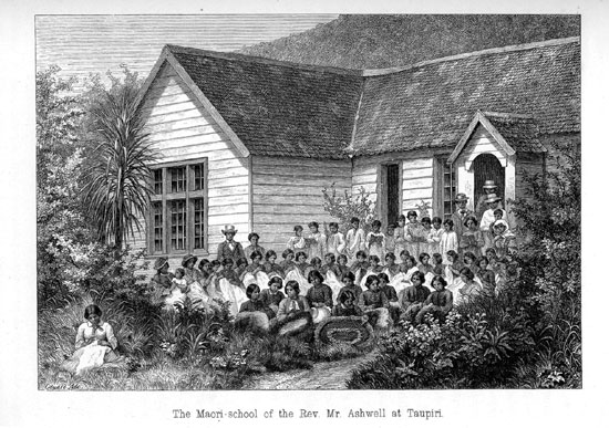
March 13. -- Sunday. -- The Sabbath in New Zealand is kept by both Europeans and natives, with still greater puritanic severity, than in England. Sunday is Ra tapu, a holy day, on which first of all it is not allowed to travel. A violation of the Sabbath would be censured with double severity in a gentleman on account of the bad example set by it to the natives. I for my part complied easily and willingly with this strict Sunday-law, since a day of rest in the week is a real matter of necessity to a pedestrian. Only once was I made to feel the severity of the law, when, compelled by a scarcity of provisions, I travelled on a beautiful Sunday morning a few miles farther to a Maori-village, where I hoped to supply the deficiency, but, after all, was literally compelled to fast there till Monday morning in expiation of my trespass. This time the day of rest was not only pleasant to me, but the truly beautiful manner of keeping the day at the Mission station made also an edifying impression upon my mind. The missionary school numbered 94 pupils, 46 girls and
[Image of page 308]
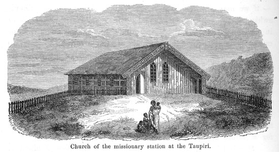
48 boys of different age. The church is a pretty specimen of a Maori building; its walls neatly plaited of various vegetable products of the country, 2 and its door-posts and gable-beams gayly painted. At 11 o'clock divine service commenced. Two and two, the school-children, all neatly and cleanly dressed, came march-
ing to church in a long procession. A large number of men and women from the adjoining villages and settlements followed them. The service consisted of a hymn, prayers, and a sermon delivered by a native with much spirit and lively action. Church-service over, I witnessed the Sabbath-school exercises, and was not little astonished at the geographical acquirements of those Maori-children. They very readily traced to me, upon a map of Europe without names, the course of the Danube pointing out the situation of Vienna; and quite correctly answered my questions as to the active volcanoes of Europe. At 2 o'clock dinner was had in the common dining-room. The Sunday-fare consisted of potatoes and
[Image of page 309]
pork. At 4 o'clock, there was English worship in the school-room, and, this also finished, I was shown various pieces of work from the hands of the Maori-girls, who are here instructed in different branches of domestic work, while the boys are trained for agriculture and all sorts of useful trades. A very pretty article of industry of the Taupiri Mission station are mats and carpets wrought of New Zealand flax in different colours. The children generally remain in the institute, until they are grown. Although the results of their education do not always realize just expectations, yet, it is only with the greatest respect and admiration that we can behold the sacrificing activity of such a missionary family upon New Zealand, whose members have all an equal share in the education and civilization of a people, that but a few decades ago was steeped in barbarity.
March 14. -- My collections, increased by contributions from the amiable ladies of the missionary's family, and by numerous birds, which a native by the name of Hone Papahewa had procured for me, I had an opportunity to dispatch to Auckland by the regular Maori mail-carrier. Then we decamped. Through the kind intercession of Mrs. Ashwell we had obtained an excellent canoe and the necessary number of paddles, and were thus enabled to continue our course up the river. Upon the fertile banks of the Waikato, above the Taupiri, there appears settlement after settlement with beautiful farm-lands, -- Hopuhopu, Kaumatuku, Pepepe, and what other names there are of those places. Owing to the strong current we proceeded but slowly up the river; and it was not before 12 o'clock, that we arrived at the confluence of the Waikato and Waipa, about 5 miles above Taupiri. Upon the point of land between the two rivers lies the Maori residence Ngaruawahia. 3 From political reasons, however, it was not the intention of Captain Hay, to pay a visit to His Maori Majesty, King Potatau te Wherowhero, at the very beginning of our journey; and consequently we passed by, without seeing more of the remarkable place
[Image of page 310]
than the flag-staff rising from among the bushes, on which on occasions of special solemnity the national flag is hoisted.
Leaving the Waikato we turned into the Waipa. The names of both rivers are indeed characteristic: Waikato, the streaming water; Waipa 4 the quiet or placid water; for while the Waikato runs at the rate of four to five miles per hour, the Waipa has at its mouth at the most a velocity of a half to one mile. The Waipa is in regard to water-supply greatly inferior to the Waikato; nevertheless it had, despite the low water mark, quite a distance up the river, a depth of from 8 to 12 feet. The temperature and the colour of the water in both rivers were likewise remarkably different. The Waikato showed 68 deg. Fahr., and its water was light-green and clear; while that of the Waipa showed the dark-brown colour of peat-water, and a temperature of 70 deg. Fahr. 5
The passage on the Waipa between high banks on the right
[Image of page 311]
and left, presented little that was attractive or worthy of notice. At 2 o'clock we landed near the old Pah Tekohai, for the purpose of paying a visit to the influential chief Takerei, who, as Captain Hay thought, deserved proofs of attention and respect on account of his loyal sentiments. The reception was very ceremonious. We found Takerei together with his friend Tara Hawaiki, and seated ourselves next to the two chiefs upon the unrolled mats. A long conversation on politics was commenced between Captain Hay and the chiefs, of which I understood nothing. I made my own silent observations. Never had I seen a handsomer Maori-head, one of nobler shape, than the proud head of Takerei, nor colder or more austere lineaments than those of his countenance, which was tattooed all over. No trace of a smile or even of friendly sympathy flitted over the man's marble face during our stay of several hours. There he sat cowering, a dirty woollen blanket abound him, smoking his pipe, and casting wild and gloomy glances about him. At the same time he gave the natives, who were passing to and fro, short, quick orders. There was something extremely imposing in the proud, austere mien of the man, who appeared to me as though wrought of steel; but at the same time also something exceedingly savage. And yet, Takerei is said to be a man very kindly disposed towards the Europeans; one, who, I was told, would have nothing to do with the Maori-king- movement, who donated a large piece of land for the establishment of a missionary school, and who was using all his influence to prevent the introduction of spirituous liquors (Wai pirau, or stinking water) into the country. It has been related of him, that he refused to let canoes pass, which had come up the river loaded with spirits. Takerei had ordered a repast for us, and there was no possibility -- unless we chose to be guilty of the most unpardonable breach of Maori-etiquete -- of taking our leave, before having eaten with the chiefs. At length, potatoes, eels and milk were placed before us, and with dusk fast settling into night we were able to continue our travel. The moon shining brightly, we proceeded as far as Karakariki. There we found the inhabitants of the village in a large hut gathered
[Image of page 312]
around two brightly blazing fires; it was a real gipsy-scene; but the news that Pakehas had arrived, roused them all to their feet; and till late in the night our tents were beset by crowds of curious spectators.
March 15. -- At the very first dawn of day, the Maoris paid their morning devotion; their chants resounding as far as our tents. Then they went to work, -- they were engaged in building a new church, -- and not until after a few hours labour did they sit down to breakfast. Such is the custom in all Maori-villages. The breakfast consisting of potatoes and fish, was prepared by the women for all at once; the breakfast-scene itself, however, was highly amusing, since the dogs, pigs and cats of the village were also all socially admitted to the meal.
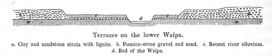
After breakfast we continued our course upon the Waipa. The farther up the river, the more distinctly appears the terrace-formation on both banks, which commences already below Karakariki.
The Waipa-valley, it must be remarked, has so to say, two stories. The river-bed is bordered by steep banks, which at low watermark are from 20 to 30 feet high. After these have been climbed, the first story or first terrace has been scaled of a fertile alluvial plain diligently cultivated by the natives, which is crossed by the river in various bends and curves, and represents, in some measure, a second, broader river-bed running in plainer lines, more elevated, and sometimes flooded by the river at heavy freshes. The natives call this first terrace Te Kotai. From this first story a steep margin, 30 to 40 feet high, leads to the second terrace or the second story, a large plain extending on both sides of the river, and gradually blending with the flat-rolling hills of the Waikato basin. The plain of the second terrace has also been cultivated nearly the whole length of the river; the huts and vil-
[Image of page 313]
lages of the natives are seen upon it, and here and there a small remnant of woods is still standing. Characteristic of this second terrace is -- since the river-bed does not rise towards South in the same proportion as the plains of the Waikato basin -- that up the river it rises higher and higher, until finally a third terrace is inserted between the first and second stories.
The geological features are extremely simple, and seem to remain the same through the entire middle Waikato basin. As lowest bed there appear layers of clay and sand with bituminous shale, which in some places enclose trunks of trees changed to lignite. Few miles above Karakariki the shale passes over into thin beds of argillaceous shale containing numerous fossil plants. They, however, would not admit of being gathered, the mass crumbling two readily. Worthy of notice are also some sporadic pumice-stone fragments, which are found embedded in it, These and similar strata seem to point to the fact that the whole middle Waikato basin was but recently a shallow bay of the sea, or a far extending estuary, at the bottom and on the margins of which those layers were formed. The topmost layer consists of gravel and sandbanks, for which pumice-stone, obsidian and various volcanic rocks have furnished the principal material. The sand contains moreover large quantities of magnetic iron, and small quartz-crystals as clear as water, originating partly from pumice-stone, partly from trachytic rocks (rhyolite). These quaternary layers of gravel and sand compose the broad plains of the second terrace, while upon the first river-terrace recent river-alluvium is deposited. A similar terrace-formation recurs with all the rivers of the middle Waikato basin. On the Waikato itself the terraces commence already below Kirikiriroa, on the Waiho in the vicinity of Mount Aroha.
About noon we halted by the Maori-village Whatawhata. Here I met a native Austrian, C. L. Strauss, who, he told me, had formerly been a Government official in Triest. By what adverse fates he was cast upon the shores of New Zealand, I do not know. He has been living among the natives for the last twenty years, and is married to a Maori-princess, a near relative to King Potatau,
[Image of page 314]
a very corpulent and goodnatured woman. Of this influential connection he seems to have made good use, and to have acquired a considerable fortune by dealing in corn; he spoke Maori and English with perfect fluency; but had quite forgotten the German. He cherished the hope of being able to return in a few years to his native home. The teacher of the place, Hamona (Samuel) Ngaropi also presented himself to us. Having been educated in a Wesleyan missionary school, he was numbered among the more refined Maoris; he carried a watch, for the alleged purpose of setting an example to his fellow-natives by a proper attention to time; and lived in a neat little house of entirely European style.
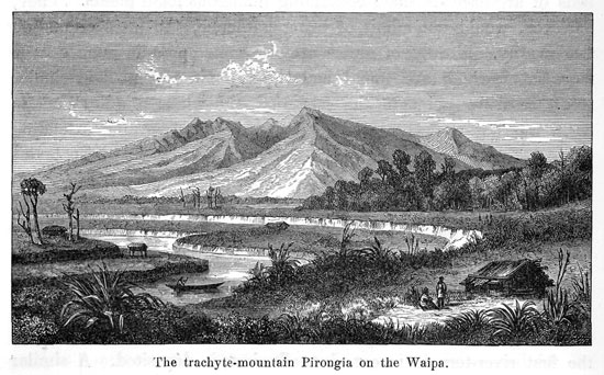
From Whatawhata we proceeded twelve miles farther up the river; and then pitched our tents on the right bank upon the first terrace of the river, at the mouth of the Mangaotama. We had closely approached the foot of Pirongia; and resplendent in the mellow radiance of the evening-sun, the mountain-mass with its many peaks and ravines, -- an ancient, dilapidated volcano, 2380 feet high, -- presented a magnificent sight. This trachyte-mountain imparts to the lower Waipa-country the characteristic
[Image of page 315]
charms of that landscape. The eye never tires of gazing at it, as it always assumes new forms from each new point of view.
March 16. -- The peaks of the Pirongia had during the night put on a cloud-cap, -- to the inhabitants of the plain a sure sign of approaching rains, which in fact were not long in coming and then lasted throughout the entire day. 6 We proceeded a few more miles up the river to a place called Rore, and there met another European, J. Cowell, whose wife was the sister of Toetoe, the chief of Rangiawhia, who was one of the party on board the Novara on her voyage to Europe. Farther up lies the old Pah Taurakohia or Matakitaki, famous in Maori history for a terrible scene of blood-shed during the wars with Hongi about the year 1825, in which more than 1000 persons are said to have perished. Further up, where the Waipa-river cuts through the spurs of the Pirongia mountain, rapids commence; the first or lowest are at the mouth of the Mangauika, a tributary from the left; the uppermost, immediately below the mouth of the Mangarewarewa and Moakurarua, two tributaries from the Pirongia-side. The latter bear the peculiar name of Whare o moti, house of Moses.
Partly owing to the rapids, over which it would not have been easy to move up the heavily loaded canoe, partly to the pouring rain, I preferred to go from Cowell's on foot, letting the natives paddle up the river by themselves as far as our next station, the Wesleyan Mission station Kopua, situated about ten miles farther up the river. About half-way, we came to the settlement of another European, named Turner, an old seaman, who 30 years ago had been shipwrecked with a small coasting-vessel at the mouth of the Waikato. He was married to a Maori-woman, who had
[Image of page 316]
borne eleven children, seven robust boys, and four pretty girls, as I had ample chance to convince myself by the specimens present in the sitting room.
At 4 o'clock I arrived at the Mission station, and together with my companions, was received by the venerable Rev. Mr. Alexander Read in his house with a most cordial welcome. The evening was passed with conversations about the manners and the relative capacities for civilization of the natives.
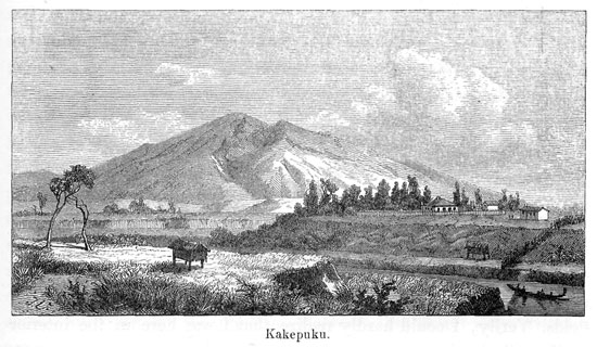
March 17. -- The Mission station is situated 30 miles from the junction of the Waikato and the Waipa, on the left bank of the Waipa at a considerable curvature of the river. Few miles to the Northwest rises the picturesque Pirongia mountain; and to the East at a distance of two or three miles upon the plain by the right bank of the Waipa, the beautiful, regular, conical Mount Kakepuku. The district is not only extremely fertile, but, as to scenery, no doubt the most beautiful portion of the Waipa country. The weather having turned pleasant again, we agreed upon an excursion to the top of the Kakepuku. The name Kake or Kakipuku is said to signify swelled neck. The top of the mountain the natives have moreover designated by the name of Hikurangi, arch of heaven. According to their views Kakepuku is the wife of Pirongia, and the smaller truncated cone Kawa rising beside the former, is in turn the wife of Kakepuku. A quarrel having arisen between the couples, they are now standing single and isolated.
Rev. Mr. Read was so kind as to accompany us on the excursion. The top can be easily reached from the missionary's house in the space of three hours. By the bank of the Waipa we met a large company of Maoris, numbering about 200 persons, assembled together for a nuptial feast. There were tents erected, and long-rows of tables placed, densely crowded with guests and heavily-laden with bread, potatoes, maize, pork, tea and all sorts of fruit. At such festivals, which are generally fixed upon for the time immediately following the gathering of crops -- it being a time of plenty, -- they feast for three whole days, and drink "in dulci jubilo." But often bitter want is felt afterwards, just before the
[Image of page 317]
new harvest. We could only with considerable difficulty manage to withdraw from the urgent invitations to partake of the feast. A canoe conveyed us over the river. On the opposite side the way leads over fertile plains to the foot of the mountain.
Past the southern foot flows the Mangawero, a river famous all over the country for its abundance of eel. Along the river we noticed numerous eel-traps, in which the natives are said to catch sometimes in one night more than a thousand eels. The water of the river is a clear mountain-water. Upon a ledge of rocks consisting of hard trachytic tuff, which extends across the bed, the river can be crossed dry-shod. Then begins a gentle slope, which encompasses like a wall the conical mountain, and is separated from the latter by swamps. This outer wall may be justly considered as a tuff-cone or tuff-crater, like those occuring with the Auckland volcanoes. The cone itself rises at an angle of 20 degrees. Blocks of a trachydolerite containing numerous pyroxene-crystals are scattered along its declivity. A convenient foot-path leads upward through the fern-bushes past a spring of 64 deg. Fahr. temperature. The top is said to have formerly been fortified and cultivated; only on the Southwest-side there is a small tract of
[Image of page 318]
forest remaining, which the chief, who is the owner of that ground, had ordered to be spared. This sylvan grove welcomed us to its cooling shade, and was moreover found to be rich in small, but also rare land-shells. Besides numerous small species of Helix, Realia (cyclostoma) turriculata Pfr. and Daudebardia (Helicophanta) Novoseelandica Pfr. are found here frequently. 7
The prospect from the top is grand; but owing to the tall bushes we were obliged to shift our position several times, to enjoy a view all around. In clear weather, the Ruapahu, Tongariro, and the Taranaki mountain, those three gigantic cones of the North Island, are said to be visible. We regretted very much, that such was not the case at this time; yet, also the nearer environs presented points enough to keep me busily mapping for several hours. The beautiful, richly cultivated country about Rangiawhia and Otawhao lay spread out before me like a map. I counted about ten small lakes and ponds scattered over the plain, and the church-steeples of these places were seen arising from among orchards and fields. Verily, I could hardly realize that I was here in the interior of New Zealand.
The height of the top I fixed at 1531 feet above the level of the sea, or at 1358 feet above the Waipa-plain. Several deep ravines runn from the top towards the foot, and two deep abysses on the top of the mountain seem to designate the old crater of the extinct volcanic cone, at the Southeast foot of which there lie trachytic cones of smaller size, the Kawa, Tokanui, Ruahine, Puketarata, and others.
On our return to the missionary mansion we had the pleasure of meeting with Mr. Williamson, the Superintendent of the province, who had just arrived here with his travelling companions from an excursion to the eastern districts of the province. The house of the missionary, therefore, was crowded with guests.
March 18. -- A pure, cloudless sky smiled upon us to-day; the atmosphere so clear, that from Mr. Read's garden the snow-
[Image of page 319]
clad giant-head of the Ruapahu could be distinctly seen looming up above the hills and mountain-terraces in the South. I beheld the mountain for the first time. In viewing it from the missionary's house, it lies to the South 7 deg. 55' East, at a distance of 80 miles. Its top appeared like a broad, snow-covered roof, and is said to be never clear of snow. Mr. Read, however, assured me, that during the week past there had been several bare patches of rock visible, and that the mountain had now, towards the end of summer, already donned a fresh robe of snow.
As I intended, before continuing my journey from the Waipa farther South, to visit also the harbours on the West Coast, and first of all, the Whaingaroa Harbour, I had the pleasure, in company of the Superintendent, of again travelling down the Waipa as far as Whatawhata, from which point the shortest and easiest road lead across the coast-range to Whaingaroa. We did not reach Whatawhata before night, and set out next morning, March 19. on our road to Whaingaroa. There I met with a little accident, as we were just on the point of starting, but fortunately without any serious consequences. As I was about to go through the plain overgrown with ferns to the margin of the river-bank I fell unawares into a pit above 6 feet deep, one of those dug by the natives close to their settlements, for the purpose of storing away potatoes. My left knee pained me considerably in consequence of the fall, and limping as I was, I could proceed but slowly. The Superintendent, therefore, who was obliged to arrive at Whaingaroa at a stated time, was soon ahead of me with his party, while I followed slowly.
The road, one of the best and most frequented New Zealand paths, leads across open fern-land, hill up and hill down to the foot of a steeply ascending range, the southern continuation of the Taupiri and Hakarimata range, and forming the boundary between the Waipa country and the West Coast. At noon we camped at the edge of the woods by a clear mountain-stream Toketoke. The passage across the mountains lay for the most part through bush, which was pregnant with the balmy fragrance of an orchidee grow-
[Image of page 320]
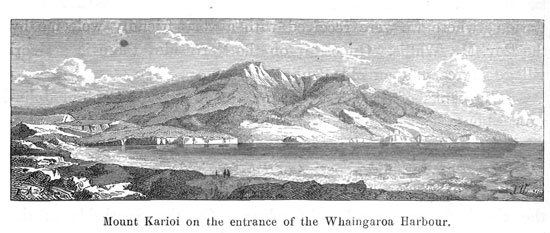
ing on forest-trees, and which was in full bloom. The highest point of the pass is according to my measurement 853 feet above the sea. The range consists of the same kind of slate, as the Taupiri peak. On the opposite declivity, upon an open place called Te kapa ama hanga, a beautiful prospect is opened over the environs of Whaingaroa Harbour. At sunset we reached the foot of the mountains, and crossed the Waitetuna River (eel-river). This is the principal river flowing from the coast-range to the harbour. A second, smaller river, emptying farther North into the inlet of the harbour, is, like the latter, called Whaingaroa. 8 The banks of the Waitetuna are formed by clay-marls of the same description as the strata at the mouth of the Waikato containing Belemnites. We had hoped to be quite near to our place of destination; but we had a long distance to go yet in the dark, besides a difficult passage across a deep creek; and it was not until 9 o'clock at night, that we arrived at the house of Captain Johnston. The captain himself was absent from home, but had made ample provisions for a hospitable welcome in case of our arrival. The comfortable quarters were the more acceptable to me, as from violent pains in the knee, which rendered me utterly unable to walk, I was obliged to keep my bed for two days, and not until March 22 had I so far recovered the use of my limb, that I was able to mount a horse, and thus proceed to Raglan, the future port-town close by the entrance to the harbour.
Whaingaroa Harbour is a narrow inlet of the sea with numerous branches, six to seven miles long, the eastern half of which is divided into two parts by a far-jutting peninsula. The Whaingaroa river empties into the northern branch; the Waitetuna into the southern. The harbour is passable only for small crafts of 60 to 80 tons, which generally anchor close to the entrance. By means of boats, however, communication is practicable far up into the
[Image of page 321]
remotest side-branches. At neap-tide, the harbour is almost entirely drained of water; broad surfaces of mud are laid bare, and only narrow channels continue to retain some water. The Maori population in the neighbourhood is estimated at 400 inhabitants; the number of Europeans, on the other hand, who have settled in this country, was stated to me as amounting to 122, among them 20 farmer-families. About a mile inside of the Heads, on the Southside, a township was founded by the name of Raglan. The place, however, numbered as yet only six or eight houses, among which, of course, a tavern and a mercantile store. Not far from Raglan, likewise on the Southside, there is a Mission station, where we were received with a very friendly welcome by the Rev. Mr. Wallis. Opposite, on the Northside, there is a Maori village Horea and an old Pah.
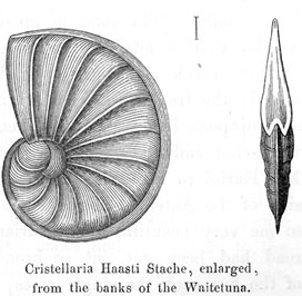
The banks of the Waitetuna in the vicinity of Captain Johnston's house consist of light-gray clay-marl of tertiary age, containing fossils. I succeeded here, in company with my friend Dr. Haast, in gathering species of Turitella, Isocardium, Natica, and Turbinolia, together with some beautiful Foraminifera;, in which the clay-beds are greatly abounding. On the Southside of the harbour basaltic hills arise, while Raglan is situated upon soft, ferruginous sand-stone, formed of quicksand. Opposite to Raglan, on the Northside of the harbour a picturesque formation of tabular limestones appears, which, corroded by the sea, present the most singular forms, such as towers of 60 to 70 feet high, walls and the like. These limestones belong to the same tertiary formation as the limestones near Drury, and are full of fossils, which, however, are difficult to knock out. On passing, from the North-head along the West Coast in a northern
[Image of page 322]
direction to a distance of some miles, the traveller arrives, behind a corner of basaltic rocks, at a very rich locality of fossils embedded in a sandy tertiary limestone. The rocks are full of large oysters and of species of Terebratula, Pecten, Balanus etc.
Viewed from the Northhead, the Karioi mountain presents itself in its full beauty as a mighty corner-buttress jutting far into the sea on the Southside of the harbour. It is a trachyte-stock like Pirongia, 2372 feet high, wood-grown from foot to top, its declivities furrowed by ravines, and with a broad, serrated top.
Along the eastern foot of this mountain our path led us on the 23d of March to the Aotea Harbour, the Superintendent returning to Auckland. The distance between Whaingaroa and Aotea is ten miles. The road is good, and cut so broad through the woods, that it admits the use of horses. When ascending from Opotoro creek along the Mata-brook the first height has been scaled, the traveller arrives at an open place in the woods where an European house stands. Then, after crossing a gently sloping wood-clad indentation of the mountain-ridge, which extends from Mt. Karioi to Pirongia, he reaches the open hills on the Northside of the Aotea Harbour. The bush upon that saddle appeared to me very beautiful and luxuriant, no doubt merely because the road had been out out so broad, that I really had a full view of the forms of the single trees, which is hardly possible on the
[Image of page 323]
ordinary bush-paths. Having been delayed on our way, we were obliged to camp in the bush, and, therefore, did not reach Aotea Bay until the morning of March 24.
The Aotea Harbour is an estuary, expanding into a shallow bay within its narrow entrance from the sea, two to three miles wide and extending about six miles into the land, which at the time of ebb becomes quite dry, save some narrow water-courses. We happened to arrive at neap-tide, and consequently had the pleasure of wading, surrounded by innumerable swamp- and water-fowls, through the mud-fields strewn with mussels and shells. Thus we arrived at the Maori-village Rauraukauera situated on the Northside, and received at the Wesleyan Mission station Beechamdale a hearty welcome from Mr. Skinner. The buildings, especially the church, presented a quite dilapidated appearance; but the more beautiful and smiling was the aspect of the apple and fig-trees and of all the lands round about the village. The school numbered only 16 children.
About 270 native and four European families are said to live by the shores of Aotea Bay. Dieffenbach, in 1841, estimated the number of natives as still amounting to 1200. The two most influential chiefs of the country are Te Kanawa, with his Christian name Kihiringi (Kissling), on the Northside of the harbour, and Te Maratua or Pinarika (Abimelech) on the Southside. The acquaintance of the former was not uninteresting to me. He was almost blind and must have already numbered over eighty years. His descent he derived from the crew of the Tainui canoe, which, as the legend goes, was stranded on Kawhia Harbour; he talked to me a great deal about wars and the numerous tribes, which in days of yore had populated the country. Upon my asking, what had become of all those people, he replied with the greatest calmness and composure possible: "we have eaten them all up," and when I requested him to write his name for me upon a sheet of paper, he wrote with the left hand and in gigantic characters, but reversed, so that the paper had to be held to the light in order to decipher the characters upon the other side. How the old man had acquired that kind of writing, I do not know.
[Image of page 324]
Small schooners of 18 to 20 tons are the means of communication between Manukau and Aotea. Larger vessels are prevented from passing in by the sand-banks in front of the entrance to the harbour. The Aotea Harbour also terminates towards the East in two creeks or livers, the Pakaka North, and the Makamaka South.
The geological features are very simple, but instructive, since the two formations, which on the Whaingaroa lie separate, can here be observed lying one above the other. The best section is exhibited at a white cliff on the Southeast side, visible at a great distance, and called Orotangi by the natives, which signifies, that here rocks fall down with a rumbling noise. At the bottom, lies grayish marl about 40 feet thick and of the same description, as on Whaingaroa Harbour, with few fossils. I found an Inoceramus and some few Pectens. Above banks of calcareous sandstone are piled full of fossils. It is the same formation, to which also the tabular limestones of Whaingaroa belong; at the neighbouring Puketoa-cliff those sandstone-banks are contiguous to the level of the sea. The fossils collected here belong to species of Pecten, Spondylus, Cuculaea, Terebratula, Pollicipes, Scalaria and Schizaster. This tertiary marl and sandstone formation forms round about the Aotea Harbour a ridge of hills furrowed by innumerable little gullies. Close by the Heads the quicksand is piled up in hills 300 to 400 feet high, and at the water-edge here and there thin lignite-beds are visible.
I reached on the same day yet the Kawhia Harbour, a distance of only four or five miles. The road to this harbour leads from the settlement Te Kawa Kawa, on the South shore of the Aotea Bay, across the fertile, richly cultivated Karikari-plateau and thence past sand-hills and small fresh-water ponds abounding in eel. With the ferry-man on the Northside of the harbour we found comfortable quarters for the night.
March 25. -- Rose early; when I stepped from the house upon the beach, the Kawhia Harbour lay before me in full morning-splendour, a large surface of water, smooth as a mirror.
[Image of page 325]
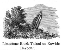
Not far from the house, by a sand-hill covered with bushes stands the memorable limestone-block, which according to the Maori-legend
is a part of the canoe Tainui, in which the first immigrants from Hawaiki came to Kawhia Harbour. The place was formerly tapu, and the Maoris, when paying a visit to the relic, keep at a respectful distance. Yet among them there seem to be some collectors of curiosities; for even from this stone block consisting of tabular limestone, and projecting slantly from the ground to a height of about four feet, all the corners had been knocked off. Close by, there are some magnificent specimens of the Pohutukaua-tree growing; and about two miles North of the Northhead, close by the sea-shore, some warm springs are said to rise, which the natives call Puias.
The Kawhia Harbour is the last extensive estuary on the West Coast. It is six to seven miles long, three to four miles wide, and intersected by numerous navigable channels, between which at low-water shallow sand and mud-banks are laid bare. The principal channels are: on the Northside, the Kawhia Channel which again is divided into three branches: the Oparau, Kauri and Awaroa Channels; in the middle, the Rakaunui Channel, and on the Southside, the Waiharakeke Channel. All these channels lead to small rivers of the same names, emptying from the East into the harbour. The entrance to the harbour is hemmed in to within half a sea-mile by a neck of land, Te Maika, protruding far from the Southside. In front of the entrance are sand-banks which admit only the passage of small vessels. The coast-navigation is carried on partly by Europeans, partly by natives. Six European families had settled down at various points of the harbour, and the number of natives has been estimated at 500 to 600. They are said to be zealous adherents of the Maori king, to place annually a certain sum of money (I was told, 136 pounds sterling) at the disposal of the king, and to have made the at-
[Image of page 326]
tempt to exact toll from the European coast-cruisers entering the harbour, and tribute from the Europeans settled among them. The original tribes have been here also dislodged and supplanted by Waikato-tribes. The present inhabitants belong to the tribes Ngatimahutu, Ngatimaniapoto and Ngatihikairo.
I was taken over by the ferry-man to Takatahi on the Southside of the harbour, where I lodged with Messrs. Yates, making excursions thence in various directions for the benefit of geological studies. Close by lived an English custom-house officer, Mr. Schultz; and we were always sure of passing a pleasant evening.
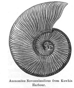
While, upon an excursion from Takatahi along the strand in the direction of the Rangitaiki Bay towards Southhead, I was examining more closely the rocky banks of the shore, consisting of steep-rising banks of shale and sandstone, which gradually slope towards East, I had the pleasure of discovering the first New Zea-
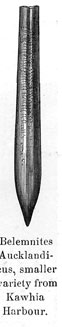
land Ammonites. But notwithstanding a long and tedious search I had to be content with two specimens, both belonging to the same species. I have called it Ammonites Novoseelandicus. It has its nearest relatives in European forms belonging to the Neocomien. A second fossil of very frequent occurrence here, a large ribbed Inoceramus, I called after my friend Haast Inoceramus Haasti. It was evident, that these shales belong to the same formation as the Belemnite-bearing beds on the Waikato; yet I searched, in vain, for Belemnites. I was the more surprised, therefore, to discover a rich locality of Belemnites, on a second excursion in an opposite direction, up the Waiharakeke Channel, at the Ahuahu Point on the Southside of the channel, not far from the Wesleyan Mission station. The cliffs are here almost 40 feet
[Image of page 327]
high and consist of grayish-brown shale, the steep-rising strata of which alternate with hard calcareous banks. Upon the mud-bank at the foot of this cliff numerous belemnite-fragments are scattered about, and after a short search among the banks complete specimens are also found. It is the same species as on the Waikato, Belem. Aucklandicus, only a smaller variety of it. To the Maoris of the neighbourhood those belemnites were well known; they told me, that their children gather the sharp stones to play with them; they called them Rokekanae, excrements of the fish Kanae (Mugil Forsteri; mullet), which they thought was in the habit of leaping out of the water and leaving those stones behind on the shore.
At the missionary station close by we found Mr. Schnackenberg, a German countryman, a native of Hanover, who was sincerely delighted at our unexpected visit, but who, we found, had utterly forgotten his mother tongue. In the garden I saw lemon-trees bearing beautiful fruits. While we were amusing ourselves with discussing the past and future of New Zealand, the chief Te Nuitone (Newton) arrived in a war-canoe, a genuine old warrior, of the number of Toas (heroes). He had just returned from a journey he had made to Taranaki for the noble purpose of bringing about, if possible, a peace between two tribes of that country who had been waging war against each other for several years past; and was in a very depressed state of mind. He expressed it as his opinion, that affairs in Taranaki were growing worse and worse, and peace was entirely out of question; on the contrary, he apprehended, that the English Government would join one party to make war upon the other. 9
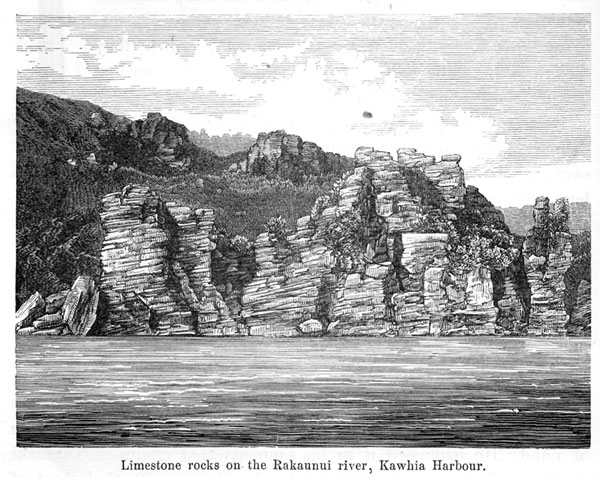
March 26th I sailed to the Rakaunui River. 10 While the whole Southshore of Kawhia Harbour consists of shales containing ammonites and belemnites; on the northern bank of the Waiharakeke, the same light clay-marl with strata of limestone-banks, that pre-
[Image of page 328]
sents itself on the Aotea and Whaingaroa Harbour, form the river-banks, and extend in nearly horizontal strata over the whole Southeast side of the harbour as far as the Awaroa river. On the Raukaunui river the limestone-banks reach the level of the water, and present along the shore picturesque rock-sceneries in the shape of towers, walls and ruins, from which circumstance the settlers have given to this portion of the Kawhia Harbour the name of "New
Zealand Helvetia." Those picturesque columnar rocks, cleft and weather-beaten in the most different shapes and forms -- now forming long and high banks, now picturesque islands and promontories -- always present new and interesting views along the winding creek, while in the valleys and gullies leading to the creek, the villages of the natives lie scattered about, and luxuriant wheat- and maize-fields greet the eye. I reckon this country among the most charming and fertile districts that I have seen upon New
[Image of page 329]
Zealand. The character of the landscape seems to continue the same far up to the steeps of the mountains; for even to heights of at least 1000 feet above the harbour, walls and crowns of white rock are to be seen emerging from among woods and bushes; hence the name Castle Hills for these mountains; the natives call them Whenuapu.
This country is noted also for its numerous caves. One of them, Te ana hohonu, the deep cave, is situated on the peninsula between the Rakaunui and Awaroa rivers close to a small Maori settlement. The entrance to it was entirely closed up by dense bushes of Koromiko (Veronica speciosa) and Tutu or Tupakihi (Coriaria sarmentosa). Likewise of the Warengarara fern (Asplenium lucidum) with its beautiful glossy leaves, specimens of a most luxuriant growth are found. After we had removed the bushes, we found a kind of natural tunnel, leading in a north-eastern direction about 100 yards, but then getting so low, that a man could proceed only by crawling. The natives assured me, that farther-on the cave grows larger and wider, containing beautiful stalactites, and then separates in three branches. However, it did not seem worth while to continue the exploration of the same. A second cave was pointed out to me as the cemetery of the Ngatitoa-tribe, to which the famous Maori chief Rauparaha belonged. It is said to be crowded with Maori corpses, shriveled and dried up like mummies. This cave, however, is, at yet, strictly tapu, and no admittance granted to it. The tertiary limestones occur also on the Northside of the Kawhia Harbour at the Tawara Bay and on the Pati river. On the latter and on the Awaroa river there are likewise places abounding in fossils of the kind, that we have already met with on Whaingaroa and Aotea. On the Southside of the Kawhia Harbour limestone forms the rugged steeps of the Castle Hills.
March 27. -- Pursuant to a cordial invitation, I spent the Sunday at Mr. Charleston's, on the Northside of the harbour. In him I became acquainted with the oldest settler on Kawhia Harbour, a Northumberlander by birth, a hardy, energetic man, who seemed
[Image of page 330]
to have been destined by Nature for the rough work of a primitive settlement upon New Zealand. During the 19 years of his sojourn upon New Zealand, he had acquired considerable wealth by trading in corn and cattle, and, radiant with proud self-consciousness, he conducted me through his splendid orchard and vegetable garden, thence through a poultry-yard teeming with chickens, ducks and geese, and finally to his meadows and pastures, where horses, cattle, sheep and pigs bore testimony of a considerable property. He expressed the wish, that my artist, Mr. Koch, would paint his house and garden, with the liberal remark, that he was not particular a to a pound or two, if only the apples in the garden were painted quite nice and red. In the afternoon neighbouring settlers with their families arrived on a visit. Likewise a native, calling himself John Wesley, holding the office of a native-assessor on Kawhia Harbour, and aping in a ludicrous manner the gentleman or dandy, had arrived with his spouse, so that the house was quite crowded. There being no scarcity of pretty young ladies gracing the social circle, and the cellar of the house harbouring excellent English ale, the evening passed off very amusingly.
March 28th I started on my return to the Waipa. Three roads lead from Kawhia Harbour across the ranges along the southern foot of the Pirongia to the Waipa-valley. The traveller will choose one road or the other according to his point of starting on Kawhia Harbour or his place of destination on the Waipa. The southern route is the Awaroa-road. It leads from Awaroa Creek through a romantic limestone, and sandstone country and is connected with the roads to the upper Mokau district. But in order to arrive at the Mission station Kopua on the Waipa, the other two roads are preferable. The Kauri-road, starting from the Kauri Creek, appears to be less woody and mountainous, than the Oparau-road, and is therefore specially to be recommended to horsemen, while the Oparau-road is the shortest and most direct route for pedestrians, but offering difficulties to horses, since two very deep and steep ravines are to be passed. Captain Hay and the photo-
[Image of page 331]
grapher, who had started from Takatahi on the Southside of the harbour, chose the Awaroa-road; whilst I with Haast and Koch took the Oparau-road.
Mr. Charleston having kindly placed his boat at our disposal, we set out with the beginning of spring-tide. The Oparau-river empties into the Kawhia Harbour between the peninsulas Tiritirimatangi and Otururu. A close acquaintance with the channels between the extensive sandbanks is necessary in order to reach the river. Our adventurous pilots set us repeatedly upon the sand, before arriving in the narrow river-bed. We could proceed only a short distance farther up, and then landed close by a mill. The mill is called the Mangapapa-mill, after a small brook, on which it stands, and belongs to a Frenchman. The country on the Oparau is extremely fertile and well cultivated. The soil consists of decomposed trachytic tuff and conglomerate, extending from the trachyte-stock of the Pirongia as far as the Eastside of Kawhia Harbour. We proceeded a few more miles up-hill, and, when evening had set in, we pitched our tents upon a potatoe-field at the edge of the bush.
March 29. -- The night was star-light and very cold. Early in the morning I saw, for the first time during our journey, frost upon the ground. The road carried us higher and higher up into the mountains, now through bush, now across open heights covered with fern, from which a charming view is had of Kawhia Harbour, and a retrospect upon the country just passed through. After crossing several mountain-streams, the traveller enters into the bush, through which he ascends to the mountain-ridge forming the water-shed between the West Coast and the Waipa. On the right of the road, after having reached the highest point of the pass (1585 feet above the sea), there stands a gigantic Rata tree (Metrosideros robusta), about 100 feet high. The root-stock forms a cone 8 feet high; then the trunk begins, the circumference of which at a height of 4 feet above the root-stock amounts to 46 feet 8 inches. The tree appeared to be perfectly sound, and was entirely overgrown with parasitical Bromeliaceae. In the bush I gath-
[Image of page 332]
ered a great number of beautiful mosses and ferns, especially various species of Hymenophyllum, with which the mammoth-trunks were covered all over. The mountain-ridge itself is a southern spur of the 2381 feet high Pirongia range, and consists like the latter of volcanic rocks, especially of trachydolerit with crystals of pyroxene, and of basalt. In the dusky woods and gloomy ravines of this mountain-stock the Kiwi (Apteryx Mantelli) and the Weka (Rallus australis) are said to be still quite frequent. The natives told me also of a large kiwi resembling a cassiowary, which they said was sometimes found here.
From the height of the pass we were obliged to descend into a deep, wild ravine, called Ngutunia. Hence once more up-hill to a second, broader ridge, and for about four miles through the dark bush. About 5 o'clock p. m. we reached the end of the woods -- and there, radiant with the soft light of the evening sun, lay before our wondering eyes the landscape on the Waipa, With pleasure we greeted once more the Kakepuku and the missionary's house, which was blinking up to us so cheerfully. But, although it appeared quite near, we had yet a long distance to go. A second, deep ravine had to be passed, then after a walk over extensive fern-heaths, we came to a tributary of the Waipa, and it was not until 9 o'clock in the evening that we reached again our hospitable quarters at Mr. Read's.