CROZET'S VOYAGE.
[Image of page 5]
CROZET'S VOYAGE.
In the course of his voyage round the World in 1768 and 1769, M. De Bougainville had brought to France a native of Taity, an island in the South Seas. This Indian was the object of much interest in Paris on account of his frankness and of his excellent natural qualities. The Government sent him to the Isle of France with orders to the Administrators there to take measures to secure his return to his native country.
M. Marion du Fresne, the Master of a Fireship, 1 and a smart
[Image of page 6]
sea-officer, seized the opportunity to distinguish himself by making a new voyage and by making discoveries in little-known seas. He offered to carry the Indian to his native country at his own cost. He asked for one of the King's storeships to be attached to his own vessel, offering to pay all the expenses of the expedition himself.
The Administrators 2 of the Isle of France advanced him the necessary sums for the armament of these two vessels, and M. Marion gave surety for the payment of these loans. Although by this arrangement the whole expedition came under the control of M. Marion, the Governor of the Colony gave him the fullest instructions concerning the lands he was to go in search of and on the physical and moral observations he was to make in the course of his voyage. It was proposed he should advance sufficiently to the south in order to try and discover the islands, or the continent, which it was supposed were to be found in this southern portion of our globe, the Governor of the Isles of France and Bourbon being particularly anxious that the most northerly portions of this supposed land should be discovered, as they
[Image of page 7]
PREPARATIONS FOR DEPARTURE.
would be nearer to the colonies and under a more temperate climate than the more southern portions. He hoped they would find timber for masts, and a variety of necessaries which the Isle of France, so far distant from any chief seaport, could only obtain at the expense of great trouble and cost. The Governor pointed out to M. Marion that during the season which commences in November and ends in April it was impossible for the ships of the Isle of France to be employed usefully; that they had to be laid up in port, where they were not even safe from storms, and that they remained there at an expense to the colony; that this stormy season at the Isle of France was the most favourable for starting and exploring the southern lands, and that great advantage would accrue to the Isles of France and Bourbon from the discovery of these lands. M. Marion thoroughly understood the soundness of these views and desired most eagerly to acquire glory in making discoveries which he foresaw might give a new career to the colony in which he owned property. The Court of France had just sent M. de Kerguelen 3 to the Isle of France with permission to visit this part of the world, and if possible to complete by his discoveries a knowledge of the earth in all its inhabited or habitable parts. It was important in order to carry out the views of the Court on this point to interest M. Marion in them,
for he was leaving at a time of the year apparently more favourable than that in which M. de Kerguelen could depart,
[Image of page 8]
and who was moreover to attempt his discoveries by quite a different route.
In consequence of these arrangements, M. Marion chose the most experienced officers in the Colony, and he engaged me as one of them to ship as his second in command.
The native of Taity, named Mayoa, embarked with M. Marion on the 18th October, 1771. The two vessels, namely the Mascarin commanded by M. Marion, and the Marquis de Castries commanded by the Chevalier Duclesmeur, first of all put into port at the Isle of Bourbon. The Indian was there attacked by small-pox, of which he had probably taken the germs with him from the Isle of France, where this epidemic was making cruel ravages at the time of the departure of the vessels.
For fear of introducing into the island a disease which is looked upon as almost as dangerous as the plague, M. Marion was obliged to depart from the Isle of Bourbon, and anchored in the Bay of Fort Dauphin in Madagascar, in order to let the disease run its course, and so as not to carry it with him to the Cape of Good Hope, where he was obliged to go in order to complete his outfit. However, on the morning of our anchoring in the Bay of Port Dauphin, the Taitian died, and an affidavit recording his death was made.
The chief object of the expedition having thus become void by the death of the Indian whom we were to carry back to his native country, it would perhaps have been more proper under the circumstances to have taken the vessels back to the Isle of France, and there to have paid them off for employment in some other object. But M. Marion's desire to make useful discoveries, and to distinguish himself by a new voyage, overbore all other considerations.
We therefore started for the Cape of Good Hope, where in a few days we completed the provisioning of the two ships for an eighteen months' cruise. This being accomplished, we set sail from the roadstead on the 28th of December, 1771, and at eleven o'clock in the morning M. Marion directed his course towards the South in order to discover the Southern Lands.
This search had already occupied M. Losier-Bouvet, who in
[Image of page 9]
THE DEPARTURE.
1737 saw a Cape which he named Cape Circumcision. But the land discovered by this able navigator was apparently not the same where Captain Gonneville had touched in 1503. 4 The route followed by M. Bouvet indicated to M. Marion that he must look for these lands to the east of the meridian, which passes through Madagascar.
Nothing remarkable happened from our departure from the Cape of Good Hope until the 7th January, 1772, when our latitude observations showed us that we were in the parallel of the islands Dina and Marzeven. These islands are marked on the charts of Van Ceulen 5 in lat. 40 to 41, and I do not know why our modern hydrographers do not mention them, for they should not ignore that several Dutch vessels knew them thoroughly, and I have even been assured that these islands are well wooded and watered. 6
Our longitude by reckoning was, on the 7th of January, 20 deg. 43' east of Paris. Next morning we saw a large number of gulls, and the sight of these birds showed us we were not far from the islands we have just mentioned. The sea had changed much: it was rough now with a violent wind. We left these parts on
[Image of page 10]
the morning of the 9th January, considering that the search for the Southern continent should alone occupy our attention. On the 11th I took a latitude observation, 45 deg. 46'; the reckoning for the longitude was 28 deg. 46' east of Paris. Although in the Southern Hemisphere the month of January corresponds to the month of July in the Northern Hemisphere, yet we experienced the severest cold in the height of summer and in a climate which appeared to be placed in the temperate zone. As snow fell almost the whole time we were in these parts, we could not attribute the cold we suffered to any sudden change of weather.
On the 12th January we saw some poules mauves, 7 gulls, sea-wolves, 8 and sea-weed. At six o'clock in the evening M. Marion sounded and at 130 fathoms there was no bottom. At eight o'clock in the evening we clewed the mainsail and continued during the night under the two maintop-sails and the fore-sails. The sea was fairly fine and the weather was foggy. I noticed that at sundown the gulls and other birds flew towards the east and east-south-east, a fact which announced lands in that direction.
DISCOVERY OF SOUTHERN ISLANDS.
At six o'clock in the morning of the 13th January we saw, returning from the west, gulls, poules mauves, and some other birds, which never fly far from land. We continued our east-south-east course and saw many sea-wolves and much seaweed, with which the sea was covered. On sounding we found no bottom at 130 fathoms.
At two o'clock in the afternoon we were surrounded by a fairly thick mist and we also had some rain. The sea. was fine and smooth, but there was a swell from the west. At four o'clock the wind freshened. We unreefed the main-sail and the sea once more changed. At half-past four we sighted land which extended four to five leagues from west-south-west to west-northwest. As the fog was thick and we might be mistaken, we sounded and found bottom at 80 fathoms, with coarse sand mixed
[Image of page 11]
THE LAND OF HOPE.
with coral. At the same time we saw also very clearly more land to the north.
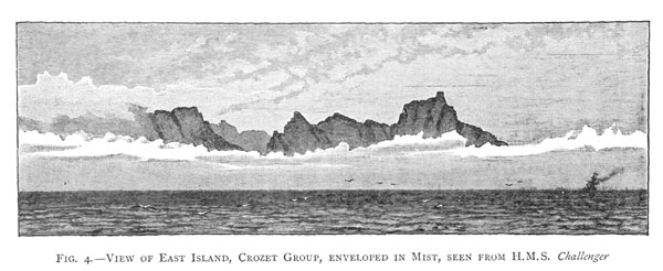
Continuing our course and following the bearing of the first land, the centre of the middle portion of which was to the west of us, we found we had coasted along it three leagues further during the night: we had in fact followed its lay until we saw it behind us. Before seeing it I had noticed that from midnight until four o'clock in the morning, the sea had been smooth and calm, as if it were sheltered by land, and was shallow. As soon as we had sighted this first land, which now remained behind us, I took bearings and hastened to sketch the view for fear that the fog would not let us see it for any length of time. We only saw about six or seven leagues of its side view, but we did not see it end to the W. N. W. nor to the S. E., so that it is quite possible this land may extend very far, and may possibly form a part of a southern continent. The land appeared to rise very high, covered with mountains doubled and trebled one on top of the other. Suddenly the fog robbed us of our view. M. Marion named it Terre d'Esperance (Land of Hope), because its discovery flattered us with the hope of finding the southern continent we were in search of. It was too foggy for us to find out whether the country was covered with vegetation or whether it was inhabited.
At the sight of these lands to the west and north, and all the more as we appeared to see land towards the south-east, M. Marion feared to be caught in a bay, and directed his course to the north. The wind then rose and the sea became very rough, and although we tried hard to pass this island to leeward, we were ultimately forced to pass it to windward. Before the bad weather set in I had taken bearings, and had drawn a sketch of the island, the north-western portion of which we had not seen. In sailing along this island I noticed a cove on its north-eastern part, in which there appeared to be a large cavern; around this cave we could see a multitude of large white spots, which in the distance looked like flocks of sheep. 9 Had time permitted it,
[Image of page 12]
we thought we might have found anchorage opposite this cove. I believed I saw a waterfall coming down the mountains. In doubling the island we discovered three islets, of which two were in a recess formed by the shore, and the third was at its most northern point. This island appeared barren, and was about seven or eight leagues in circumference, and without vegetation, its shore fairly secure and without danger. M. Marion called it L'ile de la Caverne (Cavern Island). These two southern lands 10 are situated in lat. S. 46 deg. 45', and long. 34 deg. 31' E. of Paris, and half a degree to the east of the route followed by Bouvet in search of the lands of Gonneville.
On the morning of the 14th January we returned to look for the first Land of Hope, which we had discovered the night before, and which the mist, together with the wind, had prevented us knowing better. We approached to within six leagues, and sounded again, finding bottom at 80 fathoms, with fine sand mixed with detritus of shells. On approaching the land, I noticed on its north-east side a cove formed by low and abrupt points. We were not sufficiently close to be able to ascertain whether this land was wooded: it was covered with mist, but it appeared very green to us; the mountains were very high, and the tops were covered with snow. These mountains are high enough to be visible at sea 12 leagues off. We were about to look for an anchorage in the cove before us, and to survey this land, when, while preparing to sound, our two vessels ran foul of each other. The Castries lost her bowsprit and fore-sails. We lost our mizenmast, the taffrail of our poop, our starboard gallery, and several hen-coops. This accident quite upset our plans, but luckily the wind had fallen and the sea was now quiet. We sent three small masts to the Castries with carpenters to rig them up. The repairs occupied us three days, during which we had favourable weather, but the wind having then become very violent, we abandoned our discovery, and continued our voyage along the 46th south parallel.
I cannot help remarking here that the thick and almost con-
[Image of page 13]
THE COLD ISLANDS
tinued fogs which reign in these parts are a very great hindrance to those in quest of discoveries, and render navigation extremely dangerous, and considering the state of the Castries, we dared not venture further south. 11 Having seen the mountains of the Land of Hope covered with snow, it was most probable that a few degrees further south we would have been surrounded with ice, as was the case with M. Bouvet.
Since we sighted the first lands, which we were now leaving behind us, we met incessantly with kelp, gulls, divers, penguins, and sea wolves. Up to the 24th of January, when we saw some of the new lands, we had nothing but fog, rain, and excessive cold. These lands appeared first of ail to be two islands and I drew a sketch of them eight leagues off; later on they looked like two capes, and we thought we could see that they were joined by land. A moment later fog and night deprived us of the view. They are situated in 46 deg. 5' lat. S. and in long. 42 deg. E. of Paris by dead reckoning. M. Marion called them the Iles Froids (Cold Islands). 12
We made little headway during the night, and keeping together, and in the same parts, proposed to make a better survey of the lands in the morning; but on the 23rd we lost sight of them. We had apparently wandered during the night, the weather being foggy and rainy, and we found ourselves in one of those currents which run strongly north and south.
The same day, 23rd January, we changed our course to the east. The Castries, which followed us, signalled that land was in sight. It turned out to be a very high island, which appeared to me to end in a big cape. I took bearings to E. S. E. at a distance of about ten or twelve leagues. We tacked about in order to get near to this land, but when we were about six or seven leagues off a thick mist came down, and, lasting about twelve hours, robbed us of the view. M. Marion did what he could in order to get near the land, but our crews could only work with difficulty on account of the continual rain and cold, for they were not sufficiently warmly clad to withstand a
[Image of page 14]
climate in which the summer is much severer than is the winter on the shores of France. A big iceberg which we saw on that day, at about five o'clock in the evening, can give one an idea of the cold we experienced.
At three o'clock in the morning of the 24th we saw again the same island which we had first discovered the previous day. There was little wind at the time, the sea was however rough, but it was less misty. M. Marion ordered us to approach it and circumnavigate it. I saw the island very distinctly at two leagues off. It was round and so high that in fine weather it could be seen 20 leagues off. The summit of the mountains was covered with snow.
At nine o'clock in the morning we perceived to the S. E. another island, which appeared to me even higher than the one along which we were coasting. This island was also round, more mountainous, but smaller than the first island; we called it Ile Aride (Barren Island). These two islands lie East and West of each other at a distance of about nine leagues from cape to cape. At eleven o'clock M. Marion had a boat lowered and ordered me into it in order to go and take possession, in the name of the King, of the larger of the two islands, which is situated in latitude 46 deg. 30' S. lat., and by reckoning long. 43 deg. E. of Paris. M. Marion called the island the Prise de Possession. This was the sixth island which we had discovered in these southern regions. 13
LANDING AT ONE OF THE AUSTRAL ISLANDS. --OBSERVATIONS TAKEN ON THIS ISLAND.
My first care on setting foot on shore was to deposit, according to custom, the bottle, which contained an account of the act of taking possession, on the top of a pyramid about 50 feet above sea-level and formed of large rocks piled one on top of the other. The spot where I landed was absolutely stony. I mounted an eminence from whence I saw snow lying in several
[Image of page 15]
[Image of page 16]
valleys: the land seemed barren and was covered with a very fine small grass. I found several of those coarse plants which are called ficoides, very much like those which are so common at the Cape of Good Hope. On returning to the shore, I noticed a small rush resembling grass and some amaranthus; the rocks were covered with moss and lichens; the shore was covered with a sort of rush about a foot high, very similar to that which is found at the Cape of Good Hope. The sea-weed around the shore was of an extraordinary size and had very large leaves. I could not find a single tree or shrub on the island, and I did not remain long enough to find fresh water, but appearances seemed to indicate that it could be found in the valleys which I had perceived from the eminence I had climbed.
As this island is continually exposed to the ravages of the stormy westerly winds which blow throughout the year in these regions, it does not appear to be habitable. I only found sea-wolves, penguins, petrels, envergues, cormorants, divers, and every variety of aquatic bird which navigators meet with in the open sea when they double the Cape of Good Hope. These animals, which had never seen men before, were quiet and allowed themselves to be captured by hand. The female birds quietly hatched their eggs, others fed their little ones, and the sea-wolves continued their bounds and their games without seeming the least scared by our presence.
I was surprised to see a white pigeon, which had no doubt strayed from some neighbouring land, and it seemed to me one might well argue that we were not far off from a big country which produces the proper seed-food for this bird. Meeting with a very big iceberg in the middle of this temperate zone helps to support this opinion. The route taken by M. Bouvet could now no longer stand in the way of our looking for the lands of Gonneville in these regions. I have already observed that M. Bouvet after having discovered Cape Circumcision in lat. 55 deg. was obliged to alter his course northwards and was unable to continue his search beyond the 32 deg. E. of Paris. From this point he had gone northward to strike the Isle of France.
[Inserted unpaginated illustration]
[Image of page 17]
ON THE WAY TO NEW HOLLAND.
Our position was now favourable for the discovery of the southern continent if only we could have advanced in a southeasterly direction; but unfortunately the state of the Castries since she was dismasted did not allow M. Marion to follow out his otherwise well-matured plans.
CONTINUATION OF THE VOYAGE.
After leaving the island Prise de Possession, we followed latitudes 46 deg. and 47 deg., and were in a continual fog, which was so thick that we were frequently obliged to fire off our cannons in order to save ourselves from collision. It frequently happened that we could not see the quarterdeck motions from the forecastle. Seaweed, penguins, sea-wolves, and gulls with grey stripes were seen every day.
On the 2nd of February we were in lat. 47 deg. 22' S. and 62 deg. long E. [of Paris], that is to say, 1 deg. 18' to the north of the southern lands (discovered on the 13th of the same month by the King's store-ships La Fortune and Le Gros Ventre), 14 and thirty-one days after our first discoveries in this part of the world. Had it not been for the accident to the Castries, we should have touched them more to westward, and there is every reason to believe that we would have found the lands seen by Gonneville, which must be more to the west and of easier approach than those seen by MM. de Kerguelen and de Saint Alouarn. 15 The sea-wolves, the sea-weed, the birds we saw every day, and the thick fog we met with when the wind was in the north, informed us of a neighbouring land to the south of our track. On the 10th February we were in lat. 45 deg. 36' S. by dead reckoning, in long. 81 deg. 30'. On taking lunars I found we were nearly in longitude 90 deg. E. of Paris. On that day we changed our course and directed our route towards the southern portion of New Holland known as Van Diemen's Land. We met with nothing remarkable until we sighted this country on the 3rd of March. I
[Image of page 18]
calculated we were then in lat. 42 deg. 56' S. and long. 146 deg. 20' E. of Paris.
The chart will give an exact idea of the track we followed until we anchored in the sound named by Abel Tasman Frederic Henry Bay, and which according to this navigator is situated in lat. 43 deg. 10' south.
ANCHORING OFF VAN DIEMEN'S LAND, DESCRIPTION OF THE COUNTRY, OBSERVATIONS UPON ITS INHABITANTS.
As soon as we had anchored, in 22 fathoms, on a grey sandy bottom, we lowered the boats and quickly perceived about thirty men seated on the shore. This part of New Holland 16 promised us much from the beauty of the landscape which met our view. From the fires and smokes which we had seen day and night, we inferred that the country was thickly populated.
The next morning the gigs and longboat were sent ashore armed, and some of the officers, marines, and sailors landed without any opposition. The aborigines showed themselves agreeable to our landing, collected firewood and made a sort of pile. They then offered the new arrivals some dry lighted boughs and appeared to invite them to set fire to the pile. We did not understand what they meant by this ceremony, but we lighted the pile; the savages did not appear at all astonished at this, and they remained round us without making either any friendly or hostile demonstrations. Their women and children were with them. The men as well as the women were of ordinary height, black, with woolly hair, and men and women were all equally naked. Some of the women carried their children on their backs, fastened by a rush cord. The men were all armed with pointed staves and with stones, which appeared to us to have cutting edges similar to iron axe-heads.
We noticed that these savages had generally small bilious eyes, full mouths, very white teeth, and flattened noses; their
[Image of page 19]
THE VAN DIEMEN'S LANDERS.
hair, like that of the wool of Kaffirs, tied in peppercorn knots [noues par pelotons] and powdered with red ochre; the men had small natural parts and were not circumcized. Several amongst them had a sort of cicatrice on the skin on the chest. They appeared in general to be thin, fairly well made, with broad chests, and the shoulders well thrown back. Their language seemed to us very hard and they seemed to draw their voices from the bottom of the throat.
We endeavoured to gain their good will by means of presents, but they rejected with disdain all that we offered, even iron, looking-glasses, handkerchiefs, and pieces of cloth. They were shown fowls and ducks, brought from the vessel, in order to make them understand that we wished to buy the like from them. They took these animals, which by their action they showed to be unknown to them, and threw them angrily away. We had been examining these savages for about an hour when M. Marion landed. One savage stepped out of the group and offered him, the same as previously to the others, a firebrand, in order to light a little wood pile. The Commander, thinking that this was a ceremony intended to prove that he had come with pacific intentions, did not hesitate to light the pile, but it immediately appeared that this was all wrong, and that the acceptance of the brand was an acceptance of a defiance, or a declaration of war.
As soon as the pile was lighted, the savages retired precipitately on to a hillock, from which they threw a shower of stones, by which M. Marion, as well as an officer who was with him, was wounded. We immediately returned the fire and re-embarked. The gigs and longboats coasted along with the object of landing in the middle of the bay on a spot we had sighted where there was no neighbouring height from which those who landed could be molested. The savages then sent their women and children into the woods and followed the boats along the shore, and when we wished to land they opposed our doing so. One of them uttered a fearful cry, and the whole mob immediately threw their pointed sticks [spears] at us, by means of one of which a black servant was wounded in the leg; the wound was
[Image of page 20]
not serious, and the ease with which it was cured proved that these wooden javelins were not poisoned. As soon as they had thrown their javelins we answered by a fusilade, which wounded several, and killed one of them, whereupon they immediately fled into the woods, howling fearfully, and carrying with them those who, being wounded, could not follow them. Fifteen men armed with guns followed them up, and found at the outskirts of the forest one of the savages dying from the gunshot wound he had received. This man was five feet three inches high, and had his chest gashed like that of the Mozambique Kaffirs; he seemed black, but on washing him we found that his natural colour was reddish, and that it was only smoke and dirt that made him look so dark.
After the flight of the savages M. Marion sent two well-armed and officered detachments to look for fresh water and timber suitable for re-masting the Castries. The detachments scoured two leagues inland without meeting with either inhabitants, fresh water, or the timber.
We remained six days in Frederic Henry Bay, during which time we did not cease making vain search for fresh water. The land here is sandy like that at the Cape of Good Hope; it is covered with brushwood and small trees, from most of which the bark had been torn by the savages, who make use of it for cooking their shellfish. We found traces of fire everywhere, and the ground seemed covered with ashes. In the midst of these trees despoiled of their bark and mostly burnt at the foot we noticed a sort of pine not so high as ours, which appeared well preserved, probably because the savages gained something useful from it, and therefore did not maltreat it as they did the others. It seemed to us that in going further away from the sea-coast and thus penetrating deeper inland, we should find these same pines in the valleys, but tall and thick enough for making into ships' masts.
In those parts from which the vegetation had not been burnt off, the soil was covered with grass and brake, similar to that in Europe, and also with sorrel. There was little game, and we presumed that the fires made by the savages in this place had
[Image of page 21]
DEPARTURE FOR NEW ZEALAND.
driven them inland. Our hunters met a tiger cat, and found several holes like those in a warren; they killed some ravens similar to those in France, some blackbirds, thrushes, turtle doves, a parrokeet resembling a South American one in plumage with white beak. They killed all sorts of sea-birds, especially pelicans, and a black bird with red beak and feet, and which Abel Tasman mentions in his journal.
The climate of this southern portion of New Holland seemed very cold to us, although we were there in the middle of summer, and we could not understand how the natives could exist there in their naked state. What appeared more extraordinary to us was that we found no indication of houses, only some break-winds, rudely formed of branches of trees, with traces of fires near them. By the considerable heaps of shells which we met with from time to time, we judged that the ordinary nourishment of the savages consisted of mussels, pinna or wing shell, scallops, chama or heart cockles, and other similar shellfish.
We caught chats-de-mer, red fish like gurnets, cod, wrass, large quantities of very big rays, and many small fishes which were new to us. Our sailors caught many cray-fish, lobsters, and very big crabs; the oysters were very good and abundant. The collectors picked up star-fish, sea-urchins, scallops with long and spiny scales, rouleaux, olives, cornets, and several rare and very beautiful shells.
During our sojourn in this bay I made several longitudinal observations and found it to be situated in longitude 143 deg.E. of Paris. I observed its latitude at 42 deg. 50' and took bearings.
It is remarkable that in coasting along Van Diemen's Land we met with very bad weather on the western coast, but on the eastern coast we found a clearer sky and more tractable winds.
DEPARTURE FROM NEW HOLLAND FOR NEW ZEALAND.
M. Marion, seeing that we were losing time in looking for water in a country as wild as its inhabitants, decided to set sail for New Zealand, where he hoped to find the water we were in want of, the necessary timbers for re-masting the Castries
[Image of page 22]
and the possibility of caulking the Mascarin, which was leaking badly.
On the 10th March [1772], we cleared Frederic Henry Bay and set sail for New Zealand, where we arrived on the 24th of the same month, without anything remarkable having occurred in the meanwhile.
New Zealand was discovered by Abel Tasman in 1642, but this Dutch navigator had in fact only discovered one particular spot. This portion of the southern lands has been visited lately by Captain Cook and M. de Surville. It is a strange coincidence that an English and a French vessel should have approached this country at the same time. M. de Surville had been in a bight, which he called Lauriston Bay, while the celebrated Captain Cook bore down on the two points which form the entrance to the very bay in which the Frenchmen were anchored and which he for his part called Double Bay. It is very surprising that Captain Cook did not learn from the savages of New Zealand, whose language he understood, of the arrival on these shores of a French transport, as he had moreover anchored once 20 leagues to the south and once 8 leagues to the north of the French vessel.
As soon as I obtained information of the voyage of the Englishman, I carefully compared the chart I had prepared of that part of the coast of New Zealand along which we had coasted with that prepared by Captain Cook and his officers. I found it of an exactitude and of a thoroughness of detail which astonished me beyond all powers of expression, and I doubt much whether the charts of our own French coasts are laid down with greater precision. I think therefore that I cannot do better than to lay down our track off New Zealand on the chart prepared by this celebrated English navigator. We landed at the foot of the high mountain named on this chart Mount Egmont. We named it Mascarin Peak, after our vessel. This peak is situated in latitude 39 deg. 6' S. and 164 1/2 deg. E. of Paris. Captain Cook fixes this peak a few degrees more to the east.
We took this mountain for the cape which forms the Southern entry of Massacre Bay, to which Tasman gives an extent of
[Image of page 23]
THE ISLES OF THE THREE KINGS.
40 leagues. 17 We approached to within a league and a half of the shore, in order to reconnoitre, and saw some men and several fires. This mountain appeared to rise from the sea, and we judged it to be as high as the Peak of Teneriffe. The coast here is very steep, and we found a coral and stony bottom at 80 fathoms, about a league from land. M. Marion, fearing to be windbound here, stood off, and on 31st of March we returned to take bearings in latitude 3 6 deg. 30'. From there we coasted along, sailing towards the north in quest of the Isles of the Three Kings. 18 The coast could be approached closely, there being deep water all along, and we sailed about one to three leagues off and found bottom at 26 to 40 fathoms.
While sailing along we were often attacked by squalls from the N. to the W. which obliged us to stand off. Finally on the 4th of April, at 9 o'clock in the morning, we perceived the islands, which from their position we judged to be those of the Three Kings. On the evening of the 5th of April, when we were close to these islands, we were again troubled with squalls, which obliged us to stand off. On the morning of the 13th we got to within a league of the islands and saw several men, who in the distance looked very tall. We noticed several groves of bushes which looked pleasant, but we were unable to discover the stream mentioned by Abel Tasman nor even a good landing place. All these islands may perhaps cover together an extent of about four leagues; the biggest was grassy and appeared inhabited; the others, six in number, were only barren and steep rocks.
Having made several vain attempts to land on the largest of these islands, we returned to the mainland about ten to twelve leagues off. On the 15th of April we made for land at the N. E. point of New Zealand, and to which Captain Cook in his
[Image of page 24]
charts gives the name of Cape Maria Van Diemen. We dropped anchor on the 16th in a cove situated in the most northern part of New Zealand, but where the ground did not hold well. We immediately sent a boat on shore in search of water at a spot where there appeared to be the mouth of a stream, but hardly had the boat reached the shore when a violent wind arose and the sea became very rough. The vessels dragged their anchors and we were both obliged to drop a second anchor. The boat had much difficulty in regaining the ship, and for fear of accident we had it hauled up at once. We then spent a very uncomfortable night. At daybreak the two ships were driving on to the land, so that we were obliged to set sail and abandon our cables and anchors. The wind was in the N. E., and should it have veered to the North, we should have had great difficulty in getting out of this cove.
After having tacked about to get clear of the shore, we returned to this same cove on the 26th and picked up our cables and anchors. On the 27th we got out again in search of a better anchorage. I noticed that along this shore there was a current of a league an hour, which during flood tide has an easterly course. On getting out we tacked to East and South. On 3rd May we sent a boat ashore to the east of a cape, which we called Cape Quarre on account of its shape, and which Captain Cook called Cape Brett.
When about two leagues off this cape we saw three canoes approaching us. There was little wind at the time and the sea was calm. One of the canoes, containing nine men, came close to the ship; so we made signs to the men to come on board, and sent them several nicknacks to encourage them. They came with some uneasiness and appeared not to be quite without fear when climbing the ship's side. M. Marion showed them into the chart room and gave them some bread, first of all he ate some, and then they followed suit. The liquor which was given them they drank with every sign of disgust. They were induced to take off their cloths, and instead of these shirts and trousers were given them, which they seemed to put on with pleasure. We showed them various implements such as axes, chisels, and
[Image of page 25]
THE NEW ZEALANDERS.
adzes. They appeared very anxious to possess these, and made use of them at once in order to let us see that they understood their use; these articles being given them, they went off shortly afterwards highly satisfied with their reception. As soon as they had got some distance away from the ship, we saw them take off their shirts and trousers in order to put on their former clothing, putting aside those we had given them. They then approached the other canoes, of which the occupants had not dared to accost us; they seemed to reassure the latter (and to be inducing them to go and see us), who then came on board without showing the slightest signs of fear or distrust. There were two women amongst them; we gave them some biscuits and some other nicknacks.
In the evening the wind having risen, the canoes returned ashore, but five or six of these savages remained on board of their own free-will. We gave them food and drink, they even supped with us, and ate with good appetite of all our dishes, but they declined to drink our wine or our liquor. They slept on board, we arranged beds for them in the saloon, and they slept well without showing the slightest distrust. They were, however, watched during the whole night. Amongst these savages their was one of their chiefs named Tacouri, of whom we shall have occasion to speak later on, and who showed great uneasiness every time the vessel turned from the shore in tacking about while waiting for the boat which had gone ashore in the morning.
The boat returned at eleven o'clock at night, and the officer in charge reported having found a bay round which there was a very considerable village which extended considerably inland, and where there appeared to be a good port, cultivated lands, fresh water, and wood. On the 4th of May, M. Marion sent two boats ashore, and we obtained the services of one of the savages to go with them and to point out to our people the places where they could water. The savage went willingly, and the boat started in quest of this cove. At 4. o'clock in the afternoon the boats returned with the water, and the officers reported having found good anchorage in this bay at 19 and 20 fathoms. They
[Image of page 26]
brought with them two other savages besides the one who had piloted them, and reported they had been received on shore by a large number of canoes, in which there were many men and women who were very friendly. That same day we anchored amongst the islands, and remained at anchor there until the nth of the said month, when we sailed for a safer port which our boats had discovered on the 6th, but which, on account of contrary winds, we had been unable to get into sooner. Captain Cook has called this port the Bay of Islands.