Pictorial Illustrations of New Zealand
[Image of page 1]
Pictorial Illustrations of New Zealand
THE principal islands of New Zealand are three in number, stretching in a direction from the north towards the south, or between the latitudes of 34 deg. 30' and 47 deg. 10' south, and 166 deg. 5', and 179 deg. east longitude from the meridian of Greenwich. The island at the southern extremity is called Stuart's Island, or New Leinster, and is of very limited extent compared with the others, with scarcely any inhabitants. The Northern, or New Ulster, where the natives are principally concentrated at the present time, is considered the most important island. It is densely occupied, comparatively speaking, by aborigines, the climate in these latitudes being more congenial to their taste and habits. The Middle Island, or New Munster, is also of large extent, but almost without native population: the southern extremity being cold, somewhat resembles the emigrant's home. The snow frequently lies for weeks together on the ground during the winter. New Zealand may therefore be said to present a choice of climates to the colonist, which will be duly appreciated when the country becomes eventually settled.
The entire length of New Zealand equals a distance of above 1200 miles. It has been calculated to contain 122,582 square miles, or 78,452,480 acres, --viz.
New Ulster, or the Northern Island.....31,174,400
New Munster, or the Middle Island.....46,126,080
New Leinster, or the Southern Island.....1,152,000
Total... 78,452,480 acres.
The lowest estimates make New Zealand 80,600 square miles, or 51,584,000 acres. The systematic colonization of these islands was commenced in the month of September, 1833, by the New Zealand Company, and after due consideration, the shores of Cook's Straits were selected as
[Image of page 2]
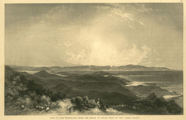
presenting the most desirable field for its operations. Port Nicholson was chosen for the first and principal settlement of the Company. The land forming the colony was disposed of in London in 1100 lots or sections, each of which consisted of one town acre and a hundred country acres, and sold at 101l. each.
Cook's Straits separate the northern from the middle island, and certainly possess a fine harbour in Port Nicholson, with the advantage of a central position as respects New Zealand generally. There is also an excellent harbour on the other side of the Straits in Queen Charlotte's Sound. The town of Wellington was founded at Port Nicholson twelve months in advance of Auckland, which is the capital. Port Nicholson is situated at the southern extremity of New Ulster, and forms the harbour of deposit and export for a line of coast extending from the east cape to Kawia on the west. It is not connected naturally with any very great extent of available country, the valleys at this part being very limited, which is unfortunate in the present state of the colony; and the defect is increased by the dense forests which cover the land in nearly every direction. The Valley of the Hutt comprises nearly the whole of the flat land in connexion with the port, where the alluvial soil is very deep and rich, but heavily timbered. The rivers which drain it are of little use; the principal one, the Heretaonga, being merely serviceable for large boats, and for a short distance only. The reaches are mostly a succession of rapids, and from the vast extent of mountains and hills in connexion with it, a very short duration of rain creates floods. This, however, is partially the case with all rivers in a state of nature, from the drift timber blocking up the water way, and from other causes.
The seat of Government was first fixed at the Bay of Islands, by Governor Hobson, in the commencement of the year 1840, the town being named Russel. This selection arose principally from the influence of the Missionaries, and the circumstance of one of the oldest trading settlements in the islands, or Kororarika, being established in this bay. Government House was removed to the estuary of the Hourake, or Frith of the Thames, before the expiration of the same year, and a new town founded, called Auckland. The first site for the capital was soon found to be very circumscribed, but the latter, situated on the south shore of the Waitemate in the district of the Thames, possesses many advantages. It is placed in an open country, in the centre of a great extent of available land, and with greater facilities for internal communication than is commonly to be met with in New Zealand. The land is rendered particularly valuable by the useful character of its rivers, a great desideratum in a new country. The river Kaipara and its branches afford water communication to the northward, and the Manukao and Wai-ka-to to the southward; the port is also considered a very good one, although, perhaps, not equal in its present state to Port Nicholson. Wharfs are necessary to make it complete, the landing at low water being both inconvenient and difficult. It is about fifteen miles from Kaipara Harbour, and five from Manukao, which is also a good one. The country around Auckland is open, and principally fern land, but it is said to be inferior to the fern districts of some other parts. The Waikato district is no great distance from Auckland, and the extensive plains of the Waipa on the west coast, also the valley of the Thames on the east, which, with the Piako, is said to be sufficient to answer all the purposes of colonization for some years to come. The beautiful climate of the northern parts of New Zealand has always been celebrated, being much warmer than the neighbourhood of Wellington. Geranium hedges are to be seen of good height, and all vegetation is most luxuriant.
The first Government land sale in the colony occurred in the month of April, 1841, when upwards of 21,000l. was realized for about thirty-four acres of land in the capital. The country land in connexion
[Image of page 3]
with it was put up in September of the same year at the upset price of 20l. for suburban, and 3l. for the rural land per acre, and 559 acres were sold for 5000l., being about 8l. per acre, although the best land was reserved. The purchasers consisted principally of speculators, and not of bona fide settlers, and they immediately cut up their allotments, as it is termed, and resold them in small pieces at exorbitant prices. There has been a trade in Kau-ri spars carried on in these parts for many years, the timber abounding in the northern districts. Copper is worked at the Great Barrier and Kawau Islands; the ore is generally found next the surface of the ground, and is very superior to the Cornish. Manganese is also found. Abundance of iron, of good quality, is distributed over the whole of New Zealand.
The number and warlike character of the native population at this part present the greatest drawback to its general advantages; but now that active measures are about to be taken by the Government, it is to be hoped that the necessary precautions will be used to impress these poor savages with a proper respect for our country and lawgivers. Besides the white people settled at Auckland and the Bay of Islands, there are some at Hokianga, a port and river to the northward; and parts of the west coast are also occupied by Englishmen. The whole white population of the northern settlements was estimated at 4000 at the termination of 1842. Auckland is about 300 miles from Tort Nicholson, by land, and 400 by sea; they are separated by a cape on either coast; therefore, until joined by a road, they may be truly said to form two distinct colonies. Perhaps the country about Auckland can be more readily subdued and settled at the present time; but Port Nicholson is the spot evidently pointed out by nature for the seat of government, which undoubtedly it must eventually become.
The settlement of New Plymouth, or Teranaki, is situated between Port Nicholson and Auckland, on the west coast. It is said to be the garden of New Zealand; the ground is principally covered with high fern, not too hilly, and of excellent quality. This district does not possess any harbour, the River Wai-te-ra affording shelter for small coasters only. The line of country, bounded by the sea from Teranaki as far as Wai-nui, to the southward, is nearly a plain, possessing a good soil with serviceable rivers. The ground is interspersed with forest, fern-land, and swamp; the hills are by no means objectionable. This fertile plain is bounded inland by the Tarerua and other mountain ranges, which run down the country and form the great back-bone of the island.
There is a small settlement at Wanganui, between New Plymouth and Port Nicholson, where the town of Petre is laid out. It is a beautiful district, with an agreeable climate, and altogether forms a delightful site for a small settlement. The hills bound the river on the east, and Mounts Egmont, at Teranaki, and Tongariro, another snowy mountain, terminate the landscape towards the northward. The river is only safe for small coasters, although a vessel of 300 tons has been taken in.
The Manawatu is another useful river, between Wanganui and Wellington, and flows through most beautiful and desirable land. This is the great rural district of the first settlement of the New Zealand Company, where the settlers proposed to have had their stock farms. Some of the most enterprising commenced preliminary operations, but, in consequence of the annoyances of the natives, were deterred from proceeding.
There are numerous whaling establishments along the coast; as at Table Cape, on the east coast, where there is a river, the Ahu-riri, connecting with a most valuable track of country, being both level, open, and with a good soil. A complete chain of lakes exists in the interior of the country, comprising Taupo, Rotu-rua, and several others, which run from the mountain Tongariro, and connect with the east coast. Volcanoes are found at this part, and hot springs and basins, which the natives find
[Image of page 4]
very handy for cooking purposes. Some of the springs constitute very agreeable baths; the natives use them as such, and frequently remain in the water all day.
New Munster, or the Middle Island, is not so well known as New Ulster; but it is believed to be of very similar character, a range of high mountains running longitudinally through the country. The vicinity of Banks' Peninsula has been long known as a favourite resort for whalers. The small settlement of Akaroa was founded by the French; it is undoubtedly an important position, and must form one of the most formidable rivals of Port Nicholson, the harbour being good and almost in close connexion with extensive plains of available land. There are also other good harbours close to it, as Port Cooper and Pigeon Bay, now called Port Ashley. The land generally to the southward along this coast is highly commended, and the harbour of Otago, which is said to afford every accommodation, is chosen for the site of the New Zealand Company's next settlement. There is also some good available country proposed for the rural sections, extending from Otago to the Molyneux, which is a good river, the valley possessing a soil of the finest description. The country also affords easy means of communication, both by land and water.
The second settlement of the New Zealand Company was founded in this island in the locality of Blind Bay, in the month of September, 1841, when the town of Nelson was laid out, although Governor Hobson wished the site of the settlement to have been at Mahurangi, which is situated to the northward. Nelson Haven is formed by a sort of natural breakwater, or bank, composed of large boulders; this bank is a few feet above high-water mark, and averages a quarter of a mile in width, lying parallel with the coast, and joining the land at one extremity. The town is laid out in a basin of 1000 acres, and enjoys a mild and serene climate, being inclosed by hills. The land belonging to this settlement is principally fern, and, like that around Auckland, it is considered by some judges to be of inferior quality, compared with other parts. The Waimea and Moutere districts are the best in this settlement. Coal and limestone are found close by in Massacre Bay.
The settlers at Nelson amounted to 2942, in October, 1843, including 147 of the higher and middling order.
Like their elder brothers of Port Nicholson, they are men of the greatest energy and spirit. It was the misfortune of the settlement to lose some of its best supporters in an attempt to perform the obligations of the Government, without the requisite means, on the 17th of June, 1843, when a collision occurred with the natives at the Wairau district, in Cloudy Bay, and Captains Arthur Wakefield and England, Messrs. Thompson, Richardson, Patchett, Cotterell, and Howard, were among the slain. The natives were headed by Te Rauperaha and Te Rangihaeata, chiefs belonging to the opposite side of the Straits. The loss of so many valuable lives should demonstrate to the Colonial, Office the utter impossibility of maintaining peace and security in these islands without the aid of regular troops, not indeed for the purpose of slaughter, but as a demonstrative force. There is no argument so powerful with ignorant savages as showing that you can crush them if they will fight.
The east coast of this island is very imperfectly known; but it is certain that there is very little available land, although possessed of several harbours. The coast of New Leinster, or the southern island, like many other parts, is only occupied by whalers, and being of such small extent will probably be left to those pioneers to civilization for some years to come.
[Image of page 5]
PLATE 1.
1. --SURVEYOR'S ENCAMPMENT. PORERUA BUSH.
A colony is commenced by the surveyors opening up the country for the settlers, and among the many new callings arising from the immigration, the surveyor's follower may be instanced, or survey-man, as he is commonly called. The land is first roughly explored, the hills and rivers traced, upon which narrow alleys, technically termed lines, are cut straight through the forest or bush, and in various directions for the purposes of the survey. Some of those lines form the skeletons of future roads, and extend a distance of many miles into the country, forming for a time the only available means of transit. A pocket compass is indispensable in travelling, and much circumspection is required by the young colonist not to lose the track, as it is very difficult to recover; the crossings of ravines and streams are the trying parts, but after a short time a man gets accustomed to it. A surveyor will distinguish a line in the forest when an ordinary person can see no track whatever. Some of our men became so expert, that they would frequently track a person through the bush by the broken twigs and foot marks. The consequence of losing the way is quite sufficient to keep the traveller constantly on the qui vive, and he accordingly learns to notice the most trifling irregularities of the country. The several varieties of trees and their sizes are observed, the height of banks, the direction of the flow of water in streams; the least appearance of smoke is soon scented, and he pushes forward eagerly to find the tent. Sometimes the traveller is doomed to be disappointed by one of the young surveyors having fired a large rata tree near the line, which will frequently continue burning for months after. The ears are next arrested by the barking of a dog, or the report of a gun, when he comes suddenly upon the surveyor's encampment. If all the men should be absent at their work, it is necessary to approach cautiously, for fear of any dogs which might appear before he is prepared, if he ventured too close to their master's property. The best way is to cooey loudly, in order to bring some of the party forward. A surveyor's party generally consists of himself and six men, five of whom are employed in cutting the lines, dragging the chain, and assisting in the surveying; the other one is called the cook, and is left in charge of the tents. It is his department to make up the fire and to cook the provisions, which consist of dampers, or bush bread, salt pork, tea, &c. He also shakes up fern for their beds, dries their wet clothes, cuts wood for the night, &c. The cook generally keeps a loaded gun handy, and any pigeon that flies near, or a duck at the brook, will rarely escape him. The encampment is always made at the side of a stream, for the convenience of water; a Wa-re is built open in the front, with the roof running down to the ground at the back part and the sides enclosed, the whole being formed of poles and covered with bark and fern leaves, cut from the trees on the spot: an immense fire is constantly kept up in front of it, with a long trunk placed before the hut, which prevents the men from rolling out in the night, or getting their legs into the fire; it also serves for a seat during their meals, and after they have done work. The surveyor either has another Wa-re built, also facing the fire, or he pitches a canvass tent. Surveying parties frequently live in this way for several successive months, provisions being conveyed to them every fortnight by others, called ration carriers. The men rise early in the morning, as they do not keep up late, and always appear in good spirits, but not noisy. They generally carry cards and draughts with them; and some of the maori's, who are excel-
[Image of page 6]
lent players at the latter game, frequently join the tent, when it happens to be near a native Pa. Bushmen do not drink anything stronger than tea, but they make up by constantly smoking tobacco; they can endure the want of food almost better than being without tobacco. The surveyor generally has a lamp in his tent at night, and amuses himself by reading the latest periodicals sent from England, or the last Wellington Gazette brought him by a visitor. This gipsying forms an agreeable contrast to common life. It was amusing to see, how pleased men living in this way were when any one found them out; the visitor was soon bewildered with questions, as "Any ship from England?" "Is there a mail?" "Have you any letters?" &c. &c. After which, they informed him of the latest news from the interior; that "the land in No. 10 Line continued good," "the further they cut into the swamp the better the land became," "there were no signs of the valley closing," &c. If there is no amusement in the bush, except such which nature affords, neither are there any laws to restrict the surveyors, but they are at liberty to hunt, shoot, and fish to their hearts' content; which, together with their duties of exploring and surveying the country, prevents their ever being dull. Some of them will make collections of ferns, mosses, subjects of natural history, or take sketches of anything remarkable that comes under their observation.
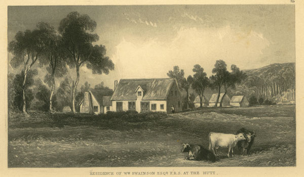
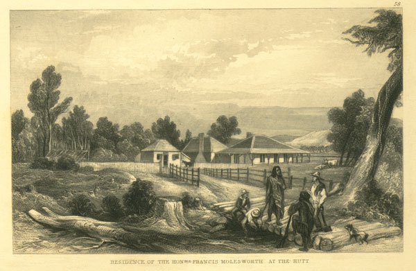
2. --MR. MOLESWORTH'S FARM AT THE HUTT.
The late Francis Molesworth, Esq., was one of the most enterprising of the settlers who emigrated under the auspices of the New Zealand Company. lie had brought a tolerable quantity of land into cultivation at his farm upon the Hutt, where he will be long remembered for his kindness, hospitality, and the manly bearing which he exhibited on all public occasions. He was among the first of the gentlemen of Wellington who volunteered to return in the Government brig to the scene of the Wairau massacre, on the occasion of the Victoria arriving at Port Nicholson for aid and assistance. His farm was in the best state of cultivation, and his garden well stocked with fruit trees and plants from England.
PLATE 2.
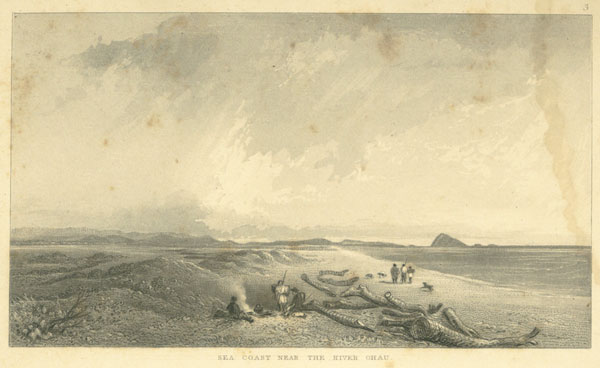
3. --SEA COAST NEAR THE RIVER OHAU.
Ohau lies on the west coast of New Ulster, in the route from Wellington to Manawatu and Wanganui; the river joins another, called the Wai-ka-wa, near the mouth, and the country upon it contains good soil, and is of very beautiful character. The View is taken looking south, and shows the hills in connexion with the Tarerua Range in the background, with the island of Kapiti. Sonic portions of the southern island are also in sight. A large quantity of timber is carried down the rivers to the sea, and, is thrown up along the shore by the action of the tides. This is made available for fuel by the natives, and collected in stacks, which thereupon become private property, and the rights of ownership are respected by other parties. The wood also comes very opportune for travellers, being one of the most essential articles required for the bivouac: journeying along this coast is very pleasant, although generally performed
[Inserted unpaginated illustrations]
Drawn by S. C. Brees
Late Principal Engineer & Surveyor to the New Zealand Company
Engraved by Henry Melville
[Image of page 7]
on foot, the sands affording better walking than the bush. Many have been the author's walks along the beach, and he can even now look back with pleasure to these trips; the greeting maori's at their Pa's on the rivers, the barking of the dogs, and the bawling of the women and children, with the constant inquiry for tobacco, "kahore te tobac" will long be remembered.
This part of the country has not yet been surveyed inland, although those settlers who have paid a visit to the interior have all been highly pleased with it. Mr. White, a young settler, attracted by the advantages of the locality, and at the solicitation of the chief, E Ahu, had a small stock farm there, and resided upon it for some time; he remained there at the period of the Wairau massacre (17th June, 1843), but afterwards withdrew to the vicinity of Wellington, as the natives became over troublesome.
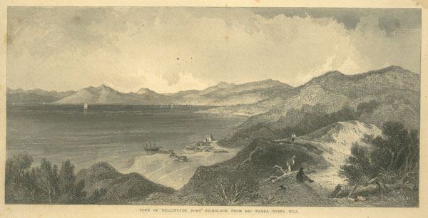
4. --TOWN OF WELLINGTON, PORT NICHOLSON, FROM KAI WARRA WARRA HILL
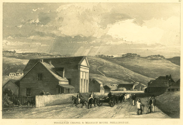
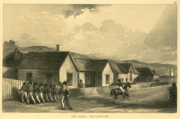
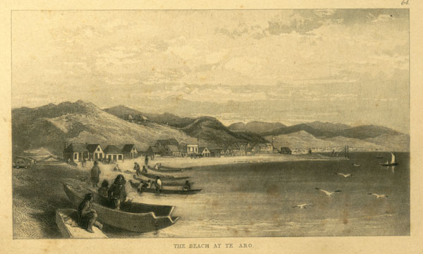
The town of Wellington may be called the capital of the New Zealand Company settlements. It was founded in the year 1839, and consists of 1100 acres, which were disposed of according to the regulations of the Company, independent of reserves for public purposes, town-hall, &c. Wellington is situated at the south-west corner of Wanganui Atera, or Port Nicholson, the water frontage enclosing Lambton Harbour. The character of the country around the port is mostly hilly and thickly timbered; there is, however, some extent of flat land at the valley of the Hutt, and a good portion in the town: some of the bays on the east side also furnish a few level patches. The population of the town of Wellington is at present principally confined to the two flats--viz., Pipitea or Thorndon Flat, and Te Aro; the former is not of much extent, but the latter is of tolerable size, and the greater part of the adjoining land is not very hilly. Thorndon Flat may be called the court end of the town, being the neighbourhood of Government House, the church, law courts, police court, New Zealand Company's survey office, &c.; while Te Aro accommodates the mercantile community, and comprises the Bank, Exchange, Custom-house, bonded stores, and the merchants' offices. The Gaol is also situated at this part, and the Catholic and the Wesleyan Chapels; the Scotch Kirk is placed on the beach, which is the grand line of connexion between them. The Independent Chapel is at Thorndon, and there are barracks for the military at both places. Te Aro Flat is situated at the head of the bay, where the vessels in port lie at anchor, which accounts for its adoption for the purposes of business. Thorndon possesses one advantage over Te Aro, in being the nearest to the country districts. The present road to Karori commences at a valley at the back of Thorndon, and the route to the Hutt and to Porerua from Te Aro lies directly across Thorndon Flat.
A very considerable quantity of the timber surrounding the town has disappeared, from the constant demands of the inhabitants, and the land has thus been brought into use by the least expensive process.
The view is taken from section No. 3, Kinapora district, on the old road to Porerua, and shows Lambton Harbour, with Mounts Victoria and Albert. Pipitea Flat, with the houses, may be observed, and Te Aro at the head of the bay. The Kai-warra-warra stream is shown below, with Mr. Matthieson's improved slip and other buildings. The Clydeside, a vessel of 230 tons, and the Indemnity of 400 tons, were hauled up and repaired on this slip.
[Image of page 8]
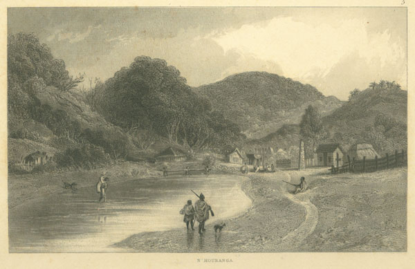
5. --NGA HOURANGA.
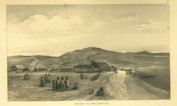
The Nga Houranga is situated on section No. 8 of the Harbour District of Port Nicholson. The stream, which is not very deep, is crossed by the Hutt road. There is a native Pa at the spot, where the famous chief Warepori resided; he was the great fighting general of his tribe, and one of the most celebrated among the Maori's inhabiting Port Nicholson at the period of arrival of the Company's first settlers. There is a story related of his having been capsized with his canoe near Somes' island in a heavy sea, when he swam to the Nga Houranga, a distance of upwards of two miles. He was afflicted with a tumour in the head latterly, which terminated fatally. His remains were interred at Pitone, and the natives of his Pa erected a monument to his memory at Nga Houranga, which is represented in the View. A large canoe having been sawed into three pieces transversely, the middle part was set up on six posts, and the two extremities placed together and raised up on their ends, a bunch of feathers being placed on the top. A small effigy of Warepori was also placed by the side. The monument was then painted with red colour, ornamented with scroll work, and "tabued," or rendered sacred.
PLATE 3.
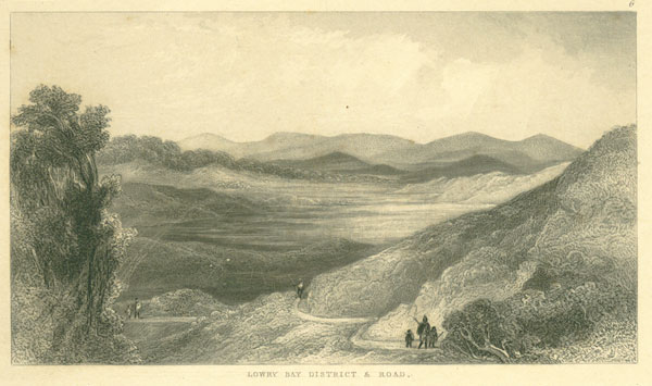
6. --LOWRY BAY DISTRICT AND ROAD.
This is a district adjoining Port Nicholson, consisting principally of swamp and fern. The swamps of New Zealand are mostly attributable to the falling of trees across the rivers and water-courses, the accumulation of vegetable matter, and other natural causes, and will not present great difficulties in draining. There are two mountain streams connected with this district, the Wai-nui-o-mate and the Oronga-ronga, which join the sea in Fitzroy Bay. The valley of the former contains the largest extent of alluvial soil upon a flat bottom of any district in this part, except the Hutt, which it may be ranked after. A road will be carried over this way to the Waira-rapa some day, as a cross line to Palliser Bay.
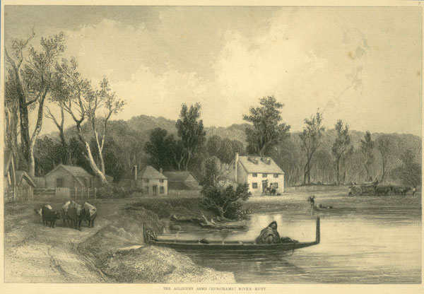
7. --THE AGLIONBY ARMS (BURCHAM'S) RIVER HUTT.
The nucleus of a village has been formed by Mr. Daniel Riddiford, on his section, No. 17, in the Lower Hutt, which he has named Aglionby, and Mr. Burcham has built an hotel there, for the accommodation of visitors to this fine district. Mr. Riddiford's stock-yard is shown in the View on the left of it; the scene has a quiet agricultural appearance. More than half the land in cultivation, by the settlers of Port Nicholson, is in the valley of the Hutt, and the white population residing there amounted to 644 at the beginning of the year 1845.
[Inserted unpaginated illustrations]
Drawn by S. C. Brees
Late Principal Engineer & Surveyor to the New Zealand Company
Engraved by Henry Melville
Drawn by S. C. Brees
Late Principal Engineer & Surveyor to the New Zealand Company
Engraved by Henry Melville
[Image of page 9]
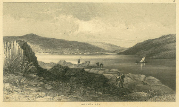
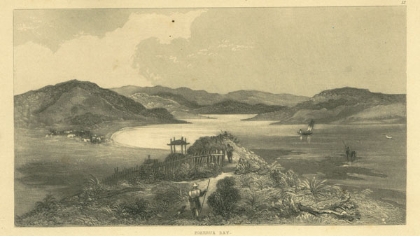
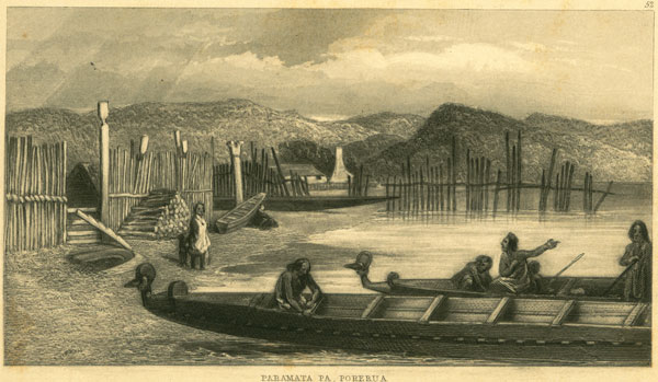
8. --PORERUA BAY.
Porerua is about twelve miles north of Port Nicholson, in the route to Manawatu and Wanganui. The harbour is entered from the bay by a somewhat narrow channel, and the depth of water is only sufficient for coasters. Mr. Thoms has a whaling station and a house of accommodation here for travellers. The land around the harbour is very good, but thickly wooded. The harbour, like Port Nicholson, teems with fish. The hapuka and the moki are the most esteemed, but much dissatisfaction sometimes ensues, from our fishermen taking them at the wrong season.
PLATE 4.
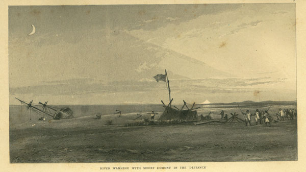
9. --RIVER WANGAEHU, WITH MOUNT EGMONT IN THE DISTANCE.
The river Wangaehu is to the south of Wanganui. The wreck shown in the View, occurred while the author was travelling the beach, the master having mistaken this for the latter river. There are always plenty of natives about the coast, ready to take advantage of any accident, and who consider themselves justified in plundering all wrecks, because it is according to their custom!
Native pa's are generally formed at the mouths of rivers, for the convenience of fishing, &c, which are left when the season is over, or the potatoes in some remote garden are ripe; the canoes are hauled up high and dry, and covered over with boughs to prevent the sun from injuring them, and their treasures buried near the pa, where they remain until the return of their owners. The natives belonging to the pa sometimes leave some potatoes secreted in the ground for food, in case of their paying a flying visit to the coast, which travellers, including ourselves, have often tried to find, when short of rations, ("out of kai") by probing the ground about with our ramrods.
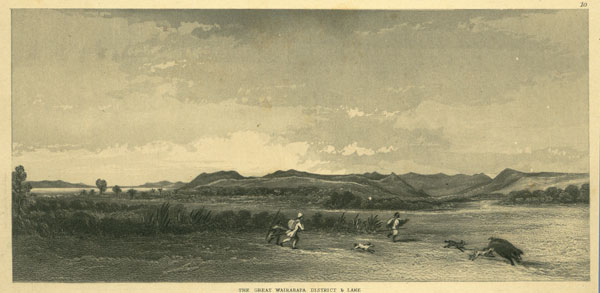
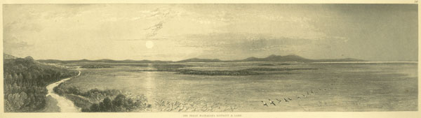
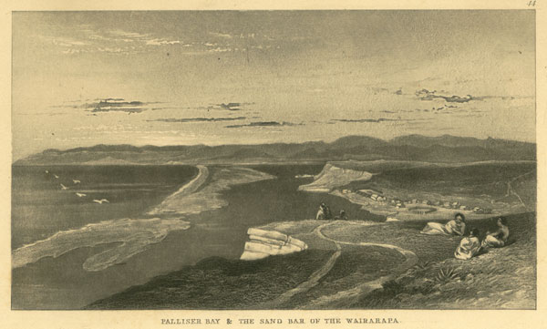
10. --THE GREAT WAIRARAPA DISTRICT AND LAKE.
This is unquestionably the most important district to the settlers of Port Nicholson. It extends by a level plain far into the interior of the country, within two lofty ranges of hills, forming the heads of Palliser Bay. As there is no harbour in immediate connexion with this fine district, it should at once be connected with Port Nicholson by a good road. The author became impressed with the importance of this measure, while engaged in his official duties in the colony, and he succeeded in laying out a very direct road to it up the valley of the Hutt, and across the Paku-ra-tihi; and about two-thirds of the distance was completed at the period of the New Zealand Company suspending operations, (19th August, 1844,) as shown by the following table:--
[Image of page 10]
Survey Office, Wellington,
August 19th, 1844.
Hutt Line of Communication with the Wairarapa District.
TABLE of DISTANCES from WELLINGTON, (the road is made as far as the Mungaroa Upper Hutt.)
Miles. Chns. Links.
Pipitea Point to Kai Warra Stream (centre)..................1 14 40
Kai Warra Stream to Ngauranga Stream (centre)................1 45 0
Ngauranga Stream to Koro Koro Stream (centre)................3 00 75
Koro Koro Stream to south side of Hutt Bridge... ..............2 25 08
South side of Hutt Bridge to Mr. Boulcott's (northern extremity of fence)........1 56 32
Mr. Boulcott's to South side of Wai-Wetu Bridge................1 51 62
South Side of Wai Wetu Bridge to centre of Bridge on Section No. 61, Lower Hutt.....1 10 95
Centre of Bridge on Section No. 61, Lower Hutt, to summit of First Gorge........1 4 34
Summit of First Gorge to Stokes' Valley Stream Bridge (south side)..........0 63 45
Stokes' Valley Stream Bridge to summit of Second Gorge .............0 56 65
Summit of Second Gorge to foot of Second Gorge................ 0 47 05
Foot of Second Gorge to Crossing of No. 1 Line.................1 12 69
Crossing of No. 1 Line to Crossing of No. 2 Line and Silver Stream..........1 27 30
Crossing of No. 2 Line and Silver Stream to Crossing of No. 3 Line.......... 1 15 60
Crossing of No. 3 Line to the Angle (at the end of the long line)...........1 14 25
The Angle to Entrance to Old Maori Garden..................0 68 98
Entrance to Old Maori Garden to centre of X. M. R. Bridge and Side Cutting. Section 170, Upper Hutt.............................1 12 90
X. M. R. Bridge and Side Cutting to South side of Mungaroa............1 60 05
Total length of Road completed................24 27 38
The distances from thence (road surveyed but not made) to end of Survey Lines......2 47 0
End of Survey Lines to Pakuratahi River...................2 60 0
Pakuratahi River to summit of Rimutaka...................2 52 0
From thence to Wairarapa, not surveyed.................say 2 50 62
Total distance from Wellington to Wairarapa...........35 0 0
The district is admirably adapted for grazing, with plenty of land for arable purposes. Mr. Duke was the first who settled there. He took forty head of cattle round to the district, by the coast, in the month of April, 1844, as a squatter. Mr. Bidwell soon followed him with sheep and cattle, also Mr. Vavasour, and others.
There are abundance of wild pigs in the Wairarapa, and which are very useful as food for the squatters and visitors. The pigs are hunted by dogs, and the chase is very exciting: a boar will generally afford good sport; and one has been known to keep half a dozen strong dogs at bay, and to kill two of them before he has been overcome. Upon the dogs coming up with a pig, they generally seize him by one of the ears or his jowl, and they never leave go, although frequently dragged along by the pig for some distance, when the men either despatch him while thus engaged or tie his legs. The dogs are a sort of bull terrier, and very strong and courageous. The pigs fatten well upon fern root and the raupo in the swamps. The View exhibits the range of hills towards Port Nicholson and the Otiwera Valley.
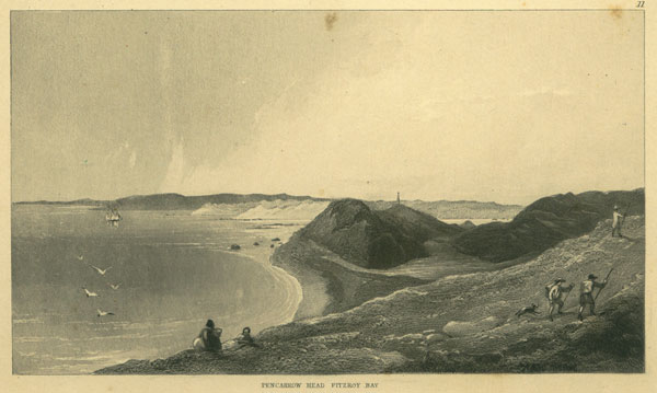
11. --PENCARROW HEAD, FITZROY BAY.
The weather in Cook's Straits is showery and gusty, and sometimes violent. The View shows the Straits and the entrance to Port Nicholson. There is a depth of water equal to eleven or twelve fathoms
[Inserted unpaginated illustrations]
Drawn by S. C. Brees
Late Principal Engineer & Surveyor to the New Zealand Company
Engraved by Henry Melville
[Image of page 11]
over it at low water. A light-house is indispensable to insure safety in making the harbour at night, but it is at present simply furnished with two beacons at the heads. The southern is erected on Pencarrow Head, and consists of a round timber tower, which may be observed in the View. The other is formed of three tiers of timber butts, viz. --four next the ground, three above, and one on the top, which are filled with stones. This landmark is placed on the highest peak, between the mouth of the harbour and Lyall's Bay.
The Straits are about thirty miles in width, from the southern entrance of Queen Charlotte's Sound, in the middle island, to the headlands of Port Nicholson. The Sound possesses several good harbours, the whole completely land-locked. It is strange that Captain Cook, although so well acquainted with the Sound, which he highly esteemed, knew so little of Port Nicholson. He once laid at anchor at the entrance, when the natives, upon each side, came on board his vessel. He describes Chaffer's Passage and Barrett's Reef very accurately, although he did not proceed any further in.
PLATE 5.
12. -- PORERUA BAY.
The district of Porerua has been noticed in a former part of the work. The present View is taken from the native path, passing through the bush from Porerua to Pukeroa. These paths generally run along the ridges and spurs of the hills. A native potatoe garden is shown in the View, inclosed in, with the little covered stages for the preservation of the seed potatoes. The valley shown on the left is called Taupo, and is the spot where Rangihaeata intrenched himself after the Wairau massacre.
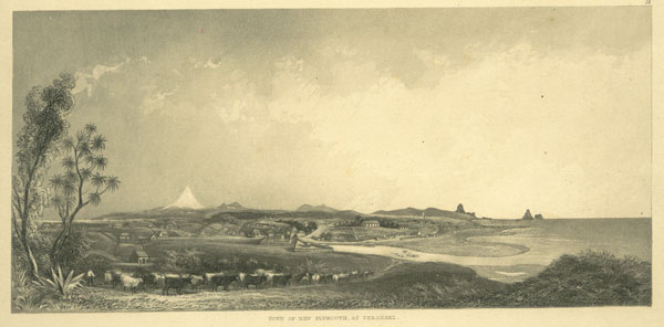
13. --VIEW OF NEW PLYMOUTH, TERANAKI.
The settlement of New Plymouth is most advantageously situated as respects the character of the country, but without any accommodation for shipping. Heavy moorings from England were laid down by the New Zealand Company, calculated to afford a hold to vessels of large burthen, but which have been carried away. Mount Egmont forms a prominent object in the View, and the Sugar Loaf Islands on the right of it. The river Waitera, which has not more than live feet of water over the bar at low water, is also shown. This must soon become a great corn-growing district; 880 acres of land were in cultivation in the year 1845, the greater part of which was in wheat.
Teranaki is the former home of the Nga-ti-a-wa tribe, at present occupying Port Nicholson, including E Puni and the late Warepori, and from whence they were driven some few years ago, before the occupation of Port Nicholson by white people. Mr. Richard Barrett, a whaler, was long associated with these natives, and shared in their reverses, but he has since returned to his old quarters at Teranaki, and his former business of whaling.
[Image of page 12]
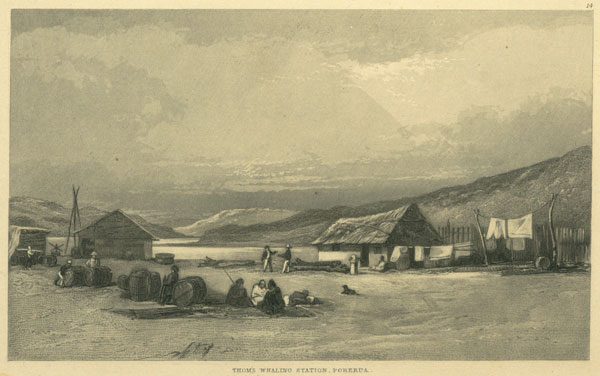
14. --THOMS' WHALING STATION, PORERUA.
Mr. Thoms has long had a whaling station at this port; he also keeps a house of entertainment for travellers on the same spot, and ferries them over the harbour. The whalers' house and sheds are shown in the View. The sea lies in a direction towards the right, and the depth of water near the shears is about twelve fathoms.
The whaling from shore parties was commenced about the year 1827, by the sealers frequenting the southern parts of New Zealand, who were induced, from the scarcity of seals, to try their hand with the whale. The vicinity of Cook's Straits was the scene of their earliest efforts. Kapiti and Cloudy Bay had been long resorted to by whaling ships, and some of the crews generally managed to run away and join the shore parties. The whalers therefore have been associated with lawless habits, bold and hardy from the commencement. A station usually numbers several boats. The whale boat is long and sharp at both ends, and generally built for five rowers, although six, seven, and even eight-oared boats are used at the present time. The boats are not steered by a rudder, but by a long oar, which is in the hands of the headsman, and affords him great power over it. The rower at the head also acts as harpooner, and after making fast to a whale, the oars are peaked or balanced out of the water on each side, and the boat is drawn through the sea in the track of the whale at a fearful velocity. After going along in this way for some time, the cord being taken in and paid out again, as found necessary by the headsman, perhaps another boat fixes on the fish; water being poured over the rope where it chafes against the boat, to keep it cool. Upon the whale becoming tired it is killed by the headsman, who goes to the head of the boat and takes the place of the harpooner, who then becomes the boat-steerer. The finishing strokes are generally given with the lance or spade. The whale is afterwards anchored for the night, or towed ashore, according to circumstances.
The chase of the whale, like all sports in which danger is associated, is very exciting, and much judgment and powers of endurance are displayed by the men. Although there are no written laws among the whalers, yet they have a regular code in force, which has been handed down by custom and tradition. The first boat which makes fast to a whale is allowed to be entitled to her. The season commences in May and continues until the beginning of October.
The men are generally employed "on the lay," which is a system of sharing the proceeds arising from the sale of the oil and bone among them, the headsman and steersman having extra shares. The owner of the station fits it out, and receives a certain number of shares; he supplies the men with whatever they require, which is paid for at the end of the season, generally at very exorbitant prices. The catch of fish is very uncertain; but when the season is good the amount of an oarsman's wages amounts to about 80l. or 40l., after spending which, unless such is impossible, they retire to the vicinity of the native pa's with their wives. Although the whalers are generally a reckless class, still there is much hospitality and good feeling exhibited by them, partaking in some degree of the character of the British sailor. They take wives for a time from among the native women, who have a strong partiality for the white man. The natives build their houses and frequently take a part in the whaling operations, and when short of food they will not scruple to eat the flesh of the whale.
The blubber or fat is removed from the whale and cut into pieces of about two feet in each direction.
[Inserted unpaginated illustrations]
Drawn by S. C. Brees
Late Principal Engineer & Surveyor to the New Zealand Company
Engraved by Henry Melville
[Image of page 13]
These are melted into oil over a fire, in a large vessel, called a try-pot, about six feet diameter, and made in the shape of a common go-ashore, with legs. The oil is conveyed into coolers, and afterwards to large casks, ready for shipment.
Whales sometimes yield twelve or thirteen tons of oil; but nine is considered very well. The practice of whaling from shore parties is undoubtedly very injurious to the fisheries--most of the fish will be slaughtered in the course of time, the catch of oil being already much diminished. The oil and whalebone caught in the neighbourhood of Port Nicholson, in the year 1844, was worth about 50,000l. in the London market.
Plate 6.
15. -- WAIRARAPA.
This View is taken from the western side of the valley, looking towards the sea, and represents the spot where the author bivouacked on the 8th of February, 1843, when on an exploring expedition, in company with Mr. Edward Chetham and Mr. Parton; the native chief A Kuri, and a party of white men and natives. Wherever the ground has been worked there is always wild cabbage, parsley, and turnips, to be seen. A vigorous shrub is also found, called tutu by the natives, which often proves fatal to the cattle, at certain periods of the year, when eaten in too great quantities, having the same effects upon them as clover in our country. There are berries growing in clusters upon it, the seeds of which are also highly pernicious, but the juice is very sweet and pleasant; the natives, however, always caution the white men not to drink too much of it; and say, it is "all the same as te wai-pe-ra" or spirits.
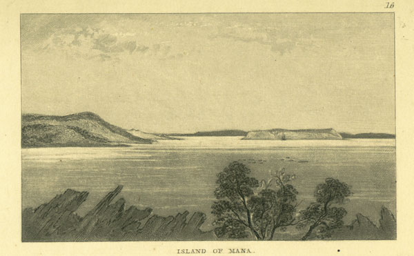
16-- MANA.
This small island lies opposite the entrance to Porerua harbour, and is the chief residence of Rangihaeata. It is named Table Island in the maps.
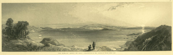
17. --PORT NICHOLSON--SHOWING THE HEADS, AND WELLINGTON IN THE DISTANCE, FROM LOWRY BAY.
The View is taken from the north-east corner of the harbour, near Mr. Jackson's house; the entrance is shown on the left. Wellington is situated to the left of the larger island, which is named after the late Joseph Somes, Esq. The state of the colony, in May, 1845, when the author left Wellington, may be partly gathered from official returns made at the commencement of that year. The amount of land in cultivation in the neighbourhood of the Port Nicholson district appears to have been 1070 acres, of which 546 were in wheat, besides that at Wanganui, as will be seen by the following Table:--
[Image of page 14]
| DISTRICTS.
|
No. of
Sections in
Cultivation.
|
No. of
Cultivators.
|
Acres
of Wheat.
|
Acres
of Barley.
|
Acres of
Green Crops.
|
Acres
of Grasses.
|
| Kai Warra Warra
|
4
|
9
|
17 1/4
|
6 1/2
|
3 1/2
|
1 1/2
|
| Porirua Road
|
12
|
41
|
61 5/12
|
15
|
22 5/8
|
7 3/4
|
| Ohariu Road
|
1
|
3
|
3
|
1
|
1.
|
...
|
| Lower Hutt
|
29
|
72
|
353
|
79 1/2
|
101 3/4
|
42 3/4
|
| Harbour District
|
9
|
33
|
34 1/2
|
10
|
21 3/4
|
23
|
| Lowry Bay
|
2
|
2
|
3 1/4
|
1 1/4
|
3/4
|
...
|
| Wai-nui-o-mata
|
2
|
2
|
1 1/4
|
...
|
1/2
2
|
...
|
| Karori District
|
9
|
55
|
33 5/8
|
11 1/2
|
44 1/2
|
6
|
| Ohiro
|
4
|
13
|
19 1/2
|
25 3/4
|
10 1/2
|
1/2
|
| Park Vale
|
1
|
10
|
8
|
4
|
2
|
...
|
| Evans' Bay, &c. &c.
|
4
|
4
|
...
|
...
|
1 3/4
|
24
|
| Manawatu and
Horowenua
|
8
|
7
|
12 1/2
|
21 1/2
|
1
|
...
|
| Wanganui
|
14
|
16
|
63 1/4
|
16 3/4
|
7
|
16 1/2
|
| TOTAL
|
97
|
267
|
610 1/2
|
192 3/4
|
248 1/4
|
122
|
The amount of population is stated at 4047, of which 1769 were under fourteen years of age, exclusive of the settlers at Manawatu, Wanganui, and along the coast. The live stock in the settlement were as follows:--Horses, 200; cattle, 1900; sheep, 5000; mules, 40; asses, 10; and 1000 pigs were taken to Wellington, coastways, by the natives, and upwards of double that number overland, in the year 1844, which were purchased by the colonists and consumed for food.
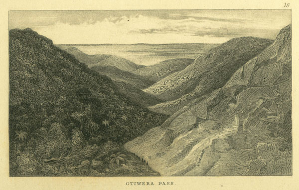
18. --OTIWERA PASS.
This represents a low part of the Remutaka mountains and the valley of the Otiwera, with the plains of the Wairarapa in the distance. The author passed down this ravine on the 7th and 8th February, 1843, accompanied by A Kuri and party, while exploring for the road from Port Nicholson.
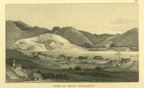
19. --TOWN OF PETRE, WANGANUI.
This little settlement has always been a favourite with its residents and visitors. It was laid out for the holders of the secondary seriers of land orders of the New Zealand Company. The View is taken du the north side of the river, and represents the church and houses of the settlers. The number of acres in cultivation, at Wanganui in the year 1844, amounted to 103 1/2, of which 63 1/4 acres were in wheat.
[Inserted unpaginated illustrations]
Drawn by S. C. Brees
Late Principal Engineer & Surveyor to the New Zealand Company
Engraved by Henry Melville
[Image of page 15]
PLATE 7.
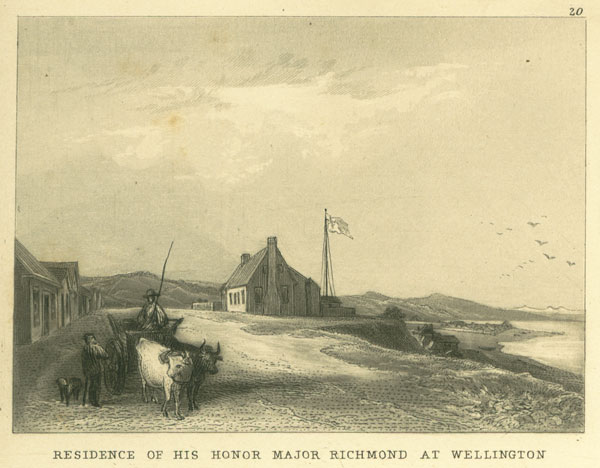
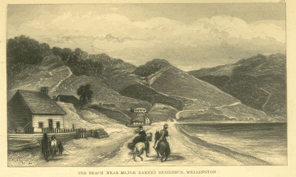
20. --RESIDENCE OF HIS HONOUR MAJOR RICHMOND AT WELLINGTON.
This scene lies at Thorndon Flat, Wellington. Major Richmond's House is situated on a terrace, and the store, on the opposite side of the street, belongs to Major Hornbrook. Pipitea Point and Pa are shown below, with Wade's Town and the Hutt in the distance.
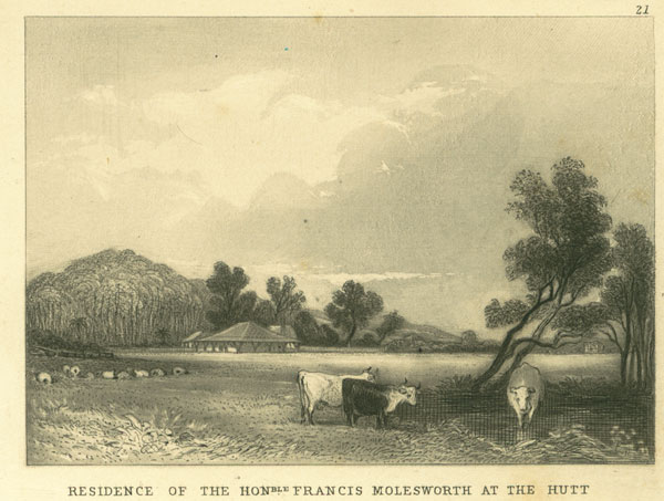
21. --RESIDENCE OF THE HON. FRANCIS MOLESWORTH AT THE HUTT.
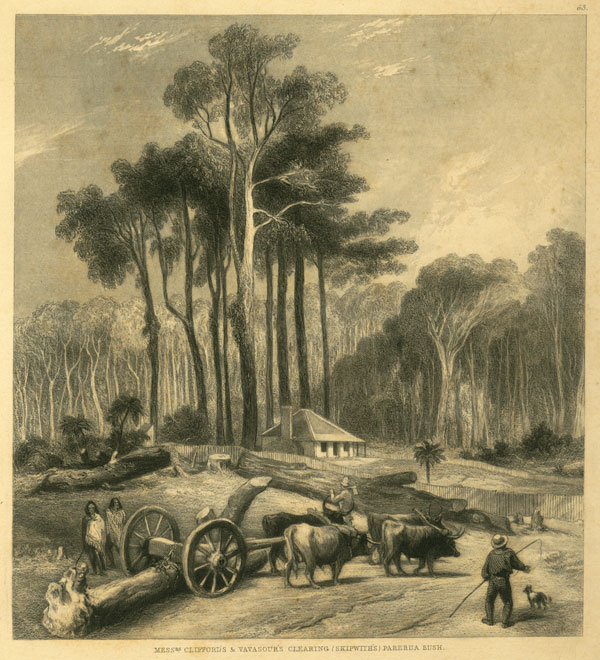
This represents some of Mr. Molesworth's clearing and his house. The whole of the forest trees and bush have been removed from the vicinity of the dwelling, as precautions against fire. Any dry branches lying near the settler's house often endangers the whole during the summer months, when extensive fires are made in the new clearings throughout the country of all the prostrate timber. The bush which has been previously cut down for the purpose of clearing the land is generally fired in January or February, and it requires the greatest care to prevent damage to the houses and crops if the wind sets in unfavourable.
High fern invariably comes up wherever the forest has been cleared any time, which is the next thing to be eradicated. The roots of the fern seem to furnish a highly farinaceous substance, which formerly constituted the principal support of the natives. The wild pigs are very fond of and fatten well upon it.
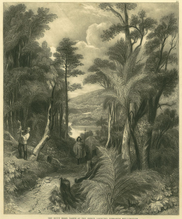
22. --THE HUTT ROAD, TAKEN AT THE GORGE, LOOKING TOWARDS WELLINGTON.
The road from Wellington to Wairarapa passes up the valley of the Lower and Upper Hutt, which are separated by a rocky gorge, where the road is curried over the hills. The plate represents the View looking towards Wellington from these hills.
Nearly all the trees in the New Zealand forest are evergreens, and present a very diversified character, according to the nature of the soil. On rich alluvial soils, trees of the largest size flourish, as the Rata, Pukatea, Kaikatea, Mai, Totara, Rimu, Tawa, and numerous other kinds, which are accompanied by dense underbush and supplejack, thickly matted in every direction, with numerous creepers and parasitical plants, and the ground is covered with dwarf ferns in great variety. As the soil becomes of less depth, and clay appears, the Rimu pine becomes more prominent, and on high hills and terraces of cold clay the Towai only is seen; the forest becomes parklike and quite open, like those of Australia, with very little underbush and no supplejacks: the ferns covering the ground resemble mosses, and are soft as velvet to the feet. Some of the timber is admirably adapted for ship building; no less than eight coasting vessels were built at Wellington of it in the year 1844, and equal to a tonnage of 144 tons, independent of whale boats.
The Totaro is the most valuable tree in the southern parts, to which it is confined: the wood resembles
[Image of page 16]
cedar in appearance, and is prized by the natives for canoes. It is extremely durable, and also very beautiful and valuable for ornamental purposes. The Kaikatea is another pine, with a very clean white wood and close allied to the Kauri. The latter tree has long been held in the highest estimation for spars, &c, being very light in weight; it prevails only in the northern parts of the Northern Island, and is sometimes found with a trunk equal to 40 or 50 feet in circumference, and 100 to 120 feet high without a branch, the total height of the tree being from 200 to 230 feet. Those usually cut for shipment are about 10 feet in circumference; in some experiments lately made in this country this wood resisted decay better than all the other specimens tried. The Rata is one of the largest trees of the forest, and the wood is very hard; the trunk is of a twisted and crooked shape, with numerous stems growing up in sort of clusters. The tree is not unlike the oak in general appearance, but considerably larger, and with very small leaves, and it is covered all over with bright myrtle blossom at the time of flowering. The young tree is very seldom seen standing alone, but always found entwined round the trunk of other large trees of the forest, which form supports for it, and the rata at last occupies the site of the tree on which it grew, no trace being left of the latter; the young shoots encircle the doomed tree in every direction, striking both upwards and downwards into the earth. The author has seen the trunk of a Pukatea tree with several small rata stems from 4 to 6 inches diameter inside of it, and at every part where the trunk was severed with a cross cut saw, the exact same cross section was exhibited. He has also measured a rata growing on the top of a high saddle-backed hill, skirting the river Hutt, 56 feet in circumference, perfectly truncated and of proportionate height; the forest where this tree grew was of the ordinary character, but the rata towered so high above all, that on viewing it afterwards from the hill on the opposite side of the river, it appeared almost solitary; trees of this character, however, are by no means uncommon. The Mira is a heavy wood and well adapted for the same purposes as lignum vitae, but it may be procured in almost any sizes; some of it is also very beautiful. The Hinau is a tree of rather contorted appearance; the wood is very ornamental, and the bark celebrated for dyeing purposes; the natives obtain their black dye from it, with which they ornament their mats. The bark is stripped off the tree and soaked in water, and the flax to be dyed placed in it, which is afterwards taken out and merely rubbed in the bottom of some muddy stream containing iron in a state of suspension, which is a common character in many of the streams in New Zealand. The bark of the Tanakaka affords the natives a red dye for their Kai-ta-ka mats. The common red ochre with which they paint their persons and houses, &c, is procured by digging in the beds of streams. The bark of the Hinau and Towai, or black birch, are also much valued for tanning purposes; the wood of the latter makes excellent staves for ton butts. The Tawa is a valuable wood for the bivouac, as it burns well in a green state; the fruit resembles a small plum in appearance, but is not so palatable. The Pitau, or arborescent fern, abounds everywhere; it is frequently to be seen upwards of 30 feet high, and, together with the Nikau, resembles the palm in appearance. Many of the fruits and berries are said to contain a valuable oil, as Titoki, which has been sent to England, and tried for the finer parts of machinery. The fruit somewhat resembles a raspberry in taste and appearance, with a black kernel in the middle, from which the oil is extracted. This tree is tall, but rather slight, and the wood when cut is white, like the ash, and being hard is preferred for axe handles by the bushmen.
[Inserted unpaginated illustration]
Drawn by S. C. Brees
Late Principal Engineer & Surveyor to the New Zealand Company
Engraved by Henry Melville
[Image of page 17]
PLATE 8.
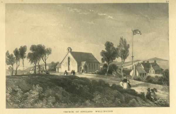
23. -- CHURCH OF ENGLAND, WELLINGTON.
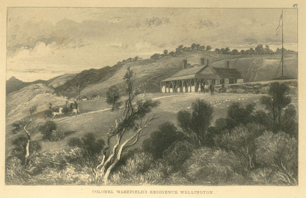
Dr. Selwyn, the Bishop of New Zealand, landed at Wellington on the 12th of August, 1842, and introduced the Rev. Robert Cole, M. A., to the settlers as their future Minister, who has succeeded in securing the good will and respect of all classes of the community. After due preparation, a church was built, something after the style of the Christian model at home, and of the early English era, and which is represented in the View. The back of Colonel Wakefield's house is seen on the right of the church, with the harbour.
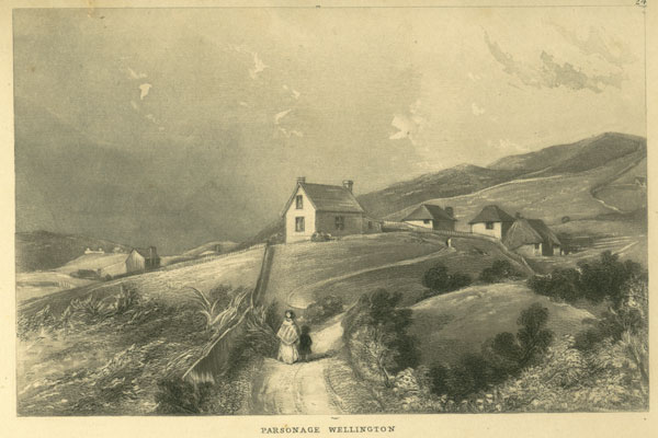
24. -- PARSONAGE, WELLINGTON.
The situation of the Parsonage, where the Rev. Robert Cole resides, is rather exposed, but commands very fine views. The Bishop of New Zealand lives at Wai-te-mate, a village to the north of Auckland, in which locality he has established a college.
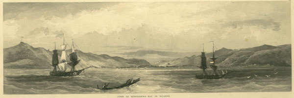
25. --TOWN OF KARORARIKA. --BAY OF ISLANDS.
The Bay of Islands is one of the finest harbours in New Zealand, and was formerly a great resort for whalers. Karorarika has long been the chief station of the Church Missionary Society, some of their agents having settled there about thirty years ago. There have been two other towns more recently founded in the Bay--viz., Victoria, where Mr. Busby, the British resident lived, and Russel, the first capital of Governor Hobson.
This spot has become too well known at home from having been the scene of one of the late outrages of the natives. The town of Karorarika was attacked by the natives under Heki and Kawiti, in three different quarters, early in the morning of the 11th March, 1845. One division was led by Honi Heki, which was directed towards the flag staff, shown on the hill to the left in the View, and he succeeded in taking the block-house, erected for the purpose of protecting it, and subsequently in cutting down the flag-staff. The other parties were repulsed with considerable loss by Captain Robertson, of H. M. sloop of war, "Hazard," with a mere handful of sailors and marines. The settlers were collected together within a stockade on the beach, when, from the neglect of proper precautions, the powder magazine blew up, which necessitated them to go on board the vessels in the harbour, and take refuge at Auckland. The hostile natives being then left in possession of the town, ransacked, and finished by setting it on fire. The property destroyed has been estimated at 60,000l.
[Image of page 18]
PLATE 9.
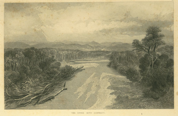
26. -- THE UPPER HUTT DISTRICT.
This View is taken from Section 180, of the Upper Hutt, which is situated on a high terrace, looking down on the river. The country is heavily timbered, as may be seen by the View, and some of the old native clearings and gardens appear on the sides of the hills opposite.
Although the forests are not thickly inhabited by the feathered tribes, there are many birds to be met with; as the wild pigeon, which is extremely large and very common; the parrot or ka-ka, and the tui or mocking bird, which is about the size of the English blackbird, and of the same colour, but with two bunches of white feathers under the neck; his notes are few in number, but very melodious, resembling the tinkling of small bells, which harmonize together as they are delivered. They are all very good eating. Birds of prey, as the falcon, hawk, owl, and numerous others, are found. Small teal and pu-tangi, or the Paradise duck, are generally met with at the mouths of rivers. The drake is nearly black, and the duck, light brown, with white head and neck. The bush frequently resounds at midday during the summer months with the buzzing of a large beetle, which lives in the trunks of fallen trees.
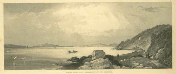
27. --PITONE ROAD, WITH WELLINGTON IN THE DISTANCE.
Pitone is situated on the beach of Port Nicholson, skirting the district of the Hutt. The road forms a great accommodation to the settlers, as there is a good amount of traffic between Wellington and the Hutt. The waggons are generally drawn by four bullocks, two abreast. Bullock driving, or the carrier trade, is a thriving one in a colony, comprising the removal of agricultural produce, the drawing of logs, scantling boards and shingles, from the bush, and the removal of goods in the town. As a trade in timber has been carried on for many years past in New Zealand, a number of men have always been engaged in the forests, cutting down the trees and sawing wood, and they are almost a distinct class, like the whalers. There are a large number of sawyers at the Hutt and the other rural districts, sawing up timber. Another class carry on a business in splitting trees, after they are felled, into small thin boards, termed shingles, which resemble slates in size, and are employed for roofing. These men earn a very excellent living, and seldom or never offered their services at the Survey Office for employment. Much dexterity is displayed in cutting down the trees. Some of the axemen employed on the survey, singly, could fell a tree of two or three feet diameter in fifteen or twenty minutes. They never strike in vain, but make every blow tell. Two men generally work together, one a right-handed, and the other, if possible, a left-handed man. Upon determining which side the tree shall fall, they chip out a large wedged-shaped recess in that direction with their axes, then set to work on the opposite side, and after a short time, the trunk, being weakened by the large notch made at the back, soon topples over, overthrowing numerous other trees, and making the forest ring again.
[Inserted unpaginated illustrations]
Drawn by S. C. Brees
Late Principal Engineer & Surveyor to the New Zealand Company
Engraved by Henry Melville
Drawn by S. C. Brees
Late Principal Engineer & Surveyor to the New Zealand Company
Engraved by Henry Melville
[Image of page 19]
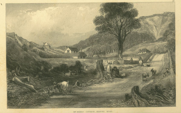
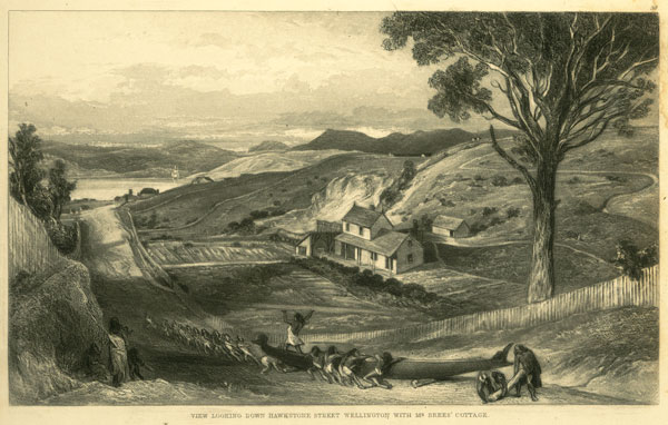
28. --MR. BREES' COTTAGE, KARORI ROAD.
This valley was once covered with thick forest, of which only one tree is now left, a kaikatea or white pine, which did not present sufficient attractions to the sawyers in the early stage of the colony. Having escaped the general slaughter, it is now preserved for the sake of ornament. The hills shown in the background are called the Tinakore Range, and form part of the Town Belt. The situation of the house is very sheltered and healthy, with a very fertile soil; live stock, as fowls, ducks, turkeys, goats, &c. flourished exceedingly, and the increase required constantly killing off in order to keep them within reasonable limits. The View shows the commencement of the Karori Road at Hawkstone Street. The house on the hill to the left was built by Mr. Joah Wakefield, and that at the top of the road was once the residence of Mr. Brandon.
Karori is the only rural district in immediate connexion with Thorndon; the land is not generally very hilly, but it is thickly timbered. The following shows the distance from Wellington.
Survey Office, Wellington,
August 19th, 1844.
Karori Road.
TABLE OF DISTANCES FROM WELLINGTON TO BRIDGE OVER KARORI STREAM.
Miles. Chns. Links.
Pipitea Point to corner of Mr. St. Hill's fence in Hawkstone Street, with Tinakore Road.......0 38 50
Corner of Mr. St. Hill's fence to Southern corner of Last Town Acre, Tinakore Road........0 37 10
Southern corner of Last Town Acre to centre of cutting, Tinakore Range........0 76 72
Centre of cutting, Tinakore Range, to centre of Bridge over Kai Warra Stream.......0 35 21
Centre of Bridge over Kai Warra Stream to summit of Karori Flat...........0 27 05
Summit of Karori Flat (intersection of Captain Smith's line with New Road) to Eastern corner of Mr. Brees' fence, Karori.......................0 43 96
Eastern corner of Mr. Brees' fence, Karori, (Division of Sections 34 and 36) to Mr. Hort's side fence, (S. W. Division of Sections 39 and 40)................0 49 35
Mr. Hort's side fence to centre of Bridge over Karori Stream............4 40 14
PLATE 10.
29. --PORERUA HARBOUR.
This View is taken looking towards the south, and shows Thoms' Whaling Station and Paramata Pa. at a short distance off, upon the right in the picture; also Captain Hay's house, and Cameron's, a highlander, who had charge of the cattle dispastured there, and belonging to the Polynesian Company. There is a small tree shrub (the koro-meko, ) like a laurel, spread over all open ground, and which is of very rapid growth. Another tree, commonly found in old potatoe gardens, is the mate or fusia, which is represented in Captain Cook's Travels, and, like the howeri, it drops its leaves in the winter.
[Image of page 20]
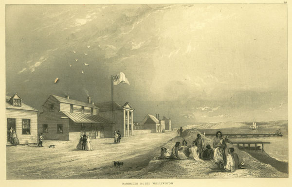
30. --BARRETT'S HOTEL, WELLINGTON.
This house was taken out from England by Dr. Evans originally, but was subsequently purchased by Mr. Richard Barrett, and opened as an hotel. It is now kept by Mr. Suistred, who has greatly improved it, and who looks and acts the host to perfection. Mrs. Suistred also, by her attention to the necessary details, contributes much to the comfort of the visitors. The projecting wing consists of a billiard-room below, and a Free Masons' hall above, and was built by the present landlord. The house beyond the hotel is Medical Hall, Messrs. Dorset and Sutton; and the hills forming the east side of the harbour and the district of the Hutt bound the view.
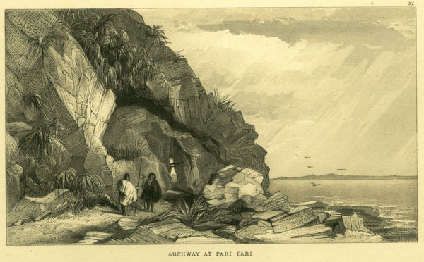
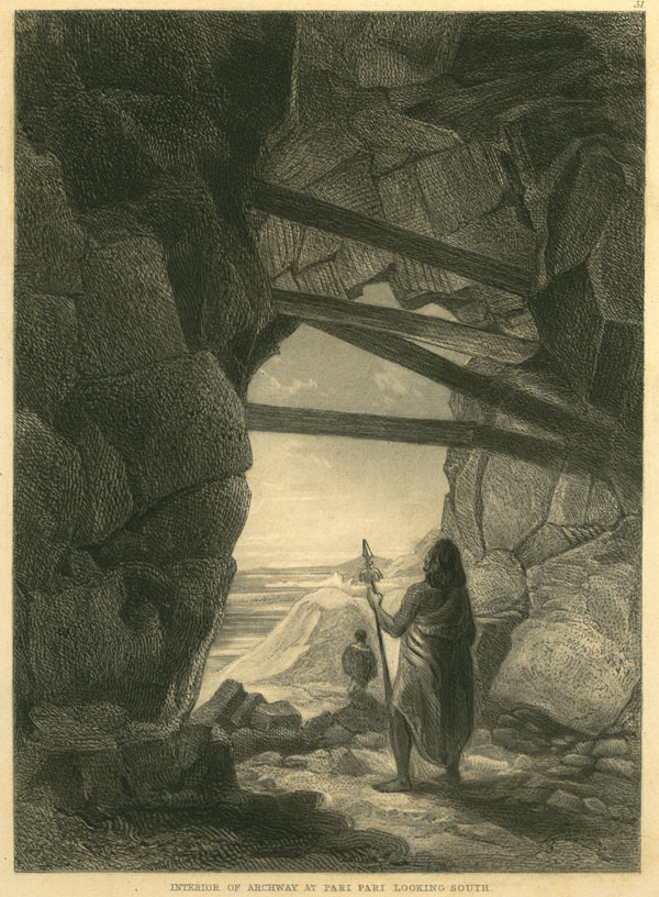
31. --ARCHWAY AT PARI PARI.
The road from Wellington to the northward is principally along the coast, which is very rocky at this part. It was carried through the rocky point shown in the Sketch. Certain portions of the Southern Island appear in the distance.
The traveller meets many natives along this road, as they are a migratory race. They are generally clad in blankets, and some few in native mats. The Maori's are large consumers of many European articles, as blankets, navy prints, tobacco, &c, and are good customers to the storekeepers in most parts. They find a great difficulty in pronouncing English words, and their wishes are made known as much by signs and gestures as by words of mouth. The author never had any difficulty in understanding their meaning, although very little acquainted with their language. The natives have learned to respect the character of many European warriors, from the whalers, by whom they have also been made acquainted with the history of Buonaparte; and they take a lively interest in our late wars. Upon Hiko, a young chief of rank, being examined by Mr. Spain, Her Majesty's Commissioner of Land Claims, he alluded in the course of his evidence to the great ruler of his own tribe, in the following terms:-- "When Rauperaha first ravaged Cook's Straits, like Blucher or Wellington, carrying victory before him;" and continued in the same strain, much to the astonishment of the Commissioner. They can generally read and write, and are fond of corresponding with each other by letter; their ideas are highly imaginative, and they do not always confine themselves to the usual style of composition, but deliver their sentiments in the shape of parables, after the manner of the Scripture writers. There is considerable etiquette displayed by the natives at a meeting of different tribes. The inferiors are obliged to advance to meet their superiors. The greatest chief preserves the most dignified bearing, and calmly waits until the lesser personages present themselves to him, which they generally effect while in the course of their address. Upon reaching him, they suddenly withdraw with a bound, and so continue advancing and retreating during the delivery of their speeches. Few of the young men are tatued at the present time; the operation being very painful, they are easily persuaded by their Missionaries to forego it. Tatuing is a regular business among them; carving in wood, and decoration, being also included by the craft, who travel far and near to embellish the persons and property of their friends. Bone instruments were formerly used, but steel tools are now employed.
The native cooking oven, called the umu, is a very curious contrivance. It consists of a round hole, about two or three feet diameter, and twelve inches deep, in which some wood is placed and lighted. Large pebble stones are then thrown on the fire and heated, which remain at the bottom of the hole after
[Inserted unpaginated illustrationS]
Drawn by S. C. Brees
Late Principal Engineer & Surveyor to the New Zealand Company
Engraved by Henry Melville
[Image of page 21]
the wood is consumed; the stones are next arranged so as to present a level surface, and sprinkled with water, and wild cabbage or other leaves are moistened and spread over them, upon which the food intended to be cooked is laid; the whole is then covered over with leaves and flax baskets, and lastly, filled over with earth, which completes the operation. After allowing it to remain a certain time, according to circumstances, which the cook determines with the utmost precision, the oven is opened and the food removed. Eels and potatoes are delicious when cooked in this manner, and every other kind of provision.
The natives of New Zealand seem fond of mourning upon the death of their relatives and kinsmen, and on numerous other occasions. They exhibit every outward sign of violent grief, and give utterance to the most dismal sighs, accompanying the same with copious tears, and scarifying themselves about the body and limbs with muscle shells. The author remembers once travelling along the coast of Palliser Bay with A Kuri and a party, and upon arriving at a fishing Pa of his tribe, called Muka-Muka, the party stopped, and immediately missed A Kuri, but soon after heard the mournful cry of the tangi proceeding from a high hill above, whither he had gone to cry for a son who had been accidentally drowned there about three years before. The sound struck very pathetic to the ear, and reminded one of David retiring to the chamber over the gate to mourn for Absalom.
PLATE 11.
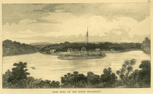
32. -- KARI KARI, ON THE RIVER MANAWATU.
The Manawatu, the Wanganui, the Patea, and the Mokau, are the most important rivers of the south-west coast of New Ulster. The wind from the sea appears to overcome the force of the current of these rivers, and bars are therefore pretty general. There is about six or seven feet of water over the bar of the Manawatu at low water, the tide rising about eight feet. The breadth of the entrance is about three hundred yards at half tide, and the Wanganui is about the same as respects its capabilities.
The Manawatu flows through a flatter country than the Wanganui, and its course is consequently the most impeded. It contains a rich alluvial soil, which is carried down from the Tarerua mountains, and some parts of its banks are rather swampy. The Wanganui takes its rise in the volcanic district of Tongariro, and a great quantity of pumice stone passes along its bed to the sea.
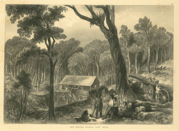
Kari-Kari is about eight miles from the coast, in a direct line, although much further by the river. The Messrs. Kebbell have put up a steam saw-mill on the banks of the river, near the Survey station, but on the opposite side, the engine being a twenty-horse power rotary engine. The unfortunate state of the land question subsequently stopped all emigration to the country land, or they would have reaped the reward of their enterprise and industry, but we trust better days are in store for them.
[Image of page 22]
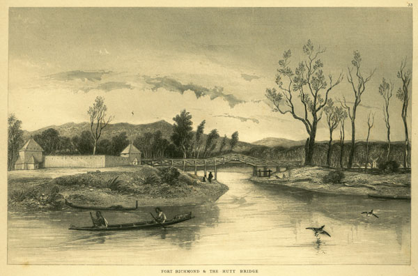
33. --FORT RICHMOND AND THE HUTT BRIDGE.
The Hutt Bridge, which was erected by the New Zealand Company, was opened in the month of April, 1844. A bridge, consisting of a single arch, was intended to have been thrown across the river, but another design, consisting of three small arches, was ultimately sanctioned and built, as sufficient for present purposes.
The View is taken looking down the stream, and shows Fort Richmond, which was constructed under the direction of Captain Compton, an enterprising settler of the Hutt. It is planned on the model of those in the United States of America, to guard against incursions of the Indians. The stockade is arranged in the form of a square of ninety-five feet, with towers of defence or block-houses at two of the opposite angles, which command the bridge and the river on both sides. It is composed of slabs of wood nine feet six inches high, and live to six inches thick, and is musket proof. One of the block-houses is fifteen and the other twelve feet square. The fort was erected at a cost of one hundred and twenty-four pounds, independent of the value of the timber, which was presented by Mr. Compton, and voluntary labour to the amount of fifty-four pounds ten shillings is included in the above statement of the cost.
The excitement which was felt at the Hutt when a party of the 58th regiment took up their quarters in the fortress on the morning of the twenty-fourth of April, 1845, will not be soon forgotten. The settlers having brought all their energies to their assistance in the erection of the stockade, had just completed it on the evening of the previous day (Sunday) when an attack was expected from the natives. The settlers accordingly determined to hold possession until the arrival of the military, which took place at about three o'clock in the morning amid the acclamations of the settlers.
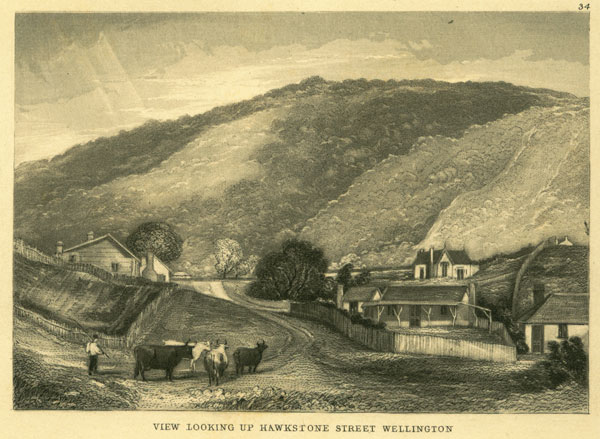
34. -- VIEW LOOKING UP HAWKSTONE STREET, WELLINGTON.
This represents the commencement of the Karori road. The house near the foreground, with the verandah, was built by Mr. Wickstead; and that next it, on the right of which only a portion is seen, was known as "Cadet's College," having been tenanted by some of the Surveying Cadets of the New Zealand Company. Mr. St. Hill's residence appears above these, backed by the Tinakore range of hills.
PLATE 12.
35. -- PORERUA HARBOUR.
This View is taken looking towards the north; a whaler, named Jackson, resides near this spot, where he keeps a ferry for the convenience of travellers.
36. --THE GREAT WAIRARAPA DISTRICT AND LAKE.
This is the View presented at the termination of the line laid out for the Hutt road, or the road from Port Nicholson to the Wairarapa. The plains below consist of fern and grass; belts of trees and forests are also spread over it. The Ruamahunga river is situated on the opposite side, and the sea lies beyond
[Inserted unpaginated illustrations]
Drawn by S. C. Brees
Late Principal Engineer & Surveyor to the New Zealand Company
Engraved by Henry Melville
[Image of page 23]
the lake to the right in the picture. There are some extensive swamps in the Wairarapa covered with high flax, or Pharmium Tenax, which, although found at nearly every part of the Islands, abounds in such places.
The flax has long been employed for shipping purposes, and the natives use it for their ropes, mats, nets, baskets, &c, and prepare it by scraping the green vegetable matter from each blade by the aid of a muscle-shell; and the white man has not yet succeeded in improving upon the native process, although there is evidently a great opening for it in Europe for numerous purposes. Each plant consists generally of upwards of fifty leaves, similar in shape to the English flax, but considerably longer, perhaps five to ten feet long, and two to four inches wide when closed. The flax presents a handsome appearance, with its graceful flower stems springing above the leaves, the blossoms of which are yellow, and much prized by natives for the sweet matter within them. The seeds contain an oil of some value, which might be made available for trade. Each blade consists of two leaves joined and doubled; they are, however, partially opened at a certain distance from the ground; the inner side is glossy and covered with a glutinous substance. The natives having cut a number of leaves from the centre of the plant, tie them in bundles, and carry them to their Pa, to prepare. Each leaf is first divided longitudinally, and a cross cut made in the middle, or otherwise near the thick end of the leaf and on the outer face, sufficiently deep to penetrate the vegetable substance on this side. The blades are next scraped on the outer face with a muscle-shell, commencing from the transverse cut, when the fibres are all that remain of the leaf. A native can scrape about 10lbs. of flax per diem, and upon a sufficient quantity being scraped, it is made into mats and other useful articles. There are several kinds of flax, and it is all known to the natives by the general name of Korari. That which grows on the hills is considered the best, although not so large as the flax found in swamps.
Much injury is done in the home-market in consequence of the difficulty, if not impossibility, of confining the natives to the cultivation of the best sort of flax. They also cut it just when it suits them, instead of the proper season of the year, which they are perfectly acquainted with. The flax was formerly cultivated with the greatest care; the finest flax, which almost rivalled silk in softness and beauty, was reserved for their best mats, but the common coarse flax is the kind supplied to the white people, so that it is highly necessary that we should possess means of cleaning it ourselves. The flax intended for fine mats also undergoes much additional labour; it is repeatedly soaked in water, beaten and twisted and dried again. There is a brittle and glossy skin always left upon it after the first cleaning, which maybe removed by hackling. Mr. E. J. Wakefield estimates this chaff-like skin at twelve per cent, of the scraped fibre: the remaining eighty-eight parts consisting of straight clean fibre and tangled tow. The expense of shipping the flax home presents a great impediment to its cultivation, and from not being understood in the home-market, the colonial merchants frequently lost money by it formerly; a remarkable change, however, has occurred at recent sales, when it realised remunerating prices, which will no doubt have its due effect upon the colonists.
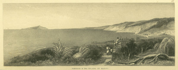
37. --PUKERUA AND THE ISLAND OF KAPITI.
Pukerua is situated at that point of the west coast where the native path from Porerua joins the beach. The View is taken from the old potatoe gardens at the top of the hill, and shows the Island of Kapiti and the west coast, with Mount Egmont in the extreme distance.
[Image of page 24]
The rivers Manawatu and Wanganui lie along this coast. Kapiti affords a good roadstead for ships in the Straits, and is a favourite place with the whalers. The following shows the distance from Wellington to Wanganui, and from thence to Teranaki.
Survey Office, Wellington,
August 19th, 1844.
Western Coast Communication.
TABLE OF DISTANCES FROM WELLINGTON TO NEW PLYMOUTH.
Miles. Chns. Links.
Pipitea Point to Kai Warra.......................1 14 0
Kai Warra to Jackson's, Porirua......................11 73 0
Jackson's Ferry, by the new road (the old road at Kai Warra is shorter by 1 mile, 8 chns., 66 links)to Thorns' Hotel..........................4 6 0
Thorns' Hotel, Porirua, measured along the shore of the harbour, (the distance across the harbour by the Ferry is shorter by 1 mile, 6 chains) to Pukerua..............6 0 0
Pukerua, through the Bush (not measured) to end of Rocky Settlement. [N. B. From. Thorns' to Pukerua, by the coast, 7 miles, 67 chains, measured distance]............3 27 0
End of Pari Pari, or the Rocky Settlement, to Wainui...............2 3 0
Wainui to Huruhi..........................5 37 0
Huruhi to Waikanae..........................1 41 0
Waikanae to Otaki..........................10 35 0
Otaki to Waito............................1 43 0
Waito to Ohau...................... .....4 40 0
Ohau to Horowenua..........................5 24 0
Horowenua to Manawatu........................9 21 0
Manawatu to Rangitiki (this and the remaining distances are not measured)........15 17 0
Rangitiki to Turakina.........................18 42 0
Turakina to Wangaehu.........................3 56 0
Wangaehu to Waiorongota........................4 58 0
Waiorongota to Kaitoki.........................0 76 0
Kaitoki to Wanganui.........................2 52 0
[TOTAL] 112 25 0
From Wanganui to Karaka........................6 20 0
Karaka to Kai-hewi..........................0 20 0
Kai-hewi to Ototoka..........................4 53 0
Ototoka to Footpath to Waitotara......................2 59 0
Footpath to Waitotara, to Waitotara.....................8 21 0
Waitotara to Wennakura........................12 59 0
Wennakura to Patea..........................2 0 0
Patea to Manawapo..........................12 0 0
Manawapo to Waokena.........................6 0 0
Waokena to Pukioha..........................5 0 0
Pukioha to Rangatapu .........................4 0 0
Rangatapu to Wai-mate.........................3 0 0
Wai-mate to Otu-matua.........................18 0 0
Otu-matua to Namu..........................12 0 0
Namu to Okau...........................16 0 0
Okau to Haurangi...........................14 0 0
Haurangi to Teranaki.........................10 0 0
Total distance from Pipitea Point, Wellington, to Teranaki, New Plymouth....249 17 0
[Inserted unpaginated illustrations]
Drawn by S. C. Brees
Late Principal Engineer & Surveyor to the New Zealand Company
Engraved by Henry Melville
[Image of page 25]
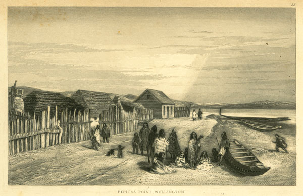
PLATE 13.
38. --PIPITEA POINT, WELLINGTON.
A native Pa is located upon this point, the situation being a favourite one with the maori's for hauling up their canoes. The Tarerua range of mountains is shown in the distance, from whence the river Hutt rises.
Mr. George Clarke, jun., the late sub-protector of aborigines, estimated the number of natives capable of bearing arms, and inhabiting the shores of Cook's Straits in December, 1843, at 11,650. Mr. E. J. Wakefield reckons them at about 8000; he also estimates the native population of both islands at considerably less than 100,000. Dr. Deiffenbach makes them rather more, as will appear by the following table:--
Table of the Tribes and Population of New Zealand.
|
|
Names.
|
Habitations.
|
Population.
|
| 1
|
Rarewa
|
North Cape to 35 deg. S. Latitude
|
8000
|
| 2
|
Nga-pui
|
Wangaroa, Bay of Islands, Hokianga
|
12,000
|
| 3
|
Nga-te-whatua
|
Kaipara, Manukao, Waitemata
|
800
|
| 4
|
Nga-te-paoa
|
Gulph of Hauraki
|
5000
|
| 5
|
Waikato
|
Manukao, Aotea, Waingaroa, Kawai, Waipa, Waikato,
Mata-mata, Mokau, Maunga, Tautare
|
24,000
|
| 6 1
|
Nga-te-awa(a)
|
Cook's Straits
|
5490
|
| 6
|
Nga-te-awa(b)
|
East Coast
|
8600
|
| 7
|
Nga-te-Wakaua
|
Muketu, Roturua, Tarawera, Wakatane
|
10,000
|
| 8
|
Nga-te-tuaretoa
|
Taupo
|
3200
|
| 9
|
Nga-te-Raukaua
|
Otaki, Manawatu
|
600
|
| 10 2
|
Nga-te-kahuhuna
|
East Coast, Turanga, Ahuriri in Hawke's Bay
|
36,000
|
| 11
12
|
Rangitane
Nga-haitao
|
Middle Island, especially at Otago
|
1200
|
|
|
|
Total
|
114,890
|
[Image of page 26]
39. --VIEW LOOKING DOWN HAWKSTONE-STREET, WELLINGTON, WITH MR. BREES' COTTAGE.
This View is taken on the rising ground at the junction of Hawkstone-street with the Tinakore, and shows a part of the Karori road. Mr. Brees' house and garden are seen below on the right, and the harbour terminates the view. The fence on the left incloses Mr. St. Hill's field and premises. The solitary Kaikatea tree alluded to in the description of subject 28 is represented near the foreground.
Although the climate of Wellington is remarkably temperate, the weather is sometimes cold; thus, on the 24th May, 1844, it was very severe, the wind being south-east; a heavy fall of snow occurred. A thermometer, hung up under the verandah belonging to the cottage shown in the View, stood at 38 deg.
40. --WESLEYAN CHAPEL AND MISSION HOUSE, WELLINGTON.
The Wesleyan Chapel at Te Aro is a tolerably large building for a young colony, being 39 feet wide and 48 feet long. Mr. Robert Stokes furnished the design for the building, which appears to be very substantially erected. The walls are formed of brickwork 18 inches thick. The chapel was opened for service in December, 1844, under the ministry of the Rev. S. Ironside.
There is an Independent Chapel at Thorndon, which was opened on the 13th of October, 1844, Mr. Woodward being the officiating minister.
The present view represents the Wesleyan Chapel and Mission House, looking in a direction towards the beach. The house occupied by the late Mr. Brewer is on the right of the road, and the large trench and mound which were formed immediately after the Wairau massacre, for inclosing in certain spots as places of refuge in case of Wellington being attacked by the natives.
PLATE 14.
41. --MORING'S CREEK. PITONE AND THE HON. HENRY PETRE'S RESIDENCE IN THE DISTANCE.
This View is taken on the banks of the Hutt, near Pitone. The land shown on the right is rather swampy, but is being drained and brought into cultivation by the Hon. H. Petre, whose residence and premises are shown on the right. The toi-toi, which supplies the natives with reeds for the lining of their warre's, fringes the creek; and, together with the flax plant, is always found on swampy ground. The hills at the back of Wellington are in the distance.
[Inserted unpaginated illustrations]
Drawn by S. C. Brees
Late Principal Engineer & Surveyor to the New Zealand Company
Engraved by Henry Melville
Drawn by S. C. Brees
Late Principal Engineer & Surveyor to the New Zealand Company
Engraved by Henry Melville
[Image of page 27]
42. --BANKS OF THE HUTT NEAR MR. MOLESWORTH'S FARM.
This is a scene on the banks of the Hutt, opposite Mr. Molesworth's farm-house and jetty. The tree overhanging the river is called the Ti, or cabbage tree. Bunches of fibrous leaves, like dwarf flax, grow at the extremities of the branches, and at other parts. Kohai is another tree found on the banks of rivers, and which is covered in due season with yellow flowers. The wood is black in colour, and exceedingly hard and durable. When it is found with Howeri and Manauka it is a sure sign of low land subject to floods. The latter tree furnishes a hard wood, which is much esteemed for fuel when perfectly dry.
The native canoes are formed with much labour out of a single tree, generally of totara, and with the axe and adze, in the use of which the natives are very expert. Those used for war or carrying purposes are from seventy to eighty feet long, and furnished with gunwhales and ornamental prows and stems, which are fastened on with flax. These canoes will carry fifty or sixty men, who all paddle and keep time together by songs. The chiefs generally take the steering paddle at the stern, standing upright and giving the time to the rowers.
43. --THE EXCHANGE, WELLINGTON.
This part of the town is called the head of the bay. The large building shown in the View was long used as an Exchange and Reading Rooms, and as a sort of Town Hall for public meetings. Messrs. Ridgway and Guyton's jetty is shown close to it, beyond which is Captain Rhode's and Messrs. Simmons and Hoggart's Windmill. Te Aro Pa, and Mount Victoria occupy the distance.
PLATE 15.
44. --PALLISER BAY AND THE SAND BAR OF THE WAIRARAPA.
This View represents Hokorewa Pa and the Bar of the Wairarapa. The Ruamahunga River is shown with its passage open to the sea, but it is closed for upwards of half the year. The river maintains its channel through the lake, and forms a good communication to the upper part of the district. Port Nicholson is situated on the other side of the range of mountains shown in the distance. The whole of these tables and plains appear of much more recent formation than the hills; large beds of lignite wood are exhibited in the sections of the cliffs along the beach. The wood is of the same kind as the present trees of the country, and appears but little changed. The author has picked out pine seeds from among it, which must have belonged to the Kouri, as it is the only pine in the country that bears them, although this tree does not grow in this part of the island at the present day. The lower strata consists of thin loamy beds of clay, with large round blocks of septarian limestone among it; the upper parts of the cliffs assume more the character of sand.
[Image of page 28]
45. --VIEW OF PORT NICHOLSON, FROM THE RANGE OF HILLS WEST OF THE OHIRO VALLEY.
The Ohiro Valley runs from the sea in Cook's Straits to near Te Aro Flat, Wellington, and is known in the colony as the "Happy Valley." A line view of the straits and entrance to Port Nicholson is obtained from the hills inclosing it, which is represented in the Plate. The range of hills in the distance form the east side of the harbour. Mount Victoria, Evans and Lyall Bays, and the Tarerua range of Snowy Mountains, which inclose Port Nicholson, and terminate at Point Turakirai, are delineated in the View. Dr. Deiffenbach estimated these mountains at about 3000 feet high, which is probably under the mark. They are wooded nearly to the top. The author believes he has penetrated further up the river and valley of the Hutt on the Tarerua Mountains than any other traveller, and he found their general character to be very steep, covered with forest, and to consist of several parallel ranges, with mountain torrents between them, of no great importance except in flood time, when the water rises with extreme rapidity, just as rain collects in the gutters of a roof, perhaps ten or twelve feet in an hour. Sometimes the bed of the river becomes blocked and dammed up by an interruption of hard trap rock uplifted across its bed, in which case a large body of water collects and forms a pond of sufficient depth to float a man-of-war, and which precipitates itself to the lower level by a lofty waterfall. The scenery is very grand and imposing, as may be readily conceived.
46. --RESIDENCE OF WM. SWAINSON, ESQ., F. R. S., AT THE HUTT.
Mr. Swainson is settled with his family on Section 31, of the Lower District of the Hutt, and has been in the midst of difficulties with the natives almost from the commencement. Impelled by his love of the country "to face the bush" much sooner than ordinary colonists, he became almost a marked man with them; but now he will reap the reward of his labours, his troublesome neighbours having been driven away. The late outrages of the Porerua natives, and their attack upon the soldiers and settlers, took place close to his house, which is situated between Fort Richmond and Mr. Boulcott's farm.
PLATE 16.
47. --COLONEL WAKEFIELD'S RESIDENCE, WELLINGTON.
The residence of Colonel Wakefield, the principal agent of the New Zealand Company, is built on one of the public reserves, and in a very prominent and commanding position. The drawing is taken, looking towards the head of the bay, and shows Wellington Terrace winding up the hills, separating Thorndon from Te Aro flat, and which is studded with neat dwellings and gardens. The Colonel's garden, although very much exposed to the wind, contains many choice trees and plants, and is kept in nice order.
[Inserted unpaginated illustrations]
Drawn by S. C. Brees
Late Principal Engineer & Surveyor to the New Zealand Company
Engraved by Henry Melville
Drawn by S. C. Brees
Late Principal Engineer & Surveyor to the New Zealand Company
Engraved by Henry Melville
[Image of page 29]
48. --KAI-WARRA SAW-MILL.
This mill is situated on a tributary of the Kaiwarra-warra, and upon a section belonging to Captain Daniell. It was undertaken by four enterprising millwrights, and the works were completed in the month of October, 1842. The same parties first attempted to establish themselves near Porerua Harbour, and leased four sections for the purpose of carrying out their views, but having built a wa-re, and commenced operations, they were turned off, in the month of April preceding, by Rangihaeata and his followers, who destroyed all they had done. The Kai Warra mill consists of a water wheel placed athwart the stream, which works several circular saws, and the water is dammed up above, to maintain the requisite head.
49. --THE BANK, WELLINGTON.
This View is taken from the corner of Mr. Jenkins' tavern; the bank is close in the foreground. The premises next the harbour were formerly Mr. John Wade's stores, but are now occupied as barracks.
PLATE 17.
50. --MOUNT VICTORIA, WELLINGTON.
There are four mills for grinding corn in Port Nicholson--viz., Mr. Catchpool's steam-mill, which was taken to the Colony by Dr. Evans, and at work so early as October, 1841; Messrs. Simmons and Hoggart's windmill, which is represented in the View, each with one pair of stones; Mr. Molesworth's new windmill in the valley of the Hutt carries two pair; the fourth, near the mouth of the Kai-Warra-Warra stream, also has two pair, turned by water power, and the works have been recently completed by the proprietors, Messrs. Mathieson and Schultze.
Messrs. Simmons and Hoggart's motive power is the wind, but the motion is conveyed to another building, where the mill-stones are fitted up. A road is formed up to the top of Mount Victoria and to Evans' Bay. The cottage shown at the foot of the hill, called Victoria Cottage, is the farm residence of Wm. Fitzherbert, Esq. The flax-plant luxuriates about this locality, and is represented near the foreground.
51. --INTERIOR OF ARCHWAY AT PARI-PARI, LOOKING SOUTH.
This is the same archway that formed the subject of No. 31. The present View is taken en route to Manawatu, and the former as it appears in returning to Wellington. The rocks are principally composed of argillaceous slate with sharp edges and hard wacke, almost black in colour, and without petrifactions of any kind.
[Image of page 30]
52. --PARAMATA PA, PORERUA.
This View shows a part of Paramata Pa, Porerua Harbour. The poles stuck up in the water by the beach are fixed for the purpose of assisting in catching fish. The Pa's are always inclosed in a sort of stockade, with stiles at the entrances. The fire-wood is stacked by the side of the fences, some of which are shown in the View.
PLATE 18.
53. --THE BEACH NEAR MAJOR BAKER'S RESIDENCE, WELLINGTON.
This represents a portion of the road to Pitone. The roof only of Major Baker's house is seen peeping above the bank by the side of the tree. The road to Wade's Town is shown at the point where it leaves the beach, and the Red House or Barracks above it. Some of the houses towards Kai-Warra-Warra appear in the distance.
54. --MAKAENUKU PA. DISTRICT OF THE HUTT.
This Pa has been built, and the extensive potatoe grounds around it cleared entirely within the memory of the present settlers. It was occupied by the Porerua and some other troublesome natives, who acknowledged Rauperaha and Rangihaeata as their chiefs. The former is considered the Ariki or chief ruler of the tribes, inhabiting the west coast of Cook's Straits. These intruders are, however, driven away at last, never, it is to be hoped, to molest the settlers more.
The natives generally live together in small fortified villages, called Pa's, which are inclosed with stockades and trenches. They are sometimes built of great strength and on elevated spots. These Pa's, which are presided over by a single chief, frequently contain from 1000 to 2000 maori's; they consequently comprise a large number of subdivisions and alleys within, as each family has a separate inclosure, in which there are one or more huts built. Low bars are laid across the entrances to keep the pigs in or out, as may be desired; and no Pa is to be found without pet pigs and numerous dogs, and not unfrequently cats and fowls.
The name of Kainga is given to an uninclosed settlement, which consists of a few huts only. The native huts are very low, particularly the side walls. There is a sort of covered entrance to some, formed by the prolongation of the roof at one end beyond the wall of the house. This portion may be called the portico or verandah, and is very tastefully lined with reeds and ornamented with curious barge boards and carving next the roof, which is painted over with red ochre. The native carving bears a greater resemblance to ancient Greek scroll-work than that of any other country. The author has frequently observed scrolls, frets, volutes, and other ornaments exactly resembling those found on Etruscan vases and other antique remains. Their curves also invariably partake of the Greek character, and consist of ellip-
[Inserted unpaginated illustrations]
[Image of page 31]
tical lines, with the same baldness as respects relief. It is not, however, quite so severe, and most of the maori carving may be designated debased or brutalized, and bears the same relation to early Grecian as Norman ornaments do to late Roman works. The author remembers to have seen an ornament used for the prow of a canoe, precisely similar to the Grecian Ionic angular volute, and formed with two faces, the thickness between them being hollowed out by a similar section. The position of it, however, was inverted. Most of the volutes are also composed of two or more scrolls inscribing and circumscribing each other, which is the characteristic of Grecian scroll-work. Although this peculiarity had never been remarked by any previous writer or traveller, yet, upon being pointed out to different parties in the colony, they perceived it instantly: perhaps it may afford some cue to the numerous speculations respecting the original country of the maori's; their traditions state that they came from the eastward in vessels of much larger size than their present canoes.
Whether they came by sea, or the land has become submerged beneath it, and insulated spots or islands left at parts with the original inhabitants upon them, the author must leave to more learned heads to determine, merely testifying to the above remarkable coincidence respecting their carving, and expressing his belief that it is too great to ascribe to accident.
The better sort of native wa-re, and those built for white men by the natives, are tolerably good houses. They are formed with uprights or posts of totaro timber about two feet broad and six inches thick, which are placed at regular intervals of about five feet, and let into the ground. A plate of timber is passed along the top of these uprights, upon which the roof rests; the latter is generally hipped in large dwellings, and bears some resemblance to the thatched roof of an English cottage. Two tie beams are generally laid across the house, and one or two poles ornamented with carved figures are set upright on the ground, and employed to give extra support to the ridge-piece. The sides of the house are neatly covered with reeds, and the top substantially thatched in the native fashion, which keeps out the rain very effectually.
A house answering this description was erected near the mouth of the Manawatu for a man named Burr, and cost between 20l. and 30l. in goods. It was 36 feet by 22 feet, and occupied twelve natives about a month to build. The office at the Survey Station at Kari-kari is 30 feet by 20 feet, and cost nine pair of blankets. The expense of doors and windows is not included in either instance.
The natives sleep side by side within the wa-re, wrapped up in their blankets or mats. The cooking is performed in another house or in the open air. Provisions, seed potatoes, &c, are stuck up on high posts, to keep them secure from the rats, and assume the appearance of large pigeon-houses. The bodies of deceased chiefs and relatives are also sometimes elevated on high biers, where they remain until perfectly decayed.
The natives do not always reside at the same Pa, but visit certain places in rotation, which is regulated by the crops belonging to them. Most of the Pa's at the mouths of rivers are only used for fishing places during the season. The maori's are also much engaged in visiting and in receiving visitors, and are fond of a change. Some of the tribes on the west coast, opposite Kapiti, cross the Tarerua Mountains once a-year to see their relatives in the interior, when the news is freely circulated among them.
The distribution of suitable books among the natives in their own language would be of immense service, and, next to a demonstrative force to secure a proper respect to our laws, should form the most important subject for the consideration of the local government. It is well known that, whoever can speak
[Image of page 32]
the maori language well, and is perfectly acquainted with the native customs, is able to do almost anything he pleases with them; they are always open to persuasion, and by the medium of books, which they are very fond of reading, their minds might be brought to understand us and the advantages of our laws.
55. -- THE BARRACKS AT THORNDON, WELLINGTON.
The house at present occupied as barracks at Thorndon was built by Mr. Cooper, of the Thistle Inn. It is a substantial brick building, and was long known in Wellington as the Red House. The beach and Wade's Town road are shown, also the Jackawai Pa on the side of the hill. Kai-Warra-Warra appears in the distance, where the vessel is lying.
PLATE 19.
56. --THE CATHOLIC CHAPEL, WELLINGTON.
The Catholic Chapel is situated at Te Aro, near the beach. The Catholic Pastor is represented by the Rev. Father O'Reily, who is highly respected among his FLock, as well as by all who have the pleasure of his acquaintance. The road shown to the right in the Plate leads from the beach along the sides of the hills to Wellington Terrace.
57. --THE COURTS OF JUSTICE, WELLINGTON.
The present building was adopted for the Law Courts upon the old Courts being destroyed by fire. It was also used for the celebration of Divine Service on Sundays previous to the erection of the present Church. The house next to it, forming the corner of a street, is the Thistle Inn, kept by Mr. Cooper, The View also shows the line of communication towards the beach and head of the bay.
[Inserted unpaginated illustrations]
[Image of page 33]
The equable nature of the climate of New Zealand, may be judged of by the following table:
Meteorological Table taken from a Register kept at the Survey Office, Wellington, in New Zealand, From February, 1841, to January, 1842.
Mean Annual Temperature, 58.2.
Mean Annual Range, 4.6.
Quantity of Rain in 10 Months, 34.49 inches.
Number of Rainy Days in 10 Months, 133.
Number of Days on which the Wind was from N. or N. W., 202 days.
Ditto ditto from the South or S. E., 141 days.
58. --RESIDENCE OF THE HON. FRANCIS MOLESWORTH, AT THE HUTT.
This View shows the back of Mr. Molesworth's house at the Hutt, and the Stables, &c. It is taken from the Log Bridge, which is carried across a small creek near the premises.
[Image of page 34]
PLATE 20.
59. --PITONE PA, PORT NICHOLSON.
Upon the arrival of the first settlers at Port Nicholson they pitched their tents along the beach near E Puni's Pa, or Pitone, which is represented in this View. Some of the large-roofed wa-re's were built for the settlers by the natives, and occupied by them until their removal to Wellington, the town having been originally laid out at this part, but subsequently removed to Pipitea. The large wooden building shown to the left in the View is the Native Chapel, and the hills beyond form the east side of the district of the Hutt.
60. --TINAKORE ROAD, WELLINGTON.
This Drawing is taken from about the top of Hawkstone-street, and looking up the road in a direction towards Karori. The neat cottage shown on the right is the residence of Mr. N. Levin, and the villa seen above it, Mr. A. Holroyd's. Mr. Dorset's house may also be observed higher up the Tinakore range of hills.
61.--RESIDENCE OF HIS HONOUR, JUDGE HALSWELL, AT OHIRO.
This View is taken on Section 28 of the Ohiro District, which is a very beautiful spot. If the house should ever be completed as the learned and tasteful owner intended, it will have a truly English appearance. The entrance hall, which is both large and lofty, is at present used for a kitchen, and the author will not soon forget the chimney, which was of very ample proportions. The section is moderately hilly, and the soil good.
The rapid, and, in some cases, remarkable growth of vegetation in New Zealand, is to be attributed more to the climate than to the soil. The general depth of the vegetable mould on the hills round Port Nicholson is from six to nine inches; the sub-soil is generally a hazel loam; some of it, however, consists of a cold siliceous clay, and requires chalk or lime, of which none is found sufficiently handy. The breeding of cattle should therefore be extensively promoted, for the sake of manure. The colonists do not understand the best method of managing their farms yet, the absence of frost so completely changing the natural phenomena connected with the ground.
PLATE 21.
62.--MESSRS. CLIFFORD AND VAVASOUR'S CLEARING, PORERUA BUSH.
This Drawing will give the English reader some notion of the forests of New Zealand. It is taken on the road from Wellington to Porerua, on section 2 of the Porerua and Kinapora District, and the cottage shown was built by Mr. Skipwith. The trees represented being principally the rimu, or red pine, are small compared with many others.
[Inserted unpaginated illustrations]
Drawn by S. C. Brees
Late Principal Engineer & Surveyor to the New Zealand Company
Engraved by Henry Melville
Drawn by S. C. Brees
Late Principal Engineer & Surveyor to the New Zealand Company
Engraved by Henry Melville
Drawn by S. C. Brees
Late Principal Engineer & Surveyor to the New Zealand Company
Engraved by Henry Melville
[Image of page 35]
63. --THE BEACH AT TE ARO.
This View is taken looking up the beach towards Pipitea, and shows some of the stores and shops, comprising those of Messrs. Sutton, Lyon, Boulcott, Wallace, and others.
64. --SCOTCH KIRK, WELLINGTON.
The Scotch Church was opened for Divine service on the 7th January, 1844, under the auspices of the eloquent Rev. John M'Farlane.
A considerable fire occurred at Wellington on the 9th November, 1842, when fifty-seven houses, comprising twenty wooden ones, extending along the beach from near Barrett's Hotel, were consumed; the flames proceeded towards the head of the bay, until they were intercepted by the point known as "Clay Hill," or "Windy Point," which is the point just beyond the Chapel shown in the View, otherwise the bonded stores and warehouses at the head of the bay would have probably shared the same fate. Disastrous as the fire was to many, yet it has proved beneficial in some respects, for the old raupo wa-re's and toi-toi roofs have been replaced by substantial brick stores and buildings. The total damage done has been estimated at 16,000l.
THE PANORAMA PLATE.
PANORAMA OF WELLINGTON, PORT NICHOLSON, TAKEN UPON THORNDON FLAT.
This Panorama is taken from the terrace in Dr. Evans' garden, whose residence is shown in the foreground upon the left. Upon looking to the right of it, the eye ranges across Thorndon Flat: the first dwelling below the hill is occupied by Mr. Mocatta, and is close in the foreground. The houses seen beyond, comprise the New Zealand Company's Survey Offices, Stores, and the Emigration Houses; Messrs. Clifford and Vavasour's Establishment, &c. &c.; beyond which, in the distance, is the Valley of the Hutt. The road from Wellington to this district skirts the hills shown on the left.
Now let us pass to the right of Mr. Mocatta's; we perceive, first, a large group of houses, consisting of the Supreme Courts, Major Richmond's, and the Government Offices; the Thistle Inn, Major Hornbrook's Stores, &c.; and a little further still to the right, the back of Barrett's Hotel may be observed by the side of the harbour. Continuing to turn in the same direction as before, we see Mr. Fox's, which is the house situated under a vessel sailing in Lambton Harbour; Colonel Wakefield's residence, with the flag-staff, is a little further to the right, on rising ground, and at a greater distance. Passing on, the eye ranges down the beach and discovers the houses at Kuma Toto; Windy Point a little beyond, and Te Aro Flat in the distance.
The large roof seen just to the right of Colonel Wakefield's flag-staff, is the Church of England, and the foreground on this side is finished by the residence and grounds of Mr. Chetham Strode, which joins Dr. Evans' premises.
The hills seen to the right in the View are the Tinakore Range. Those on the opposite side, extending nearly across the Picture, comprise the east side of Port Nicholson and the entrance, Evans' Bay. &c.
[Image of page 36]
Mount Victoria appears situated over Barrett's Hotel; and Mount Albert, where a telegraph is erected to give notice to the inhabitants of Wellington of the presence of vessels in Cook's Straits, comes just above Mr. Fox's residence.
TE ARO FLAT, WELLINGTON, FROM NEAR CAPTAIN SHARPE'S RESIDENCE.
This View shows the head of the Bay, as it is called in the colony, with the Merchants' Stores, &c. Commencing from the left side of the Picture, a rather wide thoroughfare, called Manners Street, may be observed, inclining upwards from near the lower corner of the Picture.
Suppose we pass along it. The first mass of houses occurring on the left, having one larger one with five windows in front, comprise the Southern Star Inn, the premises of the Meat Company, Billiard Room, and Mr. Edward Taylor's Store, which is at the corner of the street. Proceeding on, we pass Fuller's Hotel and the Theatre on the right, next Messrs. Waite and Tyser's Stores, terminated by a jetty at the waterside on the left, Mr. Fitzherbert's Stores being behind these. The large building and premises, also connected with a jetty beyond, on the left of the road, are Messrs. Ridgeway's, Guyton and Hickson's Stores.
The Wesleyan Chapel is the next building, sufficiently large to be made out in the View, which is on the right in proceeding along the road; Captain Roades' Stores and jetty are further up on the left, and Te Aro Pa may be just recognised beyond them.
The mass of houses near the middle of the Picture comprises the neighbourhood of Willis Street, &c.
Mount Victoria may be observed in the background, over Messrs. Ridgeway's Stores; Jerningham Point, and Evans' Bay, being to the left of it.
The houses in the right side of the View, nearer the foreground, are Messrs. Stokes' residence and premises, also Mr. Strang's.
PANORAMA TAKEN FROM THE TOP OF MOUNT VICTORIA, PORT NICHOLSON.
This View requires to have been delineated on a larger scale, but we hope it will not be uninteresting to our readers as given.
Commencing from the left, we see the head of Evans' Bay and Lyall's Bay beyond it, with the sandy-strip of land separating them. Burnham Water, and the entrance to Port Nicholson from Cook's Straits, are also shown over this part.
Passing on to the right, we see the ranges of hills enclosing the Port Nicholson districts on the westward, which extend to the other side of the Picture, and terminate in the Tarerua Mountains up the Hutt; and Somes' Island may be perceived below the latter.
The portion of the Town of Wellington that can be made out, consists of the head of the Bay, which is represented in the last View. Pipitea Point, with Thorndon Flat, may also be perceived beyond this, to the right. The hills seen in the distance in the middle part, are near Porerua.
T. C. Savill, Printer, 4, Chandos-street, Covent Garden.