CHAPTER VII. SECOND VISIT TO WAITEMATA (concluded) FELTON MATHEW'S REPORT
[Image of page 157]
CHAPTER VII.
SECOND VISIT TO WAITEMATA (concluded)
FELTON MATHEW'S REPORT
[Upon his return to the Bay of Islands, Mathew presented to Captain Hobson a lengthy report on the results of his survey, dated June 15th, 1840. The earlier part of this is given in precis form, but those sections which deal with the Waitemata demand fuller treatment.
(i) Whangarei. After a close description of the harbour and district of Whangarei, Mathew came to the conclusion that this place was unsuitable for the site of the principal settlement, the amount of level land being inadequate for building purposes, and the upper portion of the harbour not having a sufficient depth of water. But he recommended a spot on the north shore, where the river entered the Bay, as suitable for a small settlement.
(ii) Mahurangi. He was more favourably impressed with Mahurangi, which he thought formed a desirable site for a Town and which had a good harbour. Communications could be opened up westwards to the Kaipara and southwards to
[Image of page 158]
the Waitemata and the Manukau. In discussing this site, he defined the desiderata for the capital as consisting of a good anchorage close in shore, sufficient level land for the Town close to the shore, facility of communication with the interior, and an adequate supply of timber, water, building-stone, etc., in the vicinity. Mahurangi did not fulfil all these requirements; the land available for building was limited in extent, internal communications over the hills of the dividing range might present some difficulties, though not insuperable, and there was the possible objection that it was too far north and too near the Bay of Islands. Nevertheless, it might serve if no more desirable place were to be found; and in any case, Government should obtain possession of the harbour and surrounding country with a view to forming a flourishing secondary settlement.
(iii) Between Mahurangi and the Waitemata he reported there was no practicable harbour.
(iv) Waitemata and (v) Tamaki. The full text of the report is given.]
4th. Having thus minutely examined the coast as far as "Waitemata," and particularly those portions of it to which, by his Excellency's instructions, my attention was more especially directed: I now applied myself to a careful and deliberate examination of that harbour and of the spot which I once on a previous occasion visited in company with his Excellency, and which at first sight, appeared to present some advantages which were likely to render it available for the purpose I had in view.
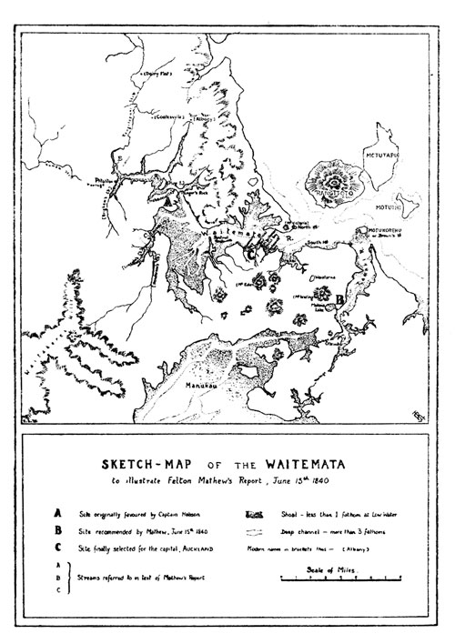
The principal tributary of the "Waitemata" (marked A on the accompanying Sketch No. 2) 1 and which forms
[Inserted unpaginated illustration]
[Image of page 159]
the Northern boundary of the spot I allude to, I ascended as far as I conveniently could, in my boat. At a distance of about four and a half miles from the entrance, I arrived at a ledge of rocks, which at low water constitutes a fall of about three feet, but may be passed at half flood. The river thus far extends in a direction nearly Eastward, diminishing gradually in breadth, and shoaling from three fathoms to eight feet. Above the fall it turns abruptly to the Northward, retaining an average depth of from eight to ten feet a distance of about three miles, where another ledge of rock occurs, above which the river becomes very narrow, its course extremely tortuous, and only navigable for canoes. The whole mass of country between the river and the Eastern coast, is extremely rugged and impracticable, the soil is of the most sterile description, producing only a scanty growth of stunted fern, with occasional masses of Forest in which is a sprinkling of Koudi Timber. This stream is connected by a short portage, 2 with a branch of the "Kiapara," and is used by the natives as a means of communication between that place and "Waitemata." A branch of this river (marked B in the sketch) bears to the Northward, and I was anxious to examine it, under an impression that it might open a means of communication with the country at the back of "Mauranghi"; I found, however, that at a distance of about three miles, it separates into three branches, one bearing to the Eastward, the others to the Northward and Northwest. In the latter is a fall of about fifteen feet; the stream is very narrow, and navigable only for canoes. In fact none of the streams could become available, as a means of internal communi-
[Image of page 160]
cation, without a large expenditure of money and labour.
At the junction of these streams, there is a rather considerable extent of fine land, well adapted for small farms. 3
To the Eastward the Range which divides these waters from the coast, is broad and level unincumbered with Trees, and affording I have no doubt a very practicable road, from the north side of Waitemata, Northward, along the coast to the back of "Mauranghi." 4
The spot to which I have alluded, as having on a former occasion attracted the attention of His Excellency, is almost insulated on the Northwest side, by a sort of estuary or branch of the principal stream which is nearly dry at low water 5 --and on the south, and partly on the East side, by the Bay which is there so extremely shallow, as to render the shore almost unapproachable, even in a boat, and at high water. On the Northeast side, there is a fine and deep channel, extending along the northern bank of the river; but two fathoms cannot be obtained nearer to the South Bank, than from one to three hundred feet. The extent of the frontage, however, which possesses even this advantage is inconsiderable and does not exceed half a mile. From the Southwest side of the Bay, extends another stream (marked C on the sketch) 6 which bears in a southwest direction, a distance of about three miles, where it is obstructed by a fall of about three feet, from whence it turns abruptly to the west and then to the Northward, so as almost to insulate the portion of country which I am
[Image of page 161]
attempting to describe. This stream has a narrow channel of about two fathoms at low water; but the banks are so obstructed by mudflats and mangrove swamps, as to render landing impossible except at high water, and even then they cannot be approached without difficulty. The land on the whole of this Peninsula is of the most sterile and desolate description, being composed of a sour red and white clay --the fern is dwarfish, and thinly scattered, the surface chiefly covered with rushes, varied by an occasional patch of stunted Scrub. There is only one small running stream of fresh water to be found which is marked D on the sketch, 7 and is at a distance of several miles: the land being of such trifling elevation, and rising so gradually from the shore that the water stagnates in the Ravines and hollows, forming reedy swamps by which every undulation of the ground may be distinguished. This circumstance I consider a very manifest disadvantage, as it would not admit of sufficient drainage, a desideratum of primary importance in selecting the scite of a town. Water it is evident could be obtained on this spot only by sinking wells, a very difficult and expensive process in an infant settlement. Firewood might be obtained from the opposite shore, but necessarily at an increase of cost; brick earth is abundant throughout the Waitemata.
Proceeding farther inland the country rises into bold and lofty undulations, having almost the character of Table Land, but still of the same description, and presenting as unpromising an aspect as it is possible to conceive.
Between the sources of the two streams C and D it is connected with the lofty and thickly wooded Range 8 which forms the boundary between the Eastern waters, and the Western Coast, and which terminates at or near the North head of the harbour of "Manukao."
[Image of page 162]
From this circumstance it is evident that a land communication from this Peninsula southward could not be effected without considerable difficulty. A road extending westward along the ridge, so as to head the stream C, must necessarily be carried across all the spurs from the dividing Range above alluded to, as well as all the Ravines by which they are intersected; and if carried more to the southward to cross the stream C it would be by a long and difficult descent: and would involve the necessity of carrying a bridge across the stream, a work of considerable labour and expense. This last would, however, be the preferable plan to adopt. 9
After a most careful, anxious and deliberate examination of the portion of land to which I have been for some time alluding, I am compelled to arrive at the conclusion that it is totally unfit for the scite of the principal Settlement, and indeed ill adapted for a settlement at all. Its disadvantages may be thus summed up. It has neither wood, nor water--the land will not admit of sufficient drainage, the fall being so trifling that in wet weather, it would be little better than a quagmire--there is no stone or material for forming roads and streets within a very considerable distance, and the streets without a good coating of hard material would be impassable at almost any time--the communication with the interior is difficult--and its shores on every side but one (and that of very trifling extent) are surrounded by shoals and mud flats and quite unapproachable even for boats. Its only advantages are, that the ground is level, and in that respect suitable for building-- that a small portion of its northeastern shore is approachable within a short distance by shipping--and that it affords
[Image of page 163]
a supply of brick-earth; which latter advantage, however, it enjoys only in common with every other part of the country. I am well aware that difficulties of the nature, to which I have alluded, would be of very trifling importance where the means of overcoming them were easy of attainment, since in the formation of roads for instance, there are few obstacles, which a little skill and injenuity will not suffice to overcome; such difficulties therefore would not be of sufficient importance to disqualify for the scite of a Town, a spot which in other respects was desireable. But in an infant Colony, and more especially one in which capital and labour (the latter more particularly) are likely to be both scarce and valuable for some time to come, I cannot but consider the objections I have enumerated as of great importance, and I am anxious to set them distinctly before his Excellency the Lieut. Governor, in order that due weight and consideration may be attached to them.
I beg further to observe in connexion with this subject, that this part of the harbour of Waitemata, does not appear to be nearly so desireable for shipping, as on my first partial examination I was disposed to imagine. The channel, although deep, is narrow and when the wind blows freshly from the west or Southwest, across the Bay, it would be impossible for any number of vessels to lie there, without being moored, or incurring a great risk of getting foul of each other. Nearly in the centre of the channel, and exactly off the mouth of a large estuary extending to the Eastward, is a very dangerous rock, visible only at low water spring tides, on which the Cutter struck, but fortunately, without sustaining injury. It is about one hundred feet long by forty wide, and is composed of very hard grey stone, bearing a strong resemblance to Limestone; I have named it on my sketch the Ranger's Rock.
I examined very minutely the whole of the extensive Bay into which the harbour of Waitemata opens westward
[Image of page 164]
of the "Centinel" and found it a succession of mere sand banks and mudflats and mangrove swamps. There is a narrow and very intricate channel from the mouth of the stream which I have before described (marked C) and another from the mouth of a small Creek at the South East side of the bay; they are both of them very difficult and only fit for boats and canoes and with these exceptions there is scarcely water enough in the Bay to float a boat.
5th. Having been thus disappointed in my expectations of finding a suitable scite in this part of the Waitemata, I proceeded to the mouth of the River known by the name of the "Tehmaki" as the nearest place in which I might hope to discover anything favourable to my views. I was not long in perceiving that the chief difficulty to be encountered in this river is at the entrance, which is defended on the West side by a Bar composed partly of a sandbank which extends entirely across the mouth of the River. There is a good channel having three fathoms at low water, close up to the bank, which has only one fathom at low, and about fifteen feet at high water: at which time therefore any vessel drawing twelve feet may enter with ease and security.
The Bar is not above two or three hundred yards across, and the water then deepens immediately to five fathoms and retains a depth of five, six and seven fathoms in a very good channel for a distance of several miles. The Columbine missionary schooner, and several other small vessels, are in the habit of frequently visiting this river. On the Eastern side of the entrance, there is a deeper channel: but it is obstructed by rocks; a reef extends from the Island of Koreho, perhaps nearly to the mainland. This passage is therefore somewhat dangerous, but probably, when it has been minutely examined, and the dangers well defined it may prove the best entrance to the River. I have the honour to enclose a sketch (No. 3) of this river on
[Image of page 165]
which I have shown the soundings (taken at low water) by which his Excellency will perceive that there is abundance of water for vessels of any size, to lie close alongside the rocks for the purpose of discharging their cargoes.
There is a space of about a mile and a half on the West, and about half a mile on the East side, which is available for this purpose--the banks being of a moderate elevation, and composed of a description of Rock, which would admit of being excavated with great facility. About three miles from the mouth, the River (as will be seen by the sketch) contracts suddenly to a narrow pass where there is great depth of water entirely from shore to shore; at this point, a branch extends to the West through a narrow rocky gorge, having three fathoms water for a distance of little more than a furlong when it opens into a romantic little basin or Lake of about a mile in diameter, having, however, a depth of only six feet, even in the centre. 10 The soil in and around this spot is volcanic and of the finest description, free from trees, but covered with luxuriant growth of fern and brush. The land rises in a succession of bold, but gentle undulations to the base of a lofty Volcanic Mountain 11 of which they [form] the spurs, the intervening ravines and hollows affording an abundant supply of fresh water.
There is a Lagoon of fresh water at a distance of perhaps two miles, 12 whose waters appear to feed a small Creek which joins the principal streams near the Huts which are shewn on the sketch. I could distinctly perceive this Lake, and trace the course of its waters from the summit of the mountain (which I ascended), but the difficulty of travelling on foot is such that I was unable to reach it. From the summit of this Mountain (which I obtained with
[Image of page 166]
infinite labour, on account of the impenetrable nature of the brush) I enjoyed a splendid view of the surrounding country. I could distinctly mark the portage from "Tehmaki" to Manukao, 13 and the whole of that Harbour to the heads, and the open sea on the West coast--the country between the Manukao and Waitemata and the courses of all the streams which I had examined to the Northward; to the Southwestward I could trace the course of the River "Waikato" and the elevated land intervening between its waters and those which flow into the Frith of Thames.
The bird's eye view of the country, which I thus obtained, impressed me more forcibly than ever, with a sense of the immense importance of this isthmus, which would seem destined to become the connecting link between the Northern and Southern portions of this Island.
It appeared to me--and subsequent examination, as well as all the information I have been enabled to acquire from others, confirms the hypothesis--that the whole mass of country southward of "Manukao," and the Frith of Thames, and between the highlands on the Eastern, and that on the Western Coast is divided into two valleys, they may be almost called plains, of vast extent--one of which contains the "Waikato" with its tributary streams, and the other the Thames and the Piako with their tributaries. These valleys extend southward as far as the eye can reach, and I am informed that the same description of country prevails, for a distance of one hundred to one hundred and fifty miles beyond.
The banks of these Rivers must become the great agricultural district of the Island, as I believe that no other part of it affords any considerable extent of land available for the purpose.
The elevated land which separates these two valleys
[Image of page 167]
is of irregular character and will admit in many places, of being crossed with perfect facility; no difficulty would arise therefore, in connecting the two and conveying by a near and practicable route, the produce of the "Piako" and the "Thames" to the banks of the Tehmaki. I shall, however, have occasion hereafter to speak of these rivers, when I shall enter more fully into this important question.
I have taken this hasty view of the general features of the country, as derived from the information I have acquired from others, and confirmed by my own observation, for the purpose of conveying to his Excellency the Lieut. Governor my impression of the importance of the Isthmus formed by the "Tehmaki" on the East, "Waitemata" on the North, and "Manukao" on the West, and which, as the very key to the whole Island, North and South, the centre through which every line of communication must unavoidably pass, has always struck me as most peculiarly adapted of [sic] the scite of the Metropolis, provided it were found to be, in other respects suitable.
It forms the connecting link between the East and West coasts, the communication with either being easy, alike by land and by water.
The country is of moderate elevation, well adapted for the formation of Roads wherever water conveyance may be found to fail, and there is abundance of material on the spot, in the volcanic stone with which the soil abounds. The scite which I consider best adapted for a Town is the land at the base of the mountain, which I have before mentioned, intervening between it, and the River "Tehmaki" and around the shore of the small Lake before alluded to. 14
The ground lies well for drainage, yet is sufficiently level for building purposes, and for the formation of
[Image of page 168]
streets. There is abundance of fresh water, and plenty of brick earth. The Banks, as I before observed, are well adapted for mercantile purposes and there is ample space for a considerable number of vessels to lie with ease and in perfect security. I would recommend that in the first place the Town should be marked out on the North side of the Lake--it might then by degrees be extended to the south side, and at a future time, when it became necessary, the opposite, or East bank of the River may be made available. A connexion between the North and South sides of the Lake would be established by means of a bridge across the gorge which connects the Lake with the River: and which being not more than thirty or forty feet across, and the banks almost perpendicular may be effected with ease and at a trifling expense. Before concluding my description of this part of the country, I should observe that the land intervening between "Manukao" and the "Tehmaki" is of moderate elevation and of a very fertile character.
The whole of the upper part of Manukao harbour is dry at low water, and the Portage is approachable even for Canoes; only on top of high water.
Having thus endeavoured to exhibit as clear a statement as possible of the advantages which the "Tehmaki" presents, as a scite for the principal settlement, I shall proceed to enumerate the [dis] advantages under which it labours, which are certainly by no means inconsiderable.
The first is the entire absence of wood of any description, which cannot be obtained within a distance of several miles. This is a serious evil, but I trust, not an [insuperable] one; for the Island of Wai[heke] immediately opposite the mouth of the River, affords an immense supply of that article, well adapted both for building and for fuel: and I have ascertained that it can be conveyed by water from that Island to any part of the "Waitemata" or "Tehmaki" at the rate of 10s./ to 12s./per load of fifty
[Image of page 169]
cubic feet; which would be a remunerating price to the vendor, and a very moderate one to the purchaser. Add to this the certainty that Coal exists in abundance in the Middle Island, and will doubtless very shortly become an article of commerce, and I conceive that the difficulty of want of Fuel is overcome.
The second, and by far most serious impediment, is that presented by the Bar at the entrance of the River, which certainly renders it impracticable for large vessels. It is, however, available at high water for vessels drawing twelve or thirteen feet, and for Steamers at any time of tide; and there is deep water and good anchorage outside the Bar, and under shelter of the high land which forms the Western entrance to the River.
I apprehend that when carefully examined, and accurately buoyed, no difficulty would be experienced in entering the River at any time. In connexion therefore with the Harbour of Waitemata, which is at so short a distance from it, I conceive that the Tehmaki will still be found the most desireable spot, or at [least] present fewer disadvantages than any other that can be selected.
The qualifications which Waitemata possesses to fit it for a port, his Excellency the Lieut. Governor is himself well acquainted with. It is a most secure anchorage, well sheltered, with great depth of water, and sufficient space for almost any number of vessels.
Now I conceive that a settlement may be formed on the southern shore of Waitemata, not far from the entrance, where the ground possesses every requisite for the purpose: this would constitute the Port, the Capital being on the Tehmaki with which it would enjoy an easy communication of about ten to twelve miles by water, and about half that distance by land. It is true that as the deep water in this Harbour does not approach within some distance of the Southern shore ships must necessarily discharge their
[Image of page 170]
cargoes, either into lighters, small sailing vessels, or steamers for conveyance to the Capital: but this, although a disadvantage, and I admit a serious one, does not appear to me to present a fatal objection to the spot I have named. It is very probable that in a short time private capital and enterprize might effect the needful improvement in the harbour, by carrying out a breakwater as far as the deep channel which would enable ships to lie alongside and discharge their cargoes. And under any circumstances this is a disadvantage which is felt by many other Towns of importance, a harbour in [which] vessels can lie close into the shore being rarely met with in any part of the World. A small settlement in Waitemata would thus be all that was required, as it would only be located by a few persons connected with the shipping; while Stores, Wharfs and Mercantile establishments could be most advantageously formed along the Banks of the "Tehmaki," where ships of considerable size, and steamboats, can at all times discharge their cargoes without trouble or difficulty.
His Excellency the Lieut. Governor will perceive that throughout the whole of my investigation I have had but a choice of difficulties. I am well aware of the requisites which should be borne in mind in the performance of so important a duty, as selecting a scite for the Capital and seat of Government of a Colony, which I trust will ere long become a powerful and flourishing one: and if it were possible to select a spot combining most of the essentials, with the undoubted advantage of deep water for shipping close into the shore, I could not have hesitated an instant in deciding on that spot. But I am compelled to arrive at the conclusion that, from the Bay of Islands to Waitemata, and from thence all around the Frith of Thames to Cape Colville, no such place is to be found. It would appear to be a singular characteristic of all the waters of New Zealand on the Eastern Coast at least that the deep water
[Image of page 171]
is always found near to the Northern Shore, which is usually bold, rugged and impracticable--while the gentle and inviting undulations of the southern shore are unapproachable on account of the shallowness of the water.
From all that I have said on this subject, his Excellency will perceive that in my opinion, and for the reasons I have above stated, the "Tehmaki" is the most desireable spot that can be selected, and that which at least presents the smallest number of disadvantages. Its Geographical position unquestionably renders it so desireable, that I think few considerations would have sufficient weight to counterbalance that single advantage--the ground is good, well adapted for the purpose--water and brick earth are both abundant--and it presents every possible facility for internal communication both by land and by water. The Bar at the River mouth and the want of Timber, are the two only drawbacks which I can discover.
Should these be considered insuperable, I know of no alternative but "Mauranghi" which is the only other spot I have met with, at all suited to the purpose.
My objections to it are, that its space is too limited for the capital of the Island although well adapted for a considerable settlement, and that communication with the interior will be rendered difficult by the chain of lofty and thickly wooded Ranges by which it is surrounded; added to which, the Port and the Capital would still be distinct and separate, and although the Harbour of Mauranghi is more sheltered than Waitemata, it is smaller; and the shores of the one are not much nearer to the deep water than those of the other.
The "Mauranghi" River, too, is narrow, and available only for small vessels and steamers; while the "Tehmaki" is practicable for vessels of considerable size, with ample room for a large number to lie at anchor in security.
On the whole "Mauranghi" is unexceptionable as a
[Image of page 172]
position for a considerable settlement, but is on too limited a scale for the Capital, while the "Tehmaki" and "Waitemata," although open to objection, enjoy many and great advantages, and, at all events, present in my opinion fewer exceptionable points than any other that can be selected, throughout the whole extent of country which I have examined.
There is one rather remarkable peculiarity, connected with the Isthmus so often alluded to, which I have hitherto omitted to notice. On the Western side of the River, just at the spot which I consider most desireable for a Town, is a Creek opening into a small Lake which I have before described. At the head of the Bay on the South side of "Waitemata" is also a Creek which opens into a Lake of about the same size, and of precisely similar character. Into it flow two Creeks, the source of one of which is at a very short distance from the "Tehmaki" Lake; and although the water in either of them does not exceed six feet at low water, they may be hereafter united at no great expense; thus opening a direct and very short internal water communication between the Port and the Capital, avoiding the exposure to wind and Weather in crossing the mouth of the Harbour, as well as all risk (if any exists) from crossing the Bar at the entrance of the "Tehmaki."
[The question arises, what site was it that had attracted Hobson's attention during his first visit to the Waitemata, and had been recommended to Mathew in his instructions of April 6 as offering at first sight distinct advantages for the site of the capital. Hitherto, it has been too readily assumed that Hobson had his eye on the present site of Auckland, that is, the foreshore between Hobson Bay on the East and Sentinel Rock on the West; in which case, Felton Mathew's description of the spot--"totally unfit for the site of the
[Image of page 173]
principal settlement, and indeed ill-adapted for a settlement at all"--is unaccountable, unless we assume either crass incompetence or interested motive on his part. Nevertheless this supposition was strengthened by Rev. H. Williams, who noted in his diary:--
"On the 21st February I sailed with Captain Hobson in H. M. S. Herald to examine the neighbourhood of the Tamaki [i. e., the Auckland isthmus], to which place I directed his attention. His Excellency was not long in pointing out the spot, the present site of Auckland, seeing immediately its various advantages." 15
It should be remembered, however, that Williams was not present when Hobson made his examination of the harbour, having gone to assemble the natives for the purpose of signing the Treaty, and his somewhat casual note, based on second-hand information, can be shown to be in error.
In the first place, it is possible to define within certain limits the portions of the harbour which Hobson and Mathew had visited together in February. The Herald had anchored in mid-channel off what later became known as Point Britomart; the Herald Log for February 23rd gives the bearings--"South Point of the Harbour E 1/2 S., a remarkable mountain, a late Native fort [Mount Victoria] N E 1/4 E." Mathew shows that all Hobson's exploring trips, with one exception, were upstream from this point, the furthest point reached being sixteen or eighteen miles up the
[Image of page 174]
river, that is about Pitoitoi or Riverhead. On the only occasion when Hobson might have gone downstream, namely February 26th, he was not attended by Mathew, and as it is distinctly stated that the spot he favoured was visited by Hobson and Mathew together, this cannot have been the occasion of their visit to it. Therefore the site which Hobson recommended lay somewhere between Point Britomart and the head of the Waitemata near Pitoitoi.
Further, David Rough, who accompanied Hobson on his second visit to the Waitemata in July, 1840, records:--
"Our next move was to the Waitemata [July 6 or 7], to which place the Governor's attention had been specially directed by Archdeacon Williams and Captain Symonds. The idea was in favour of a situation far up the harbour to which we were sailing, but we anchored for the night off the small islet called the Sentinel. Dr. Johnson, an accomplished artist, was the first to call attention to the inviting appearance of the country lower down, and I offered to leave the cutter and remain behind to take soundings and examine the shore at low water before daylight next morning.
"Just as the sun rose I climbed up the cliffs to where Ponsonby now is.... The cutter had sailed up the harbour....
"When the cutter came back the Governor seemed to be dissatisfied with the narrowness of the channel and appearance of the country higher up the harbour. He was therefore pleased at the report I was able to
[Image of page 175]
give of the anchorage and depth of water near the shore where I had taken soundings.
"In the afternoon, His Excellency, accompanied by Dr. Johnson, Mr. Clarke, and myself, landed and walked along the shore to what is now called Freeman's Bay. All we saw appeared favourable for the site of a settlement..." 16
It is evident from this account that, until July 7th, Hobson's attention had been fixed on the upper reaches of the harbour, above the Sentinel Rock, and that he had not seriously considered that particular stretch of shore on which Auckland was founded till Dr. Johnson pointed it out--though it may be noted that Mathew had suggested that the Port might be formed in that vicinity.
Mathew's description of the place which Hobson had first thought of fixes it almost exactly. We are told that it was bounded on the North West by a tributary of the Waitemata which was nearly dry at low tide; on the South and East by a shallow Bay from which extended a stream, banked by mudflats and mangrove swamps, flowing South West for three miles, then turning West, then North; and on the North East by the main channel of the Waitemata, which at that point was deep on the North side of the river but comparatively shallow near the Southern bank. The peninsula thus formed was sterile and desolate, covered only with dwarf ferns, rushes and stunted scrub; it was of trifling elevation so that the stagnant water formed reedy swamps; and behind it lay the ridges of the dividing range that separated
[Image of page 176]
the East Coast from the West (i. e., the Waitakerei hills).
Now this is clearly not a description of Auckland. The streams and tributaries of the Auckland isthmus do not run in the directions Mathew mentions; the shores of the Bays and streams are not, and were not then, rendered unapproachable by mudflats and mangrove swamps; the land, far from being of trifling elevation insufficient to carry off the water, rises steeply to the several volcanic hills which are the feature of the present city; and instead of a desolation of dwarf fern, reeds and stunted scrub, the hills and ridges were then luxuriantly vegetated, as many contemporary drawings and descriptions attest, and as Mathew himself has already witnessed when describing his vain attempt to reach the summit of the "large and lofty hill distant about five miles," which one imagines must have been Mount Eden.
Where the description does fit is the peninsula ten miles higher up the Waitemata, formed by the present Brigham's Creek on the north-west and Lincoln Creek on the South-east; and there can be little doubt that Hobson's first tentative selection of a site for the capital was the portion of country which includes the site of the new air-base, by happy coincidence named "Hobsonville." It was this site which Mathew resolutely rejected as unfit for settlement; and Hobson, after a second look at it, regretfully concurred in his Surveyor-General's judgment. --Ed. ]