HOCHSTETTER'S ATLAS
[Image of page 1]
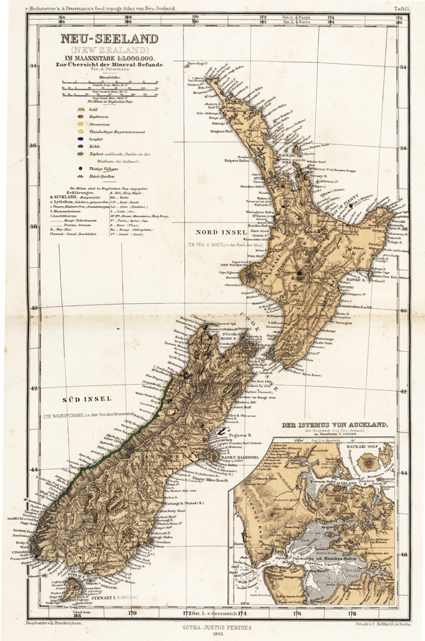
NEW ZEALAND.
BY A. PETERMANN.
Scale, 1: 5,000,000.
1. Gold.
2. Copper.
3. Chrome-iron.
4. Titanic Magnetic Iron-Sand.
5. Graphite.
6. Coal.
7. Nephrite.
8. Active Volcanoes.
9. Hot Springs.
[Image of page 2]
[Image of page 3]
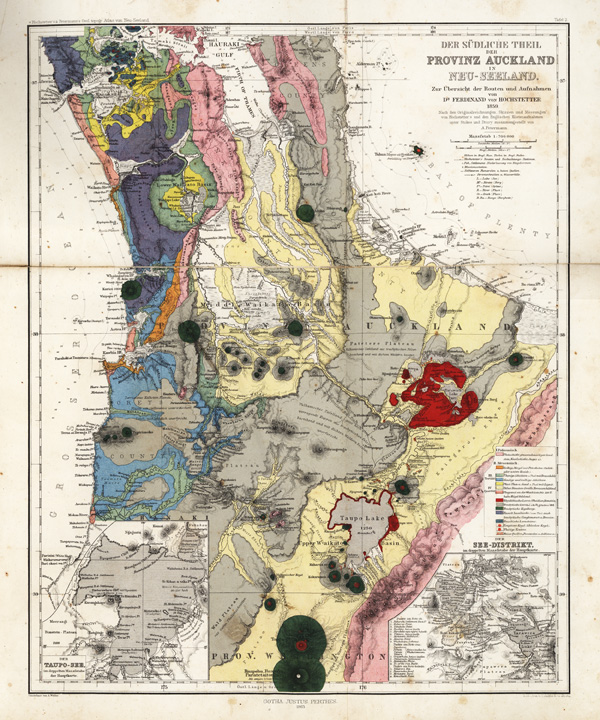
THE SOUTHERN PART OF THE PROVINCE OF AUCKLAND:
EXPLANATORY OF THE
ROUTES AND SURVEYS OF DR. FERDINAND VON HOCHSTETTER.
COMPILED BY A. PETERMANN, PROM THE ORIGINAL DRAWINGS, SKETCHES, AND MEASUREMENTS OF DR. VON HOCHSTETTER, AND THE ADMIRALTY SURVEYS BY STOKES AND DRURY.
Scale, 1: 700,000.
I. PALEOZOIC
1. (Pink) Clay-Slate, Grauwacke, Silicious and Jasparoid Slate.
II. MEZOZOIC
2. (Orange) Fossiliferous Calcareous Marl (probably Oolitic or Lower Cretaceous. )
III. TERTIARY
3. (Green) Laminated Clays, with. Braun-Coal.
4. (Blue) Arenaceous and Calcareous Shales.
5. (Yellow) Plastic Clay and Sand, with Braun-Coal.
6. (Light Yellow) Diluvial Pumice, forming Terraces.
7. (Light Bed) Sand Dunes on the West Coast forming hills to the height of 500 feet.
8. (Dark Bed) Rhyolitic Lava, Obsidian, and Pumice.
IV. QUATERNARY
9. (Grey) Trachytic Lava Streams passing into Tuffaceous Strata.
10. (Dark Green) Trachytic Cones.
11. (Purple) Basaltic Lava passing into Trachytic Conglomerates and Breccias.
12. (Dark Grey) Basaltic Lava Streams.
13. (Red Point) Extinct Scoria Craters.
14. (Red Circled Point) Active Craters.
15. (Red Dots) Hot Springs, Fumaroles, and Solfataras.
[Image of page 4]
[Image of page 5]
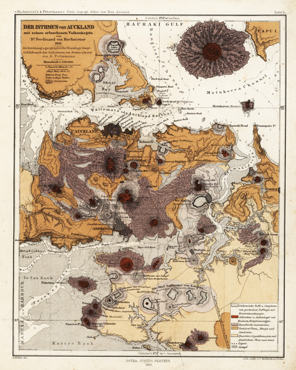
THE ISTHMUS OF AUCKLAND, WITH ITS EXTINCT VOLCANOES
BY DR. FERDINAND VON HOCHSTETTER:
THE DRAWING AND GEOGRAPHICAL FOUNDATION IS COMPILED PRINCIPALLY FROM THE SURVEYS BY STOKES AND DRURY.
BY A. PETERMANN.
Scale, 1: 120,000.
1. (Light Grey) Stratified Volcanic Tuff and Breccias, with numerous Craters.
2. (Brown) Scoria and Ash Cones marking Craters or Centres of Eruption.
3. (Dark Grey) Basaltic Lava Streams.
4. (Buff) Tertiary Clay, Marl, and Sandstone.
5. (Light Buff) Quaternary Lignite Formation, with Plastic Clays and Sandstone.
6. Lignite.
7. Swamp.
[Image of page 6]
[Image of page 7]
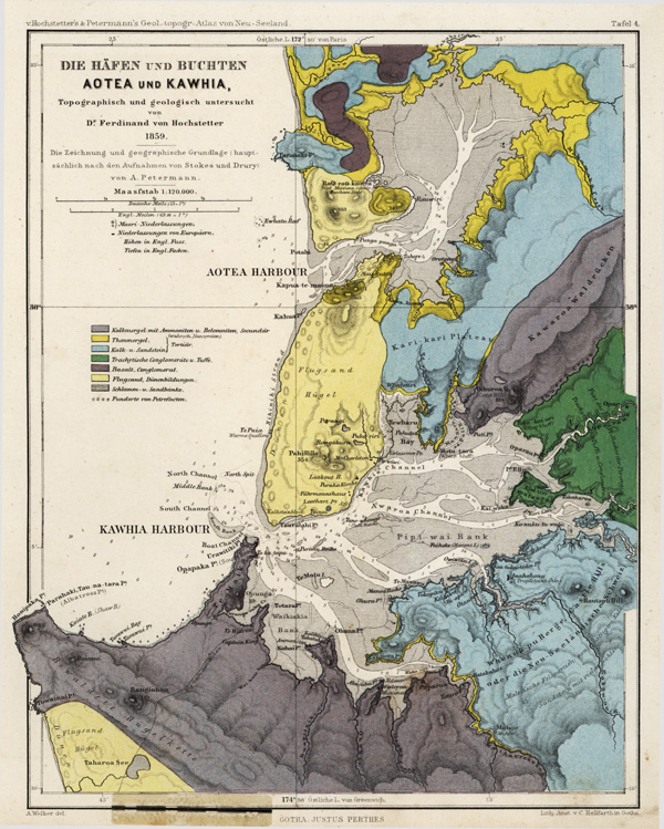
THE HARBOURS AND BAYS OF AOTEA AND KAWHIA.
TOPOGRAPHICALLY AND GEOLOGICALLY EXPLORED BY DR. FERDINAND VON HOCHSTETTER.
THE DRAWINGS AND GEOGRAPHICAL GROUNDWORK IS COMPILED FROM THE SURVEYS BY STOKES AND DRURY BY A. PETERMANN.
Scale, 1: 120,000.
1. (Grey) Calcareous Marl, with Belemnites and Ammonites, Secondary and probably Neocomean.
2. (Yellow) Clay Marl.
3. (Blue) Limestone and Sandstone.
4. (Green) Trachytic Conglomerate and Tuff.
5. (Purple) Basaltic Conglomerate.
6. (Yellow) Sand Hillocks.
7. (Faint Lines) Swamps and Flats.
8. Localities for Fossils.
[Image of page 8]
[Image of page 9]
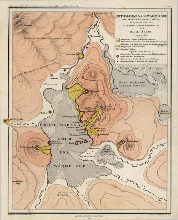
ROTO-MAHANA, AND THE HOT SPRINGS:
BY DR. FERDINAND VON HOCHSTETTER.
Scale, 1: 12,000.
1. (Light Pink) Trachytic Bock of Rhyolitic Type.
2. (Pink) Localities where the Ground is hot, the Rocks being decomposed into many-coloured Clays, emitting innumerable Jets of Steam.
3. (Yellow) Silicious Sinters.
4. Swampy Flats--Ngawhas and Puias--Hot Springs, Fumaroles, Solfataras, and Mud Volcanoes.
5. (Red circle) Large Basins of Boiling Water.
6. (Red dots) Small Hot Springs.
7. do. Mud Volcanoes. Native Huts.
[Image of page 10]
[Image of page 11]
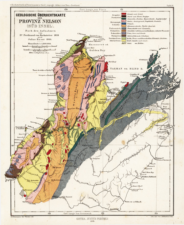
GEOLOGICAL SURVEY MAP OF THE PROVINCE OF NELSON,
(SOUTH ISLAND),
AFTER THE SURVEYS BY DR. FERDINAND VON HOCHSTETTER, 1859, AND JULIUS HAAST, 1860.
Scale, 1: 1,300,000.
I. Eruptive Formation.
1. (Red) Granite and Syenite.
2. (Red and Black lines) Diorite and Diorite Porphyry.
3. (Dark Green) Serpentine, Diabase, Hypersthenite, Augitic Porphyry.
4. (Pink) Gneiss, Gneiss-Granite, Am-])hibolite, and Granulite.
II. METAMORPHIC.
5. (Blue) Limestone.
6. (Orange) Mica-schist, Phyllite, and Quarzite.
III. PALAEOZOIC FORMATION.
7. (Grey) Clayslate and Sandstone
8. (Orange dotted) Sandstone, with Fossils, near Richmond, most probably Triassic.
IV Secondary Formation.
9. (Blue) Triassic, Jurassic, and Cretaceous
10. (Green) Coal strata
TERTIARY FORMATION
11. (Light Green) Lime, Clay, and Braun Coal
DILUVIAL FORM.
12. (Yellow) Drift--(Gravel and Sand).
(Gilt dots) Gold. (Black dots) Coal Seams.
[Image of page 12]