GEOLOGICAL REPORT ON THE LOWER WAIKATO DISTRICT
[Image of page 1]
GEOLOGICAL REPORT
ON THE LOWER WAIKATO DISTRICT,
(WITH MAPS AND SECTIONS,)
BY CAPTAIN F. W. HUTTON, F.G.S.
THE author of the following Report on the Geology of the Lower Waikato District, (Captain Hutton, F.G.S.,) though not on the staff of the Geological Department, was appointed to make the survey by His Honor the Superintendent of Auckland, at my suggestion; and as a means of preserving and circulating the very interesting and useful details he has obtained respecting the structure of the district he examined, it has been considered desirable that his communication should be printed along with the reports of the department.
JAMES HECTOR.
Geological Survey Office, Wellington,
3rd June, 1867.
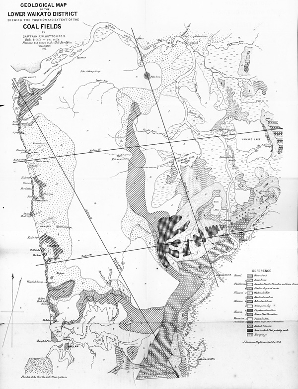
BEFORE commencing my Report I think it but right to state how far the accuracy of the accompanying map and sections may be relied on, for it is evident that until a regular trigonometrical survey of the country has been made, and a map prepared showing all the mountains, streams, and other physical features, it will be impossible to make a geological map that shall show correctly the position of the lines of outcrop of the various rocks.
The map furnished to me by the Survey Office was most complete in the country on the right or east bank of the Waikato, and along the West Coast, and here, therefore, my map may be looked upon as tolerably correct. Next in point of accuracy comes the position and extent of the coal fields, for as this was of the greatest importance, I spared no pains in taking the bearings of the principal mountains, &c. to lay down this part as exactly as possible, but as the position of the mountains were not shown on my map, and the bearings were only taken with a prismatic compass, strict accuracy must not be expected.
To obtain correctly the extent of the coal fields, would require a regular survey which would take a month or six weeks at least to complete.
[Image of page 2]
The greater part of the country between the West Coast and the Waipa and Waikato Rivers, is as yet quite unexplored by Europeans, and no survey, further than cutting a line or two across it, has been attempted, therefore, in this portion of my map the lines must be taken as indicating only the probable general direction of the boundaries of the various strata, and not by any means as their exact line of outcrop.
It is also just possible that the brown coal formation may be intermediate in age to the Whaingaroa clay and the Aotea sandstone, in which case the coal fields would be much more extensive, and might be found north of the Wangape Lake. I could, however, obtain no evidence of this, and I incline much more to the opinion that they are as I have here placed them, anterior to the Whaingaroa clay.
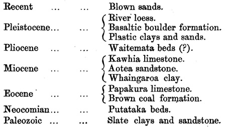
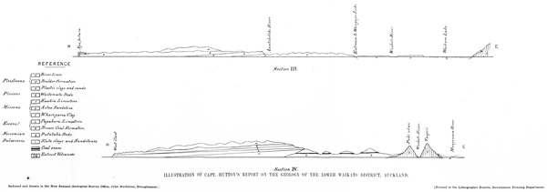
The following table shows the relative order of the different rocks found in this district:--
A chain of mountains composed of primary slates and sandstones, rising to 900 feet in the southern part, but with several breaks in the northern, forms the eastern boundary of the district. This strip, not much more than two miles wide in the broadest part, is the only place where these rocks are found, and consequently the only place where there is any chance of finding gold in situ.
As far as my observations went I saw no signs of quartz veins, and I cannot, therefore, think it probable that they contain gold. Their extent is much too small, even supposing they contained gold, to afford sufficient materials for a payable alluvial gold field of any extent, and I have not, therefore, the slightest expectation that one will be found here. As I wish to be clearly understood on this very important point, I will repeat that I think it possible, but not probable, that auriferous quartz veins will be found in the range running from behind Waikare Lake, through Puke-more, Rangiuru,
[Page 3 is blank]
[Image of page 4]
it does not fall to pieces easily. Both the streak and powder are black and glistening.
It is easily ignited, and burns with a bright clear flame, throwing out an intense heat, and falling into a light grey ash, easily blown away, and without any appearance of caking.
It is burnt with much satisfaction on board all the steamers plying on the Waikato, and I would recommend that samples be sent to the laboratory of the New Zealand Geological Survey at Wellington for analysis, as I am of opinion that it will be found equal, if not superior, to any of the hydrous coals of New Zealand:
On the east bank of the river the coal is again seen. No complete section has been made of it here, but it appears to be 8 or 10 feet thick, but accompanied with a good deal of shale.
Further eastward the coal field is continued in small detached blocks, each occupying the centre of a spur running from the higher slate ridge, all the coal between these detached portions having been washed away by denudation.
South-west of the present mine the coal field expands into much larger dimension, although here, too, it is divided into several detached blocks, each, as a general rule, getting larger as you recede from the river, until it is cut off and overlaid by the Whaingaroa clay and Aotea sandstone.
Near the head of the Awaroa River I obtained a pretty fair section of the coal seam, and considered it to be 12 or 15 feet thick. It is, therefore, probable that it obtains an average thickness of at least 12 feet throughout this district.
It is of course impossible as yet to estimate, even approximately, the area over which the coal extends; but as some idea, however rough, may be thought desirable, I may say that, in my opinion, the area of the coal fields on the eastern side of the river is about 300 acres, and that they contain about 2,800,000 tons of coal; and that the coal fields on the western side of the river cover an area of 7360 acres, and contain about 137 millions of tons of coal. 1 The whole of this can be got without pumping, or any mechanical means for raising the coal to the surface.
The largest mass of coal in a continuous block appears to be south-west of the source of the Awaroa River, and I would suggest to any company proposing to work this part of the field that the best way would probably be to make a tramway down the valley of the
[Image of page 5]
Mangaohei River, and so deliver the coal on the Waipa, opposite to Ngaruawahia.
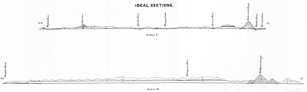
The seam at the present coal mines, and on the opposite side of the Waikato, is 150 feet above the river, or about 220 feet above the sea-level. At the source of the Awaroa River it is about 50 feet higher. Whether it rises gradually from the river to this level, or whether it is thrown up by one or more faults, I cannot say, but think that the latter is probably the case, as a fault is seen in the present working running in a nearly east and west (true) direction, with a trend of 50 deg. north, and throwing up the south portion about 7 feet.
The clays of this formation, being derived from the decay of the slate rocks on which they rest, are exceedingly like the recently decomposed primary rocks, and, as they contain no fossils, it is often very difficult, in places, indeed, almost impossible, to distinguish between the two, the ironstone nodules being the chief characteristic of the coal formation.
On the east slope of Kapamahanga Range a series of banded light yellow and red sandy clays occurs, about 400 feet in thickness. From their position I presume that these are of the same age as the brown coal formation, but they differ very much in appearance from it, and I observed no sign of coal. Dr. Hochstetter, however, says that he was informed that coal had been found in the neighbourhood.
It appears probable that the limestone which is seen resting on the secondary rocks, south of the Waikato Heads, and the one in the Kapamahunga Range, are extensions of the same bed that is found at Papakura, and I have therefore taken Dr. Hochstetter's name for them.
South of Waikato Heads it is about six feet thick, and near the base very impure, often passing into a conglomerate; but towards the upper parts it is better, and might perhaps be used for pavement, or even some portions for chimney-pieces, &c. It is divided into slabs, varying from an inch to a foot or more in thickness.
At Otehe Point it has similar characters, but at Te Kapamahunga, on the east side of the primary mountains, opposite to Tuikaramea, it occurs as a subcrystalline or compact rock, of a pale reddish-yellow colour, and would form a most excellent building stone. A specimen of the rock from this locality is forwarded with this report. I was not able to ascertain its thickness here, but judge that it will not be found in less than 30 or 40 feet.
[Image of page 6]
The bed is a yellow sandy clay at Whaingaroa Harbour, passing soon towards the north-east, into a light blue indurated marl. Its thickness, north of Wangape Lake, is not less than 150 feet.
It generally forms undulating fern covered hills, and, as it contains a sufficient quantity of lime, will probably form a good soil for grain crops.
Pale-blue calcareous sandstone, getting coarser grained towards the north. This sandstone can be traced almost continuously from Waikato Heads to Aotea Harbour, and it contains the same fossils at both places; it covers, however, comparatively little ground on the surface. Behind Wangape Lake, and down towards Hakarimata Range, it forms a highly picturesque country, abounding in steep precipices thickly covered with bush. The soil into which it decomposes is very good, but the broken character of the country which it forms will always be against the agriculturist.
It varies in thickness from fifty to two hundred feet.
At Te Kara Point on the West Coast, this limestone is seen to rest immediately upon the Aotea sandstone, and it here attains a thickness of 100 to 120 feet; but it thins out rapidly to the North, and does not appear again in this direction. Further south beyond Kawhia, it attains, according to Dr. Hochstetter, a thickness of 400 feet, and I have therefore taken its name from this district.
It is a very hard crystalline tabular limestone, splitting into thick flags, and in many places composed almost entirely of rolled fragments of shells and corals, and sometimes containing rounded pebbles of quartz.
Above the Kawhia limestone comes a series of soft reddish sandstones, alternating with thin beds of bluish clay; this series attains a thickness of 300 feet or more, and I could detect no fossils in it. There is no direct evidence to prove the synchronism of this series with the Waitemata beds, but as they are not likely to be very distant in age, I prefer for the present to group them together.
They are extensively developed all along the West Coast, and at the Bluff, Mercer, and Queen's Redoubt. They form a poor but dry soil, more adapted for a sheep run than for arable farming.
[Image of page 7]
These sands and clays being only local deposits, vary, of course, very much in different localities.
At Wangape Lake the following section is exposed, which is a fair example of these rocks north of Taupiri:--
(a). Yellow clay with pebbles of limestone ... 5 feet.
(b). Red, yellow, and white banded clays ... 12 "
(c). Chocolate coloured loam full of fossil ferns and phoenogainic plants ......... 2 "
(d). Finely laminated blue clay with vegetable remains ............... 8 "
These clays form but a poor soil.
North of Taupiri the clays contain much pumice and other volcanic rocks, and are here highly fertile.
In the Waitetuna Valley, near Raglan, they consist of clays interstratified with sands, and gravel beds of pebbles of sandstone. Here also they appear to be very barren.
The greater part of the centre of the country between the West Coast and the Waikato is covered with a rich red loam containing large boulders of basaltic rocks, and occasional blocks of sandstone. This country has been but little explored, and its drainage is not yet fully understood. It consists of steep hills rising to an average height of 700 feet, for the most part thickly covered with bush, among which the kauri is far from uncommon, and grows to a considerable size, though not, perhaps, equalling on an average those of the North. This tree (the kauri) extends all down the Taupiri and Hakarimata Ranges, and I saw some at Kapamahanga, the point furthest south to which I went. I mention this as it is generally thought by botanists in England, if not by the settlers here, that with the exception of a few stunted trees at Kawhia, the kauri is not found south of a line drawn from Manukau Heads to Mercury Bay.
In the Waitetuna Valley this boulder formation is seen to overlie the plastic clays. It forms a country which, though hilly, is of a most fertile character, equalling perhaps any in the Province.
On either bank of the Waipa and Waikato, extensive level plains are often seen formed of a fine rich loam, resting on pumice, sand, and gravel, the latter being often cemented into bands with peroxide of iron. This "loess," as it is called, always presents a level surface
[Image of page 8]
although, often rising to some height above the river. It is light, easily worked, and very fertile, growing most luxuriant crops of red and white clover, but is perhaps better adapted for grazing and root crops than for corn. Great parts of it are, however, at present covered by extensive swamps, but which, situated as they are, close to a river with so rapid a fall as the Waikato, can present no very great difficulties to their effectual drainage.
I cannot close my Report without bearing my testimony to the great accuracy of Dr. Hochstetter's geological map of this district, the general correctness of which, considering his short visit to the country and the ignorance that then prevailed with regard to its physical geography, excites my wonder and admiration, and it will be seen that I have seldom been compelled to differ with him, except as to the tertiary rocks.
F. W. Hutton.
[Inserted unpaginated illustration]
[Inserted unpaginated illustration]
[Inserted unpaginated illustration]