[Text]
[Image of page 3]
NOTES.
Of a short Tour into the interior of the NORTHERN COLONY of NEW ZEALAND, in March and April, 1852.
HAVING engaged five Maories to accompany us and carry our luggage, consisting of a tent, carpet bag, some cooking utensils, and a small supply of stores, as provisions for our journey, on the 26th of March the natives slung their pekaus on their shoulders, and set out for the Waikato.
On the following day, I left Auckland at two, P.M., and, after a pleasant ride of four hours, arrived at Mr. Cole's Inn, Papakura, at sunset. Along the whole line of road from Auckland to Papakura, about twenty miles, the country is nearly filled up, and in some parts thickly populated, especially the district between Auckland and the River Tamaki, which is worthy of a particular description.
From Auckland to Remuera, from Remuera to St. John's College, from St. John's College to the Tamaki, Panmure, and Otahuhu, the whole country is subdivided and enclosed, and brought into the highest state of cultivation. Houses and homesteads, indicative not only of comfort but of wealth, appear one after another in rapid succession. Here are to be seen Farms, varying in size from one hundred to one thousand acres, in the highest state of cultivation; and innumerable fields of the finest pastures, containing fifty, one hundred, and many of them two hundred acres, all fenced--some with substantial stone walls, and others, with hawthorn hedges--meet the eye in every direction. At the same time, situated by the way-sides, in the green lanes, and amidst the quiet copses, appear numberless cottages, with their fruit gardens and slips of cultivation and pasture land, intersected with numerous hedge-rows, all characteristic of rural life, tastes, and occupations.
[Image of page 4]
A great part of the country around Auckland is level or slightly undulating, with less wood than might be expected, and would be monotonous were it not for its cultivation and the existence of a number of volcanic hills of considerable height, isolated, and rising abruptly from the plain. These hills are to be seen, all over the district, situated at a considerable distance from each other: some are clothed with wood on the sides and round the base, others, surrounded with large blocks of scoria, or broken into confused masses, and all of them covered with wild shrubs and luxuriant indigenous vegetation, --which, contrasted with the graces of culture, display fresh beauty, and embellish the landscape with more engaging charms.
And not less attractive in appearance are the different villages and hamlets of Remuera, Epsom, St. John's College, Panmure, and Otahuhu, which lie scattered over the face of the country, like the bright tints in a painting, imparting life and animation to the scene; while beyond the blue and placid waters of the Waitemata, on the opposite shores of the Auckland Harbour, in their varied character of grandeur and beauty, appear the different Islands of Rangitoto, Motutapu, and Waiheki, forming half a circle, and enclosing the estuary from the sea. Beyond these again, in the distance, and bounded by the horizon, is to be seen the dim outline of the mountain ranges near Cape Colville, 3000 feet high, on the opposite side of the Frith of the Thames; which, under the brightness of a summer's sun and a cloudless sky, fill up and complete the features of a landscape, conspicuous for its captivating loveliness and surpassing beauty.
And this scene becomes still more interesting when it is recollected that, in some measure, it is associated with the memory and rendered classic by the genius of Cook, as some of the prominent features of the country so faithfully delineated by the great navigator, are to be seen from the windows and verandahs of the houses in the Town of Auckland. And, upwards of seventy years before New Zealand became a British colony, Captain Cook, in his interesting narrative of the country, made the following observations in reference to the site of its future capital:--
"If the settling of New Zealand should ever be deemed an object deserving the attention of Great Britain, the best place for establishing a Colony would be the Frith of the Thames, where settle-
[Image of page 5]
ments might be extended, and a communication established with the inland parts of the country." And Captain Hobson, the first Governor of New Zealand, an able and experienced officer who had previously acquired, in the course of service, a perfect knowledge of the country, directed his attention to the same quarter, and fixed the site of the capital on the shores of the Waitemata, an estuary in the Frith of the Thames. A severe attack of apoplexy, with which Governor Hobson was seized, prevented him, however, from carrying his design into immediate operation, although preparatory measures were in progress for the settlement of the capital; but it was not until the 1st of February, 1842, only ten years since, that the first sale of country lands took place at Auckland. Governor Hobson's selection of a site for the Seat of Government was soon after confirmed by Lord Stanley, and Auckland, by Royal proclamation, became the capital of New Zealand.
After crossing the Tamaki by the new bridge, a short distance beyond the Village of Otahuhu, and about nine miles from Auckland the road for four or five miles runs through a very fine district, chiefly of an undulating character, although in some places extremely level. This district extends from Pukake Creek, on the Manukau, to the Town of Howick--about twelve miles in length, and from three to six miles broad. On the east it is bounded by a low range of wooded hills, remarkable for their beauty; and on the west by the River Tamaki, which almost intersects the Island, and is navigable as high as the bridge, from which place to Auckland a steamer runs daily. The greatest part of this district was only brought into notice about two years since, but it now contains numerous farms, many of them extensive and well cultivated: some of the houses and homesteads are of a superior description, and, from their situation, extremely beautiful. This part of the country presents many attractions, being beautifully wooded, intersected with numerous streams, and possessing a soil of the greatest fertility.
On arriving at the foot of the ridge, we were shown the new line of road, which runs to the right of the present one, and takes a course round the base instead of ascending the hill, which is a great improvement to the old line.
[Image of page 6]
The old road over the ridge is easily travelled on horseback, but not well adapted either for a carriage or dray. Near to the top we passed one or two cottages, and observed some patches of cultivation. A short distance to the right the Surveyor-General's farm is to be seen, --the homestead looks pretty enough, but the land in its vicinity does not appear to be of the best description.
After passing through the woody belt immediately behind Mr Hunter's cottage, we arrived at an open country; and a few hundred yards further brought us to the brow of the hill, in view of the Papakura Plain, and beyond it the chain of wooded hills near to the source of the Wairo River. This chain of hills extends, in a southern direction, from the Wairo to the Waikato, and is the eastern barrier of the Auckland district, beyond which no one has ever penetrated--and the country immediately adjoining it still remains a terra incognita. 1
The district of Papakura is beautiful, and in appearance resembles the country in the neighbourhood of Windsor, New South Wales. Mr. Cole's house is pleasantly situated near to the old Pah of Papakura, at the termination of a level plain containing upwards of seven thousand acres. The Papakura River runs through this plain, which renders it very valuable, affording as it does at all times, not only an abundant supply of fresh water, but is well adapted for machinery, and Mr. Cole intends erecting a mill near to where the river falls into one of the creeks of the Manukau, which will be of great importance to the district. This is characteristic of the Anglo-Saxon family;. for it is said wherever they go they erect a mill, a Church, and a brewery. Mr. Cole has done well to erect a mill, as I have no doubt the Church and brewery will soon follow, and the Village of Papakura promises to be one of the loveliest that ever adorned a landscape.
We left Mr. Cole's on the morning of the 28th and took the road for Tuakua.
On leaving the Papakura Plain, we soon arrived at a fine undulating country, where the soil is of the richest quality, and the
[Image of page 7]
landscape of unusual beauty, from the numerous clumps of wood still remaining, giving it the appearance of an Englih park. This spot was purchased from the natives by a Mr. Chisholm and some others, under the authority of Governor FitzRoy's land-purchase proclamation, and is still known by the name of Chisholm's Bush. But the purchase was disallowed by Governor Grey, and the land seized by the Surveyor-General. As Chisholm, however, did not complete his purchase, the native title remained still in force; and the land could not therefore, by any possibility, revert to the Crown. In the first instance, the natives strongly remonstrated with the Governor on the injustice of such a proceeding, without obtaining redress; but when the Surveyor-General attempted to survey the land, they very naturally became exasperated, and drove off the surveying party, resumed possession, and still retain it, although the Government have resorted to every expedient to recover it, except the proper one of paying for it. There is, however, little doubt but the Government will purchase this block, as the natives have offered to sell it on extremely moderate terms-about sixpence per acre. 2
Half an hour's ride further on brought us down to the pass of Slippery Creek, which is the extreme point of one of the numerous creeks of the Manukau. On the present line of road Slippery Creek is rather an ugly looking place, and from the slippery nature of the rocks, perforated with innumerable holes of some depth (very convenient for a horse to put his foot in) some caution is necessary in crossing it on horseback, but as the new line of road runs higher up and leaves the creek, this awkward spot will therefore be avoided. The tide rises to a considerable height in the creek, and as two small streams fall into it at one point near the present crossing place, it looks somewhat formidable during flood tide, especially if there is a heavy fresh in the rivers. We crossed at low water, but many people take it at the flood, and swim their horses.
Our ride from Mr. Cole's to Slippery Creek was delightful: the morning was pleasant, the road good, and the country of such beauty and fertility, as would have pleased the eye of an artist as well as an agriculturist.
[Image of page 8]
About a quarter of a mile beyond the creek, Mr. Runciman, who has a cattle station at this place, has built a cottage, and, although a sexagenarian, has shown great enterprise, being the first person who ever crossed the Papakura River and Slippery Creek with a loaded dray. According to the Depasturing Regulations, Mr. Runciman is entitled to select and purchase eighty acres as a homestead, at the upset price of one pound per acre--and here he has made his selection and taken up his residence. The site of his cottage is good, and the selection exhibits both taste and judgment, having on his left a tidal creek connected with the Manukau; on his right, a considerable stream of fresh water; and in the background, a wood, which is both useful and ornamental. May success attend his undertakings, ashe justly merits a reward for his enterprise, being the first settler who has taken up his permanent residence beyond the Slippery Creek.
From Slippery Creek to the Native Settlement of Tuamata the country is open and easily travelled on horseback. On the west, in the direction of Waihuku, the country at one time must have been heavily timbered, as the remains of forest trees are still to be seen. Immediately on the east appear the chain of hills which intersect this part of the country, with their sloping sides sweeping down to the plain, beautifully wooded, and resembling in appearance some parts of Derbyshire. At some distance we observed the smoke of a Native Village curling above the trees, but the habitation of civilized man was nowhere to be seen. The Native Pah of Tuamatu is a wretched-looking place, with very few inhabitants, and the situation no way remarkable, except its convenience for wood and water, which is a sine qua non in a Maori Kianga. We halted here for a couple of hours, in order to give our Maories some rest after the morning's march. The old chief was very hospitable, and presented us with potatoes, water-melons, and Indian corn; and we dined by the side of the creek, under the shade of a large tree, which afforded convenient shelter from the rays of a noonday sun.
On resuming our journey we immediately entered a wood, through which the line of road runs, with the exception of one or two openings for upwards of ten miles. The present track or pathway through the bush is both narrow and crooked, and although easily travelled on foot, is not well adapted for horseback, for, in addition to the trouble of keeping your horse as well as rider clear of trees and
[Image of page 9]
brushwood, numerous ravines and streams have to be crossed, which renders this mode of travelling tedious and unpleasant. Without much difficulty, we, however, made our way by swamp, stream, and woodland, and reached the open country before sunset, when we pulled up for a short time to allow our natives who had fallen behind to overtake us. The natives soon made their appearance, but sat down and refused to proceed further, being, as they said, quite fatigued with their long march and heavy pekaus, and strongly urged the necessity of encamping for the night where we stood. The poor fellows had some good ground for complaining, but we were anxious to proceed, and if possible to reach the Waikato before nightfall, which was only four miles distant. We therefore gave each of them half a glass of brandy, and at last persuaded them to move, and after an hour's ride through a fine and open part of the country, intersected with numerous streams, we arrived at the Native Settlement of Tuakau a little after sunset. Our natives were not far behind, and as soon as they arrived they unslung their pekaus and made immediate preparations for our encampment. While one party was pitching our tent and making up our beds of fern, another was lighting a fire and preparing the tea kettle, and within a little more than half-an-hour we were comfortably seated round a blazing wood fire, enjoying a pannikin of warm tea and smoking cigars. As usual, the Maories of the village came out to see the strangers, and we had a numerous party of men, women, and children assembled round our fire, who continued smoking and talking long after we went to bed.
We got up at daybreak on the morning of the 29th, and, while the Maories were preparing breakfast, I strolled about the Settlement and the adjoining fields. The Maori Kianga of Tuakau is of the poorest description, and, with the exception of its small enclosures of cultivated ground, is not superior to the temporary encampment of a tribe of wandering gypsies, so frequently to be seen in some of the remote districts of England and Scotland. Its population is not numerous, and the few natives that we saw appeared to be of an inferior class. The country, however, is very fine, consisting of open fern glades, with patches of wood.
There was a thick fog hanging over the bed of the Waikato, which concealed it for some time from view: as the morning advanced, however, it cleared off, and I got a sight of the river through an opening
[Image of page 10]
in the wood, about half a mile distant. At this spot, at least on the Tuakua side of the river, the country still retains its level or undulating English landscape character, and which is the descriptive feature in its appearance from Auckland to the Waikato -- about forty-five miles--with this exception, that the greatest part of it is covered with fern, and still in a state of nature. But a short distance below Tuakau the features of the country are changed, and present a very different appearance: the basin of the Waikato expands into a valley of considerable extent; the undulations swell into hills, exhibiting a bold and rugged outline, and assuming a picturesque appearance, highly characteristic of the Scottish lake or river scenery--which, combined with the magnificent foliage of a New Zealand forest, and the windings of the Waikato River, from three to four hundred yards broad, present one of the finest views of river scenery that it is possible to imagine.
After breakfast, we immediately struck our tent, and moved higher up the River to Rakuwaitiri, and opposite Mr. Marshall's Inn, which is on the south side of the river, and three miles above Tuakau. At this place we again readied the chain of hills we saw in the early part of our journey, which, after ranging regularly across the country from the Wairo River, are terminated by bold cliffs on the northern shore of the Waikato.
We crossed the river at this place, which is about three hundred yards broad, expecting to find a canoe at Mr. Marshall's to take us up the river; but were much disappointed when informed that, through some mistake, it had not been provided, and there was none to be procured. After considerable vexation and delay, we, however, obtained one from a native woman who had just arrived, and engaged it for a fortnight, for which we agreed to pay four dollars, certainly a very moderate charge. Everything was soon prepared for our journey, and the party, consisting of five Maories and two Pakehas, having taken their seats in the canoe, were immediately afloat, and the Maories plying their paddles, we skimmed along on the smooth waters of the broad Waikato.
In fine weather it is pleasant travelling in a canoe, and the natives take great delight in shewing strangers their dexterity in navigating it. The native canoes are scooped out of solid trees, and some of
[Image of page 11]
them are sixty, seventy, and eighty feet in length, and four feet broad; but those of a large size are designated "wakataua," or war canoes, and seldom used except on state occasions. These are capable of carrying from forty to fifty natives, and invariably smeared over with a kind of red ochre, handsomely ornamented with a profusion of sea-fowl feathers hanging gracefully from a small pole fixed in the prow, which is decorated with grotesque figures of men and animals, sometimes three or four feet high. They are all made thick and strong in the bottom, and tapering towards a point at the prow and stem, in order to give as little resistance to the water as possible; and sails, are used when the breeze is favourable as well as paddles in navigating them.
But the navigation of a canoe is an important affair with the natives, in which they exhibit great skill and expertness. One of the party is stationed at the prow to keep a look-out, and another at the stern to steer it, while the others are placed in the middle, or in the most convenient part for using their paddles with effect; and some of the party usually chant a song or chorus, to which they keep stroke with their paddles; sometimes they will move leisurely, merely dipping their paddles in the water, when suddenly they will become excited by chaunting some of their wild songs, and, bending to their paddles, sweep along at great speed in full chorus. It is in such scenes as this that the Maories are seen in their native character, and, I think, to advantage; they also appear to be of the same opinion themselves, as they are frequently making displays of this description, and take great pleasure in accompanying the Pakehas in their tours into the interior of the country; in which respect, as far as my experience extends, I have always found them, whether in the bush or canoe, or by the side of their evening camp fire, to be not only useful allies, but intelligent companions.
Although the mid current of the Waikato below the junction of the Waipa is easily withstood or overcome, and does not run more rapidly than from one to three miles an hour, and only at the latter rate in the bends and windings of the river; the natives, however, in order to avoid its influence, ascend in their canoes along the river banks, and usually keep very near the shore, often so close to it as to admit of their leaping out and in of their canoes without stopping. In this way we ascended the river rapidly and slowly, by turns, as the Maories were in humour; but an average speed of from three to four miles an hour
[Image of page 12]
could easily and without effort be maintained for any length of time: in our journey, we averaged about three miles an hour; at the same time it may be observed that the river, at this season, was considered rather low, but its ordinary bed was completely covered, and there appeared no indications of its being greatly below its average level. In our progress, at the bends and turnings of the river, we occasionally met with shallows and sandbanks which retarded us a little, as in such places the channel of the [word xxed out] shifts from side to side, and the Maories had sometimes, although not often, to leap into the water and explore for a little, in order to find it out; but, if the river was surveyed and properly marked off, I think a channel three feet deep would be found for at least one hundred and thirty miles, as large canoes, heavily loaded with the produce of the country, carrying four tons and drawing three feet water, are frequently navigated with the [words xxed out] current upwards of that distance, in all seasons; and I therefore think that a steamer drawing from two to three feet might easily navigate the Waikato in all periods of the year. The river is comparatively clear of snags or sunken trees, and the few impediments to navigation existing of this description are unimportant, and could be easily removed; but in no instance did we ever encounter or even observe floating trees or any obstacles in the character of drift wood. There is likewise no danger to be apprehended from vessels grounding, as the bed of the river consists of clay, sand, and loose gravel, and neither rocks nor stones are to be seen below the junction of the Waipa. Above the Waipa it is called the Horatu, and here the current is stronger and rapid, but at the same time this part of the river is much deeper, besides being wholly clear of shoals and sandbanks, and for fifty miles above the junction there does not exist the slightest obstruction to its navigation. The breadth of the river averaging from two to three hundred and extending in some of the reaches to four hundred yards, surprises a stranger, and this feature in its character is preserved throughout a great part of its course-being nearly two [100 written on top] hundred yards broad and very deep immediately above the junction of the Waipa, which is from eighty to ninety miles distant from the sea, by the course of the river; and this circumstance appears more remarkable when it is considered that the influence of the tide does not reach higher than thirty miles from its mouth. The great length of the Waikato, with its lakes and numerous tributary streams, must drain a considerable extent of country, which would in some measure account for its size; by
[Image of page 13]
the Taupo lake, situated near the centre of the island, and, in extent, almost an inland sea, being upwards of twenty-five miles long and from ten to fifteen broad, is the chief source and main spring of the Waikato, which, after flowing upwards of two hundred miles through one of the finest portions of the island, intersecting in its course the extensive and fertile plains of the Waipa, and rendering available the inexhaustible coal fields which for miles line its margin, 3 falls into the sea on the West Coast, about thirty miles south of the Manukau.
The natives, however, with their usual love for the marvellous, narrate that Lake Taupo is not the source of the Waikato, which is to be found, they allege, about ten miles to the south of it, near Tongoriro, a mountain twelve thousand feet high, having its lofty summit perpetually covered with snow, and describe the stream, which flows from near the base of this mountain into Taupo to be its source; and that its course, different in temperature and colour, can easily be traced through the waters of the lake into the channel of the Waikato on the opposite side. But this story requires confirmation: besides, it is rather improbable that an inconsiderable stream of some thirty or forty yards broad should force a passage, in a compact body, through a lake upwards of twenty miles long, by ten to fifteen broad, and in some places thirty fathoms deep. It is, however, not improbable that the melting of the snows on a mountain such as Tongoriro, which, besides its great height, is always smoking, and sometimes sending forth flames, may constantly feed or occasionally swell the lake, and raise the waters above its level, thereby causing it to flow with greater rapidity into the channel of the Waikato, which is nearly forty yards broad.
In the vicinity of Taupo the ground is covered with pumice stone, and quantities of it, apparently in a decomposed state, globular shaped, and about the size of billiard balls, are to be seen floating down in almost every part of the river; and, after a heavy flood, the sea shore for some miles near its mouth appears strewed
[Image of page 14]
with decomposed pumice stone. With the exception of the eel and two or three small specimens of the crustaceous genus, peculiar to Taupo and some of the other lakes, the Waikato may be said to be destitute of fish, and this peculiarity is alleged to exist from the waters of the Taupo lake being impregnated with sulphur, and hostile to piscatory life.
A short distance above Mr. Marshall's Inn there is a bend in the course of the river, which runs for a little way in a north-east direction, after which its general course is south-east. The banks are in most places high and wooded; and there are several low islands in this part of the river, one of which is of some size, and covered with trees. On the shores of the river we observed many of the forest trees peculiar to the country, and conspicuous amongst the number appear the tall and graceful Kahikatea pine (Dacrydium Excelsum), the Rimu pine (Dacrydium Capressinum), which grows to a considerable size, and is used by the natives of the Waikato for making their canoes; likewise the Totara (Taxus), the most durable of all the New Zealand pines; and the Rata (Metrosidorus Robusta), at first only a climber, but ultimately becoming a large tree; and almost every other except the Kauri, the monarch of the New Zealand forest, which is not to be found in the immediate vicinity of any part of the Waikato.
After paddling up the river for two hours, we desired the natives to look out for a convenient spot to encamp for dinner, and they were not long in finding one. On such occasions, the canoe is in the first place secured to the river bank, and the natives, stepping on shore, make immediate preparations for their fire by collecting fuel, which is soon lighted, and then begin the culinary operations. The bill of fare usually consists of potatoes, sometimes kumeras, and wild duck, all of which, except the kumera, are to be obtained in great abundance, and may be called the indigenous fare of the Waikato; besides which, the Pakehas take care to furnish a supply of foreign luxuries, in the shape of preserved meats and other good things-- and tins of soup and salmon are at hand to vary the course, which is, however, seldom required. When the cooking is completed, the Maories set to work in native fashion; but the Pakehas are careful to provide for themselves knives and forks, and each of them is likewise furnished with two tin pannikins, one being used as a plate and the other
[Image of page 15]
as a drinking-cup. In fine weather, a dinner-party on the hanks of the river is, on the whole, a very pleasant affair, and relieves, to a certain extent, an excursion of this kind from its somewhat monotonous character.
We were soon after in our canoe, and proceeded at our usual rate up the river, without for sometime observing much change in its appearance; but, about ten or twelve miles above Rakuwaitiri, the banks of the river are comparatively low, with less wood, the hills recede to some distance, and country opens out and expands as the river is ascended. Before we got this length it was sundown, and soon after we encamped for the night, on the banks of the river, in an opening of the wood. Our night encampments were generally made in places affording shelter and fuel, and, after pitching our tent and concluding the labours of the day, we often sat talking and joking with the natives for a short time round their evening fire. We always went early to bed--the Pakehas to their tent, and the Maories lying round the fire or under a tree, wrapped up in their blankets.
Soon after sunrise, on the morning of the 30th, we were moving up the river; and, in passing a canoe moored to the river bank, we observed a number of native women assembled round a fire on shore, who, like ourselves, appeared to have been encamped for the night in their journey up the river. We ascended some four or five miles before nine o'clock, and breakfasted on a pleasant spot, adjoining some native huts, where a few Maories appeared to have taken up their temporary residence, and who presented us with a quantity of fruit of the kohutuhutu, which is edible, and in taste and flavour resembles the juniper; the flowers of this tree are different in colour, being purple and green.
The river is very fine for some distance above this place, being broad and deep, with low banks, which are open, with patches of wood. At a place called by the natives the "Pukatea," we observed a canoe, full of people, sweeping down the river towards us; and our natives, with their usual sharp-sightedness, immediately announced them to be Pakehas; and, on its nearer approach, we discovered it to be Brigade-Major Greenwood and Lieutenant Gladwin Wynyard, 58th Regt., with their party of natives, who had travelled overland from Wellington to Wanganui, and by arduous and persevering labour had ascended the Wanganui river, in a canoe, near to its source, and crossing the country
[Image of page 16]
to the west of the Taupo lake, had reached the Waipa, and, embarking in a canoe, came down that river into the Waikato; and, after five weeks travelling from Wellington, had arrived here on their journey to Auckland. It appears that the current of the Wanganui river is strong and rapid, which render its navigation tedious and laborious; and, in ascending it, the canoes are propelled with setting poles, and sometimes dragged by towing lines: besides which, strength and manual dexterity are necessary in order to conquer the force of the wayward stream.
Above the "Pukatea" the country is level, and we ascended for many miles without seeing a tree; there are, however, numerous native villages, with their patches of cultivation, to be seen, which in some measure break the monotony and enliven the scene; but though very uninteresting in appearance, there is a great extent of country available, and of the greatest fertility.
Towards the evening, we arrived at one of the long reaches in the river, which is upwards of five hundred yards broad, and resembles a lake. At this place the channel of the river appears to have only been lately extended to its present size, as in some parts numerous stumps of trees are existing, and apparently still remaining where they grew. A short distance to the left there is a large lake, five or six miles long, called Waikiri, which is connected with the Waikato by a small stream, navigable for canoes. The natives assert that there are numbers of fish in this lake: besides the eel (which is everywhere to be found) there is a flat fish like a flounder, and another described as resembling the kawai.
We encamped this evening at a place called Randall's, where a person of that name resided, and whom the natives denominated a "Pakeha Maori." The Pakeha Maori is a specimen of a class which, at one period, were numerous in New Zealand, and in the early days of the Settlement frequently to be found in the district of the Waikato, but now almost extinct. They were usually sailors, probably deserters from whaling ships, or some of them may have found their way to the colony under still more questionable circumstances, and a few perhaps may have been respectable, but had become so accustomed to the native mode of living and idleness of a bush life, that they had lost all relish for any regular occupation, and preferred the pleasures, freedom, and novelty of savage life, to industry and civilization. This
[Image of page 17]
class of persons usually lived under the protection of some chief, in native fashion, having a wahine for a wife, and a troop of half-caste children, who were all brought up as Maories. The Pakeha Maori invariably sunk to the level of the native character, if not below it, and would occasionally join them in a taua or foray upon a neighbouring chief. Before New Zealand became a British colony they were people of great importance and treated as Rangatiras, being employed in negotiating all transactions between the natives and Europeans, and particularly active in obtaining supplies of muskets and other munitions of war, which were at that time in great demand; but since the foundation of the colony the natives have become acquainted with a different class of people, and the Pakeha Maori has gradually sunk in their estimation, and has now not only ceased to be appreciated, but treated with contempt. They are, however, almost extinct--and at the present time there is not more than one specimen of the class remaining in the whole of the Waikato district.
On the following day, at noon, we arrived at Kaitotihe, where there is a Mission Station and Native Pah, and which is about five or six miles below the junction of the Waipa. Kaitotihe is a pretty place, and the mission-house, a comfortable looking building, is pleasantly situated on a level spot at the base of a range of hills, a few hundred yards from the river: the house is fronting the Waikato, and immediately on the opposite side there is a beautiful cone-shaped hill, called Taupiri, of considerable height, and covered from top to bottom with masses of foliage, which is a fine and peculiar looking object, and seen from a great distance. The native pah is situated near to the mission-house, and enclosed and fortified in the usual style, with a considerable extent of cultivated land adjoining it.
We proceeded up the river in the afternoon, which was more pleasant than travelling under the rays of a noonday sun. A short distance above Kaitotihe, the scenery on the right side of the river is of the finest description. There is a chain of hills of considerable height, densely wooded, and highly picturesque, ranging regularly within a few hundred yards of the river for two or three miles, and extending to the junction of the Waipa, which are extremely beautiful, and is the finest specimen of river scenery we had seen on the Waikato.
At the junction of the Waipa, the river is broad and deep; and,
[Image of page 18]
although the current is somewhat rapid, there is not a ripple to be seen, and the surface of the uniting streams appear os smooth as if oil had been poured over the face of the mingling waters. The delta at the junction is the extremity of an extensive block of table land, terminating in a point or cliff, about twenty feet above the level of the river, apparently of a permanent description, and must have stood in its present state for some length of time, as it bears no marks of having been worn away by the action of the two streams. This point commands the rivers and a couple of field-pieces placed on this spot could sweep the stream below, and sink everything that approached it. The natives kept our canoe close to the opposite shore, and ascending a little way above the junction, put about, and shooting downwards across the stream, aided by the current, entered the Waipa, and, waving their paddles in the air bade "good-bye" to the Waikato.
The Waipa, for ten miles above its junction, is thirty or forty yards broad, having perpendicular banks of rich alluvial soil, covered with fern, open, without timber, and rising nearly twenty feet above the level of the river, which resembles a canal, is very deep, smooth, and as still as a mill-dam. We entered the river at sunset, and having little or no current to contend against, swept along at a rapid rate. Shortly after dark, we arrived at a Maori Kainga, and, after making fast our canoe, we climbed up the steep bank, and were hospitably received by the natives, who furnished us with potatoes and fuel for our fire. The next morning we found that our encampment had been made in a large potatoe-field, which the late hour at which we took up our quarters the previous evening prevented us from perceiving. The natives were busily engaged in raising and securing their crop, which was very fine, and we noticed that they adopted the same plan in preserving it during winter as practised in many parts of Scotland. A pit, from ten to twelve feet in length, by three broad and two deep, is made, into which the potatoes are placed, and filled in level with the ground, and a quantity are then heaped up about eighteen inches higher, tapering very narrow at the top, over which a slight roof of wood and reeds is constructed, and, except at one end which has a projecting roof like the eaves of a house, the whole is carefully covered with earth in such a manner as to protect it from the injuries of the weather. The natives cultivate the potatoe extensively, which, besides being their
[Image of page 19]
chief article of food, are sold to the Europeans in large quantities for domestic use as well as exportation.
At this place, and indeed the whole block of which the extensive and alluvial plains of the Waipa is comprised, the soil is of unrivalled fertility; and, in this respect, I have seen nothing to equal it in this part of the world, except the rich alluvial flats on the banks of Hunter's River, in New South Wales, but which are limited in extent compared with the Waipa.
We proceeded up the river after breakfast, which, except its banks being partially wooded, varies little in appearance, being twenty yards broad, and very deep thirty miles from the Waikato. Although its course is very crooked, with innumerable bends and windings in the river, there are, however, neither shoals nor sandbanks; but snags or sunken trees are more numerous than in the Waikato: at the same time, these are not by any means formidable, or incapable of easy removal, and the only obstacle existing to its being at present perfectly available for steam navigation. The native population is not great, although numerous kaingas or hamlets appear on its margin; but there is no Pah of any importance except Whata Whata, which is, however, regularly built and fortified with palisades, situated in a commanding position, and must have been a place of considerable strength in the fighting days of times gone by.
We landed at Whata Whata, and recognised the chief to be an old acquaintance, whom we had formerly known in some of his visits to Auckland, and who received us with Maori hospitality, taking great pleasure in showing us over his court, yard and adjoining fields, besides pointing out on every occasion his plans of contemplated improvements, especially the erection of a flour-mill, which appeared to him to be a very important affair; and he appeared particularly vain of a very handsome whaleboat, carefully protected from the weather by an excellent boat-house, but evidently, from its appearance, kept as much for show as use. We dined and remained a couple of hours at this place, and in the evening ascended the river for a short distance. On the following day, we were early in our canoe, and about noon, reached the homestead of Mr. Cowall, a settler on the river, which is situ-from forty to fifty miles above its junction with the Waikato.
At this place, a great battle was fought between some of the Northern
[Image of page 20]
tribes and the Waikato, of which I could learn only a few particulars. It appears, however, that about the year 1829, Pomare, a great chief at the Bay of Islands, having obtained a large supply of muskets and other munitions of war, and presuming on his superiority in this respect, resolved, with some of his allies, to invade the territory of the Waikatos who were at that time almost unprovided with European arms. This chief, therefore, sailing along the coast from the Bay of Islands, suddenly appeared in the Waitemata with a squadron of canoes, carrying three hundred and forty, and some accounts say upwards of six hundred, fighting men, equipped in European fashion, entered the River Tamaki, and dragging their canoes across the narrow portage where the Village of Otahuhu now stands, into the Manukau, then navigating its shores for nearly forty miles until they reached Waihuku, where they again dragged their canoes across the narrow portage into the Awaroa, which carried them into the Waikato. On the banks of the Awaroa, they surprised and cut off a small party who resided there; and whose unburied bones were still to be seen, a few years ago, on the spot where they were massacred. The chiefs Waitiri, Katipa, and others, ascended the river in their canoes, and proceeded up the Waipa, pursued by Pomare. The Waikatos, however, having received a reinforcement, and although they had not more than twenty muskets took up a position near to where Mr. Cowal's house now stands, when Pomare and his party arrived at this place they disembarked from their canoes, and were attacked with great fury by the Waikatos, who killed forty of them. In the meantime, the reserve of the Waikatos having arrived from the Thames, consisting chiefly of the Ngatepora, who were well armed, and surrounding the enemy, a total rout ensued, and not more than ten of them, it is supposed, escaped--among whom was Te Tinana, now residing at Orakei. In the fight, Pomare behaved with gallantry, and the last shot he fired carried off the arm of a man who held an uplifted spear, intended for his destruction, but immediately afterwards he received a thrust from a spear, which brought him to the ground; while in this position, he endeavoured to rally his people, who were fast giving way before the Waikatos; he was, however, quickly surrounded, and as quickly dispatched by a blow from a tomakawk, immediately above the eye, by one of Katipa's people. His body was cut into small pieces and distributed among his enemies, and his head was long preserved as a trophy of victory, but subsequently restored to his relatives at the Bay of Islands.
[Image of page 21]
Mr. Cowal's house is situated near to what may be termed the head of the navigation of the Waipa, as a steamer could not ascend much higher, although the natives navigate the stream in their canoes for many miles further; but the country above this place is very fine, consisting of extensive and fertile plains, well watered, and, in some parts, available for sheep. On the opposite side of the river, and about four miles to the west of it, there is a lofty ridge of wooded hills, the highest of which is called Perongia, remarkable for its picturesque beauty. This chain of hills ranges along the whole course of the Waipa, bounding the plain in this direction, and presenting on their sloping sides many beautiful sites for homesteads, having a north-east exposure, and completely sheltered from the gales of the West Coast, which, in some places, is not more than twenty miles distant.
The Waipa plains consist of an extensive plateau, or table land, part of which is comprised in a delta formed by two navigable rivers, the Horatu (Waikato) and Waipa, and extending from the junction of the latter to its source, about thirty-five miles by compass, and in breadth averaging about twelve miles between the two rivers, although in some places extending to twenty; but beyond the extremity of the Waipa there is a continuation of the plain stretching out towards the West Coast, and extending for twenty-five miles in the direction of the Mokau river, which, including the delta, cannot be less than sixty miles in length; and from the extremity of the plain at the base of the hills near Mungatautara to the opposite side towards Mokau, it must be thirty miles broad, as the view from Maungatautara is unbroken in this direction, and bounded by the horizon. The plains are known by the general name of the "Waipa," but on the east side of the Horatu river similar plains exist, being a continuation of the same plateau or table land, which extend for many miles, and appears bounded in this direction by the chain of hills ranging near to the River Thames: this is called the Horatu district. These united plains are bounded on the west by the chain of hills ranging regularly about five miles distant from the river along the whole course of the Waipa; on the east by the dividing range near the River Thames; on the north they are contracted below the junction of the Waipa to the breadth of the basin of the Waikato; on the south by the country towards Taupo; and on the south-west extending nearly to the Mokau river, and contain upwards of one million of acres, consisting of volcanic and alluvial land of unrivalled
[Image of page 22]
fertility, available either for pasture or cultivation--being well watered, intersected by two navigable rivers, and only seventy miles distant from Auckland by compass. The Keri Keri Roa, on the banks of the Horatu, appears to be a point from which there is easy access to the whole of this part of the island; and a bridle road, extending from somewhere near Mr. Cole's Inn across the chain of hills which range from the Wairo to the Waikato, running nearly in a direct line to the Keri Roa, could be made without much difficulty, as the distance is not more than fifty miles; and by means of a punt for crossing the Horatu at this place, the whole country would be opened up and rendered available. From the Keri Roa it is only forty miles to Wangaroa, on the West Coast, and over a country which is easily travelled on horseback: from the same place to the Mokau river it is about fifty miles, which is still more accessible, and there is a good road from the Horatu to Mata Mata, on the River Thames; while to Rangahaphia and the Waipa it is only a morning's ride. For forty miles in every direction, from the Keri Roa, the country is open, available, and easily travelled on horseback, except on the north, which is in the direction of Auckland. The description of road required for this purpose need not be expensive--a good bridle path which would permit sheep and cattle to be driven to the plains from the Auckland district would be sufficient, and this could easily be made at the rate of ten pounds per mile. To attempt to make a dray road in this direction at present would be injudicious; besides, it is not required, as the Waipa and Waikato are more available for the transit of colonial produce than any road that could be made in New Zealand for the next fifty years.
We were kindly furnished with horses by Mr. Cowal, who accompanied us in our ride across the country to Rangahaphia, which is about sixteen miles from his place. The delta for some miles towards Otawao is volcanic, level, or slightly undulating, with patches of alluvial land, intersected with numerous streams. In the centre of the plain, near the extremity of the Waipa, there is a large hill called Kokapuku, isolated, and rising abruptly, of considerable elevation, which is a very conspicuous object, and seen from a great distance.
After a pleasant ride of a few hours, we reached Otawao, a native village in the centre of the plain where there is a mission station, when we pulled up for a little. We then proceeded, in the afternoon, to Rangahaphia, which is a few miles further from the Waipa.
[Image of page 23]
The Native Village of Rangahaphia is about two miles long, nearly as broad, and is quite different from an ordinary Maori Kainga. Each house is separate, and has two or three acres or more attached to it, which are enclosed, and completely cultivated; with numerous rows of peach trees of some standing growing in every field, which gives the place an extremely rural appearance, resembling extensive fields of English orchards. The population is about seven hundred, all engaged in agriculture; and we were informed that they had eight hundred acres in wheat this year, which, at the low average of twenty bushels per acre, would be sixteen thousand bushels; and valued at five shillings per bushel, which is one shilling below the present market price in Sydney and Auckland, would amount to four thousand pounds, which is nearly as profitable as gold-digging in the neighbouring colonies, more especially when it is considered that the land never cost the natives a farthing, and the labour employed in its cultivation is their own on which they place very little value-besides being conveniently situated within a few miles of one of the tributary streams of the Waipa, which is navigable for their canoes; they are therefore provided with the downward current of the Waipa and Waikato as a means of transit for their produce, which, with the exception of the land carriage across the narrow portage between the Awaroa and Manukau, is landed at Onehunga, within six miles of Auckland.
Can anything shew more clearly than this the impolicy of Governor Grey's system of high priced land? Is it reasonable to suppose that the English settler can afford to pay one pound an acre for his land, besides a high price for labour, when he is exposed to the competition of the natives who are already in possession of the most fertile districts, and in command of an unlimited supply of labour, which, from their peculiar position, costs them little if anything. Under such circumstances, the cost of production in the growth of wheat is at least one hundred per cent higher to the European settler than it is to the native. At one end of the village there is a mill-dam and a flour-mill, which was rather a poor looking affair, considering the large sum we were told it had cost the natives. We observed great numbers of horses and cattle, besides carts, drays, ploughs, and all the usual implements of agriculture, and were told that the natives had obtained five crops of wheat in succession from the same land, which is a proof of the excellent
[Image of page 24]
quality of the soil, although it does not indicate great intelligence in their system of farming. There are a few European settlers in the village who trade with the natives, but they are not numerous in the district, Situated on a hill near the centre of the village is the Catholic Chapel, very conspicuous, and of considerable pretensions for a Maori Kainga, being built of wood, and nearly as large as St. Paul's Church in Auckland, and which we were informed was built entirely from native funds.
In the evening, we returned to Otawao, and were hospitably received by Mr. Morgan, who invited us to take up our quarters at his house, where we remained till Monday. During our stay at Mr. Morgan's we had an opportunity of observing the system adopted for educating the half-caste children at the Mission School of this place, which appears to be very successful, as the progress exhibited by the boys and girls was of the most pleasing description, and the result of such labours must be highly gratifying to all who take an interest in the welfare of the native race. Having obtained horses and a guide, we left Otawao on Monday morning for Maungatautara, accompanied by three of our natives in light marching order, the other two being despatched to the Waipa for the purpose of returning with our canoe and heavy baggage to Kaitotohe, in order to meet us there, on our return, after descending the Horatu.
In riding across the plains we kept along the usual bridle-path, which was rather circuitous, and in one part of our journey had to ascend to the top of some hills near the base of Maungatautara, from the highest of which we obtained a magnificent view of the surrounding country, and looked down on the plains below, as on a map, dotted with Native villages, interspersed with clumps of forests, and delineated with lakes, streams, and rivers, which, in the brightness of the cloudless sunshine, appeared like fountains of liquid silver. Our view extended in one direction over the whole delta of the Waipa and Waikato, and towards the south-west, in the direction of the Mokau river--it was altogether unbroken, and bounded by the horizon, which, united, in extent could not be estimated at less than one million acres of unequalled fertility. We could not resist the attractions of this enchanting view and passed away some time admiring the scene; but no language can adequately describe the incomparable beauty of the diversified and magnificent landscape which lay before us.
[Image of page 25]
After descending the hill, we crossed some patches of grassy plains, and before we got to the end of our journey it was long past sunset; there was a bright moon, however, which showed us the way, and we reached the shieling of Messrs. Culbert and Walker, at Maungatautara, a little after eight o'clock, from whom we experienced a cordial welcome. Maungatautara is a large volcanic hill of considerable height, situated at the eastern extremity of the delta near the Horatu, and remarkable for its picturesque beauty, being wrapped from top to base in the luxuriant masses of foliage peculiar to a New Zealand forest; and the native village is situated on a slope at the base of the mountain, and scattered, like Rangahaphia, over a considerable extent of enclosed and cultivated volcanic land of the finest description, about two miles from the Horatu. There is a mill-dam and flour-mill close to the village, little inferior to any in the colony, which were built by Messrs. Culbert and Walker, and the workmanship, as well as style in which the whole is finished, do these parties infinite credit.
We had some difficulty in obtaining a canoe at this place to take us down the river to Kaitotohe, for which the natives demanded a most exhorbitant fare; but after some delay we were obliged to accede to their terms, and agreed with a party who charged us one pound for the canoe and ten shillings for each native, but they alleged as a reason for charging this large sum that it would take five of them three days to return with the canoe, having a strong current opposed to them in ascending the river.
We left Maungatautara the following day, and soon reached the Horatu, where we found our canoe prepared for us, and mustered rather a strong party, numbering, besides our three natives, five of our new allies. Having the current with us, we descended the river easily, and soon arrived at the rapids a few miles below Maungatautara, which consist of a swift descent for twenty or thirty yards, in three different parts of the river, at some distance from each other; and the river at this place, for about a couple of miles, is compressed into a narrow channel, from one hundred to one hundred and fifty feet wide, worn through a bed of hard black sandstone, with perpendicular banks on each side, in some places upwards of one hundred feet high. The natives informed us that, in descending this part of the river, the Pakehas usually left the canoe and walked down the
[Image of page 26]
river's bank; but we considered that, if the natives were safe, we could run no risk, and therefore remained in the canoe. When we approached the rapids two natives took their places at the stern of the canoe, in order to steer with greater steadiness and keep the prow down the stream; and as soon as we entered them the natives plied their paddles with great vigour and effect, and the steersmen keeping the canoe right down the stream, we shot down with great swiftness, and were soon in smooth water. In like manner we passed the two others; the first that we came to, however, was the only one of importance, although not of a hazardous description, and in descending the whole affair is only a little more formidable than shooting an arch of London Bridge in a wherry. The natives drag their canoes heavily laden up these rapids, and a five-oared whaleboat could ascend without difficulty in all seasons. After clearing the rapids, we glided smoothly down the stream, and soon after arriving at a convenient landing-place, which our new allies represented to be a desirable spot for a dinner encampment, we stepped on shore, and leaving the natives engaged in their culinary operations, walked about two miles into the country on the east bank of the river, which consists of open dry land covered with grass, and is the best sheep country I have seen in this part of New Zealand. We had not time to proceed further, but for many miles the country appeared to consist of grassy plains, with patches of wood, and very level, as we had a distinct view of Towpiri, the hill at Kaitotohe, which must be twenty-five miles distant from this place, which is called the Horatu, and extends almost to the River Thames.
We observed a few native huts, and going up to them, saw a couple of iron ploughs, which, one of the natives informed us, had lately been purchased, for the purpose of preparing the land for growing wheat, which appears to be the ruling passion among the natives all over the country at present. On resuming our journey, the natives made up for their delay, and, bending to their paddles, swept down the stream in gallant style, and did not slacken the pace for an hour, in which we must have descended at least ten miles. The current of the river runs from three to four miles an hour, which is a great assistance in descending--but the natives informed us that, in ascending, their average rate was not more than two miles. The Horatu is much deeper than the Waikato, in some places nearly as broad, and perfectly navigable in every part for fifty miles above the junction of the Waipa.
[Image of page 27]
The natives continued to ply their paddles without ceasing, and we arrived at Kaitotohe a little after sunset, where we found our two natives who had returned with the canoe we had left near the source of the Waipa.
On the following day we descended the Waikato, and might have reached Marshall's Inn the same evening, but the natives were very anxious to encamp for the night about ten miles above it, and we did not insist on proceeding farther. We breakfasted the following morning at Rakawatira, opposite Marshall's Inn, and continued our course down the river, which in some places is nearly half a mile broad, and entered the Awaroa the same afternoon.
The Awaroa river, as it is sometimes called, is a creek of the Waikato, about five or six miles from the sea, being "one of those long fingers of the numerous estuaries" which, in some places, almost intersect the island in the Auckland district, and nearly connects the Waikato with the Manukau, as it extends within a mile of the extreme point of the Waihuku Creek. At the entrance from the Waikato it is about thirty feet wide, very deep, and runs for four or five miles through a wood, thickly overgrown with trees, and we swept along its umbrageous course at a rapid rate: the whole length is about ten miles, which is ascended with the tide--and although it is little more than a ditch in some places, the whole produce of the Waipa district is nevertheless brought by the natives in their canoes up this creek, and conveyed across the portage to the Waihuku, when it is again shipped, and landed at Onehunga, within six miles of Auckland. A canal could easily be cut across this narrow portage, which is not more than a mile broad, by which a communication with the interior for one hundred and sixty miles would be opened up, as a steamer could then ascend the Waikato, Horatu, and Waipa from Onehunga, and connect the extensive and fertile plains of the interior with Auckland. This portage is likely to become an important place, and villages will probably spring up at the extremity of both creeks. The site at the Awaroa has the advantage of fresh water, and its navigation could easily be made as available as the Waihuku. In the vicinity the country is level or undulating, and open, with belts of wood. At the Waihuku there is an excellent house, intended for an inn, where we remained a day and a half waiting for the arrival of
[Image of page 28]
the boat which runs between Onehunga and that place; but, as the wind was blowing strongly in an opposite direction, it was not expected to reach Waihuku for some time. We therefore sent a communication to the native chief, Katipa, requesting him to furnish us with a canoe, which he accordingly did, at the same time exacting a high fare, as well as a promise that, if it was damaged or lost, we should pay for it. Our natives soon rigged the canoe with a couple of blankets for sails, and, taking advantage of the turn of the tide, we sailed down the creek with a fair wind, blowing half a gale, resembling the gusts of an English October. It was not from choice that we went to sea in such weather in a canoe, more especially as the passage across the Manukau harbour, under the most favourable circumstances, is seldom a pleasant one; but we were impatient to return, and saw no prospect of getting otherwise away, as the journey by land was sixty miles, and we were without horses. Our canoe, fortunately, was a good one, being seventy feet long and four broad--and I trusted to the skill and experience of my fellow traveller, who possessed a perfect knowledge of every part of the coast. We swept merrily along for some time until we arrived at "Kauri Point," when we encountered such a boisterous sea as convinced us of the impossibility of crossing the entrance of the harbour. We therefore run our canoe ashore, and found under the headland, seated round a blazing wood fire, the crew and passengers of the Onehunga boat, which had come to anchor, being unable to ascend the creek against the wind. We remained a couple of hours round the comfortable fire, and as the wind gradually fell off with the ebbtide, we seized the opportunity, during the period of still water between the ebb and flood, to launch our canoe, crossed the entrance of the harbour, and found shelter under the cliff of Puponga. It was now past midnight, and the wind rose with the tide; there was however a bright moon, and we continued our course, but, as we had the wind on our bow, the Maories had therefore to ply their paddles, and, although frequently drenched with the sea breaking over us, kept chaunting one of their canoe songs, and we reached Onehunga about two in the morning, which is thirty-five miles from Waihuku.
The harbour of Manukau, on the West Coast of New Zealand, is situated exactly opposite, in a straight line, to Sydney, and about a
[Image of page 29]
thousand miles distant from the coast of New South Wales. The entrance to the harbour from the sea to the anchorage at Karangahapi is five or six miles long and from two to three broad, with sufficient depth of water for vessels of any size. At the same time, as there is a channel from four to five fathoms deep at low water, vessels of almost any description can be brought to Onehunga, which is nine miles from the anchorage at Karangahapi. This channel is, however, narrow, and not being buoyed or marked off, is from this neglect rather intricate in its navigation--and vessels above 100 tons are, in consequence, not brought to Onehunga at present. The Manukau harbour or basin over which the tide flows is from fifty to sixty miles in circumference with numerous creeks, navigable for small vessels extending inland in every direction, and this part of the country is described by the Bishop of New Zealand, in his journal, as being admirably fitted for a maritime nation, almost every settler having, as he observes, "the sea brought conveniently to his own door, or at least close to him, by one or other of these long fingers of the great estuaries which almost isolate the town and the suburban districts." And "no one," he says, "can speak of the internal capabilities of New Zealand till he has seen the useful rivers which converge upon Auckland, and its land-locked sea, branching into innumerable bays and creeks, from which the multitudes of small vessels in its harbours have drawn their various cargoes of native produce."
On the north side of the Manukau harbour, extending to the Waitemata, and within ten miles of the town of Auckland, there is one of those extensive forests so frequently to be seen in the north of New Zealand; this forest contains upwards of fifty thousand acres of Kauri, which, in England, is held in the highest estimation as spars for the navy, planking for ships' decks-and, in this and the neighbouring colonies, for building as well as for all purposes in which timber is used: that it is impossible to estimate its value, either as an article of export or for domestic use.
The Village of Onehunga is a Pensioner Settlement, situated close to the Manukau, with a population of six or seven hundred, which may be described as the sea-port town of the West Coast, and about six miles from Auckland, which is situated on the opposite side of the island, and the intervening country is literally "cultivated with parks and farms, and enlivened with villages."
[Image of page 30]
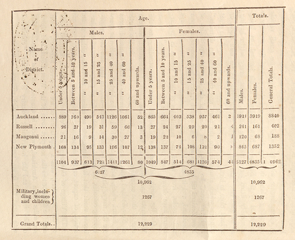
CENSUS
OF THE
NORTHERN COLONY OF NEW ZEALAND.
NOVEMBER, 1851.