REPORT
[Image of page 5]
REPORT
ON
THE HEADWATERS OF THE RIVER RAKAIA.
TO THE SECRETARY FOR PUBLIC WORKS.
Geological Survey Office,
Christchurch, June 20th, 1866.
SIR,--I have the honor to communicate to you, for the information of His Honor the Superintendent, that I returned the middle of last month from my summer journey, during which I examined and surveyed the different headwaters of the Rakaia and its tributaries.
The Survey Department having already accurately surveyed the headwaters of the Rakaia proper, on the road to the West Coast by Whitcombe Pass and the Hokitika river, and of the Wilberforce over Browning Pass into the headwaters of the Arahura, I had thus two good base lines upon which I could fix the results of my topographical and geological examinations.
The weather was so fine that during nearly seven weeks there were only two days in which I could not pursue my regular work in the field; whilst throughout the remaining period an almost continual cloudless sky enabled me to obtain, without interruption, the necessary bearings of the different mountain summits and other points of interest.
The meteorological observations taken regularly at Hokitika assisted me, in conjunction with those of the Christchurch station, not only in verifying many calculations of altitudes made during my previous journeys, but also in calculating other new ones with a greater degree of accuracy than those formerly obtained. This was principally the case with the altitude of our alpine passes, where the reading of the barometer seems to be more affected by the West Coast climate than by that of the East Coast. Thus, by making use of the observations of both stations, it is evident that a more correct result can be obtained in calculating the heights in the dividing range, than from only those of either coast alone, when there is often a great difference in the readings, of which I gave some instances in my Report addressed to the Secretary for Public Works, November 18, 1865.
I beg once more to repeat that all altitudes obtained by merely barometrical measurement can only be considered fair approximations;
[Image of page 6]
but, at the same time, I feel sure that many of them, owing to the favourable state of the weather during which they were taken, when compared with those taken by means of the spirit-level, will not be found far from accurate.
I append a table of altitudes to this Report, with some notes in explanation.
Last year I had the honor of presenting to you four sections of the different passes across the central chain, with a comparative section on which each line of road was shewn in a distinct colour. In order to complete this work, I have prepared a fifth section, from the mouth of the Avon, east, to the mouth of the Hokitika, west, across Whitcombe Pass, and added it to the comparative one above mentioned.
Thus the details of the five principal passes across the Southern Alps are accessible to the public for comparison, and will be found to exhibit some very curious and instructive physical features.
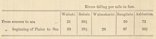
In my Report on the Formation of the Canterbury Plains, dated September 2nd, 1864, several tables, shewing the fall of the different rivers then examined by me are given, not only for general information, but also to test the theories advanced in that Report on the power of the rivers to scour new channels in their former beds, when the physical conditions of their sources have become changed. I have appended to this Report two more tables, shewing, first, the fall of the Rakaia and of the Hurunui, the details of which I calculated during my journey to the West Coast last year, and secondly, a new comparative one.
It will be found that both river-courses confirm entirely what I stated in that former Report, and it shows well that the Rakaia, according to its volume of water, second only to the Waitaki, has, after that, the largest river in our Province, the least fall. I refer you to the notes appended to these tables, as well as to a comparative section, expressly prepared for the purpose in which the different rivers are drawn in distinct colours. There remains only the Waimakariri, the examination of which I shall undertake during next summer, which will complete the river system of our Province, if I except the West Coast rivers, of which I can only offer sections of some of the principal.
I shall begin my notes with the western termination proper of the Canterbury Plains, which may be considered to extend to Fighting Hill, a roche-moutonnee stretching to the gorge of the Rakaia.
After having crossed the Acheron, and ascended the alluvial terraces deposited upon morainic and lacustrine deposits, we arrive at the
[Image of page 7]
moraines lying across the eastern end of Lake Coleridge, a true lake basin, of the formation and physical features of which I shall speak in the sequel.
The new road to Browning Pass leads across these moraines and along the hills on the southern side of Lake Coleridge, where well-defined glacier shelves give evidence that here--about 2000 feet above the present bed of the Rakaia--the whole valley was filled with enormous ice-masses, which terminated only on the Canterbury Plains, four miles below the gorge, extending in a semicircle from the eastern base of Mount Hutt to the Malvern Hills.
At some spots fifteen of these glacier shelves were visible, one above the other, with a fall of from 10 to 12 deg. towards the east.
Instead of following the new road to the ferry near Goat Hill I descended about 450 feet by the dray-road, which leads to the stations of Messrs. Palmer and Neave, on the banks of the Rakaia proper. A section in the banks of the river is exhibited in a terrace, about 100 feet high, consisting of fluviatile beds, often worked by the power of running water into grotesque shapes. The valley of the Rakaia opens here considerably, and is at the junction about two miles broad, through which the river meanders in many branches. Two interesting roches-moutonnees lie here in front of the landscape, of which one, Woolshed Hill, lies between the junction of the Wilberforce branch with the Rakaia, whilst the other, Double Hill, is situated in the centre of the valley, and derives, without doubt, its existence from the union in post-pliocene times of the two glacier branches coming from the Rakaia and Mathias valleys. Another interesting view is towards the deep valley between Mount Hutt and the Palmer range, where a smaller branch of this huge glacier descended towards the Canterbury Plains, through the northern branch of the Ashburton. This valley is about 1200 feet above the Rakaia, and has very well developed terraces. From some rocks exposed on its face it is called Redcliff Gully, which colour is the effect of rubefaction of tertiary limestone beds. As I intended to visit this spot at a future period by ascending the northern branch of the Ashburton, I requested Mr. Francis, manager of the Double Hill station, to obtain some specimens for me from that locality, to which he kindly complied. The specimens sent to me consist of a fine semicrystalline limestone, very valuable for lime-burning.
It is not possible to obtain a view from that point towards the head of the Rakaia, as the Arrowsmith range deflects its course, so that this splendid mountain chain, forms the background of the landscape.
The Wilberforce, which we had to cross near its junction with the Rakaia, was a little swollen from a previous north-west storm, but being here divided into several branches we forded it easily on horseback.
[Image of page 8]
I devoted the next day to examining the isolated Woolshed Hill, previously alluded to, a true roche-moutonnee, showing in many spots the striae and flutings accompanying glacier action. It consists in its southern portion of very hard dioritic or siliceous sandstones, changing into conglomerates, which, by their hardness, offered great resistance to the ice-masses. But still more instructive is the succession of beds lying above them. Going north along the banks of the Wilberforce, which here rushes against the nearly perpendicular rocks, they soon disappear, and large fluviatile deposits, forming walls often 150 to 200 feet high, the character of which is well exposed in the vertical cliffs, are washed by the river. These beds are roughly stratified, and alternate with small layers of fine grey or yellow silt, the product of the triturating power of glaciers. On the summit of this hill we observe a well-defined river bed with terraces leading along it in a south-east direction. Thus we have ample evidence that when the great post-pliocene Rakaia glacier retreated, a lake was formed, in which the Woolshed Hill, among others, stood out as an island. This lake, in the course of ages, was partly drained by the formation of the lower Rakaia gorge, and partly filled by the debris brought down by the river, which again, as its sources retreated more towards west and its volume diminished, lowered its bed to the present level.
The old river channel which has been formed on older deltaic deposits and lacustrine beds, now lying 100 feet above its present river bed on an isolated hill, is thus a very curious and instructive instance of the former history of our alpine rivers. Approaching more towards Mount Algidas, the high mountain between the two main branches of the Rakaia, palaeozoic rocks make again their appearance rising about 400 feet above the river; upon them no alluvial beds are observed, and huge angular blocks, true erratics, often perched on the steep sides, give evidence that they were left behind when the glaciers retreated.
On travelling up the river, these older contorted strata soon disappear again under well stratified alluvium, which reposes towards the north upon tertiary strata, consisting of argillaceous sandstones, sometimes replete with pieces of broken shells. Although always in a fragmentary state, I succeeded nevertheless in finding some characteristic pieces of Pecten and Cucullaea, showing that they belong to our lower tertiary series. Below them again we meet loose quartz sandstones with harder ferruginous bands changing into clayey beds, sometimes without any apparent stratification, and full of nodules of clay ironstone, and sometimes small concretions of iron pyrites.
These beds rise the more we approch the southern base of Mount Algidas, till they have a dip of 68 deg. towards east, and overlie ligniti-
[Image of page 9]
ferous strata, of which only a small portion is exposed near Mr. Neave's home station. If we cross oyer here from the Wilberforce to the valley of the Rakaia proper, we again meet morainic accumulations reposing on these strata. The occurrence of this tertiary outlier is of great interest: it shews us not only that in the tertiary period some of the large valleys existed in the lower portion of our Alps, which, when submerged, were filled with extensive tertiary strata; but that afterwards, in the ice-period, which succeeded the rising of the land, these extensive tertiary beds were mostly removed and still deeper and wider valleys were excavated by the huge ice-masses. This is particularly conspicuous when looking at the angle of the mountain slopes on both sides, which, some distance above the altitude of the glacier shelves, are much steeper, and shew at a glance that they have been cut down by the action of the ice during the epoch in which the glaciers had their greatest extension. Only at some favourable spots have small remnants of these tertiary strata been preserved. It is evident that these beds and all those more extensive ones lying to the west and east of the Rakaia gorge, reposing upon the trachytes which cross from the Malvern Hills to the eastern base of Mount Hutt, have been deposited simultaneously after the formation of the great line of fracture, from which first quartzose trachytic matter was emitted, followed, between and after the deposition of the tertiary strata, by sheets of basic or pyroxenic lava.
I may here allude to another tertiary outlier in the gorge of the Acheron, five miles above its junction with the Rakaia, the existence of which is revealed in the nearly vertical banks of that river. Doleritic lava has here issued from a secondary focus, ascending and flowing over tertiary beds, visible for about 300 feet. These doleritic rocks, immediately above them, have an earthy character, and a tendency to globular structure, they are greenish black, and have imbedded in them many small crystals of augite, copper-coloured mica (rubellan), and small grains of titaniferous magnetic iron.
At a distance of about 200 feet from the tertiary strata the rock becomes of a harder and finer texture, and is filled with a great quantity of large crystals of augite. The hill itself, which, by its hardness, has well resisted the ice-action, has assumed the form of a true roche-moutonnee.
Although the occurrence of this volcanic rock was in this locality of great interest to me, the examination of the tertiary beds thus preserved were still more instructive: they consisted originally, in descending order, of clay-marls, with some bands of limestones, oyster-beds and shales, with a few small seams of brown coal, and below them blueish clay-marls. Close to the dolorites the clay-marls are changed into porcelain
[Image of page 10]
jasper-like beds, the calcareous strata have become impregnated with silica, and resemble chertose rocks, with occasional concretions of chalcedony. The shales have become hardened and taken a distinct slaty structure, covered with an efflorescense of sulphur: the oyster-beds have also become hardened and partly silicified, the original structure of the shells being still preserved. The brown coal itself has undergone most remarkable changes, either by assuming a dirty yellow or brown colour, and shewing a perfect woody structure (silicified), or exhibiting all the characteristics from a pitch coal to a true anthracite. The seams are very small, generally only a few inches thick, and therefore of no practical value.
Thus we recognise with pleasure that the changes to which volcanic rocks have given rise in the Northern Hemisphere, as, for instance, at the Meissner in Hessia, are the same as occur in the distant antipodian New Zealand.
Having decided to ascend, first, the principal branch of the Rakaia, to which has been preserved the original name, I followed the track leading from Mr. Neave's home station along the base of Mount Algidas to the Mathias branch. This river, containing much less water than the Rakaia, has advanced with its fan considerably towards the main stream. At the same time, a very large shingle cone of the Chimaera creek, several miles in extent in each direction, preserving the base of Mount Algidas from the encroachment of the Rakaia, has given existence to extensive swamps, which are impassable for man or horse. Similar swampy tracts exist in nearly all our rivers, below the junction of an important branch. The main river itself, at its junction with the Mathias, flows in a narrower channel than usual along the northern base of Double Hill, but being bounded also on its northern side by rocks, which rise in an isolated hill to an altitude of 30 to 40 feet above the river, another instance that running water, when lowering its bed, will more easily cut through the solid rock than remove the beds of shingle deposited during the raising of its bed in an anterior epoch.
Magnificent weather had set in, and the rivers fell very low, so that the crossing of the Mathias could easily be accomplished, even on foot. At the junction of this river with the Rakaia lies another long low spur, having all the characteristics of a roche-moutonnee, washed by a water-course formed mostly by the drainage from the Rugged Range. Good sections are exposed in numerous localities. The same dioritic sandstones, clayslates, indurated shales, of which the Alps all along their eastern flank are mostly composed, but without any limestone, are also observable. Fagus Solandri, the white birch of the settlers, which was hitherto the prevailing tree, now begins to occur more in groves, and sub-alpine shrubs and trees,
[Image of page 11]
belonging principally to the Compositae, Scrophularineae, Rubiaceae, Ericeae, and Coniferae, are mixed with that handsome sub-alpine tree, giving to the landscape a park-like appearance, the effect of its fine shape and foliage being heightened by the various tints, from pale greyish green to dark brown, by which it is surrounded. This lower vegetation is succeeded by alpine meadows, studded with flowers, over which the rugged weathered rocks, forming gigantic peaks, rise in wild majesty.
A large flat continues for about six miles on the northern side of the river, presenting good travelling ground, formerly closely covered with Wild-irishman (Discaria Toomatoo): This scrub is fast disappearing before the cattle-farmer, who prepares the ground for the use of his herds by burning that noxious and spinous vegetation. Before us the splendid Arrowsmith range rose every moment more and more conspicuously, forming the back-ground of the valley with its splendid peaks and needles. The ranges on the northern side of the river began also to assume a more alpine character; the fagus vegetation became still more intermixed with sub-alpine pines and shrubs, whilst above them the alpine meadows began to descend lower. Deep gorges on the mountain sides led towards glaciers of the second order crowning the high rugged summits, and here, again, the contrast between the broad level valley and the alpine ranges rising abruptly from it, struck me forcibly as one of the great characteristics of the Southern Alps.
We passed the valley by which the Cameron enters the main valley, bounded on both sides by roches-moutonnees, and which forms a remarkable break through the eastern ranges, as it unites the valley of the Rakaia with those of the Ashburton and Rangitata. Seven miles above the junction of the Mathias the river sets against its northern banks, which are covered with dense vegetation, and rise nearly perpendicularly above the water for a considerable altitude. It was therefore necessary to cross to the other side, and although the river was low, it was not a pleasant task, owing to its rapid fall and the large boulders in its bed. The semi-opaque, milky colour of the water, in conjunction with the low state of the river, showed at once that it is derived from large glaciers, whilst its temperature--46.6 deg., the air being 61.8 deg. --proved that we were not many miles distant from that source.
Our road lay now on the southern side across a grassy flat, mostly overgrown with the same dense vegetation met with on the banks of all our river-flats, namely, the spiny Wild-irishman, and the bayonet-like Spaniard, (Aciphylla Lyallii). We crossed some considerable watercourses, mostly from glaciers of second order, which enter the valley from the Arrowsmith range.
[Image of page 12]
Arrived at the point which projects most into the river bed from that range, a very remarkable view opens before the traveller. The valley, still more than a mile wide, stretches for six miles towards the west, and is entirely covered by alluvial accumulations, often consisting of large blocks, over which the river rushes with fury, frequently divided into several branches. The aspect of such a valley is bleak and cold in the extreme, for at a few miles distance it is not possible to distinguish the turbid water of the meandering river from its banks, and the whole forms one dark grey mass ascending towards the head of the valley. There, instead of finding as usual, a large glacier filling the whole valley, I observed a true roche-moutonnee, reaching half-way across from the southern side, whilst from the northern side and opposite to it a glacier of considerable dimensions crossed the remaining portion of the valley, abutting apparently against the almost vertical northern side of this rounded hill. But I may observe that west of this roche-moutonnee there is another valley, and that between the glacier and the hill a torrent rushes down, washing the southern flanks of the former, and thus prevents it from abutting directly against the hill. High snowy ranges in fantastic forms rose above, but owing to their distance and the considerable width of the valley they did not impress the mind with their truly gigantic dimensions, with which I became subsequently better acquainted. The fagus forest ceases here, at an altitude of about 2500 feet, and dense sub-alpine forest vegetation covers the lower regions.
The course of the river compelled us again to cross to the northern side, and, although I selected the best ford, the boulders were so large and the rush of the water was so strong that the horses could only stand against it with difficulty.
We camped the evening of the 13th March about a mile below the junction of the Whitcombe Pass stream, at the edge of the sub-alpine forest, where small grass flats offered feed for the horses, and where at the foot of an avalanche channel, formed last winter, a great quantity of firewood was easily procured without the trouble of cutting it.
The dimensions of the valley and surrounding objects are so great that the large glacier crossing it, and covered entirely with debris, seemed, at a few miles distance, more like a small shingle fan, partly destroyed on its lower end, than a huge mass of ice, the dimensions of which only become apparent when you are standing close to, or on the mountain range above it.
Wednesday, March 14.--I started at daybreak, accompanied by one of my men, to ascend Whitcombe Pass. The Pass stream contains a good deal of water where it enters the bed of the Rakaia on a large fan, but
[Image of page 13]
looses itself by degrees in the shingle before reaching the main river, so that we crossed it dry-footed, following along the edge of the main river to its right hand bank. From here the remarkable opening through the Southern Alps is clearly defined, with the peak of Mount Whitcombe on its western side, raising its bold snow-covered summit above the lower ranges in front. After passing across a shingle terrace for a few hundred yards, we reached a spot where the valley assumes a gorge-like character, and we were compelled either to travel along the sides, through dense scrub, or keep to the bed of the river, which had now become a true mountain torrent, with large boulders forming its banks.
Numerous sections gave me an insight into the geological structure of these ranges, but without offering any new data, as the strata were similar to those so often oberved and described all along the eastern base of the central chain proper. Dioritic sandstones, slates, conglomerates, and indurated shales follow each other in endless succession, so as to indicate clearly the changes on the palaeozoic sea-bottom on which they were deposited. Not the least sign of fossil remains or tracks of animals could be detected. These strata, forming huge foldings, belong also to the unauriferous series, covering, for many thousand feet, the auriferous rocks exposed on the western slopes of the same range.
After a mile we had to cross a torrent descending from a glacier of second order, which was hanging on the mountain side like a gigantic icicle. Here we had the first view of the saddle, which, apparently, was situated only a few hundred feet above us, and seen from that point of observation, seemed to consist of a shingle wall, not more than 100 feet high. After another mile of labourious walking, we arrived at a very considerable branch, which descended in a succession of falls over and between enormous blocks, from a true glacier, descending from the eastern flanks of Mount Whitcombe, the summit of which was visible from here, rising in a magnificent rocky pyramid.
Having examined this glacier, which I named the Ross Glacier, and taken some altitude observations, we crossed the foaming torrent issuing from it, to accomplish which requires steady nerves. We had then to ascend the hill side and to wind our way through dense alpine vegetation, which was growing luxuriantly amongst great rocks, mostly the remains of a former moraine extending so far. Owing to the aspect of the valley, and being accessible to more moisture from the west than other similar ones in the Alps which are protected by the lofty ranges in front, many shrubs and annual and perennial herbaceous plants, already in seed in other localities, were here still in full bloom, and I was able to collect many interesting specimens, of which several are new to science. After half a mile of this slow and tiresome travelling through vegetation so
[Image of page 14]
dense that it often allowed us literally to walk on the top of the branches, we descended again to the river bed, and an equal distance climbing over huge boulders brought us to the shingle wall which stretches across the valley, and along which the river flows on the eastern side, issuing from the central chain near the summit of the pass. Even alpine shrubs disappear here, and ascending the saddle a close grown carpet-like turf, is found to cover the hill sides, except where shingle slips or rocks occur. This turf, notwithstanding the lateness of the season, was studded with innumerable flowers, mostly belonging to the orders Ranunculaceae, Compositae, and Umbelliferae. Amongst the latter a small but very handsome new Aciphylla was conspicuous, remarkable from the contrast of its bright green leaves with a red line in the centre, red spines and black seed. A Nestor Notabilis, the fine green parrot of our Alps, came screaming down from its lofty height to have a look at the intruders, and was shot--a very welcome addition to our collection. I may here observe that the maori name, Khea, is very characteristic, as it conveys an exact idea of the loud shrill call of this remarkable bird, which seems to be fearless in the presence of man, of which I had many striking instances during my journeys.
Having ascended about 200 feet on a steep gradient, the terrace becomes more level, and the torrent, running now nearly parallel to the ridge, becomes again visible. On the eastern side the central chain is also covered with large snow-fields, and is here crowned by a pyramidal peak, which I named Mount Martius, and from which a glacier descends to within fifty or sixty feet of the saddle. Thus the southern side of the pass is formed by the bed of the outlet of this glacier reposing upon morainic accumulations, and in looking at the mountain slopes on both sides of the valley, clear evidence is presented of the former extension of the ice-stream. Having examined and fixed the altitude and position of this glacier, I visited some lagoons which were situated south of the shingle-bed of the Whitcombe Pass stream on some lower ground, and which were bounded still further towards the north by what appeared to be morainic accumulations reposing upon the eastern side of Mount Whitcombe.
A rich vegetation grew round these waterholes, and among the flowers a magnificent large Ranunculus, with yellow blossoms was conspicuous.
A further ascent of about 40 feet over enormous blocks of rocks lying in a narrow channel, formed by two talusses of debris, brought us on the summit of the pass. The barometer at one o'clock, read 25.94, theremometor 54.2 deg. It was a magnificent day, only a few Cirro-cumuli rose in the north, disappearing soon amongst the wooded ranges which formed the horizon towards the West Coast.
[Image of page 15]
A considerable sized torrent descends on the western side of the pass into a shingle valley, which, for about eight miles, is nearly straight, with occasional grassy flats on its banks. On both sides the mountain chain rose majestically above the valley, mostly covered with snow-fields, from which numerous glaciers descend, the outlets of which swell the body of this, the most important of the sources of the Hokitika river. The contrast is very striking between these rugged alpine ranges and the quiet outlines of the West Coast mountains, 4000 to 5000 feet high, heavily timbered to their summits, which close the horizon, and through which the river forces its way in a succession of deep gorges. The stupendous mass of Mount Whitcombe rises here so steeply above the pass that only very little snow can cling to its sides, making it appear still higher and wilder. It consists of hard siliceous sandstones, alternating with dark clay slates, having a fall of 78 deg. towards south, and striking across the pass. The reading of the barometer at that time in Hokitika, as I afterwards ascertained, differed only from that at Christchurch by 0.01 inch, and a double set of observations gave me, as mean result for the summit of the pass, 4312 feet above the sea level.
On skirting the wall of debris on the western side of the pass, I came, after having descended about 30 feet, to the terminal face of a glacier of considerable dimensions descending from the north-eastern flanks of Mount Whitcombe, and filling a deep cauldron-like valley.
When examining the other alpine passes of the Province I observed that invariably a glacier descended on each side, going in opposite directions, and although on the ranges above some of them true glaciers lie, now several thousand feet above the watershed, the glacier shelves and remains of lateral moraines, with which the surrounding mountain sides are covered, shew at once that much larger glaciers existed formerly in those localities. These extensive ice-masses have, without doubt, planed the central range on both slopes in opposite directions, till the ridge has been worn down to its present form. Here, on Whitcombe Pass, this instructive phenomenon is still visible, as the Sale glacier reaches now across the valley, and if the Martius glacier would only advance a few hundred yards, the moraines of both, and perhaps the ice-masses, would meet on the summit of the pass, although descending in different directions. Mr. Hector made the same observation in the Otago Alps, and thus we observe how nature, to obtain gigantic ends, uses very simple, but effectual means for their accomplishment. In fact, no more simple method could be devised to grind down part of an inaccessible mountain chain than these ice-ploughs, or perhaps, better styled ice-planes, working in opposite directions, which thus open a passage through an otherwise impassable barrier, and allow commerce and civilization to unite the shores of this rich and beautiful island.
[Image of page 16]
Although not pertaining to my vocation, I may be allowed to offer a few observations on this pass, in a practical point of view, with regard to forming a road across it.
The gradient from the junction of Whitcombe Pass stream to the summit is so fair that there would be no engineering difficulty in constructing a dray road, although it would entail great expense. The road, for the first two and a half miles, would have to be kept mostly on the eastern side to avoid the glacier torrents, the beds of which, consisting principally of gigantic blocks, are shifting continually. The road would therefore have to be blasted out of the rocky shelves which, for that distance, form mostly the eastern side of the stream. Arrived at the summit of the saddle, another, and serious, difficulty presents itself in the lateral moraine of the Sale glacier, which is constantly shifting, owing to the motion of the ice, and it would therefore be necessary to work along the western base of Mount Martius, which consists here of a succession of shingle-slips and enormous blocks piled loosely together. The descent towards the West Coast is more rapid, particularly for the first 300 to 400 feet. For ten miles the open bed of the Hokitika torrent would not present many difficulties, except from the accumulation of snow and avalanches. The two parties who previously travelled across this pass, under the leadership of Messrs. Whitcombe and Harman respectively, have made us acquainted with the great difficulties which exist in following this road across the woody West Coast ranges, so that I need not allude to it any further.
I spent the next day in arranging my collection and notes, and the following being wet I was only able to continue my researches on the 17th March, when I started on horseback to visit the glacier stretching across the valley. It was a beautiful day, the atmosphere clear and pure after the rain, and the aroma of the white flowering Carmichaelia odorata and the splendid Senecio cassinioides was so strong that the whole air was filled by it; the latter was, in many localites, so thickly covered with yellow blossoms that scarcely any leaves could be detected.
Shortly before arriving at the glacier, we came upon a herd of about 25 head of cattle feeding on the mountain sides, and their sleek forms and unexpected appearance in this solitary spot, reminded me of many a similar scene I had observed in the Alps of Switzerland.
We were able to ride to within 300 yards of the glacial cave, but then the raging torrent issuing from it set against the rocky banks, so that it was impossible to proceed any further. I therefore ascended the mountain side, which was formed by ice-worn rocks, and soon stood in front of this remarkable glacier, over which the wild stupendous moun-
[Image of page 17]
tains rose in sublimity and grandeur. I shall leave its description to another portion of my narrative, when giving an account of my ascent of Mein Knob, the remarkable roche-moutonnee lying between the two glaciers. The glacier itself is near its terminal face, 150 feet high, entirely covered with debris. Its principal outlet flows from an ice-cavern close to the mountain side. Large stones were continually falling down from the summit of the ice into the foaming waters below.
My next object being to try if I could not pass along the southern base of the glacier, we led our horses along the present bed of the river, consisting often of very large blocks of rock, in search of a ford, but had to return nearly a mile before I could find a spot where the horses were able to plunge through the swift and muddy water rushing over the large rocks, which offered very bad footing.
With the least freshet in the river it is impossible to cross so near the glacier as this, and the most serious consequenses might follow such an attempt.
Arrived at the southern terminal face of the glacier, I observed here also several minor streams issuing from below the ice, which rose in a nearly perpendicular wall, washed by another glacier torrent of considerable size.
This latter was confined, on the other side, by the rocky walls of Mein Knob, forming a narrow gorge. I tried in vain to pass along, but, partly owing to the slippery nature of the ice against which the turbulent waters were flowing, partly to the huge blocks of rock falling from the top of the glacier, and the almost continuous shower of smaller debris, I had to give up the attempt to reach the upper part of the valley by skirting this, which I have named the Ramsay Glacier. Two barometric observations taken at its terminal face give its altitude, above the sea-level, 3354 feet. This glacier is, therefore, next to those at the head of the Pukaki system, the lowest on the eastern side of the central range of this Province.
On returning from this trip I observed a hut, the roof and walls of which were formed of thatch, built by Mr. Harman's survey party last year, before crossing over to the West Coast by Whitcombe Pass, and as an inspection shewed me that it was in a habitable state, we broke camp that evening and took possession of it, as it offered us more facilities for the better preservation and preparation of our collections, which began to augment already considerably.
The magnificent weather continued to favour us, and when I started next day, the 18th March, to reach, if possible, the upper part
[Image of page 18]
of the valley by ascending and crossing Mein Knob, no cloud was visible on the deep azure sky, and the atmosphere was so clear that every detail on the slopes of the snow-covered giants around was distinctly visible. Travelling across a river-bed near a glacier with horses is always tedious, not only from the large boulders forming it, but also from the numerous dry channels by which it is furrowed. We forded the first, or Ramsay Glacier branch easily opposite our camp, and found that the other, issuing from the upper, or Lyell Glacier, kept, for a long distance, under the southern banks of the valley, so that we had to travel to within half a mile from the hill in question before we reached a spot where the water was flowing between two shingle banks. But when I tried to cross, the water was so rapid and the boulders were so large that I had to give up the attempt, and re-descending the torrent seek a ford lower down. I found at last a good crossing place, although with rocky banks on the other side, with a small shingle flat adjoining, offering dry footing for the horses, which we could not take any further. We proceeded on foot, partly through the water, partly over the rocks, or through the dense scrub on the mountain sides. Another impediment, in the form of a wild mountain torrent, presented itself in our track, coming from the north-western slopes of the Arrowsmith range, but after following it for about 200 yards I found a tolerable crossing place.
Mein Knob is covered on its eastern slopes to within 300 feet of the summit with a dense alpine vegetation, the branches, as usual, growing downwards, being impenetrable, at least to ascend through without cutting a track, which would have caused much delay. I therefore selected the northern slopes, opposite the terminal face of the Ramsay Glacier, which consist in their lower portion of a great talus of loose debris, near the summit of steep, rocky cliffs, over which we climbed. Approaching the summit, the rocks disappear under a densely grown grass-like carpet of alpine vegetation, studded with flowers, but in many places of a very treacherous nature. The approaches to the summit are formed by gigantic blocks, with the interstices between them grown over, so that when walking the foot often falls through the covering of plants. At some spots small caves were formed by these erratic blocks perched in every possible position, and deposited when the glacier retreated and separated into its two branches. Some well-defined striae and flutings were occasionally preserved on the face of the rocks, which had the smooth, rounded outlines so peculiar to glacialized countries, although generally crumbling away and splitting into polyedrical blocks, the result of numerous joints running in various directions.
The summit is about half a mile broad, and covered by a succession of bosses, amongst which, at different elevations, lie several small lagoons. The view from here is magnificent in the extreme, and can fairly rival
[Image of page 19]
that in any part of our Southern Alps. To the west a large valley opens, about three quarters of a mile broad, in which a glacier of considerable dimensions is situated. This glacier, which I named the Lyell Glacier, reaching nearly to the western base of the hill on which I was standing, is entirely covered in its lower portion with debris, but higher up it shows its structure in many seracs by peculiar green and bluish hues. Round the glacier rose peak upon peak, sending down their ice-streams. Amongst them the rocky pyramid of Mount Tyndall was conspicuous, enveloped in vast snow-fields. It was with pleasure that, although standing on the opposite side, I recognised some of the other peaks which I observed first when at the head of the various branches of the Rangitata. I thus obtained such data as will enable me to fix, with some degree of accuracy, the position and orographical features of that portion of the central chain.
Although this view towards west was magnificent, that towards north could claim my admiration no less. A high dome-shaped mountain, covered with snow and ice, which I named Mount Kinkel, lies between the two glaciers, separated from my station by a deep gorge, in which the outlet of the Lyell rushes down against the Ramsay Glacier. The latter strives, but ineffectually, to bar the way of the torrent, the waters continually undermining and destroying the ice. Another majestic mountain range lies between Mount Kinkel and Mount Whitcombe, which I named Mount Ramsay. It is impossible to convey in words an adequate idea of the rugged character of this mountain and its eastern neighbour Mount Whitcombe; turrets, pinnacles, and minarets rise all along the serrated edges, and the rocky face is, in most instances, so steep that no snow can lie upon it. Mount Whitcombe, which when seen from the pass, appears like a rocky pyramid, extends considerably in breadth, its outlines rugged in the extreme, can scarcely be surpassed by any other mountain. The Ramsay Glacier descends in three branches in deep valleys between the mountains, augmented everywhere by tributaries descending from the mountains around, on which lay large snow-fields wherever the ground is not too precipitous. The trunk glacier is also covered by moraine debris in the centre, below the junction of the two main branches. The distance between the two glaciers is about half a mile. The main valley, in which lies the Ramsay Glacier, has a cauldron-like appearance in its northern portion, Mount Whitcombe rising steeply above it. A small but beautiful glacier descends also from Mount Arrowsmith, from which flows the torrent we had to cross on our way up.
For several hours I was occupied taking the necessary bearings, and making a sketch of the glorious scenery before me, a copy of which I append to this Report, but which conveys a very inadequate impression of its real beauty. It was only towards evening that I reluctantly turned away from the panorama, which for diversity of scenery and its wild alpine character, is second to none in New Zealand.
[Image of page 20]
Animal life was very scarce, and the only living creature I observed was a Pukeko (Porphyrio melanotus), the Swamp-hen of the settlers, standing near one of the lagoons. This is the first time that I met this bird so high up amongst the mountains. But what struck me more than anything else as singular was a clearly defined track, about one foot wide, which ran over the hills in various directions, generally leading from one lagoon to another. When crossing the grass or dwarf plants, which formed a dense matted carpet, this track was worn down, though not always to the ground, so as to entirely destroy the vegetation. It was too broad, yet not deep enough for sheep or cattle, which moreover, could never by any possibility have reached this spot surrounded by impenetrable scrub, snow-covered mountains, and raging torrents. My companion, who examined them closely, following them in all directions, while I was busy sketching, and who is well acquainted with the tracks of sheep on mountains, was also quite satisfied that they could not have been caused by those animals. Similar marks were observed by Dr. Hector on the Pigeon range and elsewhere on the West Coast. I also met with some but not so clearly defined ones on Mount Brewster above the sub-alpine vegetation. Dr. Hector thought they were formed by the Kakapo, whilst I attributed them to the Khea (Nestor notabilis), but after having conversed with that eminent geologist I inclined to his opinion. Still, considering that no Kakapos are found on this side of the range, or I should have heard their call in the night, and that the green alpine parrot is very rare, I really do not see how either of these birds could have formed them, and we must leave the solution of this curious problem to future investigation.
For botanical purposes I returned to the foot of the hill through the bush, a herculean task, particularly for one who is of portly dimensions, as we had often literally to lie flat on the ground and crawl through or to walk on the tops of the branches. But a rich harvest rewarded me, as I collected amongst others several beautiful Olearias, covered with fragrant flowers, one of which, at least, is new to science.
It was nearly dark when we reached the hut, a pleasant spot in the solitude of that interesting region. The water in the river when we crossed it towards sunset had risen considerably, and become much more opaque, a usual result after a warm, sunny day among the Alps.
The following day I devoted to the geological examination of the surrounding mountains, and to collecting specimens of natural history.
Tuesday, the 20th March we returned, and at noon on the following day camped on the right hand bank of the Mathias, near its junction.
[Image of page 21]
When rounding the spur of the Arrowsmith range the contrast, looking east and west, is very striking between the rugged character of the Alps and the singularly rounded outlines of the eastern ranges. In the foreground and centre of the valley stands the characteristic Double Hill, above it appear the sugarloaf shaped hills which surround Lake Coleridge, and over all the long, flat Thirteen-mile bush range bounds the horizon. Having observed lately at the Francis Joseph Glacier, on the western side of our Alps, how ice perceptibly rounds and moulds the rocks in its way, not much imagination was required to fill again the whole valley with a sea of ice, planing and furrowing those hills on a more gigantic scale. I may here observe that 1500 feet above Meins Knob, which, according to my calculation, lies 1137 feet above the sea, or 1083 feet above the terminal face of the Ramsay Glacier, numerous glacier shelves and lateral moraines occur on the southern side of the mountain, which slope down so regularly towards the east that I could take their angle, which I found to be 6 deg. in the average. Thus it appears that the valley was here filled with ice at an altitude of nearly 6000 feet above the sea, and yet this was certainly not during the greatest extension of the post-pliocene glaciers, judging from other phenomena observed everywhere in still higher regions.
Thursday, March 22nd.--I started to examine the sources of the Mathias, the most important tributary of the Rakaia above the junction of the Wilberforce. Having passed over the fan of the Chimaera, a small creek flowing in a deep rocky valley from the Rolleston range, we had to ascend another similar fan, belonging to the Camperdown creek. It is remarkable what enormous masses of debris these two creeks, now so insignificant, have brought down with them, forcing the Mathias to keep close to its western bank. These fans, of which that of the Chimaera is by far the largest, rise to about 300 feet above the river, and are more than two miles across. Beyond the Camperdown fan, following a cattle-track, we came upon a large flat, lying about ten feet above the present water-course of the river, still partly covered by its primitive vegetation, a dense thicket of Wild-irishman and Spaniards, through which we had to force our way. On both sides of the valley very remarkable glacier shelves occur, in fact the whole is exceedingly worn down, and numerous roche-moutonnee-like hillocks lean, in many localities, against the higher ranges. Six miles from the junction of the river with the Wilberforce its present shingle-bed narrows considerably, and a moraine, 10 feet high, crosses the valley, through which the river has broken a passage, exposing, on the eastern side, its peculiar structure. Huge angular blocks, derived from the central chain, lie indiscriminately one over the other, and an examination showed that the interstices between them were filled with debris, also derived from near its summits. Thus the same phenomenon which I observed in some of the smaller tributaries of the Waitaki and Rangitata occurs also here, pointing either to
[Image of page 22]
a temporary halt of the retreating glacier or to an advance of the present ones since the great ice period. The natural features of the country under consideration would, in many instances, at least point towards the adoption of the latter hypothesis. Behind this moraine the valley widens again considerably, as in other rivers under similar conditions, and is filled with a large shingle flat from side to side. The valley which hitherto kept a N. W. and S. E. direction takes a sharp turn about eight miles above the junction, and comes from the north. Here an important tributary, in two branches, joins it from the west. The stream now begins to flow between narrower banks, confined more and more as we ascend by large shingle-fans coming from both sides of the rugged snow-clad mountains. Fagus forest, which hitherto had prevailed on the lower side of the valley, ceases here, where the river-bed attains an altitude of 2400 feet, and dense sub-alpine vegetation, with its various tinted foliage, clothes the mountain side.
The view from the junction of this western tributary is exceedingly grand--mountains of various forms rise higher and higher the more the eye penetrates towards the head of the valley, until they are covered from summit to foot with one sheet of snow, pierced by turrets and rocky pinnacles. For two miles more we kept along the eastern side of the valley, travelling mostly on the slopes of huge shingle-fans, and camped under the shelter of a dense group of Phyllocladus alpinus and Dracophyllum longifolium, the N. W. winds blowing down the valley with great fury. Here again the power of large snow-fields to condense and absorb clouds could well be seen; dense cumuli kept perpetually crossing the range, but soon opened and disappeared as they descended the snow-fields, and only small remnants, as cirro-cumuli, continued their hurried course towards the east, which also disappeared after a few miles more, the deep blue sky above us being perfectly cloudless. Thus these lofty alpine chains perform a most beneficial task, and, instead of being useless, are the principal cause of the fine dry climate we enjoy on the eastern side of the Province.
Next morning we started with the dawn, hoping to reach, if possible, the head of the valley. For about two miles we were able to take the horses along with us, although the river-bed was exceedingly rough, but then, owing to the large boulders, and having to cross and re-cross continually, we were obliged to leave them behind and proceed on foot. Four miles from our camp the valley assumes all the characteristics of a gorge, in which the river leaps incessantly over huge blocks. After another mile of perpetual climbing over such boulders and along talusses of debris, the valley received an important addition from the west, containing nearly as much water as the main river above. This torrent, which we had to cross near its junction, flows in a deep narrow gorge,
[Image of page 23]
having the appearance of a deep cleft, which has rent the chain from top to bottom. This valley drains a considerable portion of the central chain south of the sources of the Mathias. Another important valley opens opposite, coming from the Cascade range, but it does not contain so much water as the western tributary. The higher we ascended, the more the valley narrowed and assumed a rugged appearance: at the same time, the vegetation became strictly alpine, and many of the plants were still in full bloom, filling the air with a delicious fragrancy. A mile below the glacier a large avalanche lay across the river-bed, forming a snow bridge from side to side, through which the water had formed a tunnel. Two very prominent peaks rose conspicuously above us, of which the south-westerly one, Mount Tancred, sends a glacier down to the valley; its terminal face I ascertained to be 3788 feet above the sea. The surface of this glacier is very little soiled by morainic accumulation, and the bright blue ice was glistening in its numerous fissures and seracs. Another majestic peak, Mount Carus, lies in a northeasterly direction behind the former, but owing to the great steepness of its sides the snow-fields on it are of much smaller dimensions. Another glacier descends from the ridge connecting the two peaks in a deep gorge, and terminates a quarter of a mile above the glacier previously described. I could not reach it, but determined its altitude by means of the pocket level from an adjacent ridge, which I ascended as my last topographical station.
Thus, also here, the same great character of our Southern Alps is developed in all its principal features, and no practicable pass exists there to the western side.
A col, of an altitude of about 6000 feet, leads south of Mount Carus into the headwaters of Moa creek, a tributary of the Wilberforce, and from there by another low saddle into the course of the Stewart, the most important branch of the Wilberforce, and of which I shall speak in the sequel, when I have the same mountains again before me.
The rocks at the head of the Mathias have undergone more metamorphic action than those at Whitcombe Pass; the slates assume the character of true clayslates and are very silky; felstones and cherts are abundant; some of the slates are serpentinous, others green, coloured by chlorite. I found also some blocks of finegrained diabasic greenstone in the river-bed close to the glacier.
The general strike of the rocks is north-north-west to south-south-east, with a dip of 80 deg. to the east-north-east, but very often the strata stand perpendicular or lean over in the opposite direction.
[Image of page 24]
Three miles below the glacier on the western side of the valley, I observed in a talus of debris large blocks of indurated shales, full of impressions of fucoids, formed by minute crystals of sulphuret of iron. They lie in all directions, crossing each other frequently, some are two inches broad and more than a foot long, and if the rock were less crumbling, still larger specimens could be obtained. But I was unable, notwithstanding the most careful search, to find any sign of animal life amongst them or in the other slates which cropped out in that locality, and we must therefore assume that the conditions of the strata deposited in shallow water were either unfavourable for the preservation of animal exuviae, or that animal life could not exist in those palaeozoic seas, but it would be certainly premature to adopt the latter hypothesis.
Returning on the 24th March to the junction of the Mathias, I devoted two days to the examination of the slopes of the Mount Rolleston and Mount Algidas ranges, and in preserving and putting in order my collections. I arrived on the 27th March at Goat Hill accomodation house, where I had my horses shod and deposited the collections, which had already augmented so that they formed a horse load.
The valley of the Wilberforce presents features similar to the valley of the Rakaia. Two roches-moutonnees stand here also in the centre of the valley, Goat Hill on the right, and Scott Hill on the left, the river flowing between them. Both are joined to the high ranges forming the valley, by a succession of fans, often very large. Those low hills are also very much ice-worn, and have sloping shelves on their sides on which, and on the summit, are perched erratic blocks, derived from the central chain. The annexed sections, No. 3 and No. 5, shew the peculiar characteristic features of these valleys.
The view up the valley of the river Harper, the most important branch of the Wilberforce, is very peculiar, as numerous sugarloaf-like mountains are seen on both sides, of which Mount Gargarus, Mount Ida, and Sugarloaf Hill are the most conspicuous. Goat Hill lies about 150 feet above the river, and is about half a mile broad and two miles long, gradually narrowing and disappearing towards north under the fan of Boulder-stream gully, which is of considerable dimensions.
Wednesday, March 28th, we started up the Wilberforce, and kept along the western base of Goat Hill on the large alluvial deposits brought down by the Boulder-stream and Kakapo creek. The Wilberforce setting against these alluvial beds has washed away a considerable portion of them, and formed perpendicular cliffs in some places 60 to 80 feet high. Before reaching the junction of the Kakapo I observed the remains of a large moraine crossing the valley and cropping out of the
[Image of page 25]
lower portion of the shingle-fan of that creek. Everywhere else it is either concealed under those large alluvial deposits, or has been destroyed by the main river, showing that here also, as in the bed of the Mathias, the huge post-pliocene glaciers, when retreating to their present position, either remained stationary for some time half-way between the junction of the main branches of the Rakaia and the present glacier sources or advanced once more before they ultimately took up their present position.
Having crossed these morainic accumulations and the deposits of another small creek called the Kiwi, the present shingle-bed of the river widens considerably, and the road which has been cleared of the large boulders and shrubs, leads over grassy flats to the bed of Moa creek, the most important tributary below the Cascade range. Although quite dry when we crossed, there was ample evidence in the numerous wide flood-channels and the large drift-trees strewn over the whole bed, which was about a mile wide, that in spring or after heavy rain a great amount of water must descend by it from the high ranges which are situated about six miles to the west of the main valley. Magnificent fagus forest clothes the lower sides of the mountains which, in the Cascade range rise to a great height, and are exceedingly ice-worn, whilst numerous water-falls, from whence the range derives its name, appear like so many silver ribbons on the bare rocks, and give a great charm to this part of the road.
Ten miles above Goat Hill the Wilberforce divides itself into three branches, and the principal one, which I named the Stewart, turns to the west. Another minor one joins the main valley opposite, having its glacier sources in the cluster of ice-clad mountains, where lie also the sources of the Waimakariri and of the Awoca, the main branch of the Harper. Between the junction of the eastern creek (Sebastopol creek) and the Wilberforce, Sebastopol rock is situated; it is remarkably ice-worn, showing that the large ice-masses from the three valleys, uniting here into one stupendous trunk glacier, were so gorged that for 2000 feet above the present river-bed the pressure on the surrounding mountain sides was enormous.
The fagus forest, which at the junction of the Moa creek was growing still luxuriantly 1000 feet above the valley, ceases at the base of Cascade point, at an altitude of 2360 feet, and the usual sub-alpine vegetation begins to cover the hill side with its rich and variegated foliage.
We camped on a large flat on the northern banks of the Stewart, enclosed on both sides by the shingle brought down by two tributaries,
[Image of page 26]
with some lower ground at the base of the mountains, where a chain of deep lagoons is situated.
For nearly two miles the valley is more than a mile broad, and in this distance it is joined by three important branches, all coming from true glaciers of the central chain.
The Cascade range exhibits the same roche-moutonnee character on its northern slopes, which are exceedingly steep, and under which the main river flows, bounded by perpendicular rocks. It is cut in a numberless succession of glacier shelves, having smoothly polished rocky walls between them.
I started on the morning of Thursday, the 29th March, to follow the main branch and, after having crossed the northern one, which comes from the western slopes of Mount Park, a bold peak covered with glaciers, the main river turns towards S. S. W., and the valley narrows considerably, although still a quarter of a mile broad. Whilst the mountains on the left bank at every step assume more gigantic dimensions, those on the Cascade point range dwindle down to a ridge only a few hundred feet high, suggesting to the inexperienced that here a pass might exist, leading across the central range. In fact, we soon came upon a camping ground, where a party of diggers, bound for the West Coast, had pitched their tents, and who, to warn others from a similar mistake, had planted a stick in front, marked with the words "No pass here." One mile above the junction of the western branch the valley turns towards S. W., and the hills on the right hand bank of the stream become remarkably low, and consist of stratified alluvium, as seen in a huge slip of 200 feet high, reaching to within 100 feet of the summit of the ridge.
A traveller crossing that low ridge would descend into the valley of Moa creek, and it is evident that when the great glacier retreated, Cascade range stood as a gigantic ice-worn hill in the centre of a large valley, till the river had formed a wall of shingle between it and the central chain, in which afterwards the Stewart and Moa re-excavated their present channels. Two miles above the turn, the Stewart, the bed of which had narrowed considerably and become exceedingly rough, the turbid waters falling very rapidly over large blocks, has a west and east direction, and another smaller tributary joins it from the south.
A quarter of a mile of laborious walking brought us to a glacier nearly 200 yards broad, which descends into two branches from a high dome-shaped mountain, which I named Mount Collet, its terminal face
[Image of page 27]
is 3584 feet above the sea. The main glacier descends on the southwestern side of that magnificent mountain in a deep gorge, a low ice-worn hill separating it from the other branch near the junction. Enormous avalanches had fallen from the ranges on both sides near the terminal face, and covered it for a considerable distance with its masses, so as almost entirely to conceal the glacier. As it was so late in the season, and as the new snow-fall might be shortly expected, a great portion of these avalanches will probably remain until next summer.
The collector I had with me endeavoured during the day to obtain some quail (Coturnix Novae Zelandiae,) on the large flats near the junction of the Stewart with the Wilberforce but in vain, although I was assured that only two years ago they were plentiful in that locality. There is no doubt that very soon this handsome bird will almost entirely disappear from this Province--destroyed or driven away by cats gone wild, cattle, sheep, and dogs, and the constant grass-fires lit by the stockmen preparing the ground for their herds and flocks.
The following evening we reached the so-called Greenlaw's hut, situated a mile below the southern foot of Browning Pass, having followed the stock-road along the western bank of the Wilberforce, which offered fair travelling ground, except at a few spots where it was destroyed at the crossings of alpine torrents by heavy freshets. The hut, which, since the return of the road party to Christchurch, had been frequently used by passing travellers, was infested by numberless rats, which allowed us little rest during the night. Rain from S. W. fell during the day and part of the night, but towards morning it cleared up, and frost set in.
We started early on the following day to ascend the pass, as I wished to get another set of observations, and to examine the geological features of the ranges.
When I passed here about the end of last October on my return from the West Coast, all the ranges were covered with a uniform sheet of snow; and I was therefore doubly interested to see this portion of our Alps in autumn, when they are most free from it. The southern face of the pass was, with the exception of a large snow-hole in the Gap and a few minor ones in shady spots, entirely free from snow, but large snow-fields appeared on the slopes of the surrounding mountains flanking it. From the southern one, the Twin Peaks, the small Hall Glacier descended; the outlet of which, after a few hundred yards rapid descent, precipitates itself over the vertical cliffs in a picturesque fall. No real glacier descends from Mount Harman towards the pass, but some are to be found on its higher continuation towards the north.
[Image of page 28]
It was a cold morning and the whole country was still white with hoar frost when we arrived at the foot of the pass, having followed the bridle-track which leads to the terrace by which the shingle-slip is reached. Here the road ceases, and we ascended the shingle-slip about 600 feet, climbing along the vegetation on its eastern side till we came to the buttresses of rocks, between which the talus narrows very much. Numerous tracks of sheep showed that this road had been very much used lately; and in many spots the alpine vegetation, consisting almost entirely of herbaceous plants, had been eaten down to the ground. Here we reached the zig-zag track which is cut up the eastern rocky spur, and although steep and staircase-like in some spots it is nevertheless well laid out, and a great assistance to travellers.
About 9.30, a. m., we reached the summit of the pass by this track, and I looked around me with great interest. How different the view now to what it was last spring, when the whole surface was covered with one deep sheet of snow, hiding nearly all the remarkable physical features of this depression in the central chain. The snow had now entirely disappeared, except a few large patches in deep hollows on the hill-sides; and a picturesque lake lay at our feet, surrounded by hills mostly covered with a deep green alpine turf, thickly studded with flowers. Over them rose majestically the rugged forms of Mount Harman and Twin Peaks with their snow-fields and ice-masses glittering in the morning sun, which had just vanquished and dispersed the fog lying over them. But what struck me most was the difference of altitude at present between the lake and the ridge on which I was standing, compared with my previous experience. When walking across the deep snow lying on the lake at the end of last October, I took some observations of its altitude on the level portion near the centre; and again immediately afterwards, after ascending the gentle slopes to the gap. It became apparent that not only was the lake much more deeply covered with snow than I had anticipated, but also the slope down to its shore was much steeper. In fact, when I compared the results of the two sets of observations, which showed, in October, a difference of 98 feet only, and now it was 146 feet between the two points, I found there must have been 48 feet of snow lying on the lake at the former date, the end of October last. The observations at the gap were taken each time in exactly the same place, under a rock, which, in October, was projecting out of the snow.
Another remarkable feature, leading to some important conclusions on the formation of this pass, is the delta at the outlet of the lake, to which I shall refer again in the following pages. The water of the
[Image of page 29]
lake was perfectly clear, and had in general a stony bottom; a few grebes (Podiceps rufipectus,) were swimming upon it, and gave life to the otherwise solitary and tranquil scenery.
Large stone pyramids lead along the ridge and over the small flat, near the water-fall of the Hall Glacier, to the hills on the opposite side, where the road crosses, descending afterwards to the bed of the Arahura.
On the steep slopes leading to the lake a rich and varied flora is observed: early in the morning flowers and leaves are generally covered with a thin coating of ice, which gives them a strange appearance, but this soon disappears when the sun breaks through the mist; and these plants, some in full bloom, others budding and which look so delicate, prove their hardy nature by their bright and uninjured appearance. They were princpally Composites, umbelliferous, and, in a minor degree, ranunculaceous plants which formed this interesting vegetation. Among the first named were those which formed a thick carpet of flowers, of which Celmisia sessiliflora and Raoulia grandiflora were conspicuous, also Celmisia petiolata and Haastii and another large one belonging to the same genus which is, I think, unknown to science; there were, besides, Senecio Lyallii, with a profusion of flowers, and the magnificent Ranunculus Lyallii, with its enormous orbicular leaves. Of umbelliferous plants the dwarf Ligusticum aromaticum was to be seen growing in a thick green mat, the pigmy flowers almost hidden amongst the leaves. There were, in most localities, several tiny species of Pozoa with kidney-shaped leaves; but over all rose conspicuous the large Ligusticum piliferum, remarkable for its deeply cut leaves and its red, grooved stem. The new Aciphylla (Spaniard), first observed on Whitcombe Pass, grew here also abundantly, as well as the truly alpine Aciphylla Munroi. Several new or rare alpine species of Euphrasia, Senecio, Ranunculus, and many others, gave, in some spots, quite a gay appearance to the turf. On the small shingle reaches one of the woolly Haastias, and, as I think, a new species, is very abundant, together with the gay Ranunculus sericophyllus, then in full flower.
When walking along the edge of the lake or ascending the mountain slopes around in different directions, I was struck with the diversity of the flowers; but what impressed me most was the fact that, although winter was rapidly approaching, many of them were just making their appearance, principally round the large snow-holes still lying in many places. When I visited Mount Torlesse two years ago, in the beginning of January, most of the alpine plants were already past flowering, at a corresponding altitude, (5000 feet,) consequently, here they were three months later. Looking for the causes of this remarkable difference, it
[Image of page 30]
is natural that one of the principal will be the greater mean elevation of the country compared to the isolated ridge of Mount Torlesse, rising from the Canterbury plains. The neighbourhood of the latter mountain to the East Coast is another point of importance. But these causes would not suffice were it not that the depression in the central chain is a principal point of attraction for the moisture coming from the West Coast, and which is there condensed and precipitated principally. I have to refer you to my Report of November 18, 1865, in which I have treated of this interesting subject. At the same time I was much struck by the fact that the ranges on both sides, although only about 8000 to 9000 feet high, were covered with perpetual snow and glaciers, clearly proving that, owing to the enormous amount of moisture deposited from clouds almost continually passing through this opening, the line of perpetual snow must lie here much lower than in many other portions of our Alps.
Even the vegetation close to and on these Alpine passes differs, in many respects, to that of other alpine valleys which do not lead to any pass. Thus, for instance, a large arboraceous Dracophyllum (the Nene of the Maories), resembling, in some respects, the smaller Dracophyllum Menziesii of the West Coast of Otago, is only found on the lower passes, or, as here, near its approaches, indicating that a larger amount of moisture is necessary for its luxuriant growth than our Alps usually supply.
At 11 o'clock I found the temperature of the lake to be 46.2 deg. Fahr., whilst the air was only 37.1 deg. --a remarkable fact, considering its altitude.
Following the western shore of the lake to its outlet, we passed over some swampy ground, and at one spot a large snow-field was still lying, under-washed by the water, compelling us to ascend and cross over it. I was greatly astonished to find that a large delta existed at the outlet of the lake, over which the little creek, which we could step across, ran towards the west, cutting into it in advancing. This delta, combined with other peculiar features, proves that some very important physical changes in recent times have taken place in this part of the country. Looking at the southern face of the pass it becomes at once evident, that besides the small waterfall issuing from the Hall Glacier, another eroding power from the summit of the pass was here at work; and in crossing from the south to the north shore of the lake even a casual observer must see that the water had once its outlet here, 20 feet above its present level. At the same time the delta of the present outlet clearly indicates that in geologically recent times an important tributary
[Image of page 31]
entered there, gradually advancing into the lake. It is difficult to conceive how those changes were brought about by which the level of the water was not only considerably lowered, so that it could no longer flow towards the East Coast, but also that the delta mostly formed under water became dry, and served, in its turn, for the bed of the much smaller outlet. The only possible explanation is that a former important tributary to the lake, descending from Mount Harman, immediately below the present outlet, has, by the eroding power of the impetuous torrent, cut its channel lower, uniting with the stream descending from Twin Peaks. Thus the principal supply to the lake from Mount Harman has been cut off. This new channel is situated below the highest level of the lake, which was obliged to flow in the opposite direction, when the outlet by the Hall stream no longer existed, the more so as the new channel was continually cut lower by the same fluviatile action.
Signs of the great glaciation of that part of the country are everywhere discovered in descending the down-like hills lying round the lake on the road to Hokitika; not only are all the rocks smooth and rounded, but erratic blocks and numerous lagoons are also not missing. I followed the well selected track across these hills, descending far down the other side for the geological examination, till I came to the place where I obtained good sections free from snow during my first journey.
I returned afterwards to the western slopes of the rounded hills until I came to the place where in ascending the saddle on my previous journey I had first observed Mr. Greenlaw's camp in the Wilberforce. It is difficult to describe my astonishment when I looked down a frightful gorge with nearly vertical rocky walls about 800 feet high. It was on the snow which filled up this precipice that we had ascended five months previously. In estimating the altitude of the slope when we thus travelled up from the gully at 300 feet, I think I rather over than under estimated it; this would leave 500 feet as the depth of snow in the gorge. Only in a few localities were some large snow-holes or remains of avalanches still lying on the sides of the mountains or in the bed of the torrent, otherwise the whole was free from snow. Such a statement seems so exaggerated that I vouch once more for its accuracy, and I give it as an instance of the enormous masses of snow which accumulate in our Alps, and the power of the sun, combined with the force of the atmospherilies, (warm rain, wind, &c.,) to melt it in a short time. This point, from which the rugged, rocky sides of the wild-looking Twin Peaks rise, is 5321 feet above the level of the sea.
The rocks exposed so well on the pass consist, on the southern face, of true dark blue clayslates, alternating with felstones and dioritic sandstones, and have an average dip of 75 deg. towards W. by N. In a
[Image of page 32]
direction further north they become more metamorphic; the slates are partly siliceous, partly micaceous, the minute scales of mica being visible only with a magnifying glass, and siliceous beds, often resembling quartzites, take the place of the felstones and dioritic sandstones, the strike and dip are in the same direction, the latter nearly vertical.
Two miles lower down the Arahura, formerly called, erroneously, the Taipo, the slaty rocks become still more micaceous and silky, crossed by numerous quartz-veins containing gold. Thus also here the same sequence of the strata is observable, the rocks becoming of greater age and more metamorphic the more we advance from east to west, till we reach the Gneiss-Granites, forming the lowest western slopes of our Southern Alps, and the low isolated granite hillocks lying immediately in front of them.
I have, hitherto, not alluded to the fauna of our Alps, which is very interesting in many respects, and I may be allowed to offer a few remarks on the subject, as we meet with some very remarkable specimens on the pass and mountains around.
The sub-alpine vegetation along the river sides teems with animal life, which, with the exception of a few small mammalia, belongs exclusively to the second class of vertebrate animals, "Aves" or Birds.
Here the gay mottled Thrush (Turnagra crassirostris), with its merry song, the sable-feathered New Zealand Crow (Callaeas Wilsoni), having only melancholy notes, the fearless Weka (Ocydromus australis), and the noisy Kaka (Nestor meridionalis), besides many singing birds, keep up a loud concert from dawn to nightfall. Some of these birds, as, for instance, the Kohorimako (Anthornis melanura), may be considered a distinct variety, as they are smaller, and their plumage differs slightly in colour from those of lower regions. The Kaka, which inhabits the highest limits of the dense sub-alpine shrub vegetation, shews also a remarkable change: the markings of the back and wings resemble somewhat those of the Nestor notabilis, and its pinions are more pointed, so as to enable it to fly at great heights and soar like the latter, moreover, its notes are somewhat different from those of the common Kaka. Paradise ducks (Casarca-variegata), were numerous in pairs or families. I observed as many as eleven of them together in the large open riverbeds; and the slate-coloured Mountain duck (Hymenolaimus malacorhynchus), with a brownish hue, sometimes distinguished only with difficulty from the boulders on which they often sit near the edge of the torrents, are still very abundant in those regions.
[Image of page 33]
On reaching the alpine meadows intersected by talusses of debris, and with the weathered rocky pinnacles towering above them, we leave this gay concert, and other animal life, suited to the solitude of the grand scenery disturbed only by the roaring of the mountain torrents and the fall of avalanches, makes its appearance. Here, near the line of perpetual snow, is the haunt of the Khea (Nestor notabilis), soaring down from the lofty nest with its strange shriek. This handsome bird is only so noisy when it sees man, who, it concludes without doubt, to be an intruder in its domain, at other times its notes are more plaintive and less noisy, resembling sometimes the mewing of a cat, or the crying of a child. I must confess that several times when climbing alone amongst the rocky mountains, far away from the camp and any human being, I have been startled by its strange whining sound. It seems that the presence of man drives this bird further among the recesses of the mountains, for although two of my companions searched all over the undulating ridges of Browning Pass, and ascended the slopes of the ranges on both sides to the line of perpetual snow, they saw no sign of this Nestor. Last spring a large specimen came down, when we were crossing that region, and perched close to us on a rock which projected out of the snow.
Another very interesting inhabitant of this district is a large greenish-brown Wren with a drab-coloured breast, (Certhiparus?) which lives exclusively amongst the large talusses of debris high on the mountain sides. This bird, instead of flying away when frightened or when thrown at with stones, or even when shot at, hides itself among the angular debris of which these huge talusses are composed. We tried several times, in vain, by removing some of the blocks and surrounding it to catch one of them alive. It reminded me strongly of the habits and movements of the lizards which live in the same region in similar localities.
On all the alpine heights, and at all seasons of the year, I invariably found two species of birds, which we are accustomed to consider inhabitants of the littoral zone only, viz., the Charadrius obscurus (the New Zealand plover), and the Hiaticula bicincta (the New Zealand dottrel). I have observed and shot them repeatedly on the very summit of large mountain chains, flying over the snow or sitting on rocky ledges jutting out of it; and, although searching for specific differences between these alpine species and those living close to the sea, none whatever has been found, either by Mr. W. Buller, P. L. S., who examined them very carefully, or by myself. It is not easy to conceive how such a large range of ground could be voluntarily taken by these two species, which seem by their habits to belong to more genial regions than these alpine heights.
[Image of page 34]
In former publications I alluded repeatedly to the existence of a large bird, which I considered to possess crepuscular habits, as I never saw it except in the twilight, when we were camped near some of our principal glaciers. It has a darker colour and is much larger than any bird of prey in New Zealand with which I am acquainted. Its flight is very heavy, and the flapping of its wings is distinctly audible, so that I at once concluded that it could not belong to the Strigidae (Owls). Unfortunately I was never able to obtain a specimen of it, because it was generally either too dark or before we could fetch the gun from the tent it had disappeared. When ascending the eastern slopes of Mount Harman a large bird passed within a few hundred yards above us; its large size, more pointed wings, and dark colour distinguished it at once from the large Circus Gouldii (New Zealand Harrier), so common on our plains, but which I never observed in the alpine regions. Mr. A. J. Mathias, my companion during this trip, had never observed it before, although he had lived several years in the upper valley of the Rakaia, and during that time he had closely observed the birds of that region, neither had the taxidermist attached to our Museum, who has collected New Zealand birds for several years, and knows well their peculiarities. We observed the same species (Eagle hawk?) once more next morning, when returning to Goat Hill, above the junction of the Stewart with the Wilberforce, when it was pursuing a sparrow hawk, and flying very high above us.
Thus there is no doubt that the ornithology of our Alps is far from being exhausted, and that future researches will bring to light many more interesting species peculiar to that region.
I have given these last few fragmentary notes, in order to shew to the inhabitants of this Province who are fond of sporting or natural history that there is still a large field before them where their exertions will probably meet with success.
In the evening we reached the hut, after having obtained, during the descent, another set of observations at different points.
The accompanying sketches, drawn carefully on the spot, will give you an insight into the character of this pass and its neighbourhood. I retain the geological sections for a second Report, which I shall have the honor to submit to you in the course of this year.
We returned on April the first to Goat Hill, where we arrived late at night, after having ascended during the day the eastern tributary below Sebastopol rock and opposite the junction of the river Stewart.
[Image of page 35]
The next two days were fully occupied with arranging and packing my collections, which had increased considerably, besides washing and mending the clothes, to which our dense and prickly sub-alpine vegetation is a particular enemy, and preparing for a fresh start.
We left on the 4th of April, intending to reach the sources of the main branch of the Harper, and followed the wide river-bed along the opening, which discloses here, on the right hank between Mount Gargarus and the low glacialised hills to the west of it, rocks of the same character as those observed previously in the same horizon. They form, in some localities, banks 12 to 15 feet high, covered with morainic accumulations and fluviatile deposits; in some places where the upper surface is exposed they exhibit striae and rounded forms peculiar to glacialised countries.
Before us rose the bleak Craigieburn range, consisting almost entirely from summit to bottom of one continuous mass of debris. In front, and apparently closing up the valley, rise some very interesting conical hills and other roches-moutonnees, jutting out from the stony slopes of the Cragieburn range. They are mostly covered with a luxuriant vegetation, and some are so perfect in form that they have been mistaken for volcanic cones by the settlers.
Advancing towards the junction of the eastern branch of the Harper with the Avoca, which is the principal one, a large opening is visible leading along the western slopes of the Cragieburn range towards the Canterbury Plains, which is filled with a number of huge roches-moutonnees..
I shall return to a consideration of the remarkable features of that interesting region when treating of the formation of the rock-basin in which Lake Coleridge is situated.
At this junction of the two main branches, the Avoca deviates from the south-westerly direction, which the united waters kept below it, and from here to its glacial sources runs nearly north and south (magnetic). The second branch, the Harper, reaches the main valley through a gorge in ice-worn rocks, in a large straight valley, and has a col at its termination, leading from the water-shed of the Rakaia by the sources of the Cass into the Waimakariri. Magnificent Fagus forest covers most of the valley and hill sides of the Avoca above the junction, the river winding considerably between the picturesque ranges. This, combined with the splendid peaks on both sides, makes it one of the most beautiful valleys in our Alps.
We camped at the edge of the forest, and I left Fuller here to prepare a quantity of bird-skins shot during the preceding day, and to
[Image of page 36]
collect fresh specimens in the bush, whilst I continued my journey next morning, accompanied by my two other men.
The river sets from side to side, and the succession of grassy flats lying between the shingle reaches, and on which small groves of birch trees were growing, gave the whole landscape a park-like appearance.
The valley, which to here had been half a mile broad, is contracted to half that width, and from four miles above the junction of the main branches it is joined on both sides by numerous large tributaries.
Unlike all other similar valleys in our Alps, the Avoca is sinuous to its very source, so that new scenery appears at every mile, and only four miles from its source are the high serrated mountains of the central chain visible.
It thus presents us with a great diversity of views, very unlike those of our large alpine valleys, which are often so straight that from the junction of the principal branches that portion of the Southern Alps, with its glaciers whence their sources are derived, are well discernible.
We camped twelve miles above the junction of the Harper with the Avoca, at an altitude of 3191 feet above the sea.
For the last three miles the river bed had already become very narrow, and assumed the character of a mountain torrent, flowing over great boulders, so that crossing it was not without difficulties. Here also the beech forest (the so-called white birch of the settlers), was growing luxuriantly along the banks, and for several hundred feet on the mountain sides. Small patches of grass on the banks and between the rocks offered some scanty food for the horses; it consisted of alpine grasses and the Angelica Gingidium, a large Anise, of which horses and cattle are very fond.
In ascending the valley next day, I observed that the Fagus forest grew to about 3800 feet, or 1370 and 1410 feet higher than in the valleys of the Rakaia proper and the Wilberforce respectively. As the aspect is nearly the same, at least as far as the Wilberforce is concerned, it is difficult to account for such a great difference, except that the narrowness of the valley under consideration may act as a funnel, through which the warm air of the East Coast ascends more easily than in the broader valleys. I observed here, growing on the grassy flats along the river, some shrubby Veronicas, as for instance, Veronica lycopodioides and cupressoides, plants which are common in the smaller branches of the Waimakariri and near Porter Pass, but which I never observed
[Image of page 37]
in the other branches of the Rakaia. During the night rain from the south-west set in, which increased towards morning; the barometer fell rapidly, and all seemed to point to a breaking up of the fine weather which had hitherto prevailed. Fearing that the river would rise so as to prevent our crossing, I started early with one of my men to ascend to its sources.
A quarter of a mile above our camp the forest reaches to the water's edge, and the river turns sharply towards east-north-east. After another quarter of a mile, travelling over great blocks or through dense forest, we reached the junction of a large tributary, joining the main valley, through a magnificent gorge, and flowing west and east. Above that junction the valley opened, changing again its direction, and we ascended rapidly along the banks of what had now become a true mountain torrent, falling in a succession of cascades over enormous rocks, and flowing in a south-east direction. After half a mile the forest began to open rapidly, and the fall of the water became much less. An enormous shingle cone reached into the valley, over which we continued our road.
On the spot where this extends furthest into the valley, one of the most remarkable views in our Alps lay before us. A large valley, more than a quarter of a mile broad, opens immediately in front, over which were scattered small groups of trees, surrounded by patches of grass while for a mile higher up, the surface of the valley was covered with shingle furrowed with flood-channels, at that time all dry. A large wall of debris about 300 feet high crosses from side to side half a mile further. Numerous fine water-falls descend from both sides and the water brought down by them soon disappears in the shingle. The Fagus forest ends here, and bold craggy mountains, covered with perpetual snow, and with small glaciers on their flanks, surround this remarkable valley.
The effect of this alpine scenery was greatly heightened by the occasional opening, from gusts of wind, of the veil thrown over it by the falling rain.
True alpine herbaceous plants were growing in small patches between the dry water-courses, but they soon partly disappeared under the snow which commenced to fall instead of rain. The wall of detritus consisted of morainic accumulations, partly covered on its western side by a huge shingle-fan.
On descending from its summit about 30 feet, another similar wide valley was reached, in which no streams of water were visible, but large and deep dry channels shewed that it is often present here in great
[Image of page 38]
volume. Passing along, the rise of the valley became very rapid, and in half a mile it narrowed to a mere channel, hounded on both sides by great talusses of debris, in which some water was flowing over the huge blocks of which it consisted. Some remains of large avalanches were lying on both sides; and climbing over very rough ground we came, at an altitude of 4749 feet, to a small glacier forming the source of the river. Its direction, as well as I could see, was N. 20 deg. E., showing that it lies on the southern slopes of the high mountains, on the opposite side of which lie the southern or main sources of the Waimakariri.
It was impossible, owing to the heavy fall of snow, to see fifty yards ahead, and I had therefore to return without being able to get a view of the summits of the surrounding mountains. The ground was here covered already with several inches of snow, and the temperature of the air fell to 33 deg. Fahr., so that we felt it exceedingly cold, as we were wet through from the continuous rain lower down.
Returning towards our camp, I followed the right hand side of the valley, where, opposite the high talus of debris previously alluded to, a large dry channel narrowed and deepened considerably, but did not then contain any water. The banks consisted of enormous blocks, and showed a morainic arrangement. After a few hundred yards of very rapid descent, small water-courses reach this channel from the western side and begin to fill it. We followed it until we were stopped a little below the junction of the large western source branch by the main stream, which comes down as a roaring torrent in a succession of cascades on our left side, and over which we had to cross to reach the eastern bank, where our camp was situated.
If we seek for the causes of these remarkable physical features, the former extension of the present glacier at the head of the main valley will alone offer us a satisfactory explanation. Thus in returning from the terminal face of that glacier three large moraines across the valley are clearly defined, behind which the surface is nearly level, and covered with loose shingle, through which the water can percolate. The last of these moraines lies immediately above the junction of the western main tributary, and amongst the huge blocks forming it the large mountain torrent of the main valley makes its first and sudden appearance.
Thus we have here a very instructive instance of the manner in which, after the retreat of glaciers in similar valleys with steep gradients, the moraines left behind by them are re-arranged by the torrent or concealed by the debris brought down by the main course or the tribu-
[Image of page 39]
taries from both sides. After the retreat of the glacier, a hollow, probably occupied by water, was left above the moraines, which, in these narrow valleys, was gradually filled up by debris from both sides, which rose every year, and principally during heavy freshets, till it reached the summit of the morainic accumulations, when the rush of water soon destroyed all signs of them. The shingle deposit on the upper side of the middle moraine is still 30 feet from the summit of that wall, curving outward in concentric lines; the inner lines have already disappeared below the advancing and rising accumulations.
We returned in the evening to our camp; the snow continued to fall nearly all night, so that next morning the ground was covered to a depth of about fifteen inches, and the trees seemed to break under their heavy load. The appearance of the country with this white covering reminded me more of a winter landscape in Switzerland than any similar views I have seen in New Zealand, the pointed, well-shaped Fagus trees, now resembling very much the Pinus silvestris of that country.
Concerning the geological structure of that part of our Alps, I was unable, owing to the state of the weather, to obtain more than a few bearings of the strata, the general strike of which I found to be from N. N. E. to S. S. W., with a nearly perpendicular dip, either to E. S. E. or to W. N. W. About a mile below the glacier they consisted of masses of chocolate-coloured slates and shales, often becoming bright brick red; between them, apparently interstratified, occur smaller layers of trappean rocks (Hyperites or their ashes), generally on one or both sides with beds of chert, changing insensibly into those slates and shales. These siliceous cherts are sometimes beautifully marked, and exhibit a great variety of colours. There is no doubt that the silicification of the strata has been caused by these Hyperites, with which they are in immediate contact.
Saturday, the 7th April.--The barometer rose during the night, the snow ceased to fall towards morning, and the clouds began to break, so everything promised a fine day.
We retraced our steps, and presently the sun re-appeared. After a few miles travelling the snow began to diminish rapidly in the valley, so that when we reached the junction of the Harper with the Avoca it had entirely disappeared. Intending to reach Lake Selfe the same day we travelled late at night, and were overtaken by a tremendous hailstorm from the south-east, during which we arrived at a hut belonging to Mr. Charles Harper, lying above that picturesque lake.
For the next two days continuous north-west winds blew with vehemence. Great waves rose, and had I not seen it myself, I could
[Image of page 40]
scarcely have believed that such a surf could break on the shores of such a small lake.
Lake Selfe lies with a chain of similar lakes or lagoons, of which the principal ones are called by the inhabitants of that part--the World, the Flesh, and the Devil, in a longitudinal depression running parallel to the Course of the Rakaia above the gorge, and to Lake Coleridge.
Before continuing the account of my proceedings, I think it apposite to give first a general outline of the physical features of that interesting lake region, and to enquire into the causes by which they have been produced.
As before stated, it is evident even to the unscientific observer that, excluding volcanic action, powerful agencies have been at work to give to the mountains and hills in that part of the Province their peculiar form, commonly called sugarloaves. These sugarloaves, or cones, have generally the form of Skors, with a northern or worn side and a southern or lee side; so that when standing at their eastern or western base they generally present a more ridge-like appearance, but several of them are perfect cones, rounded on all sides, the effect of several glacier branches coming from different directions, and surrounding them.
There are five distinct valleys running perfectly parallel to each other, and becoming narrower and higher the more we recede towards N. E., or from the present bed of the Rakaia towards the Cragieburn range.
I have again to refer you to my Report on the Formation of the Canterbury Plains, in which I have treated at length on the principal causes through which the rivers have lowered their beds to their present level, namely, by the retreat of the glaciers to higher regions, and by the diminution of the river sources, caused by the shrinking of the former glaciers. Consequently we could expect that according to the volume of water contained in the present main branches the valleys would have been lowered, and the annexed section across the five longitudinal depressions of the Rakaia shews this convincingly. At the same time it proves that the present glaciers have, in almost every instance, still the same relative size as when they united first near Goat Hill, and again near the junction of the Wilberforce with the Rakaia, filling the whole valley for a length of more than 24 miles and a breadth of nearly 10 miles, with their stupendous masses.
Thus beginning with the main source of the Wilberforce, near the Stewart Glacier, the large post-pliocene glacier descending from the head
[Image of page 41]
of the valley was increased by those coming down the one leading to Browning Pass, as well as from Sebastopol creek, gorging the main valley to such an extent that the mountain masses were effectually planed down, of which the gigantic roches-moutonnees of the Cascade range and Mount Sebastopol bear ample witness.
Some of the shelves are here about 2500 feet above the present level of the valley, or about 5000 feet above the level of the sea.
The united ice-mass continued its downward flow or course, having a breadth of about four miles till it reached the neighbourhood of Goat Hill, when the greater portion continued its straight course over its rocky bed, where Lake Coleridge is now situated, to join the trunk glacier at the present head or southern end of that lake, where a huge mass of very hard conglomerate offered unusual resistance, and compelled the glacier to ascend.
When treating of Lake Coleridge in particular, I shall speak more fully of the causes which have led to the formation of this remarkable true rock basin, and how it has been preserved in its present condition.
Another branch, following without doubt the depression between the two mountains now called Mount Algidas and Mount Cragus, the former lying between the junction of the Wilberforce and the Rakaia, the latter between the outlet of Lake Coleridge and the Wilberforce, joined the Rakaia Glacier above Woolshed Hill.
Lastly a third branch leading off on the eastern side of the valley, and forming or shaping Sheep Hill, passed along Mount Gargarus, and found its way through the third depression in which Lake Selfe and the other chain of smaller basins are situated, anastomosing repeatedly on both sides with the ice-masses in the parallel channels.
The glaciers descending by the Avoca and Harper, uniting near the sharp bend of the latter, sent in their turn one important branch down in a depression between Mount Gargarus and Mount Ida, excavating its bed considerably, and again uniting with the Wilberforce glacier, so that its volume swelled the Lake Selfe branch.
The other important portion of that glacier followed the depression between Mount Ida and the Craigieburn range, augmented by several tributaries descending from that high mountain chain.
The numerous roches-moutonnees standing here are much less planed down than those in the centre of the Rakaia valley, and it is evident from the whole configuration of the ground that the ice-masses
[Image of page 42]
here were not so large as in the other valleys; and also that they left the ground much sooner when the post-pliocene glaciers retreated than in other localities. This accounts for the rugged appearance of that portion of the country, and if I may be allowed to use a homely comparison in respect to that part of the Rakaia valley, all the isolated hills look more like blocks of stone only roughly and hurriedly shaped by a mason, while towards the centre of the valley similar blocks have been under his hand for a much longer time, so that the workman was able to shape them better, and in many instances smooth all inequalities.
The main glacier descending the valley of the Rakaia proper, sent an important branch by the Cameron into the Lake Heron country, and united lower down with another important tributary glacier which came by the Mathias valley. It formed near this junction some fine roches-moutonnees called Double Hill, filling the valley above them for several thousand feet.
The generalisation that the glaciers of the post-pliocene period stand in the same relation to each other as the present smaller ones, is easily deduced from the examination of the present Rakaia valley. Thus the largest post-pliocene glacier descended by the Rakaia valley proper, at the head of which are also at present situated the largest ones belonging to that river system. This valley has moreover the lowest position in point of altitude, and is the broadest.
The smallest branch came by the Harper valley and retreated soonest. The present glacier at the head of the Avoca is the highest and smallest glacier source of any of the main branches, and the valley is the narrowest.
The greater the glacier the more formidable its power to excavate its bed, and to cut into the mountain side, of which again a comparison of the present bed of the Rakaia proper with the Harper, and of the mountain slopes on both sides gives a very instructive instance. At the same time the greatest glacier when slowly retreating not only fills its former channel soonest with fluviatile deposits, but when this retreat becomes very considerable the waters issuing from it have also the power to lower again their bed the most. Ample evidence in support of these generalisations are offered by the different branches of the river under review.
The Lake Selfe valley parallel to Lake Coleridge is only separated from the latter by a skor-like range, which at its northern end is cut and shaped into a very characteristic roche-moutonnee. This range about six miles long is broken through by the broad valley of the river Ryton
[Image of page 43]
which crosses three of the parallel depressions at right angles, coming from the eastern Craigieburn range. Kaka Hill, similar to that before described, forms afterwards the boundary.
Low chains of the same description, often broken through by lateral depressions, form the eastern side, and through which some very perfect cones or sugar-loaves, as they are popularly called, have been formed.
According to the incontestable fact that large glaciers, descending in wide channels of slight fall, will furrow them towards the centre more or less deep according to circumstances, and will have under certain conditions an ascending slope towards the terminal face, we observe that the Lake Selfe depression parallel to Lake Coleridge, is broadest and deepest at its upper end, narrowing and becoming shallower the more we retreat from the central chain, and ceasing altogether near the roches-moutonnees surrounding Lake Coleridge at its eastern end. It is therefore to be expected that the largest and deepest water-shed will be situated towards the west; this is really the case, as Lake Selfe, although only one and a half miles long and half a mile broad, is by far the most important basin in that old glacier channel under consideration. Except in a few instances along the hill sides, no morainic accumulations of any importance, by which the lakes could have been formed, are observable.
They therefore owe their existence solely and simply to the accumulations of large half cones (fans) of debris, brought down by water courses from the hill sides. Two such huge shingle fans descending from the range on the western side, and crossing the valley, have formed the banks within which the water could collect from both sides, rising till it overflowed the northern at its base, and forming a small creek which runs into the Harper branch of the Rakaia.
The base of the southern shingle fan lies about 50 feet above the present water-level, and separates it from another smaller Swampy lake (the World), which owes its existence to similar conditions, but the outlet of which flows in the opposite direction. Lake Selfe is fringed on its eastern side with beech forest; it is really a fine spot, and from the great amount of water fowl by which it is frequented, offers great attraction to the sportsman.
Monday, 9th April.--This day I was occupied examining the rocks in this region which showed that they consist of a succession of indurated shales, Kaolin sandstones, sometimes becoming dioritic, and slates, varying greatly in strike and dip, although the general direction is from N. W. to S. E., and the dip inclining greatly towards N. E. (72°--86°.)
[Image of page 44]
Mount Ida on the eastern side of the valley, near Lake Selfe, consists of three distinct conical hills, of which the northern one is the highest and most conspicuous; two saddles, about 300 to 400 feet above the lakes, lead into the next glacier channel in which also some lakes are situated. In ascending the saddle above the World, the swampy lake south-east of Lake Selfe, we find that the low ridge connecting the two conical hills consists of debris accumulations, about a mile broad true lateral moraines, deposited during the retreat of the great glacier, when it became divided into several distinct channels; its eastern side is washed by the outlet from Lake Ida, falling into the Ryton. The latter flows in the opening on the eastern side of Mount Ida, and derives its principal water supply from the Craigieburn range. This channel is now closed towards west by large fan deposits at its commencement near the junction of the River Harper with the Avoca, the principal glacier masses of which descended by it in post-pliocene times.
Behind those fan deposits lies Lake Catherine, which possesses such peculiar physical features that I wish to draw attention to them. A rivulet coming from the Craigieburn range enters it from the south on a large delta, and forms the boundary of the lake in that direction, whilst only a chain distant the outlet issues from it on the very same side, and on the same shigle flat; so that if a cutting were made for about 60 to 70 feet between the two creeks flowing in and out, the bed of the lake could be laid considerably lower.
A good view of the numerous rocky roches-moutonnees situated at the foot of the Craigieburn range is obtained from the saddle.
I devoted another day to the examination of the Mount Ida range and the small lake lying between the two northern separated hills forming its shores.
Following the eastern wooded shore of Lake Selfe for half a mile, and after ascending the steep sides for about 450 feet, another saddle is reached where morainic accumulations and glacialised rocks show themselves on both sides at every step. Descending this depression on the opposite side for about 70 feet we reach Lake Ida, a small but very picturesque spot, with a fine growth of beech forest on one side.
As we advance along its banks towards the east, we reach a spot about a quarter of a mile from its western end where two large shingle deltas approach each other from opposite sides so close as almost to cut the lake in two; the intervening space is only about 40 feet wide, and so shallow that in wading across the water does not reach above the knees, whilst on both sides it is very deep; very little debris is required,
[Image of page 45]
therefore, to divide it into two separate lakes. At its eastern side the lake is surrounded by remnants of a moraine, through which its outlet has formed a channel towards the Ryton: it lies 2304 feet above the sea. The solitude is enlivened by a great number of water-fowl, belonging to various genera and species, of which the Crested Grebe (Podiceps Hectori, Buller) is the most worthy of notice. Eels are also very abundant and of large size, judging from the fact that several of the birds which we shot, disappeared before we could reach them, drawn under water by those fishes. On this occasion we had no dog with us, and had to depend on the wind, or to a short swim in the cold water, to bring the birds ashore. I would not have believed it possible that eels could thus, in broad daylight deprive us of our booty had I not been an eye-witness of the fact. Some years ago, a large eel was hooked by one of my party from under a log near the sources of the Buller, and when opened, a whole full-grown mountain duck was found in its stomach.
As before observed, a shingle half-cone about 50 feet high at its lowest point separates Lake Selfe, the outlet of which joins the Harper from the World, which belongs to the Ryton system.
In following the outlet of the latter towards Lake Coleridge, and before reaching the valley of the Ryton, we passed on our right Carriage-road Hill, so called from a very interesting shelf sloping towards west, or opposite to the general direction of the great post-pliocene Rakaia Glacier. This shelf, rising at an angle of about 9 deg. for several hundred feet, is about 15 feet broad, and as regular as if formed by the hand of man. It would be quite smooth had not some blocks of debris fallen upon it from the summit. There are some other similar terraces above and below it, all running in the same direction. At first I thought that perhaps unusually large beds of conglomerate striking and dipping in this direction had offered so much resistance to the denuding or disintegrating powers that these shelves had been preserved, but an examination of the strata proved conclusively the contrary.
Slates and sandstones alternate continually in the usual varieties, striking from W. N. W. to E. S. E., with a dip of 78 deg. to N. N. E. There is therefore only one other explanation of these remarkable roads possible, which were so striking a feature to the first explorers that they named the range after them, namely, that the ice-masses descending by the valley, and uniting with those coming by the large By ton valley, were stopped and compelled to ascend, in order to move on with the larger masses standing at a higher level. That the power of ice has been here unusually great is well exhibited by the roches-moutonnees standing opposite the junction of the valley of the World with that of the Ryton. This hill, named from its perfect form "Round Hill," is a very striking instance of the power of ice to plane down all sinuosities ill its way, if only time enough is allowed for it.
[Image of page 46]
Five or six terraces together, about 150 feet high, form both banks of the Ryton, which river brings the most important supply of water to Lake Coleridge. Ascending the terraces on the left bank of the Ryton, we find ourselves on a plateau about 150 feet above the level of the lake, consisting of the former delta of this river and some minor rivulets coming from the Cragieburn range, and through which the latter have afterwards also excavated channels. Following the last of them in a south-easterly direction we enter again the opening parallel to Lake Coleridge, where Lake Georgina and a smaller swampy lake are situated, bounded on both sides by glacialised hills. A small shingle-fan of about 10 feet, resembling all the others previously described, forms here also the watershed, the water flowing in opposite directions.
It is thus evident that physical causes recently in operation have given to these remarkable parallel depressions their peculiar form, and that the action of enormous glaciers at work in the epoch preceding the present one, the effects of which being little obliterated can account only for the curious phenomena met with everywhere in this interesting zone.
For several days I occupied myself examining the causes which have led to the formation of Lake Coleridge, and its present physical features, subjects full of suggestive instruction to the geologist.
To avoid unnecessary repetition, I must refer the public who wish for a clear explanation of my views on that important question in physical geology, the formation of rock-basins in alpine countries by the action of former glaciers, to my Report on the Formation of the Canterbury Plains, as well as to a paper of mine "On the Lake Basins and Glaciers of New Zealand," printed in the Quarterly Journal of the Geological Survey of London, May 1865. In those publications I have given my theoretical views based upon numerous observations in our lake regions, how glaciers when retreating could by throwing up a dam of huge terminal and lateral moraines, form large alpine lakes. I tried to shew how the enormous ice-masses thus confined amongst the self-created obstacles were obliged to deepen their channels. But I pointed out at the same time that those lake basins surrounded by moraines as fresh as if recently deposited, were only remnants of far larger glaciers which had previously filled areas that are now extensive plains. Thus for instance were Lakes Pukaki, Tekapo, and Ohou, parts of the great Waitaki Glacier, which descended 25 to 30 miles lower down the valley, covering the whole Mackenzie Country, including the above-mentioned lakes with their ice-masses of such a gigantic size, that I hesitated for a long time to believe the conclusive evidence before me.
[Image of page 47]
I came to these conclusions in the beginning of 1862: since then I had the pleasure of reading Professor Ramsay's valuable memoirs on some of the Lakes in the Northern Hemisphere, "Rock basins excavated by the action of glaciers;" which not only confirmed my first views, but following the very able reasoning of that distinguished geologist, turned the course of my enquiries into other channels previously overlooked.
The greatest objection to the hypothesis advanced by me that the present alpine lakes of New Zealand surrounded on three sides by huge moraines, have not been scooped out by the glaciers lying between them, but are only the remains of former valleys of much larger size, has not escaped me, although I do not think it will invalidate my arguments in the least.
Careful soundings in these lakes will at once show that even the present bottom lies much lower than the outlet of the great post-pliocene glacier during its greatest extension, but I may add that we shall never be able to know the exact depth of the rocky bottom, owing to the enormous masses of debris and glacier silt deposited on them, and tending to level them.
The first lake, which according to Professor Ramsay's theory is a true rock-basin, I mean to say not dammed up by moraines, but surrounded on all sides by walls of rock, with which I became acquainted in New Zealand, is Lake Coleridge. After a careful examination of it I must give my adherence without reservation to his theory (had I been ever opposed to it), at least as far as this lake is concerned.
In the following pages I shall offer a description of this remarkable lake, and give my reasons why no other explanation except glacier action can account for its formation, without bringing into play any amount of abyssological disturbances since post-pliocene times of which we cannot see the least signs anywhere.
Lake Coleridge is 11 miles long, and on the average one mile and a half broad; it forms the continuation of the valley of the Wilberforce from which it is separated only by a dam of fluviatile shingle thrown across it by the Harper. When descending the River Wilberforce, this phenomenon is very conspicuous, even 10 miles from the lake, which is apparently separated only by a small strip of low level land from the river bed, so that as the valley continues straight, does not narrow, and the turn of the river towards the Rakaia is concealed from our view, it seems as if the Wilberforce were flowing into the lake, and the low shingle deposit were simply its delta.
Following the edge of the lake towards its head from the present outlet into the Wilberforce, we observe that on both sides the hill sides are worn down most strikingly by the ice-masses moving towards southeast, and forming near the outlet roches-moutonnees of very remarkable form.
[Image of page 48]
Advancing towards the peninsula, where the Ryton joins the lake, the hills exhibit on both sides the usual glacier shelves, one rising above the other and dipping towards south-east, or the present head of the lake at an angle of five to ten deg. These hills are 800 to 1500 feet high, and in many instances large talusses of debris descending from the summit to the lake have obliterated the glacier shelves or lateral moraines for some distance. About five miles from the outlet an island rises 30 feet above the level of the lake, covered with a dense vegetation, and suggesting by its form that it is simply a roche-moutonnee, of which the summit alone appears above the water. I shall speak of it more fully in the sequel.
Two miles from the island we come to the narrowest part of the lake (three-quarters of a mile) where the peninsula juts into it, which consists of a succession of rocks greatly ice-worn, standing nearly 100 feet above the lake. This former island is united to the shore by the old deltas of the Ryton, and of the other rivulets east of it. I may here observe that all the rocks on both sides of the lake strike across it, the general direction being north and south, diverging sometimes as much as 45 deg. to the east or west, and consisting of a great variety of stratified rocks in an almost endless alternation, mostly standing on their edges. Everywhere where particularly hard dioritic sandstones occur, points jut out into the lake, and the hills rise highest; while the softer argillaceous beds have not resisted so much, and where they are, occur the indentations and the lower portions of the hills. The peninsula consists for instance of very hard and compact semi-crystalline sandstones.
Two miles from the head of the lake the high range on its western side descends rapidly, and a bank about 300 feet high forms the shore. This low ridge is about a mile long, and shews that it has formed one of the junctions of the great ice-masses on their passage towards the Canterbury Plains. The rocks are very much ice-worn, and large erratic blocks and remains of moraines are lying everywhere over and between them. Before we reach this opening, the glacier shelves on both sides, which, as previously stated, have a fall of 5 to 10 deg. towards S. E., become nearly horizontal and at the southern end of the range change their direction, rising so as to dip towards N. W.
I consider the interesting occurrence of glacier shelves rising at the head of the lake, of the highest importance in connection with the formation of lake basins by glaciers, as it proves, at least, that if a glacier has not the power to lower its channel by scooping out and triturating, the ice-masses conforming themselves to the slope of the bed, can rise at such an angle and for such a distance, so that their traces are visible after their retreat; thus I was able to measure here angles
[Image of page 49]
of 3 to 5 deg. for some distance. And, as even the adversaries of the rock-basin theory admit, that glaciers in descending have the power to scoop and triturate strata over or along which they pass, I cannot see, with such facts before us, how they can deny the same power to the ascending glacier.
Before we reach the head of the lake, the low banks on its southeastern side rise again to an altitude of 400 to 500 feet, and continue so for half a mile further, when two passes on either side of Barker Hill, ascending about 150 feet lead upon the so-called downs, consisting mostly of morainic accumulations, with occasional roches-moutonnees rising above them. The shore of the lake is about half a mile distant from the base of Barker Hill, which is isolated and ice-worn, rising 400 to 500 feet above the lake, the intervening space is formed by steep fluviatile and lacustrine beds, over which, in some localities, rise morainic accumulations. Two small creeks flow here into the lake, from both sides of which a good deal of the flattened shingle at the head of the lake has been derived, whilst the remainder, and without doubt the greater portion, has been brought by the strong north-west winds which blow here for the greater portion of the year.
Great masses of lacustrine shingle have been thus accumulated in our alpine lakes, of which I gave some very interesting instances in my Report on the Formation of the Canterbury Plains. The so-called Boat-harbour in Lake Coleridge, a mile below its head, has simply been formed by the lacustrine shingle travelling with the strong waves during northwest winds; a point jutting out here into the lake shelters a small bay on its lee side, the shingle when arrived at this point continued its course with the waves and threw up a wall for a considerable distance, furnishing another instance of this agency still continually at work.
Barker Hill and the hills on both sides of the former termination of the lake are formed of thick beds of compact and very hard conglomerate, consisting of pebbles of granite, gneiss, porphyry, and metamorphic rocks, too numerous to mention; they are identical with those of Mount Harper, between the Ashburton and the Rangitata, of which I have given a description in one of my former Reports.
Would not the occurrence of these very hard beds at the termination of the lake suggest that when the post-pliocene glacier was here at work, they offered to its triturating, or scooping power, such an obstacle that before the ice-masses could work their way through, the glacier retreated? In any case it is a very remarkable coincidence that just at this spot we meet those thick beds of unusual hardness, which, wherever they occur in our Alps, stand out boldly above the other more destructible
[Image of page 50]
rocks; the more so when we have to seek for some tamable cause to account for the fact that the glacier did not level its bed for a few miles further, so as to unite with the lower channels of the Rakaia proper.
In following the two small creeks on either side of Barker Hill, we observe at about 150 to 180 feet above the lake, numerous terraces leading towards the Acheron across several moraines, having often a broad dry water-course between them.
There is no doubt that the former outlets of the lake were situated here, when its level was much higher, and its surface of far greater extent than at present. At the same time there is ample evidence that when the waters, from causes presently to he alluded to, fell considerably, not only did it cease to take that direction, but also that the Acheron turned into the former channel and ran into the lake till it had excavated a deep gorge through the rocks which separated them from the Rakaia
In crossing the country between the lake and the Acheron above the gorge, I was struck by the number of terraces, often crossing each other and sloping in opposite directions, and only by following several of them attentively, and taking some levels, was I able to draw the conclusions which I have offered in the preceding sentences.
Let us now seek the only possible explanation of the formation of this interesting lake-basin, which will give us the clue to many other phenomena in our Alps, where the vera causa is not so easily and so completely traceable as here.
There can he no doubt that the whole country, at least the valleys lying parallel to each other, were covered with ice during the greatest extension of the post-pliocene Rakaia Glacier. When it retreated deep fiord-like valleys remained in the form of a lake in which the rivers formed deltas; the latter advancing the more rapidly downwards the larger the amount of water, and consequently the amount of debris. Therefore it is evident that the Wilberforce, being larger than the Harper, soon reached not only the present valley of that river, but also Lake Coleridge, and began to advance rapidly into the lake which would have been filled up in time had not the river laid its bed lower by excavating terraces in its former more extensive deposits, produced by the still continuous retreat and diminution of the glaciers at the head of the valleys. The smaller Harper branch continued to raise its bed, while the main branch gradually lowered its level. At first the Wilberforce was obliged to leave its straight course towards Lake Coleridge, and followed its present course in one of the two former channels towards the Rakaia proper, the Harper at the same time still falling into the lake, and forming a large shingle fan, one side of which reached the valley of the Wilberforce.
[Image of page 51]
The excavation in the alluvial deposits of the Wilberforce valley still going on, the waters of the Harper took their course towards it, and left the lake, which being deprived of this large supply, lowered its level in its turn considerably. Thus the former outlet towards the Canterbury Plains became abandoned, and whilst the smaller creeks from the Craigieburn range and the adjacent hills continued to pour their contents into this basin, a new outlet was formed where the bed or fan of the River Harper was lowest, namely, along the western side of Mount Cragus into the Wilberforce. Consequently Lake Coleridge has now an outlet with a flow reverse to the original.
To the eye of the physical geographer all the different changes in this locality, described in the foregoing pages, are very distinct, and if unbiassed by any preconceived theory he can come to no other conclusion than that to which I have arrived, namely, that Lake Coleridge is the remnant of a large alpine lake filling part of the former bed of a huge glacier.
The other fiords of this large alpine lake reaching for a considerable distance up the Wilberforce, Harper, and Rakaia proper were filled by the debris brought down in these rivers, their deltas gradually advancing, while the present Lake Coleridge was preserved by the delta of the Harper crossing its present end, and no rivers of considerable size entering it so as to fill it with debris or silt.
A careful study of a map of this highly interesting district drawn on a large scale, which I am just preparing, and which shows all the principal features from the post-pliocene period to the present time, will corroborate the statement made above, and prove once more what I observed in previous publications, viz., that in no part of the world can clearer proofs of a glacier period, its progress, decline, and consequences be met with.
Mr. Charles Harper, under whose hospitable roof I met with a hearty reception, not only placed his boat at my disposal, but also accompanied me during two days on the lake whilst I was examining its banks and taking some soundings in different parts. I append some longitudinal and transverse sections of the lake on a true scale to show the relation of the present bottom of the lake to the adjoining hills.
I am well aware that it will be necessary to take a great many more soundings to get a more complete and reliable insight into the features of the lake bottom; but I may observe that the sounding-line alone will never give us a true section of the original rock-basin, in which, without doubt, the inequalities are mostly levelled by the masses
[Image of page 52]
of shingle, sand, and silt deposited during many ages, and from which the rock-bosses in the form of islands or shallows rise to different heights.
I may here observe that the depth in the centre of the lake varying from 550 to 650 feet, leads us to conclude that this is the average depth to which the lacustrine deposits on the rocky bottom in that part have been raised and levelled.
Another important agency at work in this respect is the accumulation of debris detached from the hill sides and shooting into the lake. It forms, according to the amount of disintegration going on, a shelf more or less narrow with a considerable slope at its outer edge leading towards the more level part of the bottom.
I devoted Thursday the 12th April to an examination of the lake.
The strong north-west wind having ceased for a few hours I was able to obtain some good soundings as far as the peninsula, but when we reached that spot the wind came down the valley of the Wilberforce and up the lake with such force that we had to retreat into the Peninsula bay, where numerous aquatic birds offered a good opportunity for increasing our collections.
The peninsula, which is about 100 feet high, consists of well-rounded ice-worn rocks, true roches-moutonnees, mostly very hard sandstones, sometimes with a Kaolin matrix. The former delta of the Ryton abuts against it, and in several localities amongst the rocks, old beaches are met with, the main part of these deposits having been destroyed during the lowering of the waters when it came within reach of the waves during the strong north-west winds, which blow here very violently for a great portion of the year.
On Saturday, 14th April I took the boat once more and went as far as the island, two miles north-west of the peninsula. It was one of those perfectly calm days which occur so very seldom in those regions, at least at that season. The lake, unruffled by a breath of air, resembled a mirror, thus enabling me to land anywhere on the rocky island, which rose boldly from the glassy surface.
I shall never forget the beautiful tints of the lake close to the land. The water, clear as crystal, allowed the eye to follow the perpendicular walls of rock for more than a hundred feet down, till the whole formed a deep purple region, through which the rays of the brilliant autumnal sun were unable to penetrate. The island contains an area of about three acres, rising 30 feet above the lake, and forms a ridge
[Image of page 53]
parallel to it with a gentle ascent from the north-west, so that we find the only shallow water round it, is on its subaqueous continuation towards the central chain. On the three other sides it falls very abruptly, so much so that at one spot eight feet from the shore when I sounded, I only touched the bottom with 106 feet of line, whilst two chains further out it took 230 feet to reach it.
The rocks on the north-west end of the island consist of very hard dioritic sandstones, with occasional veins of quartz, striking from northwest to south-east, with a dip of 82 deg. towards north-east, and with small beds of siliceous clayslates near the opposite end. Notwithstanding that the rocks are much water-worn, they show still in many spots striae and flutings from the action of the glaciers.
The island in fact is a true roche-moutonnee (skor), of which the north-west face, which descends slowly, is rounded, worn down, and striated from the almost inconceiveable weight of a tremendous glacier, whilst its opposite face is rough and very precipitous.
The vegetation on it is very rich and varied. Some enormous beech trees rose majestically over the dense undergrowth of shrubs, consisting mostly of different species of Coprosma, Olearia, Panax, Leptospermum, and many others, generally found on the shores of our alpine lakes, not omitting the beautiful Rata (Metrosideras lucida), which grows in large groves, and which, when in flower, must present a beautiful appearance.
I was not a little suprised to meet with the Weka (Ocydromus Australis) on this small island; it obtains ample nourishment from the berries of the dense growth of shrubs and the insects which frequent them: but it is difficult to conceive how this bird, unable to fly, could reach this solitary spot, nearly a mile from the nearest land.
I devoted another day to an examination of the valley of the Acheron and Lake Lyndon.
Following the small valley north of Barker Hill, I reached the former channel of the outlet of the lake, now partly concealed under newer fluviatile deposits. In many localities the remains of moraines or rounded bosses of rock stand above these fluviatile beds, by travelling along which I reached the banks of the Acheron opposite the northwest slopes of the Thirteen-mile bush range. Descending five or six terraces for about 150 feet, I crossed the river-bed and ascended to about an equal height on the opposite side, where I reached the bridle-path leading to the West Coast road, which passes Lake Lyndon.
[Image of page 54]
The hills which rise near the slopes of the Thirteen-mile bush range have still an ice-worn character and have also a valley between them parallel to the valley of the Rakaia.
Three miles from Lake Lyndon the path rises rapidly for about 300 feet on the slopes of a huge lateral moraine crossing the valley from side to side, through which the principal branch of the Acheron, coming from Big Ben, has forced its way. Numerous angular blocks lie here everywhere on the summit; and several small lagoons without outlet give also to these beds the characteristics peculiar to those glacial deposits. Behind them towards Lake Lyndon the valley opens again and forms a grassy flat, through which, near the moraine, the small creek coming in the direction of Lake Lyndon has cut a deep channel, showing in its banks that it is the former bed of a lake filled up with silt.
Before reaching Lake Lyndon we pass a remnant of this former lake, now mostly a large swamp. Behind it the valley still continues of a considerable breadth, and the road leads among tufts of snow-grass along the dry bed of a small water-course till we approach the lake, where we find that it contains a little water, but which disappears again before we reach the shore of the lake. A shingle-fan, descending from the northern slopes of the Thirteen-mile bush range, crosses the valley here, to the existence of which, combined with that at its opposite end towards the Waimakariri, the lake, without doubt, owes its existence. Its level when I visited it was very low, and I found that not only was no water issuing from it and running towards the Acheron, but that the surface of the water was fully three feet below the point of outlet, and the intervening banks covered with grass.
Thus the Acheron takes water from the lake, except by leakage, only in spring or after heavy rain. My former supposition, therefore, that the large and ever-flowing springs forming the river Porter, and belonging to the Waimakariri system form the real outlet of Lake Lyndon, received additional confirmation. These springs are situated 205 feet below that lake, and at the northern foot of a large fan formed by several creeks, which bound Lake Lyndon to the north. 1
[Image of page 55]
A lateral moraine wall, similar to that across the valley of the Acheron, lies between the Thirteen-mile hush range and the Malvern Hills, east of Fighting Hill, and separating the valley of the Selwyn from that of the Rakaia.
Descending the river Acheron towards its junction, we observe, lying on the western slopes of the doleritic rocks previously described, alluvial beds well stratified, with every appearance of having been deposited in a lake as a lateral delta. In advancing towards its junction with the Rakaia, large beds of silt form high white cliffs, mostly consisting of an almost impalpable mud of a bluish white or yellowish colour, covered by shingle hanks, which show in many places by their flattened shape that they were deposited in a lake.
Fighting Hill forms the boundary of this former large lake, and precipitous cliffs, several hundred feet high, situated here at the turn of the river, exhibit well how it was filled up by shingle brought down by the large rivers falling into it, covering and preserving the silt beds, which are much more easily destroyed. Moreover, we can trace without difficulty how, after having filled the lake, the Rakaia divided into several branches, running towards the present gorge, and leaving one channel after the other which became gorged by masses of shingle. As I explained in previous publications, the river afterwards began to scoop out its present channel through the tertiary beds lying upon trachytic rocks.
Wednesday, April 18th.--I returned to Christchurch, after having visited once more the "Curiosity shop" on the Rakaia to collect fossils.
Owing to the indefatigable zeal of my collector, and with the assistance of my party, I brought about 160 skins of birds with me, several of them either new to science or at least very rare, and desirable objects for the completion of our own collection. Besides numerous geological and palaeontological specimens, I collected several thousand specimens of dried plants, comprising the entire flora of this portion of our alpine region from the slopes of the eastern ranges to the truly alpine zone near the line of perpetual snow.
I hope soon to lay before you the results of my topographical survey of the headwaters of the different branches of the Rakaia, whilst I add already to this Report a set of sketches for its illustration, which I hope will convey to you some idea of the character of their magnificent scenery.
I append also a table, showing the temperature of the different lakes and water-courses which came within my observation during the journey, and the temperature of the air taken at the same time for comparison.
[Image of page 56]
And finally, to preserve from oblivion, I give a list of the native names of the different branches of the Rakaia, as well as the lakes belonging to its system, with the meaning of those that will bear translating into English, which I owe to the courtesy of my friend Rev. J. Stack, of Kaiapoi.
I beg to express my best thanks to Major Scott, and to Messrs. C. Harper and F. D. S. Neave for their kind assistance and the valuable information they afforded to me.
Several very interesting and valuable donations were handed over to me during the journey for the Canterbury Museum, of which I shall give a list at the opening of that most desirable institution.
I have the honor to be, Sir,
Your most obedient Servant,
JULIUS HAAST, PH.D., F.G.S., etc.,
Provincial Geologist.
[Image of page 57]
TABLE SHOWING THE FALL OF THE RAKAIA RIVER
From its Main Sources to the Sea, from its Minor Sources to their Junction with the Main River, and their intermediate Gradients, calculated from Barometric Observations.
[Image of page 58]
TABLE OF MEAN FALL OF RIVERS. 2
In order to show that the larger the river the greater its power of scouring its channel, and consequently of lowering its bed, the following data will not be superfluous. The rivers follow according to their volume.
[Image of page 59]
TABLE OF ALTITUDES,
Calculated from Barometric Observations taken during the months of March and April, 1866.
|
|
FEET.
|
| Windwhistle House--mean of five observations
|
1532
|
| Shoulder of Fighting Hill
|
1794
|
| Bed of Acheron, where the road crosses--mean of two observations
|
1202
|
| Junction of Acheron with Rakaia
|
1064
|
| Rocky wall surrounding Lake Coleridge, east of Sheep Range
|
2087
|
| Lake Coleridge--mean of thirteen observations
|
1694
|
| Junction of Wilberforce with Rakaia
|
1357
|
| Foot of Woolshed Hill--mean of four observations
|
1453
|
| Mr. Neave's Homestation--mean of five observations
|
1641
|
| Junction of Mathias with Rakaia--mean of three observations
|
1688
|
| Junction of Cameron with Rakaia--mean of two observations
|
2034
|
| End of Fagus forest in Rakaia valley
|
2430
|
| Junction of Whitcombe Pass stream with Rakaia--mean of nine observations
|
2958
|
| Terminal face of Ross Glacier from Mount Whitcombe
|
3973
|
| Whitcombe Pass--mean of two observations
|
4212
|
| Terminal face of Martius Glacier from Mount Martius, forming Whitcombe Pass stream
|
4268
|
| Terminal face of Sale Glacier from Mount Whitcombe, forming Hokitika river
|
4183
|
| Ramsay Glacier, terminal face, near Mein Knob--mean of three observations
|
3354
|
| Lyell Glacier terminal face
|
3568
|
| Mein Knob, between these two glaciers
|
4437
|
| Neave Glacier forming source of river Mathias
|
3788
|
| Junction of western branch with river Mathias--mean of two observations
|
2236
|
| Junction of Harper with Wilberforce--mean of five observations
|
1610
|
| End of Fagus forest in valley of Wilberforce
|
2360
|
| Junction of river Stewart with Wilberforce--mean of four observations
|
2374
|
| Junction of the two main branches of the Stewart
|
3090
|
| Stewart Glacier
|
3584
|
| Greenlaw's hut, at Camp creek, Wilberforce--mean of four observations
|
3041
|
| Two stones on southern foot of Browning Pass--mean of two observations
|
3392
|
| Gap, highest point of Browning Pass--mean of two observations
|
4752
|
| Lake Browning--mean of two observations 3
|
4616
|
| Saddle above Browning Pass leading into the rocky chasm
|
5321
|
| Junction of river Harper with Avoca--mean of three observations
|
2103
|
| Junction of western branch of Avoca, six miles above junction with Harper--mean of two observations
|
2531
|
| Highest Camp on banks of Avoca, on end of small grassy flats--mean of five observations
|
3194
|
| Junction of two main source branches of Avoca
|
3416
|
| Opening of valley of Avoca, and end of Fagus forest in it
|
3527
|
| Glacier source of Avoca
|
4749
|
| Lake Selfe--mean of seven observations
|
1962
|
| Saddle between Lake Selfe and Lake Ida--mean of two observations
|
2396
|
| Lake Ida
|
2304
|
| Saddle between the World and the longitudinal valley skirting Cragieburn range
|
2327
|
[Image of page 60]
TABLE OF ALTITUDES ON THE HURUNUI PASS ROAD, 4
Calculated from Barometric Observations, 1865. 5
|
|
FEET.
|
| * Road crossing Kowai
|
29
|
| * Summit of terrace on northern side
|
78
|
| * Terrace of southern side of Waipara
|
248
|
| * Bed of Waipara
|
192
|
| * Summit of terrace of northern side of Waipara
|
217
|
| * Terrace at entrance of Weka Pass road, in range
|
451
|
| * Weka Pass Hotel
|
576
|
| * First Weka Pass bridge
|
550
|
| * Summit of Weka Pass
|
860
|
| Crossing of Waikari
|
698
|
| Centre of Waikari Plains
|
800
|
| Mr. Lance's Station
|
769
|
| Waitohi Gorge, level of river at crossing
|
997
|
| Summit of saddle between the rivers Waitohi and Hurunui
|
1858
|
| Mr. Taylor's wool-shed, Hurunui
|
1336
|
| Crossing of South Hurunui branch, near Junction
|
1385
|
| Lake Taylor
|
1948
|
| Lake Catherine
|
1702
|
| Lake Sumner
|
1697
|
| Flat at eastern foot of Harper Pass
|
2452
|
| Summit of Harper Pass
|
3008
|
| Western foot of Pass
|
1781
|
| Crossing of Otira, near junction with Teremakau
|
760
|
| " " " River Taipo
|
656
|
| " " " Waimea...
|
148
|
| Lake Poerua
|
345
|
| " " Brunner
|
227
|
[Image of page 61]
TEMPERATURE OF WATER IN RIVERS, SPRINGS, AND LAKES.
* I have already pointed out, when speaking of the formation of Lake Lyndon, that the copious springs on the other side of the large shingle-fans which form its northern shore, or that directed towards the Waimakariri, are its real although subterraneous outlet, the channel towards the Rakaia (the Acheron), being usually dry, and only flowing when the lake is very high. We shall, in ascertaining the temperature of these springs, obtain the mean temperature of that locality, namely, 46'8 deg., Fahr. The altitude of that spot being, according to barometric observations, 2608 feet above the sea-level, we may institute a comparison between the mean temperature of Christchurch and that of higher regions. The mean of two years' observation gives for Christchurch, 53 deg., Fahr., with which the temperature of the artesian wells (in the average, 80 feet deep), 52'8 deg. to 53 2 deg., closely agrees. The difference between the two stations is therefore 6 2 deg., Fahr., or 2 7 Reaumur, or 966 feet for one degree, Reaumur. This result stands between that obtained by the brothers H. and A. Schlaginweit, during their researches in the physical geography and meteorology of the European Alps, which was 900 feet for one degree, Rr., and that of Wahlenberg and Kaemtz, who calculated it at 1150 feet.
t Remarkably high for that altitude.
[Image of page 62]
MAORI NAMES OF THE PRINCIPAL RIVERS, LAKES, ETC., BELONGING TO THE RAKAIA, and ASHBURTON SYSTEMS.
| EUROPEAN NAMES.
|
NATIVE NAMES.
|
MEANING.
|
| Main branch of Rakaia, above junction with Mathias
|
Rakaia wai-ki
|
Rakaia that is always full
|
| Mathias
|
Rakaia wai-pakihi
|
" " dries up
|
| Wilberforce
|
Wai Tawhiri
|
Water of Tawhiri (plant)
|
| Harper
|
Kahika te aro aro
|
|
| Avoca
|
O tu te Kawa
|
|
| Lake Coleridge
|
Whaka matau
|
|
| " " Selfe
|
O te rua hiki hiki
|
|
| " " Lyndon
|
Te wai kawa
|
Bitter water
|
| Porter Pass
|
O tane uru
|
|
| Lake Heron
|
O tu roto
|
|
| Ashburton
|
Haketere
|
|
| Maori Lake
|
O kiri hunu-hunu
|
|
| Lake Ackland
|
O Uhi
|
|
| Lake Tripp
|
O te mata kou
|
|