[Appendices]
[Image of page 63]
APPENDIX No. I.
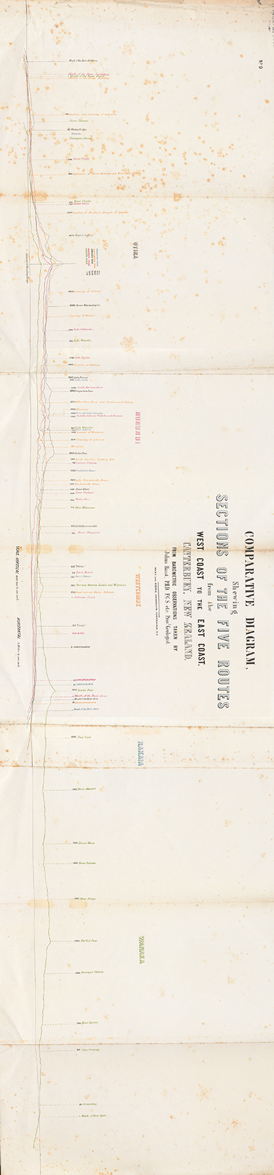
NOTES TO THE COMPARATIVE DIAGRAM.
The annexed Comparative Diagram printed in five colours at the establishment of Messrs. Ward and Reeves in this City, has been prepared to show in one sheet the characteristic features of each route from the East to the West Coasts of this Province, without compelling the reader to examine separately the five altitude sections prepared by me.
It will be observed that I have fixed upon the highest point reached by each route on crossing the central chain, as a starting point to both coasts, as by so doing, not only the distance of that particular point from the East and the West Coasts is clearly shown, but also the comparative length of road to be traversed. as well as their principal characteristics compared one with another.
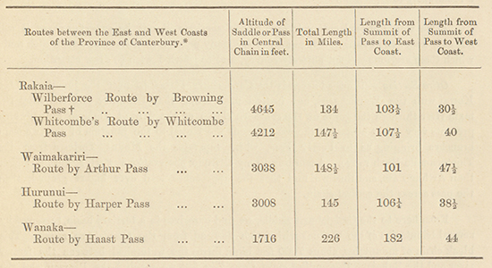
In the following table I have given all the principal numerical statistics of these different routes, namely, their total length, and the distance from the summit of the passes to the East and the West Coasts, which, for comparison, is not without interest.
* These distances have been measured on the Map of the Province, and as they pass very often over ground which has only been sketched in, it is almost needless to say that they are only fair approximations. Since these sections were constructed by me the road by Arthur Pass, from Christchurch to the mouth of the Arahura, has been carefully levelled and measured by the Public Works Department, with the following result:--
Altitude of Pass in Central Chain... ... 3013 feet.
Total Length... ... ... ... 141 miles 78 chains.
Length from Summit of Pass to the East Coast 94 miles 6 chains.
Length from Summit of Pass to the West Coast 47 miles 72 chains.
t Two good sets of observations obtained during my last journey on March 31, 1806, gives a somewhat different result for this, the highest available pass in the Province, namely, 4752 feet, or 105 feet higher then the altitude calculated from a single observation in November, 1865. I think that the result obtained at the latest date claims more correctness, for not only had I a double set of observations, taken during fine weather, at the regular hours observed at the Christchurch Meteorological Station, but I had also the advantage of a further check for my calculations, by taking into account the observations taken at the Hokitika Meteorological Station which did not exist when I travelled over this pass in the beginning of last spring.
[Image of page 64]
The shortest route to the West Coast is therefore by the Rakaia and Wilberforce, over Browning Pass, thence down the Arahura and Styx Rivers to Hokitika; this is only 134 miles, whilst the longest is that which starts from the East Coast, near Arowhenua, and passes by Lake Wanaka, across Haast Pass, and measures 226 miles. But the routes by Arthur and Harper Passes will always be preferred by travellers, as they are seldom obstructed by snow, and are not subject to avalanches.
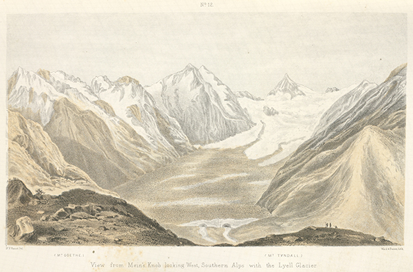
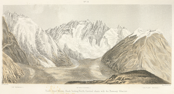
A glance at the different sections, and the preceding table, will show at once that the western slopes of the central chain are by far the steepest, and of course the shortest; thus the section by Whitcombe Pass which follows the beds of the most important rivers of each coast, namely, the Rakaia on the eastern, and the Hokitika on the western slopes of our Alps, gives us a clear insight into the fall of both rivers, and shows the remarkable difference between the length of their course and their gradient. Thus whilst the Rakaia, which is 85 miles long, has an average fall of only 39 1/2 feet per mile from the Ramsay Glacier, its source, to the sea; the Hokitika, 40 miles long, has from the Sale Glacier to the West Coast, a fall of 104 1/2 feet in the mile; this difference is still more remarkable if we compare the course of the Waitaki, which is 117 miles in length, from the terminal face of the great Tasman Glacier (2772 feet), and is the longest and largest river of our Province, with the opposite Waiau River which is only 12 miles from the terminal face of the Francis Joseph Glacier, (708 feet) this gives 23 3/4 feet fall for the eastern, and 57 1/2 feet for the western river. The latter would have of course a much greater fall, considering the close proximity of the summit of the central chain to the coast, did not the Francis Joseph Glacier descend to such a remarkably low position.
A few words of explanation to each line of section will not he superfluous, as it will not only assist the examination, but there are many peculiar physical features in each route which these sections can not entirely convey, and to which I wish to draw attention.
Otira Section.--The road ascends the Canterbury Plains to near the junction of the Kowai with the Waimakariri, but instead of crossing that tributary and following the main river through the gorge on the southern slopes of the Mount Torlesse range, which presents very great obstacles, the road ascends the Kowai to the junction of the two main branches bringing us to Porter Pass, which separates the Mount Torlesse from the Thirteen-mile Bush range. According to my altitude observations Porter Pass is higher than Arthur Pass, and thus we find that the approaches lead over higher ground, than the pass across the central chain.
From here to the Craigieburn saddle, we find ourselves in a tertiary basin, traversed by several tributaries of the Waimakariri, which descend from the Cragieburn range. This bleak chain of mountains, about 7000 feet high, forms the watershed between the former river and the Rakaia. Descending more than 700 feet we reach Lake Pearson and the glacialised country of the Waimakariri, where the hills are remarkably rounded, and large open tracts, now covered by morainic accumulations or alluvium, the former bed of the huge post-pliocene Waimakariri Glacier are traversed.
The road reaches the valley of the Waimakariri after crossing the river Cass, and follows for several miles the slopes of the outrunning spurs on its southern hanks. It afterwards descends into the river-bed and crosses a succession of fans of southern tributaries till opposite the junction of the Bealey, where the road leads across the main river and follows the latter tributary to Arthur Pass.
I have to refer you to page 15 of my Report on the Headwaters of the Rakaia, in which I gave some explanations on the mode of formation of Whitcombe Pass. The same remarks apply equally to Arthur Pass, where remains of moraines going in opposite directions, and the course of the present streams by which the Bealey and Otira rivers are formed, give additional confirmation to such a theory.
[Image of page 65]
I may here draw attention to the peculiarly slight ascent of the Bealey compared with that on the Otira side, which is characteristic of every portion of our central chain. Although in this instance we must not lose sight of the fact that the Otira is a much larger river than the Bealey, and that, consequently, the power to excavate its bed deeper, was so much greater.
After a few miles the gorge-like character of the Otira changes, and wE emerge into a large valley, with all the features peculiar to our shingle rivers, and which leads us into the Large open valley of the Teremakau. Instead of following that river to the ocean, the road, 21 miles above its mouth, once more descends the low western slopes of the central chain, here consisting of great gold-drift, reposing, without doubt, on tertiary beds, and descends again by the Kawhaka creek into the bed of the Arahura, bringing us thus to the West Coast.
I may finally observe that Arthur Pass does not cross the central chain proper, but one of its eastern lateral chains. In a former publication I have already alluded to this fact, namely, that the Teremakau breaks through the geognostic axis of the central chain below the reception of the Otira waters.
Harper Pass, between the headwaters of the Hurunui and Teramakau, is the second pass, which from its low position and easy access recommends itself to our attention. It was the only one in use by the natives of the Province, and was therefore known and traversed for many years.
An excellent dray road brings us to the Waitohi Gorge, where a bridle-track begins and leads across the Waitohi Saddle, 1858 feet high, before we reach the valley of the Hurunui. This saddle, like that over Porter Pass on the Otira route,, could have been avoided by following the main streams from the Hurunui plains, but as the gorge-like character of its bed would have offered such impediments, only to be overcome by very great outlay, this saddle was preferred as a natural road. Even now, when the bridle-track reaches the valley of the Hurunui, it leads along the precipitous sides of the southern ranges, which are remarkably bold and rugged as far as the junction of the southern Hurunui.
The track, when it reaches the lake regions, instead of following the main river to Lake Sumner, ascends the high shingle terrace, and brings us to Lake Taylor, which lies 251 feet higher than the principal lake, and from which we descend by Lake Catherine in one of those remarkable glacier channels into the bed of the Hurunui above its fall into Lake Sumner. This bed has, like all our rivers above the alpine lakes, a straight valley to its source, and in which it meanders in many branches. The road follows this river-bed --beautifully wooded on both sides--to the foot of the pass; an easy ascent of about 300 feet brings us to the summit. Like Arthur Pass, it is on both approaches and on the mountain sides covered with sub-alpine vegetation, whilst the saddle proper is formed by swampy ground, with small water-holes at different levels, and with outlets in opposite directions. The descent into the bed of the Teremakau is far more rapid than the ascent by the waters of the Hurunui.
At the same time the source branches are far more important, and form, after having descended 1500 feet in a few miles, a river much larger than the eastern Hurunui on the opposite side. This western valley has a straight course, and can, even without a road and when the water is not high, be followed with horses to the West Coast, swimming across at a few localities in the gorges below the junction of the Waimea, where the river breaks through the low tertiary ranges.
[Image of page 66]
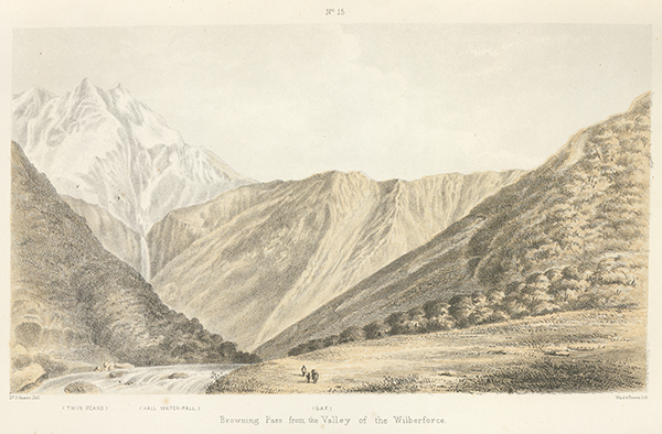
The Rakaia Route, by Browning Pass, does not, with the exception of the pass itself, present any serious difficulties. The road follows the Canterbury plains to the morainic accumulations beginning near the gorge of the Rakaia, now mostly concealed under alluvial beds, to Fighting Hill, when it follows an old course of the Rakaia, across several moraines.
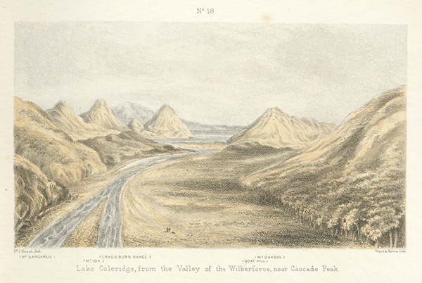
Beaching the terraces of the Acheron, the road descends several hundred feet to the bed of that tributary of the Rakaia, and ascends again considerably till it reaches the moraines lying above Lake Coleridge. A descent of about 100 feet brings us to the southeastern corner of that fine sheet of water, now the head of the lake.
In my section I have followed the old road by the Lake Selfe depression, of which I have given a description, with a geological section in the preceding Report, so that I need not repeat it here.
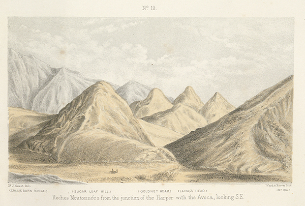
Crossing the Harper a few miles above its junction with the Wilberforce, the road again ascends--crosses the numerous fans which unite the isolated, low ice-worn Scott Hills to the main range, and descends above those roches-moutonnees into the bed of the Wilberforce. Here the road crosses, following afterwards along the base of the Cascade range over good ground to the junction of the Stewart river, which is the principal branch of the Wilberforce.
Having crossed that river (Stewart) we travel by a good track to the southern base of Browning Pass, which rises about 1500 feet steeply above the river: I have described the physical features of this pass in former Reports, to which I beg to refer you.
I was obliged to exaggerate the vertical scale in the sections, as it would have been impossible to show the details of these routes otherwise.
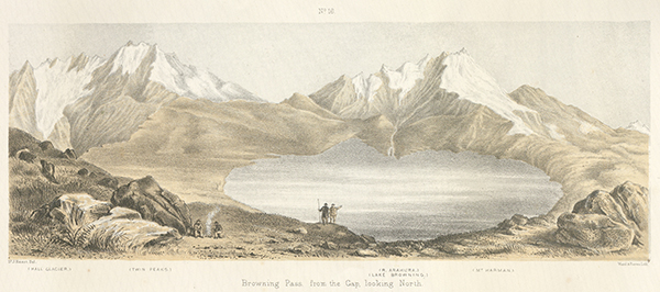
The steep slopes forming Browning Pass look therefore in this section almost vertical, and form a striking feature when compared with the other passes, the slopes of which are of a much easier gradient.
Having ascended the southern face of Browning Pass and crossed the ice-worn hills, of which the summit is formed, we descend by the steep northern slopes into the bed of the Arahura, which, above the junction of the Harman, is so open that the traveller can advance rapidly by crossing and re-crossing; but immediately above that junction, and for several miles below, the river is confined between perpendicular cliffs, often several hundred feet high, which, with little interruption, continue till the river reaches the West Coast plains. The track, therefore, after crossing the Harman stream, leads along the eastern shoulder of Mount Sale instead of following the Arahura, and crosses a low saddle (the so-called Wooded Saddle,) which brings us to the headwaters of the river Styx, one of the source branches of the Hokitika. This stream has a remarkably straight course and brings us into the West Coast plains.
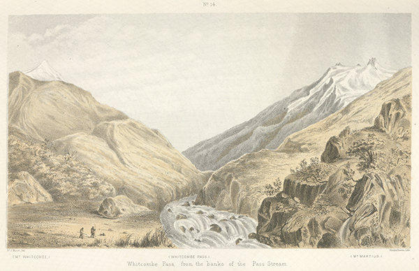
Whitcombe Pass is another interesting pass, coloured yellow in the Comparative Diagram. The road to it, so far as the south-eastern end of Lake Coleridge, is the same as the Wilberforce road: here it diverges and follows the bank of the Rakaia to above its junction with the Wilberforce.
In the preceding Report on the Headwaters of the Rakaia, I have given all the principal physical features as far as the summit of that pass.
[There was never any Page 67]
[Image of page 68]
For about 10 miles on the western side the road follows the straight shingle valley of the river, which afterwards enters the wooded West Coast ranges, forming a succession of gorges, with rapids and waterfalls.
Jacob Louper, the surviving companion of the late H. Whitcombe, Government Surveyor, has given us a vivid description of this portion of the route, in a Report to the Government; it is partly unknown to me, as I ascended the Hokitika River for only 30 miles from the sea-coast.
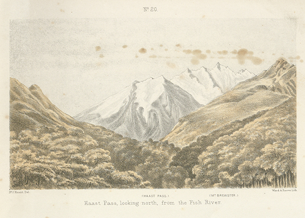
Haast Pass. - There remains only that pass to which my name has been given, situated near the head of Lake Wanaka and which lies remarkably low considering the altitude of the alpine ranges on both sides. On the section I have shown the road I travelled by, which is that generally used by travellers in this Province; by it two passes of greater elevation than the principal pass across the central chain, have to be crossed, namely, Burke Pass, leading from the headwaters of the Opihi into the Mackenzie Plains, or upper valley of the Waitaki; and thence by Lindis Passinto the valley of the Molyneux. Both could of course be avoided by following along the valley of that latter important river, but as my object was principally to show the comparative value of each route to the Province of Canterbury, I could not abandon the direct road leading to Lake Wanaka. My section shows the road which crosses these two passes leading thence to Lake Wanaka, and along the shores of that lake to Messrs. Stewart and Kinross's station. From there by water to the head of the lake, as there is much difficulty in travelling with horses along the shores of the upper portion of the lake, the country being very rough in places. From there to Haast Pass the road follows the valley of the Makarora and its tributaries by a very easy gradient, and then falls more rapidly for about 10 miles to the junction of the Burke with the Haast, when again the natural fall of the valley to the sea offers a remarkably fine highway between the two coasts,
[Image of page 69]
APPENDIX NO. II.
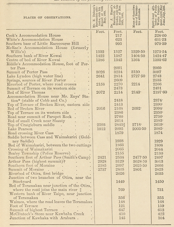
Since the Comparative Diagram was prepared, and the observations contained in Appendix I. written, I have, through the courtesy of the Provincial Engineer, obtained possession of the results of the spirit-level survey of the whole Otira road, which, besides their high intrinsic value, are personally of the very greatest interest to me. Not only is a very perfect altitude section of that important road thus presented to us, but it gives me a welcome opportunity to check my own barometric observations. Whilst doing so I remembered that already Mr. E. Dobsom, our Provincial Engineer, had published about six months previously a set of similar barometric observations, which, when compared altogether with those obtained by that more reliable method, the spirit-level, would certainly offer us some curious and instructive data.
These altitudes obtained by the Public Works Department may, of course, be relied upon, as they have been twice checked, and the difference found to be only a few inches.
Mr. Dobson has kindly allowed me to publish these spirit-level altitudes, which I do the more readily as it gives me an opportunity to compare, in the annexed table, not only the barometric altitudes, one set with the other, but also with the spirit-level results.
It will be observed that in many instances where altitudes of both observers are given, the mean of these barometric observations agree closely with the spirit-level result.
It must at the same time be borne in mind that these first observations were taken in two different seasons, namely, in autumn and spring, where very often different atmospheric conditions exist.
Thus whilst Mr. Dobson's results are generally too low, mine are too high, for which besides the above-mentioned causes, a different method of calculation may account.
To obtain for comparison still more reliable results, I shall calculate the two sets of barometric observations after the same method, and give the particulars in a future publication, together with some notes on the causes which have affected the reading of the instruments on each occasion.
There is no doubt that the difference existing in the state of the atmosphere at the Meteorological Station on the sea-coast, and at the same time on or near the summit of the alpine passes in the interior, has greatly influenced the readings of the instrments.
[Image of page 70]
TABLE OF ALTITUDES OF THE ROAD BY ARTHUR PASS ACROSS THE PROVINCE OF CANTERBUY, N. Z.,
As obtained by the following observers.
* In my Report this position was erronously set down at 2548 feet above the sea, which is the true altitude of Mr. Enys' homestead, which lies close to the accommodation house.
† Instead of taking for the mean the altitude given in my Report, viz., 3088 feet, which as note 8 explains, is a combination of the spirit-level results with the barometrical observation taken at Smith's Camp, I here state only the result of my barometrical observations, which, owing to the unfavourable state of the weather, was 91 feet higher, in order to obtain a fair mean result of the barometrical readings of the two observers.
‡ Result of Mr. J. Rochfort, calculated from barometrical observations for the junction of Otira with Teramakau.
§ Without doubt an error in the readings, as the observations on both sides, taken an hour before and afterwards, agree very closely with the spirit-level.
[Image of page 71]
This Table shows thus once more convincingly that although mathematical correctness cannot be claimed for altitudes calculated from barometric observations, they are nevertheless sufficiently accurate for all practical purposes. And every observer must rejoice that even single observations, when carefully taken, possess more intrinsic value than is generally allowed to them,
CHRISTCHURCH:
PRINTED UNDER THE AUTHORITY OF THE PROVINCIAL GOVERNMENT OF THE PROVINCE OF CANTERBURY, AT THE 'PRESS' OFFICE CASHEL STREET, BY JAMES EDWARD FITZGERALD, PRINTER FOR THE TIME BEING TO THE SAID GOVERNMENT.
[Image of page 72]
APPENDIX No. 3.
THE printing of the Sections and Views belonging to this Report having been unavoidably delayed by the Lithographers, I am enabled to append a copy of my Topographical Map of the Headwaters of the Rakaia, prepared by me in the meantime. An insight into the remarkable orographical features of this portion of the Southern Alps, with their snow fields and glaciers, will be thus conveyed to the reader much more easily than by any written description, however elaborate.
Having at the same time marked on the map the lines of my journey, and of the Geological Sections, I trust that the description of the country traversed by me can not only be followed with greater facility, but also that my geological explanations will be more easily understood, than if these particulars were omitted.
JULIUS HAAST.
Geological Survey Office,
Christchurch, N. Z., April 15, 1867.
[Image of page 73]
[Page 73 is blank]
[Image of page 74]
[Image of page 75]
[Image of page 76]
[Image of page 77]
[Image of page 78]
[Image of page 79]
[Image of page 80]
[Image of page 81]
[Image of page 82]
[Back cover]