CHAPTER II.
[Image of page 19]
CHAPTER II.
THE Pah of Kaiapohia was originally built by Tu Rakautahi, about the year 1700, after the expulsion from the district of the Ngatimamoe. Tu Rakautahi was the head chief of the tribe known as Ngatikuri, or Ngai Tahu, a tribe which first settled in the neighbourhood of Poverty Bay on its arrival from Hawaiki in the canoes, Taki-timu, Kara-haupo, and Mata-horua. It afterwards removed to the shores of Cook's Strait, and fixed its chief settlement near Evans' Bay, in Port Nicholson. From there it migrated, in 1677, to Queen Charlotte's Sound, and commenced at once a war of extermination against the Ngatimomoe, a tribe which about a hundred years previously had crossed over from the North and destroyed the Waitaha, who were the first Maori occupants of the South Island. The Waitaha came originally from Hawaiki, in the canoe Arawa, and gradually made their way south from the Bay of Plenty, and crossed Cook's Strait about the year 1570. Freed from the alarms of war, and nourished by the exhaustless supplies of food furnished by a region where the finest sorts of fern-root and choicest ti palms grew, and field rats, and wekas swarmed in the open country, where the
[Unpaginated illustration]
[Image of page 20]
woods were full of kakas, pigeons, and other birds of all kinds suitable for food, where the lakes and rivers were covered with water-fowl, and teemed with eels, and silveries, and whitebait, where along the sea coast shell fish, seals, mutton birds and fish of every sort were obtainable, the Waitaha increased and multiplied so rapidly, that they are described in the ancient traditions as "covering the face of the country like myriads of ants."
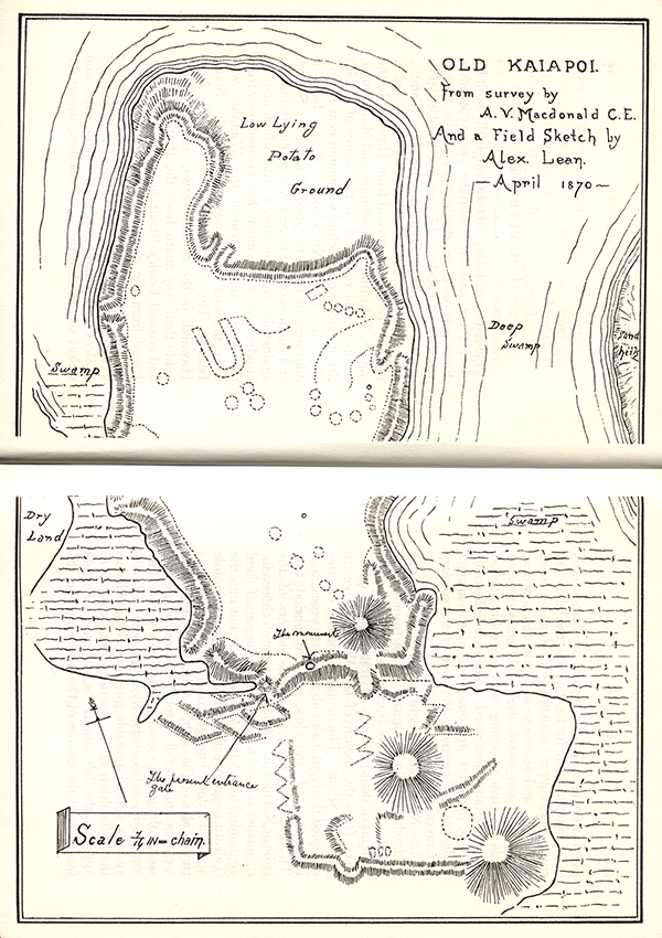
The Ngai Tahu fought their way under the leadership of Tu Rakautahi's sons from Queen Charlotte's Sound to Stewart's Island, and the remains of their pahs may be traced all along the coast from the mouth of the Wairau River to Foveaux Strait. The conquest of the country occupied the Ngai Tahu about thirty years; and it was towards the close of that period that Tu Rakautahi fixed the head-quarters of the tribe at Kaiapohia. The site was well chosen for defensive purposes on a small tongue of land containing about five acres, jutting out into the Tairutu Lagoon, a sheet of water of considerable size, and deep enough to afford protection on three sides of the Pah. Adjoining the lagoon were swamps which stretched away north and south along the coast and for many miles up the plain in a westerly direction. These swamps served a double purpose: they added to the difficulties of a hostile force trying to approach the Pah, and at the same time afforded facilities for the escape of the inhabitants, in the
[Image of page 21]
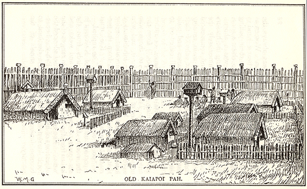
event of its being captured by enemies. The fortifications consisted of earth-works, surmounted by strong palisades. The defences on the land side were strengthened by a broad, deep ditch, which extended across the entire front of the Pah. Behind the wall of earth there was a double row of strong palisades, eighteen to twenty feet high, bound at the top and bottom to cross ties with a tough kind of woodbine called Aka. The cross ties were fastened to large totara posts, erected at intervals along the wall; and on the top of each post was carved a grotesque figure, inlaid with pearl shell, and painted with red ochre. The walls were pierced by three openings, two on the land side, and one on the western side adjoining the lagoon, which was connected with the opposite shore by a bridge. The Pah was considered so impregnable, that it became a proverbial saying in allusion to it, "who can scale the inaccessible cliff of God." The space within the walls nearest to the gates, Kaitangata and Huirapa, was occupied by the houses of some of the principal chiefs. They were all built facing the north, and were large structures capable of accommodating a hundred persons, and some of them even a greater number. They were ornamented both inside and out with carving and scroll work. Close beside each of these dwelling houses stood the Kauta or Kitchen, and the Whata or Storehouse belonging to it. The rest of the space was
[Image of page 22]
mostly occupied by the houses of the commonality, who formed the majority of the population. There were two burial grounds within the Pah; and a large open space between the gates Hiakarere and Huirapa, where public meetings and sports were held. At the north end of this space stood the large Whata erected by Tamati Tikao's father, and called the Matuku rangi. The stump of the large totara post which supported the Whata is still visible. The "Tuahu," or shrine of the guardian Atua, was placed at the northern corner of the fortress, in the safest and most secluded spot, and the house of the Ariki, or chief priest, adjoined it.
The timber required for the construction of the Pah was procured from the neighbouring forests, which covered the greater part of what is now known as the Maori Reserve, and extended from Woodend to Rangiora. The trees were cut down with stone axes, a long and tedious operation where they were of any size, and wooden wedges were employed to split them up when slabs were required for house building. These materials were conveyed to the place where they were to be used either on mens' shoulders or they were dragged along the ground with ropes, skids being placed underneath to lessen the friction. When timbers had to be hauled from the forest, a general invitation was given to the people by the Chiefs in charge of the work to come and assist them: an invitation which was always readily responded
[Image of page 23]
to, as the business of hauling was always the occasion of much feasting and fun. Women as well as men were welcome to bear a hand in pulling the ropes; and to ensure their pulling together, one man was told off to chant a song, to each verse of which there was a chorus. While the solo part was being sung the haulers rested and took breath, but immediately the chorus began they joined in it and commenced to pull with all their might and main, causing the woods to ring again with the echo of their loud song. With successive pauses and pulls they proceeded on their way till called off to rest and feast.
The Pah got its name Kaiapoi, or rather Kaiapohia, (meaning "food depot,") from the answer given by Turakautahi to those who criticised his choice of the site for it, and who asked him how he expected the inhabitants of a place so situated to escape starvation, seeing that they were too far removed from the permanent sources of food supply. "'Kai' must be 'poi'" or swung to the spot," he replied,-- "potted birds from the forests of Kaikoura in the north, fish, and mutton birds from the sea-coasts of the south, Kiore and weka and kauru from the plains and mountain ranges of the west." The ready wit of the Chief silenced the objections of his critics, and his Pah was henceforth known as Kaiapoi, a name destined to become famous in the future annals of the country.
[Unpaginated illustration]
[Image of page 24]
In order to provide themselves with the means of exchange for the commodities they stood in need of, the inhabitants of Kaiapoi were obliged to devote much of their time to the cultivation of the Kumera, or sweet potato, and to the preparation of Kauru or cabbage tree stems, which they bartered with the inhabitants of other parts of the island for whatever else in the shape of food they stood in need of. The Kumera being a native of a tropical climate they found great difficulty in growing it so far south, where frost was likely to prove fatal to its existence. To regulate the temperature of the soil, and to secure perfect drainage, they covered the surface of the Kumera plantations with fine gravel, to a depth of six inches, which was afterwards formed into mounds about two feet in diameter, and arranged over the field with the precision of the squares on a chess board, and in these mounds the Kumera tubers were planted. Breakwinds of manuka branches, varying from two to four feet in height, were erected every few yards apart, and in such a way as to secure the largest amount of sunshine and shelter to each plant. Both the planting and gathering of this crop were attended with peculiar religious rites, and only skilled persons were allowed to take any part in a work, every detail of which was held sacred, and conducted under the supervision of officers, chosen for their special qualifications at the annual meeting of Tohungas or learned men, held in the Whare Purakaunui
[Image of page 25]
on the rising of the star Puaka (Rigel). It was the duty of these officers to consecrate the Kumera plantations each spring to the service of Marihaka and Pani, the two divinities who presided over the welfare of the sacred plant. Starting from the left-hand corner of each field, they began this ceremony by placing sprigs of koromiko or veronica in the ground; after doing this, they walked in a straight line to the other side of the field, reciting together as they went the appropriate prayers. At the top of each mara or plot they gathered a handful of leaves or weeds (pitau), which they carried in their hands to the nearest Taumatua, or shrine. There were two of these shrines at Kaiapoi, one being situated at Waituere, nearly opposite Mr. Charles Young's present residence, and the other near the Maori village of S. Stephen's, in the centre of the reserve. They each consisted of a small piece of ground a few feet square, enclosed with a fence like a grave plot: within the enclosure, which was called "the god's garden," four mounds were made and planted with kumeras. After consecrating the left side of the fields, the officials proceeded to consecrate the right side, gathering as before the pitau offering, which was duly placed in one or other of the shrines, and called the Whangainga, or feeding of the Atuas. The last persons who performed these important duties at Kaiapoi were Te Auta, Te Whaketu, Tina, Takatakau and Karara; these were all old and venerated
[Image of page 26]
chiefs. Their youthful coadjutors were Takai, Popowai, and Tikapakapa. The pits and gravel-strewn surfaces in the Woodend district, which have puzzled the English settlers there to account for, remain to remind this generation that Canterbury once included amongst its vegetable products a tropical plant which is now extinct, but the cultivation of which for many generations occupied much of the time and thought of the former inhabitants of the country. The storing of the kumera had to be conducted with the utmost care, as the slightest bruise, or even abrasion of the skin, caused the immediate decay of the tuber. The kauru was prepared in the summer months from the cabbage palms, which grew in great profusion on the upper parts of the plain. Young trees, about five feet high, were selected. The stems were cut into two feet lengths, and stripped of the bark and woody substance which covers the fibrous core, the only part of which was valued as food. These were tied in bundles and stacked, till a sufficient quantity had been obtained, when an oblong pit was dug, varying in size from four to twelve feet in length, and about five or six in depth. A quantity of stones were placed in the bottom, and firewood piled upon them which was afterwards lit, and when consumed, the pit was filled in with the prepared ti palm stems, which were covered with matting and soil. A quantity of water was then procured in buckets formed with flax
[Unpaginated illustration]
[Image of page 27]
leaves, and poured into the pit, the bottom of which was covered with the heated stones. The steam generated was prevented from escaping by a sufficient quantity of soil being heaped upon the mat-covering of the pit. After several hours the oven was uncovered and the kauru was found to be cooked sufficiently for use. It was then placed in flax baskets and carried to the store-houses in the Pah. When required for food the fibre was either chewed for the extraction of the saccharine matter it contained; or it was pounded and mixed with water in a wooden dish till it assumed the consistency of thin gruel, when it was ready for use, being conveyed to the mouths of those who partook of it either with a mussel-shell spoon or a sop of fern root; or, wanting these, with the first two fingers of the right hand.
The trade created by the system of food exchange established by Tu Rakautahi, necessitated the employment of a large body of porters, who were constantly employed carrying heavy loads to and from the various Pahs extending from the north to the south of the island. The labours of these men were greatly increased by the practice which prevailed of giving each of them more than one load to carry. This necessitated the formation of depots, between which the carriers went backwards and forwards, travelling over the same ground again and again, until they reached
[Image of page 28]
their final destination. The weight of an ordinary load was seldom short of a hundred pounds, attached to the lower end of each burden was a sort of stool, to enable the porter to rest at any time during the journey, without the trouble of disengaging himself from his load. When a band of porters were returning home, and had reached the last stage, they sent forward one of their number to inform the person to whom their burdens were consigned of their arrival. Whereupon he gathered a number of his friends and dependents together, and went to meet the carriers; and on reaching the place where they were awaiting him, he directed the extra loads to be taken up by those who had accompanied him, and then the whole party started in procession for the Pah, where on entry, they were greeted with loud acclamations of welcome.
The population of Kaiapoi was considerable for a Maori town and, very aristocratic, as most of the chief families of Ngai Tahu had their head-quarters there, and owned what we should call a family mansion. In peaceful times the inhabitants were dispersed over the country from Waipara to Ashburton, and from the western ranges to Banks' Peninsula, fishing, hunting, or cultivating the land. They either dwelt during such periods in partially fortified Pahs like those, the remains of which may be seen near S. Stephen's Church, on the Maori Reserve, or in open Kaingas, consisting of a few unprotected whares.
[Image of page 29]
As time went on the inhabitants of Kaiapoi acquired a wide-spread reputation for wealth. In addition to the spoils of the vanquished Ngatimamoe, they were known to possess a large quantity of the highly-prized greenstone, which they had obtained from the West Coast; and many covetous eyes in the North Island were fixed upon their valuable possessions. Every tribe throughout Maoridom prized greenstone above everything else, and strove to acquire it. The locality in which it was found was known by report to all, and the popular imagination pictured untold wealth to be awaiting the adventurous explorer of that region. But the difficulties which beset the journey to this Maori Eldorado were practically insurmountable, and frustrated the efforts of most of those who attempted to reach it. The stormy straits of Raukawa had first to be crossed, and then a land journey of great length and difficulty undertaken, over rugged and lofty mountain ranges, so steep in places that the travellers were obliged to use ladders formed of supple jack, or other tough woodbines, to enable them to get past. Pathless and seemingly interminable forests had to be traversed, whose dark shades were made still more gloomy by the incessant rainfall, which kept the thick undergrowth of moss and ferns always dripping wet. Deep and rapid rivers had to be crossed, either on rafts made of dried flax stalks, or on foot, the waders being only able to avoid being
[Image of page 30]
swept away by the swift current, by a number of them entering the water together, and holding on tightly to a pole which they bore across the river in their hands. The scarcity of food throughout the whole region to be traversed by the searcher after greenstone, added to the danger of the task, for beyond the small quantity they were able to carry with them travellers were entirely dependent for their food upon the wekas and eels, which they were able to catch as they went along. But besides all these difficulties they were in constant danger of encountering hostile bands of men, bound on the same errand as themselves. But even where the journey was so far successful that the treasure sought for was found, its great weight made it impossible for the discoverer to carry back more than a few fragments, and these were obtained by breaking them off with stone hammers. In spite of the longing desire of the northern Maoris to enrich themselves with the treasures of greenstone which existed on the west coast of the South Island, the serious obstacles which beset the approach to that region deterred them from making the attempt to get there, and they had to content themselves with what they were able to acquire from their fellow countrymen in the south, in exchange for mats and canoes, and such other manufactures as their southern neighbours were willing to accept.
[Image of page 31]
In spite, however, of the drawbacks and difficulties attending the acquisition of greenstone, there were very few Maoris in either island who did not possess some tool, or weapon, or ornament formed of it. And the story of the way in which the Maoris overcame the difficulties which beset the finding of the greenstone, and its conveyance on their backs across the Alpine ranges to their distant homes, and the manufacture of its hard material into useful and ornamental objects, will remain a lasting monument of their enterprise, energy and industry.
According to an ancient legend the reason why greenstone is found in such an inaccessible region is that the locality was chosen by the three wives of Tamatea the circumnavigator, when they deserted him, as the hiding place most likely to escape discovery. Tamatea's search along the east coast was unsuccessful, and after passing through Foveaux Straits he continued to skirt the shore, listening at the entrance to every inlet for any sound which might indicate the whereabouts of the runaways. But it was not till he arrived off the mouth of the Arahura river that he heard voices. There he landed, but failed to find his wives, being unable to recognise them in the enchanted blocks of greenstone, over which the water murmured incessantly. He did not know that the canoe in which his wives escaped
[Image of page 32]
from him had capsized at Arahura, and that its occupants had been changed into stone, and so he passed them by, and continued his fruitless quest.