APPENDIX.
[Image of page 77]
APPENDIX.
[Image of page 78]
APPENDIX.
[Inserted unpaginated illustration]
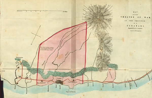
Reference to General Map of the Theatre of War.
From the Waitara to the Town is about 10 miles; thence to Warea, 25; thence to Patea, the boundary of the Province, 60 miles, which is within 30 miles of Wanganui.
The amount of land owned by the white population is about 74,000 acres, with a coast line of about 12 miles. That owned by the Maories is about 2,300,000 acres, with a coast line of about 116 miles. One-sixth of the country is open land; the remainder being clothed with scrub or forest. The belt of green on the map is only intended to convey the approximate distance of the bush from the coast, the bush itself uninterruptedly extending as far back as the mountain. That coloured pink shews the land that has been purchased at various times by the Government.
The Town and the various Stockades are marked with black: -- No. 1 being the Waitara Camp; No. 2, Ngapuketurua, near Mahoetahi; No. 3, Onukukaitra, near Puketakauere; No. 4, Matarikoriko.
Notwithstanding that the country around Taranaki is much broken, there are some large level plots of bush land, requiring only the energetic use of the axe to make it available towards supporting a large and industrious population.
[Image of page 79]
By means of the telegraphic system introduced by Sergeant Marjouram, R. A., signal communication has been arranged from the Waitara Camp to Onukukaitra; thence to Ngapuketurua, by the Bell Block, to town. During the period which Major Hutchins held the camp at the Waireka, communication with the Town was made via the Omata Stockade.
[Inserted unpaginated illustration]
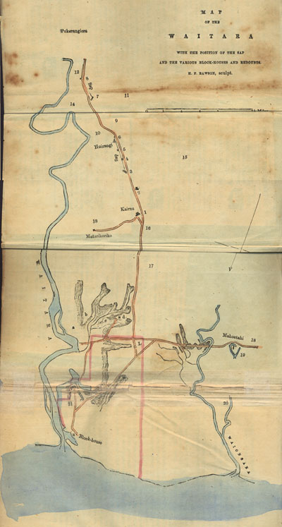
Reference to Map of the Waitara.
Mr F. A. Carrington, in a pamphlet entitled "The Land Question of Taranaki," thus remarks on the Waitara, "The locality of the Waitara is second to no other part of New Zealand; --the ground on each side of the river, near its embouchure, if in the hands of civilised men, would quickly become very valuable; it has the advantage of a small craft tidal harbour, with a sufficient depth of water for coasters and traders from the adjoining colonies; the climate is salubrious, and the soil on each side of the river, for many miles along the coast and inland, is very fertile; and as it presents an admirable site for building, there cannot be any reasonable doubt but that, in a very short time, a town would spring up of considerable importance in commerce and revenue."
The Waitara district comprehends the country between the Mangoraka and Waitara rivers. The country generally may be described as flat table land, intersected with innumerable fissures and gullies, covered with a luxuriant growth of high fern, with here and there small copses of the beautiful green karaka bush; the table land either ending in a gradual slope towards that immediately adjoining the river, or in steep, and, at places, almost perpendicular cliffs. The whole of this country bears evidence of recent formation. In most of the redoubts wells were sunk for the purpose of obtaining a supply of water for the garrisons; invariably, at the depth of between twenty and thirty feet, large masses of timber were met with, not far advanced in decay; the water was scarcely fitted for general use, it being impregnated with ferruginous and decomposing vegetable matter.
The colours on the map denote--Blue, the rivers and ocean boundary; light red, the roads; pink, boundary of the land in dispute.
[Image of page 80]
1. Kairau, or No. 1 Redoubt, was thrown up by by the General in his gradual advance towards Huirangi. Near this spot the pa stood which was destroyed on the 11th September, 1860. Ngataiparirua, situated about half-a-mile on the road nearer the coast, fell at the same time. Matarikoriko is situated upon a hill about a mile from Kairau. To the rear of this naturally strong position was a spur, with a steep inclination towards the swampy and scrub-entangled river flats. The Maori fortification was flanked on the right by gullies heavily timbered, and to the left front by a deep swamp and fern gullies. The road from Kairau was through bush and very high fern; whilst some little distance to the right was a deep swamp. The country around Matarikoriko is somewhat similar to that as shown surrounding Puketakauere. On Monday, December 31st, the hill was occupied by a party of the 65th and some blue-jackets, under the command of Lieut.-Colonel Wyatt. The old fortifications were destroyed and a blockhouse erected.
2. A small guard redoubt, from which the long 9-pounder gun threw shell into the Maories' reserve on the left front when they so boldly attacked No. 3 Redoubt.
3. A three-square redoubt, in echelon, left in front. The attack made on this redoubt on the morning of the 23rd January, 1861, was chiefly directed towards the extreme left; the reserve being stationed somewhat more towards the front, so as to be enabled to take advantage of the gullies and inclining banks that slope towards the river. Whilst the 65th were enfilading the ditches on the right, the reserve was effectually routed by the gallant charge of the 12th, under the command of Lieut. Lowry -- Captain Miller, whilst preparing for the charge, receiving a bullet through his leg. From this redoubt a double sap was run.
4 and 5. Guard redoubts, for protection of works.
6. Large square redoubt, with flanking angles, near the Huirangi Avenue --a beautiful spot, much resorted to in former days by riding parties. The distance from Kairau tO No. 2 is 570 yards; to No. 3, 430 yards; from No. 3 to No. 6, at the end of double sap, 770 yards; from No. 6 a single sap was continued 86 yards further, passing through the first line of rifle pits, which extended from No. 10 to
[Image of page 81]
No, 15.
7. Large redoubt; on table land, after passing the bush in the neighbourhood of the Avenue. To the right, near the spot marked 11, Captain Strange, of the 65th, was mortally wounded, whilst in charge of the skirmishing party. A single sap was continued from the redoubt towards Pukerangiora. The line of bush passes from the hills immediately in front of No. 7 to Huirangi.
8. Square guard redoubt, thrown up to protect the sap after the rollers had been removed during the night by the Maories, and a considerable amount of damage effected by throwing down the gabions. From No. 8 a deep double sap continued its course, passing through several lines of rifle-pits.
9. Bush near the Avenue, from which the 40th soldier was shot on the 11th September, and his body carried away.
10. Rifle-pits, with a Maori graveyard on a hillock a short, distance in the rear, by which the second division, consisting of the 40th, under the command of Lieut.-Colonel Leslie, passed on the troops advancing to No. 7.
11. Edge of bush near which Captain Strange was shot, and some time afterwards a large recently covered grave discovered, supposed to contain the bodies of those that met their death on the 93rd of January.
12. Second demi-parallel from double sap beyond No 8, reaching to the nearly perpendicular cliffs of the Waitara, in which Lieutenant McNaughten, of the Royal Artillery, was shot whilst laying the cohorn mortar.
13. Mass of bush, continuing, with an occasional break, to 14.
14. Line of sleep cliffs or banks that pass by (13) Puketakauere on to the Waitara Camp.
15. Line of bush, passing from 11, as shown in the large map.
16. From whence a soldier of the 65th, whilst gathering potatoes, was surprised by the enemy, shot, and carried away, some short period after the occupation of Kairau.
17. Road to the front.
18. Devon line of road from the Waitara to Town.
19. Mahoetahi; stormed on the 6th November, 1869 The cir-
[Image of page 82]
cular lines indicate the swamp by which the hill was surrounded; the black mark representing the blockhouse that has been erected on an adjacent hill (Ngapuketurua.)
20. Mangoraka River, across which the road passes. The course may be traced by reference to the general map.
21. River flat near the Waitara camp, in many places very swampy.
a. Swamp surrounded by tutu, manuka, scrub, and very high fern; to the right of the road is another swamp, with some forest. It was near the swamp (a) that so many of the 40th, with Lieut. Brooke, fell on the 27th of June, 1860.
b. Plateau, from which commanding position the enemy fired with such deadly effect upon the advancing 40th.
c. Puketakauere, a strong Maori fortification, which Major Nelson advanced against on the 27th of June, 1860.
d. Onukukaitara, a hill upon which a blockhouse has been built and signal station erected.
L pa, the first attacked by Colonel Gold, from which King and his adherents effected their escape, after withstanding for many hours a heavy cannonading and continuous fire from the rifles.
The two uncoloured parts in the Waitara River are islands; the lower one is covered at high water. A little below this was the usual anchoring place of the steamer Tasmanian Maid.
[Inserted unpaginated illustration]
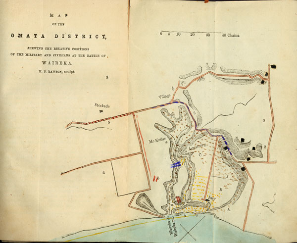
Reference to Map of the Omata District.
The country included within this map is comprehended between the Omata Stockade and the summit of the Waireka hill, which is situated about a quarter of a mile within the English boundary shown on the large map. With few exceptions, the roads lie between compact furze fences, offering excellent cover for an ambuscaded enemy. The whole country around is broken with gullies, heavily timbered and tangled with supplejacks (New Zealand cane) and creepers; the timber disappearing towards the sea-shore.
Passing through the valley of the Waireka (marked 8 on the map), on either side is a thickly wooded copse, from whence, nearly to the summit of the hill marked Pa, are perpendicular banks, left
[Image of page 83]
from the cuttings made to lower the gradient of the hill.
The colours denote the positions of the contending forces at the Battle of Waireka, on March 28th, 1860. Red shows the road taken by the military and small naval force under the command of Lieut.-Colonel Murray; the reserve and rocket-tube being stationed at 6. The red marks on the hill after crossing the stream (c) represent the position taken up by Lieut. Urquhart. Blue denotes the sailors, those near 7 being attached to Lieut.-Colonel Murray's party; Capt. Cracroft's progress is shown by the blue colour that passes the village by 8 to the top of the Waireka hill marked Pa. Brown represents the Maories, spread through the shelter of the wooded gullies, completely surrounding the civil force on the military withdrawing. Black-- Maori pas, or more properly stockades, defended externally and internally by covered rifle-pits. In some places pits had been dug and lightly earthed over, so as to give way when any weight came upon it. The stockade marked Pa is that from which Captain Cracroft took the flag, its rear being protected by another, situated in the bend of the road that wends towards the sea shore. Yellow--the Militia and Volunteers' line of march by the coast, with then positions until retiring on to Jury's house and the hill marked a.
1. Thick furze fence, dividing the paddock which slopes downwards from pa towards Jury's house.
2. Grayling's farm, on which were many rifle-pits.
3. Direction of Ratapihipihi and Burton's Hill, from whence reinforcements of Maories joined in the conflict on the 28th of March. Sixty men were seen by Captain G. R. Burton (Militia), the commanding officer of the Omata garrison, to cross the road near the village and enter the gullies.
4. Steep sand cliff, crowned on the summit with a luxuriant growth of the phormium tenax, or New Zealand flax, up which the Militia and Volunteers fought their way into the open, and were hotly engaged for fully half-an-hour before the arrival of the support.
5. Road by which the military arrived, passing the Omata Stockade.
6. Position of the rocket tube and military reserve. Before retiring Lieut. Urquhart, who was in command of the advanced force, detached
[Image of page 84]
eight of his men, in charge of a corporal, to the civilians' assistance. He did not retire until repeated warnings from the bugle compelled him.
7. Sailors and Volunteers in skirmishing order, where Lieutenant Blake, of the Niger, and Mr Messenger, sen., of the Taranaki Volunteers, were wounded; and P. Fahey, of the Militia, with a marine, shot dead.
8. Steep hill, down which Captain Cracroft led his men prior to rushing the stockade.
9. Rev. H. H. Brown's residence, for which the Militia and Volunteers were bound.
0. Rifle pits on Grayling's farm, when Major Hutchins held the camp on the Waireka.
A. Steep gully, from which the party in Jury's house were much annoyed by the fire of the enemy, who were kept in check by the small force under the command of Captain H. Atkinson (T. V. R.), stationed on the hill marked a.
B. Straw stack, offering shelter to the approaching enemy, near which several Maories were shot.
C. Another straw stack on Armstrong's ground.
a. Captain Atkinson's party, who held this position after the civilians had been left by the military to their fate, prevented, by their active vigilance, the defenders of Jury's house, with their wounded and dead, under the charge of Captains Brown and Stapp, from being outflanked by the Maories.
b. Road near the village inn where the three murdered bodies were found on the 27th of March, the two poor boys not being far distant,
c. Steep gully, with running stream, known as the "sheep-wash," down which the Maories rushed in their endeavour to surround the civilians. On the withdrawal of Lieut.-Colonel Murray's party, several natives were shot by the] civilians as they retired on to Jury's bouse. The civilians retired across this gully in good order, under the cover of the night, by the route that the soldiers arrived.
d. Old native fortification, occupied by the Maories several times during the war, for the purpose of annoying the garrison of the
[Image of page 85]
Stockade.
An examination of the map will give weight to the words afterwards made use of by Captain Stapp, who stated that, from the peculiar structure of the country, he was compelled either to fight or to turn round and run away. Both he and his men had preferred the former.
On leaving the town prior to the Battle of Waireka, the Militia and Volunteers were directed to pass round the rear of the enemy's position and to proceed to Mr Brown's (marked 9); whilst the support was to have awaited at the Whaler's Gate, about half-a-mile nearer the town than the Omata Stockade. The whole affair appears to have been proceeded with regardless of the slightest thought or foresight. Was it at all likely that the natives, with their barbarous and savage feelings excited to the utmost by their war dance and recent murders, would allow a very inferior force to pass close within sight without disputing their progress? Had a combined attack been skilfully planned, nearly every Maori might have fallen into our hands, and the murderers either have fallen by the casualties of battle or been taken prisoners; and thus have relieved the Government of the most difficult task connected with their pending negociations. The force, with the addition of a 24-pounder howitzer and Captain Cracroft's party, would have amply sufficed. The artillery might have scoured the gullies with case and canister; a small support could have followed Captain Cracroft, and another the Militia and Volunteers; the latter force, by extending their right, could have taken the natives in the rear and have been enabled to effectually carry out the object for which they left-town; and there, probably, the war would have ended. So passive were those in power, that even the next day the natives were allowed to stay until two o'clock in the afternoon, and then quietly retire to their own homes, with carts laden with plunder, unnoticed and unpursued.
Explanation of Illustrations on the Cover.
No. 1. View of Mount Egmont and Barracks from the Town. The mountain rises in a perfect cone, from a base of about 30 miles in diameter, to a height of 8, 270 feet above the level of the sea.
[Image of page 86]
From the. Town it bears 51 deg. 12 min. W. (true), 14.45 miles.
No. 2. View of the mountain and ranges from the Omata,
No. 3. The Sugar Loaves, which are situated 174 deg. 4 min. 58 sec. N. E. (true), about two and a half miles from the Town, in a conspicuous position, so as effectually to point out the whereabouts of the roadstead. The sea-coast road to Omata passes from the beach over the sand hills by Paritutu, or main Sugar Loaf, to the beach again. Paritutu rises for 400 feet abruptly from amidst the sand hills on the main land, whilst the others are islands surrounded with water.
No. 4. View of the Waiwakaiho River and Bridge, situated on the Waitara road, about a mile and a half from the Town. The bridge is a finished piece of workmanship, crossing the river in a span of 120 feet. It is constructed of the enduring puriri, or New Zealand ironwood.
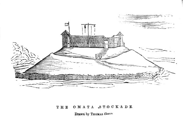
Omata Stockade, or, more properly, Blockhouse.
In a description of this outpost something is due to the settlers of the district, who, at a time when so much excitement prevailed, determined to make a stand there in defence of their homes and families. In common justice, it ought also to be stated that, in the erection of the Omata Blockhouse, there was no military assistance or advice in the selection of the site, nor were those so deeply interested in its erection supplied with any plan for their guidance by the military engineers. It is true that the internal comfort of the building is solely due to Captain G. R. Burton, of the Taranaki Militia; but, without doubt, to Mr Good, formerly of Omata, belongs the credit of planning and executing the fortification. He was oftentimes to be seen working alone, before others could be induced to join in the active furtherance of its completion, to the present time sacrificing time and means in a public work without reward or acknowledgment from the Government. The blockhouse can comfortably accommodate 60 men. It is built of rough-hewn timber, 1 1/2 to 2 feet in diameter, split in two, slabbed on the inside to render it ball-proof. The ditch surrounding is 10 feet in depth, having a perpendicular wall on the far side, crossed by a drawbridge from the outside--the
[Image of page 87]
only approach to the building, which is square, and commanded by two flanking towers, situated at opposite angles.
Omata is between three and four miles from the Town of New Plymouth. There is no longer a house standing of this once pretty village. It was there those horrible murders were perpetrated at the commencement of the war; and as there is still £100 reward for the apprehension of any one of the murderers, it may not be considered out of place here to enumerate the names of those principally concerned:--
The two boys, Pote and Parker, are said to have been killed by Ihaka te Aka, Tahuna, Karira, and Rihara; Ford--Perere, Rihari, and Haneti; Shaw and Passmore--Minarapa and others.
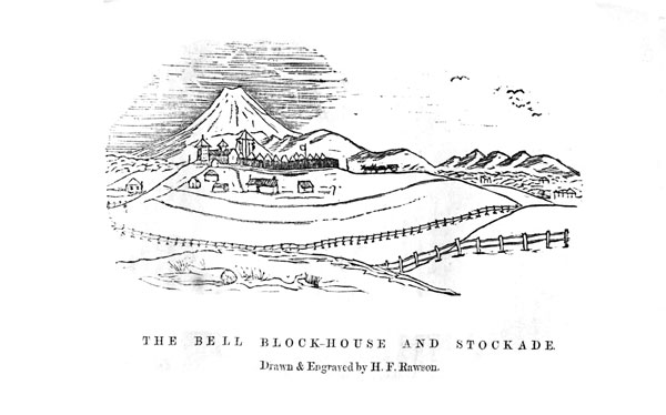
Bell Blockhouse.
This fort was erected by the settlers of the district for the purpose of shelter and self-protection. On the proclamation of Martial Law, March 5th, 1860, a public meeting was called for the purpose of discussing the position in which the colonists were likely to be placed by the coming hostilities, and to devise some plan for the purpose of mutual protection. A committee was appointed, and, after much deliberation, the plan of the present blockhouse was submitted and approved. It occupies a commanding position, and presents an impregnable fort to any enemy devoid of artillery. Its length is 62 feet; width, 22 feet; height, 11 feet. A ditch surrounds the fort, enfiladed by two towers, 22 feet high, at its opposite angles. These towers are 11 feet square, and, similarly to the body of the building, judiciously loopholed, and rendered musket and ball proof.
To prepare the material and build this blockhouse were subjects which occupied the most earnest and serious attention of the committee. The resolution of the 72 men who dwelt in the district was unflinching; and, in a short time, upwards of 100 loads of timber were felled, split, and carted to the spot, everyone being in readiness to give their labour towards the completion of the undertaking. At this juncture the military authorities sent a positive order that the building was not to be proceeded with; that there was no immediate danger; and a proclamation was posted which guaranteed to the settlers ample time and notice to remove themselves and their effects.
[Image of page 88]
This notice was posted, but wide latitude was given for all to to act for themselves. In the meantime the Militia and Volunteers were drawn out for active service; then came the order for continuing the work; and, having commenced, these peaceful settlers worked all day, and, rifle in hand, guarded their work during the night.
The first expedition had started for the Waitara, the disputed land occupied by the Queen's troops, and the L. pa shelled, before the blockhouse was completed. It was garrisoned by 50 Militia and Volunteers, and, for many months, no addition was made to the force. Eventually, 150 of her Majesty's troops were sent down, who constructed an entrenched camp immediately adjoining; two 9-pounder field-pieces being placed in position. This force was not materially lessened during the war.
By degrees mess rooms and cook-houses were added, as well as a commodious guard-room, which was built at the Government expense, and the roof of the blockhouse boarded and shingled; whilst the interior of the building was made comfortable by the addition of a floor, and bunks for the men to sleep in.
And thus was completed two blockhouses--the Omata and Bell; an example of the courage and fortitude of those men who refused to be driven quite away by a band of natives; who toiled for no pecuniary consideration, whose claims for payment have never been recognised; and who from their forts, by the want of activity and address on the part of the military authorities, have been doomed to witness their comfortable homes consigned to the flames by a handful of savages.