CHAPTER XXIV
[Inserted picture page]
[Image of page 331]
CHAPTER XXIV.
Lake Taupo and Tongariro.
We started on the 11th of May for Taupo lake, which was only at a short distance. The road lay in the valley, or alternately ascended or descended the hills. From the last of these, a ridge with a steep ascent, the great Lake Taupo burst on our view, and was greeted by us all with delight. Across the lake was the Tongariro bearing S. 20 deg. E., and to the north-west and north were the mountains Titiraupena and Wakakahu.
The rocks of which these hills consist is a leucitic lava of greater firmness than that we had lately passed, and here and there I found fragments of porphyry. Very near the lake a sand appears in the section of a small landslip about fifty feet above the present level of the lake, consisting entirely of small crystals of glassy felspar; and the same sort of sand is at present found at the borders of the lake itself. This proves that the level of the lake was once much higher than it now is, and that it has broken through the barrier of cliffs which surrounded it, thus, perhaps, overflowing the lower country and giving rise to the formation of the
[Image of page 332]
LAKE TAUPO.
land which I have endeavoured to describe, since the mass of water which thus escaped must have been very considerable.
On the margin of the lake was a small beach, the sands of which were grains of leucit. It was bounded on both sides by prosilient promontories clothed with shrubs. The Edwardsia and the karaka-tree were again prevailing, and a very beautiful shrub, a Dracophyllum with rose-coloured flowers, was in full blossom. On the western promontory were some houses; but most of the inhabitants had departed for a war excursion to Wanganui and Cook's Straits, and the rest of the tribe lived at a different part of the lake. Being, however, apprised of our arrival, some men, with women and children, made their appearance in the evening, bringing plenty of provisions in their canoes, and the most friendly understanding was soon established. With European commodities they were as well provided as the natives on the coast; these they generally obtain from Cook's Straits, since Wanganui, by the establishment of a small colony of the New Zealand Company, can now provide them abundantly.
I will now cast a retrospective glance over the country which I traversed, from the mouth of the Waikato to the borders of the Taupo lake. Of this the valley of the Waipa forms the most important part. This valley is bounded to the westward by a range of coast-hills, to the eastward by the range of Maunga-Tautari. It has an average breadth of about
[Image of page 333]
WAIPA VALLEY.
thirty miles; is even and flat in its lower part, especially up to the point at which the river Waipa joins the Waikato: higher up the country is broken and undulating, covered with a vegetation of fern and coarse grass, alternating with groves of the kahikatea-pine. The lower part rivals in fertility the best districts in the island, the valley being a volcanic tableland with much alluvium. It has the advantage of being sheltered from the gales which are so prevalent on the coasts of New Zealand, and would therefore be particularly adapted for grain, tobacco, safflower, and hops. It must, in fact, be regarded as the most sheltered region in the whole country; and if the vine and mulberry will grow anywhere in New Zealand, it must be here. Higher up the valley, and between the Rangitoto mountains and Taupo, the country will be available, when the increasing population creates a demand for land. Even where the country is pumiceous, it is covered with a coarse grass, which I feel convinced would be eaten by cattle, and better sorts of grasses would soon, by a little exertion, be spread over the surface. The soil near the watercourses, and in the little valleys, is excellent, and would produce everything needed for home consumption.
The peculiar recommendation of the Waipa valley is its easy communication with the sea, as the river is navigable for sixty miles above its junction with the Waikato. Of the harbour on the west coast Waingaroa is perhaps the easiest of access from this
[Image of page 334]
WAIPA RIVER.
valley, as there the coast-hills are lowest; but Kawia has a finer harbour, and Nature has pointed out that place as a most advantageous site for a township. It must, moreover, not be forgotten that the valley of the Waipa has an almost uninterrupted water-communication with Waitemata or Auckland.
The natives who inhabit the Waipa belong to the tribe of the Waikato, and live in small but well-peopled villages: they are, perhaps, the finest set of people in New Zealand, are familiarized with Europeans, and very anxious to receive them into their country. There is a great demand among them for European commodities, which will create a lively intercourse between both races.
A great part of this country is not yet sold, but the chiefs have made numerous applications to Her Majesty's Government on the subject.
The Waikato river, although a considerable and deep stream after it issues from Lake Taupo, and towards its outlet after its junction with the Waipa, is of less consequence than the Waipa, as in the middle part of its course the navigation with canoes or boats, if not actually interrupted, is yet rendered difficult by rapids, and the country through which it flows is bad above Maunga-Tautari, being composed of a pumiceous or tufaceous gravel. To convert the river throughout its course into a canal, if such a measure should at any future time be required, would not, I conceive, be very difficult, as it has steep banks and a sufficient supply of water.
[Image of page 335]
LAKE TAUPO.
By a work of this nature a complete water-communication would be opened throughout the island by means of the Taupo Lake and the Wanganui and Manawatu rivers, which take their rise in the same mountain as the Waikato, and are navigated by the natives nearly from their source down to their embouchure in Cook's Straits.
Lake Taupo appears to be 1337 feet above the level of the sea, if we may trust a measurement with Newman's thermometer, which gave the thermal point at 209.5 deg., at a temperature of 65 deg. Fahrenheit.
The natives are afraid of trusting themselves on the lake whenever there is the slightest indication of bad weather. It being a large basin, and on most sides surrounded by cliffs, which are divided by gulleys, the waves are frequently very high, and prove dangerous to the canoes, which have here no gunwhales, and are called tiwai. For two days the natives dissuaded us from venturing upon it, although my companions were very impatient, and pressed them hard. "You do not know this lake," they said; "it is worse than the sea."
Knowing well from experience in Switzerland the nature of inland lakes, I readily yielded to this advice, being aware, moreover, of the futility of pressing the natives in such matters. I have always indeed made a point in New Zealand of keeping my patience and composure in all discussions with the natives, and have in consequence fared well. I recommend the same system to all those who have
[Image of page 336]
LAKE TAUPO.
occasion to travel amongst savages, who, by the bye, are in this respect often our superiors.
At the end of two days we started in a canoe, which was very large, but was quite full of men, women, children, dogs, and pigs. We now perceived that the natives had been right, as the waves of the lake still rose high even from the moderate winds which we had had the last two days, and the canoe was very deep in the water. If we had been upset we should not have had much chance of saving ourselves by swimming, as the western shore consists of high cliffs of a trachytic rock, which are washed by the deep water. We landed, and encamped for the night at a small bay where there is a native settlement. Behind this bay the hills are very steep, and about 1600 feet high, and rise to a very narrow crest at the top: they form an amphitheatre round the bay. The side toward the lake was formerly wooded, and is so still in many patches, although it is so steep that I found it difficult to ascend; yet the natives, nevertheless, grow their vegetables in places where the wood has been destroyed by fire, and the extremely fertile soil brings their crops to great perfection.
From this point we continued our voyage to Te-Rapa, a native village at the south-west end of the lake. This was the place where the relations of our excellent guide, Titipa, lived, and where we were to stop for some time. The principal chief, Te-Heu-Heu, and many of his followers, were absent
[Image of page 337]
LAKE TAUPO.
on a war excursion to Cook's Straits, but the remainder received us in a very friendly manner, expressing their joy by firing off their muskets. Fern was spread before the house of the chief, where the principal men sat. A similarly prepared place was assigned for our seats. The natives one after the other welcomed us with displays of their native eloquence; but they threw a blight over our prospects of ascending Tongariro, by telling us that the chief, who was absent, had laid a solemn "tapu" on the mysterious mountain. From this difficulty, however, I hoped to be relieved by a little negotiation. We pitched our tent, and the natives soon brought us presents of pigs and excellent vegetables. Lake Taupo is situated in a straight line between Cape Egmont and East Cape, the direction of which is nearly N.E. and S.W. From bearings of the compass of points of the coast astronomically ascertained, its latitude is 38 deg. 45' S., and its longitude 176 deg. E. In this N.E. to S.W. direction the country is impressed with the traces of volcanic action, which indeed is still going on, and had its principal point of activity in the crater of the Tongariro, the base of which is about twelve miles distant from the lake. There are besides innumerable boiling springs, solfataras, and stufas, in the same line, and its easternmost boundary is the island of Puhia-i-wakari, or White Island, which must be regarded as the summit of a crater, still active, and but little elevated above the level of the
[Image of page 338]
LAKES AND RIVERS.
sea. Besides these proofs of a powerful volcanic action, there is in that geographical line a chain of lakes, most of them intimately connected with the eruptive character of the country. Of these lakes Taupo is the largest; it has an irregular triangular shape, its greatest length is about thirty-six miles, its greatest breadth not less than twenty-five; its borders are in many places deeply indented. Several rivers fall into the lake from the southward, and the common outlet of all of them is the Waikato. These rivers take their rise in the snow-covered group of the Ruapahu and Tongariro, and from the hills in the neighbourhood of Hawke's Bay. They flow through a low alluvial plain, about fifteen miles in length, and of a triangular shape. On both sides this flat is bounded by hills, which are broken by narrow ravines; an isolated dome-shaped hill, about 500 feet high, rises from this flat. One of the rivers flowing through the alluvial land is called by the natives Waikato, being in fact the largest of all the rivers or creeks flowing into the lake. Where it enters the latter, it has formed a long and low spit of mud, overgrown with bulrushes. This river carries down a large quantity of pumicestone, which mixes with the alluvial soil, or is carried by the Waikato to the sea. The northern and western shores of the lake are the most hilly, while the eastern shore is much more open. Here, to the north-east, a volcanic cone marks the place where the river Waikato issues from the lake.
[Image of page 339]
HOT-SPRINGS.
The most interesting hot-springs and fumeroles are in the delta which the Waikato has formed in entering the lake on its left shore, and on the sides of the hills which bound the delta to the southwest. The scenery on the western shore of the lake is magnificent, vigorous trees overhanging the black trachitic or basaltic escarpments of the shore: here and there are native houses and cleared places on the precipitous hills. Where this shore joins the delta of the Waikato there is a narrow belt of flat land, on which stands the village of Te-rapa. Behind it the hills rise to about 100 feet above the lake. In ascending, the ground is found to be of a high temperature; the surface is often bare, or is scantily covered with mosses and lichens; it is formed of a red or white clay of a soft and alkaline nature, which the natives use instead of soap, and sometimes eat. 1 Gaseous effluvia seem to have converted the rock of the hill, which is basalt, and sometimes amygdaloid, into this clay. When we approach the top of this amphitheatre of hills, the scene which presents itself is very striking. Vapours issue from hundreds of crevices, and in most of these places there are shallow springs, the bottom of which is a soft mud, into which a stick can be easily driven ten feet. The temperature of the water is from 200 deg. to 212 deg. Fahrenheit. In some springs it has an argillaceous, and in others a sulphurous taste. A subterranean noise is continually heard, resembling the working of a steam-engine,
[Image of page 340]
HOT-SPRINGS NEAR
or the blast of an iron-foundry. By placing some fern over a crevice, and their food (potatoes, kumeras, or pork) upon it, the natives have a ready and convenient oven.
The shore of the lake at Te-rapa is rocky; the rock is basalt, containing much augite. Some pieces are tabular, with a smooth surface. Smaller boulders are cemented together into a conglomerate by the sediment of the springs: wood, which is encrusted and polished, and of a white appearance, and rolled pieces of pumicestone, give the conglomerate the appearance of an osseous breccia. Close to the water's edge there are ponds of hot water, which, formed either by nature or artificially by the natives, are used as bathing-places. The temperature in them ranges from 95 deg. to 125 deg. Fahrenheit; the water of the lake itself streams in the neighbourhood of the shore; one to two inches below the surface the thermometer is often 110 deg., but lower down sinks to 60 deg..
These hills continue along the delta of the Waikato. They hide the Tongariro from our eyes, and it is only by ascending them that we get a sight of its snowy summit. All along their side we see thick smoke issuing from numerous ravines, but the most curious assemblage of springs is about a mile from the north-west corner of Te-rapa. About half a mile from the base of the hills a tepid pond, having a temperature of 125 deg. Fahrenheit, discharges itself into a cold river. A little farther on, in a S.E. direction, is a large boiling spring. It forms
[Image of page 341]
LAKE TAUPO.
a hollow basin nine feet long by eight broad, and about fifteen feet deep. The cold river above mentioned is twelve fathoms distant, and the spring would appear to discharge itself into it by a subterranean passage. The sides of this pond are of siliceous sinter and magnesite, which shows the process of gradual deposition. The ground all around sounds hollow. The clear, transparent water is in a state of continual ebullition, and after a repose of a few seconds it is thrown up with violence to a height of four or five feet. Its taste is slightly and very agreeably saline. Proceeding from this spring in a direction S. 30 deg. E., we came to another large basin of hot water, but not in a state of ebullition. It discharges its waters likewise into the river, and is a circular funnel, surrounded by the same sinter. Its temperature is 120 deg.. The taste of the water is in all respects like that of the former spring. The sides of the funnel are lined with green Confervas. A few paces from this, towards the hills, is another large basin. Its waters are greenish, and a little sulphate of iron colours the lamina of the sinter. Its temperature is 180". Near it are some small cold and muddy ponds.
Without describing all the warm ponds, although nearly every one of them has something singular about it, I will only observe that they are very numerous, and that close to the warm springs there are some very strong cold saline ones.
[Image of page 342]
HOT-SPRINGS NEAR
The whole of this assemblage of springs covers an extent of about two square miles. Many of them are difficult and dangerous to approach, as the whole area seems to be only a thin crust over subterranean and volcanic caverns. The surface is hard, white, and thin; below this is a whitish pumiceous and friable earth; then a yellowish earth, containing sulphate of iron or sulphur; then a chalcedony, perfect in some places, in others in process of formation. The whole is about a foot in thickness; and below this is a grey, soft, and generally hot mud. It often happens that this crust breaks in, and dreadful scaldings not unfrequently occur. Near one of the springs beautiful saucer-shaped aggregations of silex shoot up, not unlike fungi on a moist surface.
These hot-springs contain a great quantity of silex, of which are formed the stalagmitic efflorescences above mentioned, and which petrifies in a very short time all substances that are thrown into the water; it also forms deposits of a chalcedony that nearly resembles in colour and solidity the flint of the English chalk. This generally indissoluble substance is here held in solution, not only in consequence of the high temperature, but chiefly by the alkaline elements of the water. In some springs there are also found sulphate of iron and sulphuretted hydrogen gas, which is perceived by the smell. In the nature of their component parts, in their periodical issue in jets, and in their high
[Image of page 343]
LAKE TAUPO
temperature, which must be regarded as boiling, these springs seem most to resemble those of Iceland. I shall have to describe others which rival them in grandeur. It will readily be imagined that the impression which this assemblage of volcanic waters makes upon the mind of the beholder is one of no ordinary kind; knowing as he does that only a thin and frangible crust, spreading over an immense area, separates him from a heated mass, the source of whose heat is still a mystery.
Although these springs issue from what may be considered a delta, yet the greater part of it is evidently an original formation, and the alluvial soil only occupies a small part. The hills which bound the valley to the westward terminate in a remarkable rounded hill, with a saddle-like indentation on its top, and called Pihanga te Waheni na Tongariro (Pihanga the wife of Tongariro). The Waikato flows round the southern slope of this hill, and there enters the flat country.
In ascending the hills behind Te-rapa, after passing the fumeroles on the sides, we cross over some excellent fern-land, and enter a forest, which principally consists of matai, kahikatea, and hinau (Elaeocarpus hinau). I observed here for the first time a new and beautiful species of Dracaena, with broad leaves, striped purple and green. But soon the vegetation becomes stunted, and I found myself in a desert mountainous region, surrounded by rugged hills. On the flat ground which lay be-
[Image of page 344]
VOLCANIC MOUNTAIN
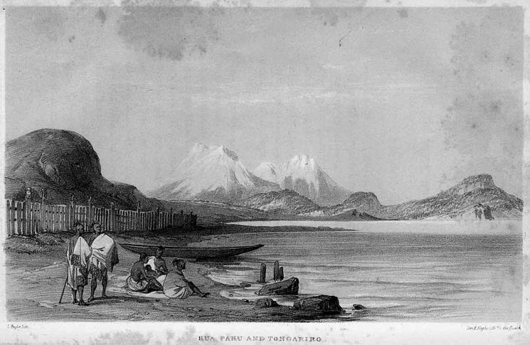
tween them, the rain and melted snow had collected into ponds, and in the furrows which the rills had made in the pumiceous soil there was ice. The vegetation consisted of several kinds of coarse tufty grass, dry and yellow from the cold of winter. There were scarcely any other plants in the hollow, but on ascending the ridge I found some curious ones; several of them were compositous plants. A dwarf Dacrydium, and a very small Gaultheria with purple berries, were the most interesting. The season, however, was not favourable for botanizing. The crest of this range was covered with large fragments of black vesicular basalt, ten or twelve feet in diameter. From it opened a very novel view over the heights of the Tongariro, from which a cold south-easterly wind blew with much violence. Our height seemed to be 3468 feet above the level of the sea, and 1576 feet above the level of the Taupo lake, as the temperature of the boiling water was 206.5 deg., and that of the air 49 deg. 2
Separated from us by a valley about three miles broad, rose a bulky group of mountains, of which a very truncated cone, the Tongariro, bore due south. This cone was only partly covered with snow; white vapours rose from time to time from the top. From the sides of the hills upon which it stood, and which were steep and bare, smoke
[Image of page 345]
OF TONGARIRO.
issued from several crevices. From this point we were unable to see the Ruapahu, although it is only separated from the Tongariro by a narrow valley. It exceeds the Tongariro in height, and is at this time of the year covered with snow very low down, as I afterwards perceived when in the valley. Even in the middle of summer the Ruapahu reaches above the limits of perpetual snow. To the westward this group of mountains descends gradually into the valley, and beyond it is the Hauhunga-tahi, which, like the Pihanga, is called the "wife" of the Tongariro in the figurative expression of the natives. Hence the eye sweeps over a moderately undulating country to Cook's Straits, where, at a distance of about seventy miles, Taranaki, or Mount Egmont, appeared rearing its peak above the clouds. It bore S. 60 deg. W. The whole of the country between the Tongariro and Mount Egmont seemed to be covered with impenetrable forest, with the exception of the immediate base of the former, which was covered with discoloured and coarse tufty grass.
In the valley below is a lake of about three miles in length, the Rotu-Aire, which forms the principal source of the river Waikato. Another lake of less extent was visible, surrounded by wooded mountains, of which one was the Pihanga. They formed a perfect basin for the lake, the level of which was evidently above that of Rotu-Aire. It is called Rotu-Ponamu.
[Image of page 346]
VOLCANIC MOUNTAIN
We descended the hill through a very thick brushwood, which, however, near the borders of Rotu-Aire gave place to trees of high growth, especially matai and totara. In this forest the natives had cleared large patches of ground, and the vigour of the plantations showed the primitive fertility of the soil. The repast with which they furnished us consisted of a small fresh-water fish 3 boiled into a soup, and most excellent potatoes and turnips. After passing this plantation we halted for the night at a village on the borders of the lake, where we were well received, and enjoyed in the evening a full and clear sight of the Tongariro gilded by the setting sun. Rotu-Aire was bordered on one side by a stately forest, in every part of which patches of native cultivation and houses were seen. The base of the Tongariro itself had a seam of forest, and the landscape was altogether one of the most attractive I had seen in New Zealand. Several pas were visible, and enlivened the scene, and on a rocky tongue of land, which stretched into the lake, there was a very large fenced-in village. But here, after having reached the foot of Tongariro, to ascend which we had come so great a distance, we met with an obstacle which quickly put an end to all our gratification. We could not persuade the natives to allow us to ascend the principal cone, which we might have accomplished in four hours. The head chief of the Taupo tribes, Te Heu Heu,
[Image of page 347]
OF TONGARIRO.
was absent on a war excursion to Wanganui, and before he went he had laid a solemn "tapu" on the mountain, and until his return they could not grant us permission to ascend it. This "tapu" was imposed in consequence of a European traveller of the name of Bidwill having gone to the top without permission, which had caused great vexation, as the mountain is held in traditional veneration, and is much dreaded by the natives, being, as they tell you, the "backbone of their Tupuna," or great ancestor, and having a white head, like their present chieftain. Mr. Bidwill has since published a short account of his ascent in his 'Rambles in New Zealand,' from which I will here give an extract, taking the liberty to alter the native orthography as given by him: --
"One great peak of Tongariro slopes up from the lake; but while I was there I could never see the top of it, in consequence of the quantity of vapour always rolling up the side of the mountain from a great many hot-springs which are visible on its sides. From one of these a considerable stream of water runs into the lake, but gets cold by the time it reaches it. The side appeared quite barren, with the exception of a small belt of wood about two-thirds up the visible part of the mountain. Rotu-Aire may be said to be the real source of the Waikato, as the stream which runs out of it is called by the natives; those which run into it are very
[Image of page 348]
MR. BIDWILL'S ASCENT
insignificant. The mean of four days gave for the barometer 28 5/20 inches; thermometer about 56 deg..
"March 2, 1839. Several of my natives being unwell, I left them behind till my return, and started for Tongariro with only two of the lads I brought from Tauranga. Peter went with me, and several people from Rotu-Aire. As usual, the men carried the children, and the women the potatoes, &c. The procession was closed by one or two pigs, which, from the opposition they made to the efforts of their drivers, seemed to have as great a dread of Tongariro as the Mauris themselves. The road led over a tolerably level country covered with grass of many different kinds; the most common was a large wiry one, which I should not think good for cattle. There were, however, many which would be well worth cultivating. I have sent specimens and seeds of most of them to England, where I think they will thrive as well as in their native place. As we skirted the base of the mountain, in order to get at the best place for the ascent, we found the ground in general marshy, and crossed a great many small streams and nearly dry watercourses filled with large stones. The great width of these places would indicate that at some seasons of the year the whole of this country would be impassable from the quantity of water. This was a very dry season, although it had nearly exhausted the torrents. We were on Tongariro all day, but the peak was never
[Image of page 349]
OF TONGARIRO.
visible, in consequence of the mist which always covered the upper regions. I several times accused the natives of leading me astray, as I could not make out the direction in which we were going, as compared with that of the peak as I had observed it from Taupo. About four o'clock we arrived at the junction of two considerable watercourses, where my guides said we must stop, and, as I could not see any vestige of wood anywhere else, I agreed. After we had been there about half an hour, the clouds rolled out of the upper end of the valley where we were, and I saw that the cone was close to us, and then found that this, if any, was the proper place to ascend, which the natives still maintained was impossible. The trees which grew here were small stunted coniferous or taxaceous and composite ones. There were none except on the sides of the watercourse, and they did not lift their heads above the level of the top of the bank on which they grew. The stream which runs here down from the mountain is, I have no doubt (from observations I made afterwards, compared with what I observed at the time of the general direction of the country), the one called the Waipa, 4 or western branch of the Waikato. It is here a noisy mountain-torrent, about four feet deep. I regret that I did not ask
[Image of page 350]
MR. BIDWILL'S ASCENT
what they called it, as it is very likely that they knew it to be a branch of the river called the Waipa when it flows farther to the north. I found out that the road we had travelled was one which formerly led to some part of the Waikato country, but now disused, and that it was the only place where the base of the cone could be seen; that nobody had ever approached nearer than we now were; and that the reason was, they were afraid. They said that formerly when they passed this point of the road they used to cover their heads with their mats, because it was 'tapu' to look at the mountain, or at least the peak. The night was exceedingly cold, but I did not feel it so much as I did on the Waikato. I found here a most curious little plant of the yew family (Dacrydium); it was not larger than a clump of moss, and was mistaken for a moss by me when I first saw it. I found here also the curious Forstera sedifolia, and many new composite plants and Veronicas.
"March 3rd. ---When I arose in the morning I was astonished to see the mountains around covered with snow, except the cone, which was visible from its base to the apex, and appeared quite close. The natives said the mountain had been making a noise in the night, which, at the time, I thought was only fancy: there seemed to be a little steam rising from the top, but the quantity was not sufficient to obscure the view. I set off immediately after breakfast, with only two natives, as all the others were
[Image of page 351]
OF TONGARIRO.
afraid to go any nearer to the much-dreaded place; nor could I persuade the two who did set off with with me to go within a mile of the base of the cone. They, however, made a fire of such small hushes as they could collect, and waited for me till I got back. As there was no road, I went as straight towards the peak as I found possible, going over hills and through valleys without swerving to the right or left. As I was toiling over a very steep hill I heard a noise which caused me to look up, and saw that the mountain was in a state of eruption: a thick column of black smoke rose up for some distance, and then spread out like a mushroom. As I was directly to windward, I could see nothing more, and could not tell whether anything dropped from the cloud as it passed away: the noise, which was very loud, and not unlike that of the safety-valve of a steam-engine, lasted about half an hour, and then ceased after two or three sudden interruptions; the smoke continued to ascend for some time afterwards, but was less dense. I could see no fire, nor do I believe that there was any, or that the eruption was anything more than hot water and steam, although, from the great density of the latter, it looked like very black smoke. I toiled on to the top of a hill, and was then much disappointed that the other side of it, instead of being like what I had ascended, was a precipice, or very deep ravine, with a large stream of water at the bottom. With some difficulty I managed to get down; and, on ascending the other
[Image of page 352]
MR. BIDWILL'S ASCENT
side, I found myself in a stream of lava, perfectly undecomposed, but still old enough to have a few plants growing among the fissures. As I progressed towards the cone, which now seemed quite close, I arrived at another stream of lava, so fresh that there was not the slightest appearance of even a lichen on it, and it looked as if it had been ejected but yesterday. It was black, and very hard and compact, just like all the lava I have seen in this country; but the two streams were very insignificant, not longer at the utmost than three-quarters of a mile each. I had no idea of the meaning of a 'sea of rocks' until I crossed them; the edges of the stony billows were so sharp, that it was very difficult to pass among them without cutting one's clothes into shreds. I at last arrived at the cone: it was, I suppose, of the ordinary steepness of such heaps of volcanic cinders, but much higher. I estimate it at 1500 feet from the hollow from which it appears to have sprung. It looks as if a vast amphitheatre had been hollowed out of the surrounding mountains in order to place it in. The sides of all the mountains around are quite perpendicular, and present a most magnificent scene. Thermometer at the base of the cone, fine sunshine, 65 deg. in sun; no shade to be had: barometer 25 14/20.
"The cone is entirely composed of loose cinders, and I was heartily tired of the exertion before I reached the top. Had it not been for the idea of standing where no man ever stood before, I should
[Image of page 353]
OF TONGARIRO.
certainly have given up the undertaking. A few patches of a most beautiful snow-white Veronica, which I at first took for snow, were growing among the stones, but they ceased before I had ascended a third part of the way. A small grass reached a little higher, but both were so scarce that I do not think I saw a dozen plants of each in the whole ascent. After I had ascended about two-thirds of the way I got into what appeared a watercourse, the solid rock of which, although presenting hardly any projecting points, was much easier to climb than the loose dust and ashes I had hitherto scrambled over. It was lucky for me another eruption did not take place while I was in it, or I should have been infallibly boiled to death, as I afterwards found that it led to the lowest part of the crater, and, from indubitable proofs, that a stream of hot mud and water had been running there during the time I saw the smoke from the top. The crater was the most terrific abyss I ever looked into or imagined. The rocks overhung it on all sides, and it was not possible to see above ten yards into it, from the quantity of steam which it was continually discharging. From the distance I measured along its edge, I imagine it is at least a quarter of a mile in diameter, and is very deep. The stones I threw in, which I could hear strike the bottom, did not do so in less than seven or eight seconds, but the greater part of them I could not hear. It was impossible to get on the inside of the crater, as all the sides I
[Image of page 354]
MR. BIDWILL'S ASCENT
saw were, if not quite precipitous, actually overhanging, so as to make it very disagreeable to look over them. The rocks on the top were covered with a whitish deposit from the stream, and there was plenty of sulphur in all directions, but the specimens were not handsome, being mixed with earth. I did not stay at the top so long as I could have wished, because I heard a strange noise coming out of the crater, which I thought betokened another eruption. I saw several lakes and rivers, and the country appeared about half covered with wood, which I should not have thought, had I not gone to this place. The mountains in my immediate neighbourhood were all covered with snow, and much below me. I could not see the sea in any direction. The natives said that from a mountain near, which they pointed out, I could see Taranaki and the island of Kapiti, in Cook's Straits; and as this was much higher, I ought to have seen both places from this spot, but the south and east were entirely invisible from the cloudy state of the sky. I had not above five minutes to see any part of the country, as I was enveloped in clouds almost as soon as I got up to the top. As I did not wish to see an eruption near enough to be either boiled or steamed to death, I made the best of my way down. It unfortunately happened that the highest part of the crater's edge was to leeward, otherwise I might have stayed there a little longer. I had not got quite down to the sandy plain I have spoken of when I heard the noise
[Image of page 355]
OF TONGARIRO.
of another eruption, but am not certain it came from the crater I had just visited. I thought at the time it came from another branch of Tongariro, to the northward, on the top of which I had seen a circular lake of water when on the peak. I was half frozen before I reached the ravine, and thoroughly drenched by the mist, so that I was very glad when I found the place where I had left the natives and the fire. I got back to the tent about seven in the evening. The barometer stood when at the base of the cone at 26.l inches, but I could not take it up farther than the streams of lava, as I had quite enough to do to get myself along, without having anything to hold. The natives said they had heard the eruption which took place as I was returning, and that the ground shook very much at the time; but I did not feel it, perhaps because I was too much occupied with the difficulties of my path."
According to the observations of the barometer which Mr. Bidwill made at the base of the cone, where the mercury stood at 25 14/20 inches, and assuming that his estimate is correct as to the cone itself being 1500 feet high, it would appear that the summit of the Tongariro is about 6200 feet above the level of the sea. That it was not covered with snow must be ascribed to the increased temperature of the cone itself, caused by the internal ebullition. The limits of eternal snow must, however, be lower on the mountains which form the group of the Tongariro than
[Image of page 356]
LAKE ROTU-AIRE.
they are on the coasts, if Mr. Bidwill was not deceived when he says "the mountains in my immediate neighbourhood were all covered with snow, and much below me!" Those who have travelled among the snow-covered ridges of Switzerland are well aware of the illusion of a snowy mountain appearing to be below the point on which the beholder stands, while it is, in fact, much higher. The cause of this is, that distant mountains are taken to be much nearer than they actually are, from the rays of the sun being reflected from the dazzling snow, and showing every feature with great distinctness. The mountains here described by Mr. Bidwill as covered with snow are evidently higher than the cone of the Tongariro, or that which was ascended by him, and form what the natives call Ruapahu, situated a little to the south-east of Tongariro.
Rotu-Aire is one of the sources of the Waikato river. The waters of the lake are carried off by a considerable stream which flows at the southern slope of Pihanga, and, after a course of a few miles, joins the principal stream, which comes from the Ruapahu, and discharges itself into Taupo lake. The natives cannot ascend with their canoes from Taupo into Rotu-Aire, on account of rocks, which obstruct the bed of the mountain-creek, and also by reason of the numerous rapids, the level of Rotu-Aire above the sea being 1709 feet, or 372 feet more than that of Taupo. The temperature of the thermal point
[Image of page 357]
EARTHQUAKES.
at its shores was 208.8 deg., and that of the air 53 deg.; the mean between the latter and that at the level of the sea being taken at 55 deg..
The Tongariro must be regarded as the centre of the modern volcanic action of the northern island of New Zealand; but the traditions of the natives have preserved no account of an eruption of any great extent; they however assert that sometimes thin showers of ashes are ejected from it, and are carried by the wind to some distance. They also say that they sometimes see a luminous reflection on the sky over the top of the crater. It is not ascertained whether the group of Tongariro is also the centre of the slight earthquakes which are felt in New Zealand from time to time. They have been experienced at Port Nicholson, at Kawia on the western coast, at Mata-mata in the valley of the Thames, and at Cloudy Bay in the middle island. In Mata-mata the shocks were only felt in the hills, and not in the valley.
The natives of Taupo and Rotu-Aire, at the base of Tongariro, told me of slight shocks, which proceed from the mountain, and which have occurred from time immemorial, but they have never been sufficiently important to impress a trace on their traditionary legends, unless we assume that some of their myths are records of events which have really happened: such, for instance, as the tale that the two wives of the Tongariro, Pihanga and Hauhun-
[Image of page 358]
LANDSLIPS.
gatahi, were formerly united with him, but quarrelled, and removed each to a distance. That in like manner Mount Egmont and Tongariro were once united, but the two had a dispute, and separated. At Maupere, a lake between the Bay of Islands and Hokianga, the natives have a tradition of a large pa having sunk into the lake. A similar occurrence really happened at Roturua, but the latter was an event entirely local, as the pa was built on the deposits of hot springs, which form a very thin cover over an undermined or soft subsoil. We might be induced to regard Lake Taupo, with the Tongariro, the chain of lakes which runs to the east coast, and the numerous fumeroles, solfataras, and hot-springs in their neighbourhood, as one connected hearth of volcanic action, which terminates in the island of Puhia-i-Wakari, or White Island, which is also a smoking solfatara.
Besides the Waikato river, the Wanganui and the Manawatu, the most considerable rivers in the northern island, take their rise in this group. Like the Waikato, the Wanganui receives a tributary from a lake which is situated at the southern base of Tongariro: this lake is called Taranaki. The natives descend the Wanganui to its embouchure at Cook's Straits in four days.
The Manawatu seems to possess greater advantages. According to the natives of Taupo it is a very winding stream, and consequently forms pad-
[Image of page 359]
PUMICESTONE CLIFFS.
docks. Its shores are less hilly than those of the Wanganui, and are partly open fern or flax land, and partly wooded.
The Rangatiki is a smaller river, also coming from the Tongariro, and falling into Cook's Straits. In Cook's Straits, and at the mouth of the Waikato, I observed a great quantity of pumicestone: all this is carried down from the Tongariro by the rivers Wanganui and Waikato; and it is not improbable that considerable quantities of it are borne by the currents to the shores of New South Wales, where I found it, especially in Newcastle, at the mouth of the Hunter's river. The eastern and the southern shores of the Taupo lake consist of high pumicestone cliffs, which are continually undermined, broken down, and carried away by the current of the Waikato.
The natives of Rotu-Aire are a division of the Taupo tribes, and amount to several hundreds. With the exception that they would not allow us to ascend their mountain--and to grant the permission was, perhaps, really out of their power during the absence of their chief--they were very friendly to us, and appeared to be in a very primitive state, which, however, was not, in my opinion, at all to their disadvantage.
On the 21st of May we returned to Taupo, driving before us two pigs, a present from our kind hosts. Our road led us along the base of the Pihanga, and I gained with difficulty the precipitous
[Image of page 360]
NATIVES NEAR
and rocky basaltic shore of the Rotu-Ponamu, which is surrounded by almost impenetrable underwood. This little lake lies in a perfect funnel, formed by the surrounding mountains, which rise on one side to a crest of considerable height. It is about a mile and a half in circumference, and apparently of great depth, and has no visible outlet. In looking down two days before from the summit of the neighbouring hills, I thought that its level was above that of Rotu-Aire, which is about a mile and a half distant, and I was glad to find this opinion confirmed by a measurement with the thermometer, which showed the boiling-point at 208 deg. Fahrenheit. This, with a mean temperature of 55 deg., gives for the height of the level of Rotu-Ponamu 2147 feet above the sea, being 438 feet above the level of Rotu-Aire, and 810 feet above the level of Taupo lake.
From this point a very good road leads through a delicious, dark, and beautiful forest into the upper part of the delta of the Waikato, the region of the mineral springs which I have above described. When we arrived in the Rapa, we found that two missionaries had come the same day: one, the Rev. Mr. Brown, from Tauranga, in the Bay of Plenty; and the other, the Rev. Mr. Chapman, from Roturua.
Everywhere round Lake Taupo are small native settlements, but the population seems to be scanty, considering the excellent land in the neighbourhood. I do not estimate their total number at
[Image of page 361]
LAKE TAUPO.
more than 3200, including those at Rotu-Aire. The general name of the tribes is the Nga-te-tuaretoa. Their principal points of communication are the coast at Otaki, a settlement of the Nga-te-raukaua, and at the mouths of the Manawatu and Wanganui, in Cook's Straits. With the natives of the latter place their communications have more frequently been hostile than friendly. They attacked them in 1840, but were repelled with great loss; and, as already mentioned, they had again gone thither with hostile intentions. The Church missionaries have a few native catechists here, and Christianity is beginning to spread amongst them. Heu Heu, the principal chief on the lake, told Mr. Chapman, at his last visit, that he would only have one more fight with the tribe at Wanganui, to settle his old grievances, then make a durable peace, settle down, and "believe." The natives whom I met were decidedly the best specimens of the race that I had seen in New Zealand, and excelled in their hospitality towards strangers, in prudent attention to their own affairs, in cleanliness and health, most of those who live on the coasts, and who have become converts to Christianity. I shall always remember with gratitude the manner in which we were treated by Te Heu Heu's brother, a grey-headed old man, who, in the absence of the chief, held the highest authority over the tribe.
In regard to the animal kingdom, the centre of the island is as scantily provided as the rest. The
[Image of page 362]
CLIMATE AND NATIVES
native rat still lingers here and there, although it has disappeared on the coast; the native dog has become a mongrel; ducks, teals, the red-billed porphyrio or pukeko, a large bittern, a tern, two kinds of gulls, cormorants, and some of the smaller birds which also inhabit the coast districts, are found here. In the lakes are three kinds of fresh water fish, of which one is an eel: these form a great part of the food of the natives. The crawfish is also found here, as indeed it is in all the fresh-waters of New Zealand. Wood is sufficiently plentiful to supply the wants of the natives, although on the whole the country is rather scantily furnished with it. The canoes are generally made of totara.
The climate, as was to be expected, is rather more severe in the interior than on the coast, but it seems to be more equable. We often had frost in the morning, but towards noon the thermometer rose to from 65 deg. to 70 deg.. Although the season was far advanced, we enjoyed the most beautiful weather at the very time that excessive rains fell at Auckland. Several times in the night violent winds descended from the heights of the Ruapahu, blowing almost a gale, and more than once upset our tent. When this occurred we were almost benumbed with cold whilst endeavouring to refix our tent according to the shifting of the wind; but the natives from the neighbouring pa always came quickly to our help, generally rushing in a state of nudity out of their
[Image of page 363]
OF THE INTERIOR.
warm houses, and, with mirth and laughter, soon helped the pakea (stranger) to put up his house.
If Tongariri is the right way of spelling the name of the volcano, instead of Tongariro, it is a very appropriate name, as it means "angry south wind;" and I can easily imagine that violent gales, occasioned by the inequality of the temperature, often agitate the waters of this great lake, and that it is not without good reason that the natives are so careful in trusting themselves on it in their flat canoes.
The scenery of Taupo lake, the whole character of the landscape, the freshness and peculiarity of the vegetation, with the white smoke rising around from so many hot-springs, are singularly beautiful, and well calculated to attract visitors from all parts of the world. The excellent disposition of the natives will ensure every one a good reception who does not come with the arrogant and ridiculous prejudices which are too frequently characteristic of a European traveller.
On the 25th of May we took leave of our friends at Te-rapa. There were so few men in the village, that we could not get any new guides for Roturua, but our former guide Titipa offered to conduct us to Motutere, a well-populated pa on the east side of Taupo lake. We accordingly took a canoe, and passed the mouth of the Waikato, which is divided into three arms, of which the largest is about 100 yards broad. Here we landed, and came to a pa,
[Image of page 364]
EMBALMED HEADS.
the high fences of which stretched about half a mile along the banks of the lake, which were strewed over with pumice intermixed with small pieces of black obsidian. The village, although full of well-constructed native houses, had no inhabitants, as it was a pa used only as a place for the tribe to assemble in in times of war. I had leisure to examine it, and found most of the houses ornamented with carvings, and containing the usual domestic utensils of the proprietors. In some boxes which stood upon poles were the bones of children and adults, deposited here as their final resting-place. In the vestibule of one of the houses I found the head of a young girl in a basket, prepared in the manner which has long been so well known, and of which so many specimens have been conveyed to Europe. This was the first time that I had seen one of these embalmed heads. The custom was once very common, but is now falling rapidly into disuse. Not only the heads of enemies were thus prepared and planted upon the palisades which surrounded the pas, but also the heads of relations, as a missionary assured me; and these served from time to time to excite violent grief and expressions of sorrow in the surviving relatives. The high poles which surrounded this pa were carved at the tops with human figures in a defying position, and with a fierce expression of countenance.
Not far from this place we crossed another river. Here a rocky promontory, connected with the main
[Image of page 365]
A CHRISTIAN SETTLEMENT.
by a low strip of land, stretches out into the lake. The alluvium on the banks of the lake is gradually increasing, as is shown by low parallel ridges along the shore, indicating the former margins. Towards evening we passed another large creek nearly opposite the outlet of the Waikato, and arrived at Motutere, a large pa built on a tongue of land which reaches out into the lake. The natives were few, as the greater part were living at a settlement in the neighbouring hills, where they had their plantations. This was a Christian settlement; and Aberahama, or Abraham--such was the name of the principal man--lodged us in the church. Titipa warmly recommended us to our new entertainers, and the next morning took his departure. He had become so attached to us, that he could scarcely tear himself away. He turned back again and again, to see us once more, and to expatiate upon our merits to those into whose kind keeping he had safely delivered us, and to recommend them to treat us with the same care as he had done. He had shown himself during the whole period of our acquaintance with him a noble fellow, and of the most generous and disinterested disposition.
The rocks near Motutere at some places approach close to the banks of the Taupo lake, at others retreat farther inland, where they form high cliffs. They are composed of a clayey lava, sometimes hard and basaltic, sometimes striped like jas-
[Image of page 366]
INJURIOUS EFFECTS OF
per. From Motutere we enjoyed a fine sight of the Ruapahu and Tongariro.
26th. --The reason why Titipa would not accompany us any farther was, that hostilities existed between the tribe of Roturua and his own, that of the Waikato. Three natives remained with us, but, being slaves, they had nothing to fear. Abraham, however, had promised to procure us men; we therefore started on the 26th in one of his canoes, and pulled for a few miles along the shore. We then landed, and struck inland over an extremely hilly country, to a settlement in the forest, where we found a good number of natives very busy in constructing houses and clearing the land for the coming spring. They have an implement made of very hard wood with a horizontal piece attached to it, and with this tool they work very expertly. A tufaceous gravel constitutes part of the soil covering these hills, which show in some places great fertility. The tribe living here is called Nga-te-terangita, a division of the Nga-te-tuaretoa.
It is evident that forest has at some former period covered a greater extent of land in the neighbourhood of Taupo than it now does; it does not appear to have been destroyed by volcanic eruptions, but by the fires kindled by the natives in order to clear the ground for the purpose of cultivation Notwithstanding this former forest, the
[Image of page 367]
CLEARING BY BURNING.
soil seems to be almost entirely made up of tufaceous and pumicestone lapilli; and it appears to me to be very probable that the vegetable earth which must have existed in such places has filtrated through the porous subsoil, and it may therefore be expected that a judicious over and underworking would greatly improve the land. I will make one observation here, which, although it cannot be new to practical farmers, is at variance with the opinion of a great many colonists who are not farmers, and may, perhaps, be useful. The colonists to whom I allude believe that burning the vegetation which covers the land, whether consisting of fern, bushes, or forest, improves its condition. In large tracts of alluvial soil, which is per se generally rich, as on the plains of the Mississippi, in the deltas and courses of the Rhine and Danube, the burning of the forest must certainly be the quickest way of clearing the land, and the loss of vegetable matter in the process of burning, where there is a great depth of alluvial soil, cannot be of any great importance: but in New Zealand the plains are not, strictly speaking, the produce of the rivers; they are a table-land, composed of a stiff clay, which can scarcely be worked, and which was deposited as we now find it, not by the rivers, which are too insignificant to produce such results, but at the original formation and heaving up of the land. At the borders and outlets of the rivers there is only a small extent of true alluvial soil, the rest derives all
[Image of page 368]
INJURIOUS EFFECTS OF
the fertility it possesses from a vegetation which has covered it from the beginning, has decayed annually through ages, and has thus formed a layer of vegetable mould, in most cases very thin. If this vegetation be burnt down, the wind carries away the light ashes--another vegetation springs up, but less vigorous than the first, until by repeated conflagrations the land becomes perfectly exhausted.
Large districts in New Zealand have in this manner been rendered very poor. If the soil is originally covered with a forest, the vegetation after the first conflagration is a luxuriant underwood; if this is burnt down in its turn, high fern and flax spring up; if the burning is repeated, the new flax is much lower, the fern less vigorous; they intermix with the Leptospermum and Gaultheria, which delight in a meagre clayey soil, until at last stunted fern, rushes, club-mosses, and meagre shrubs of Leptospermum are the only plants which the soil is capable of producing; and many places are even quite bare, and show the white clay, which resembles pipe-clay. As the natives, from a knowledge of the nature of their plains, prefer, with few exceptions, the scattered ravines and hills for their plantations, they are continually lighting fires in order to clear a road when they are travelling, and these have not failed to produce their natural effect. In New South Wales I observed this destructive influence to a still greater degree. When travelling
[Image of page 369]
CLEARING BY BURNING.
up the river Hunter I saw spots in the forest where large gum-trees (Eucalyptus) had been burnt; their existence was indicated by a heap of reddish ashes, and although many months had elapsed since the trees were consumed, yet not even grass had sprung up in their stead.
On the night of the 26th we had a great many natives within and before our tent, listening with profound attention to an explanation of what constitutes a European state. According to the notions they have acquired from the missionaries, the Europeans are divided into--
1. Mihaneres (missionaries).
2. Hohios (soldiers).
3. Revera (or devils).
4. Cookies (or slaves).
The devils comprise all who are neither missionaries, soldiers, cookies, as the captains of vessels, merchants, or gentlemen, with which latter subdivision they have but lately become acquainted. To the cookies belong the artisans, sailors, and so on; and they are, according to a New Zealander's notion, the slaves of the captains, missionaries, or gentlemen. The Protestant natives regard their Roman Catholic brethren as belonging to the devils: they are called pikipo, which M. Pompalier, the Roman Catholic Bishop of New Zealand, explained as being derived from episcopus, which seems to me the most probable derivation. The Protestant missionaries however, say that it means piki-po --always bowing
[Image of page 370]
ROUTE RESUMED
--(piki, bend--po, night). The Protestants, therefore, call their bishop pihopa, while the Roman Catholics have retained the title pikipo for theirs. The spirit of intolerance, in which the natives are confirmed by the missionaries of both religions, has taken a strong hold on their minds, and its effect has been, that the Roman Catholic converts have more firmly connected themselves with those of their countrymen who continue heathens; and their ancient feuds are now carried on under the garb of religion. It is very fortunate for the New Zealanders that a third estate has been established in their country by the introduction of Her Majesty's Government, of which missionaries, soldiers, and devils are equally beloved children, owing to it equal obedience, and enjoying equal rights.
The natives promised us guides to Rotu-rua if we would wait a few days, until they finished the houses which they had begun; but my companion was anxious to be again under the roof of a European, as for several weeks past our food had consisted only of fresh pork and potatoes, without the luxury of salt or anything to give it a relish. As for myself, I bore it very well, although I generally found that the disuse of salt and the uniformity of food caused one or two abscesses, to which I am not subject at other times. These are very common amongst the Europeans on their first arrival in the island: slight wounds are also found not to heal well and quickly. But this seems to be the only
[Image of page 371]
TO ROTU-RUA.
effect produced by the moisture of the air during their acclimatization, as sickness is scarcely known amongst those who have been for some time in the country. After we had in vain tried all our powers of persuasion to obtain guides before the time which they had named, we started on the morning of the 27th with our three remaining natives. I had to make a heavy sacrifice, as I was obliged to leave behind me nearly all my Taupo minerals, and specimens of the mineral waters of the country. The remainder of our luggage made six heavy loads, of which each of us had to carry one. Our stock of provisions was very scanty; our natives were strangers to this part of the island, and did not know the road to Rotu-rua, but we trusted to our good fortune to find both food and road. We returned to the shores of the Taupo lake, and travelled along its eastern bank. The road was very bad; pebbles of pumice and soft sand made walking very difficult. We passed cliffs of pumicestone, which were elevated about one hundred feet above the level of the lake. In some places there was a greyish lava of a striped and variegated appearance, resembling jasper. We came in the evening to a pa near the north-east corner of the lake. It was newly built on a neck of land that separated a small lagoon from the lake, into which, however, the water of the lagoon was discharged by a little stream, which guarded one side of the pa. Around this village the hills were very rugged and steep.
[Image of page 372]
ROUTE TO
The small tribe of natives who lived here at first received us well. They cooked some potatoes for us, and, as a cold south-easterly wind blew, we went into a house to eat them. This house was their Ware Karakia, or church, as they had lately become "missionaries," and they appeared so exasperated at the idea that we should seek shelter in a church, that from this moment we were pronounced to be "devils," and all good feeling towards us was gone. We quitted the building immediately, and pitched our tent; but all our efforts to obtain provisions, and a guide to show us the road, were in vain. We renewed our entreaties on the following day, but could get nothing from them except a small basketful of potatoes, which a man presented to me in consideration of two needles I had given to him. These natives were quite the reverse of our kind friends at Te-rapa; but I afterwards heard that the tribe consisted chiefly of men who had formerly been slaves, and that they were noted for their churlishness and want of hospitality. In spite of all possible caution and forbearance on my part, I have several times met with a bad reception, and always found the cause something connected with missionary, I will not say Christian, observances. The misunderstanding generally arose from some exaggerated idea of what was required of them by the missionaries, a fault very usual among new and zealous converts.
[Image of page 373]
ROTU-RUA.
Two native travellers, who belonged to the tribe of the Nga-te-meniopoto, on the upper part of the Mokau river, and were returning to their homes from a visit to the Waipa, were in the pa, and present during the discussion. They expressed their indignation at the inhospitable treatment we received from their countrymen, who would not even tell us our road. The only information we got was from these two strangers.