[TITLE PAGES]
[Pages i-iii not found]
[Image of page iv]
[Image of page v]
A
VOYAGE
OF
DISCOVERY AND RESEARCH
IN THE
SOUTHERN AND ANTARCTIC REGIONS,
DURING THE YEARS 1839-43.
BY
CAPTAIN SIR JAMES CLARK ROSS , R. N. KNT., D.C.L. OXON., F.R.S., ETC.
WITH PLATES, MAPS, AND WOODCUTS.
IN TWO VOLUMES.
VOL. II.
LONDON:
JOHN MURRAY, ALBEMARLE STREET.
1847.
[Image of page vi]
LONDON:
SPOTTISWOODE AND SHAW,
New-street-Square.
[CONTENTS]
[Image of page vii]
CONTENTS
OF
THE SECOND VOLUME.
CHAPTER I.
Refitting the Ships. -- Fossil Trees of Derwent Valley. -- Geological Remarks. -- Tassman's Peninsula. -- Eagle Hawk Neck. -- Tesselated Pavement. -- Entrecasteaux Channel. -- Timber on the Banks of the Huon. -- Advantages of Port Arthur. -- Mean Level of the Ocean. -- Launceston. -- Prepare for Sea. -- Deviation of the Compass............Page 1
CHAPTER II.
Departure from Hobarton. --Anchor in Port Jackson. -- Term-day Observations. -- Heavy Fall of Rain. -- Appearance and State of Sydney--Paramatta Observatory--Magnetic Observations at Garden Island. -- Sail from Port Jackson. -- Change of Temperature. -- Coast Current. -- Falling Stars. -- Temperature of the Ocean. --Coral Bank. -- Cape Maria Van Diemen. -- Bay of Islands. -- Anchor in the Kawa Kawa. -- The American Corvette, Yorktown. -- Position of Observatory..............33
CHAPTER III.
Suggestions relative to Vaccination. -- Communicate with Captain Aulic. -- Hourly Observations, -- Visits of Awara and Pomare. -- Dissatisfaction of the New Zealanders. -- Influence of the Missionaries. -- Climate. -- Meteorological Abstracts..............65
[Image of page viii]
CHAPTER IV.
Aspect of the Country. -- Visit to the Missionary Station of Waimati. -- Falls of the Keri Keri. -- Kaudi Gum. -- Heki's Pah. -- Heki's Feast. -- Waimati. -- Fishing Party to Lake Mapere. -- Ascent of Puki Nui--Lakes at Taiami. -- Hot Springs of Tuakino. --Return to the Erebus. --Visit from Captain L'Eveque of the French Corvette, Heroine__Capture of the French Whaler, Jean Bart, by the Inhabitants of" Chatham Island. -- Necessity for increased Naval Force in these Seas. -- Tidal Observations..............Page 91
CHAPTER V.
Outrage at the Bay of Islands. -- Sail from New Zealand. -- Proposed Whaling Station at Auckland Islands. -- Dangerous Reefs. --North-west Reef and Dangers off Chatham Island. -- Nimrod Islands. -- Penguins. -- Appearance of Land. -- Circle of Mean Temperature of the Southern Ocean. -- First Iceberg seen--Focus of Greater Intensity. -- Enter the Pack. -- Animalcule. -- Magnetic Observations on the Ice. -- Beset in the Pack. -- Meteorological Abstract for December................125
CHAPTER VI.
Cross the Antarctic Circle. -- Driven back to the Northward. -- The Great Penguin--Seals. -- Fish. -- Animal Life -- Beset in the Pack. -- Gale in the Pack. -- Perilous Situation of the Ships. -- Damages sustained during the Gale. -- Repair Damages. -- Closely beset in the Pack. --Meteorological Abstract for January............55
CHAPTER VII.
Breadth of the Pack. -- Refraction. -- Heavy Swell in the Pack. -- The clear Sea in sight. -- Gain the open Water. Proceed to the Southward. -- Becalmed. -- Large Iceberg seen last Year--Severe Temperature. -- Stopped by the great Icy Barrier. -- Furthest South Latitude, 78 deg. 10'. --
[Image of page ix]
Exploration of the Barrier. -- Bear up for the Falkland Islands. -- Strength of the Bay Ice. -- Running to the Northward. -- Aurora Australis. -- Meteorological Abstract for February............Page 181
CHAPTER VIII.
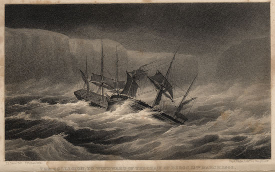
Magnificent Range of Bergs. -- Colour of the Sea. -- Northeasterly Gale. -- Recross the Antarctic Circle. -- Collision with the Terror. -- Loss of Bowsprit -- The Stern-board. -- The Escape. -- Unusual Phenomenon. --Repair Damages. -- Focus of Greater Intensity. -- Circle of Mean Temperature of the Ocean. -- Meteorological Abstract for March. -- Current off Cape Horn. -- Beauchene Island. -- Anchor in Port Louis, East Falkland Island..............213
CHAPTER IX.
Land the Observatories. -- Shooting Parties. -- Account of a Wild Cattle Hunt. -- The Ships hauled up to repair. -- Arrival of Her Majesty's Ship Carysfort, with Provisions and Stores. -- Refitment of the Ships. -- Port William. -- Removal of the Settlement from Port Louis to Port William -- Botanical Notice--Grasses. --Balsam Bog. --Flowers. -- Lichens. -- Seaweeds. -- Mosses. -- Ferns. --Esculent Plants. -- Tussock Grass of the Falkland Islands..............241
CHAPTER X.
Sail from Port Louis. -- Bank discovered. -- Depression of Temperature. -- Cape Horn. -- Anchor in St. Martin's Cove. -- Natives of Hermite Island. -- Its Botanical Productions. -- Trees. -- Alpine Plants. -- Flowering Plants. -- Plants common to Britain. -- Mosses and Esculent Plants.............279
CHAPTER XI.
Natives of Furgia. -- Weapons. --Birds. -- Climate. -- Meteorological Abstract for October. --Prevailing Winds -- "Williwaws." -- Tides. -- Permanent Mark at the Mean Level of the Sea. -- Sail from St. Martin's Cove. -- Burwood Bank.
[Image of page x]
-- Beauchene Island. -- Anchor in Port Louis. -- English Barque, Governor Halkett. -- Her Majesty's Ship Philomel. -- Trees from Hermite Island planted. -- Result of Observations. -- Tides. -- Permanent Marks to indicate the Mean Level of the Ocean...............Page 303
CHAPTER XII.
Route determined. -- Sail from Falkland Islands. -- Circle of Mean Temperature of the Ocean. -- Make the Pack. -- Land discovered. --Danger Islets. --Whale Fishery. --Mount Percy. --Meteorological Abstract for December. -- D'Urville Monument. -- Mount Haddington. -- Cockburn Island -- Its Botany. -- Admiralty Inlet. -- Fixed Land Ice. -- Clear the Main Pack. -- Meteorological Abstract for January...............321
CHAPTER XIII.
Clear the Pack. -- Cross the Line of No Variation. -- Position of Magnetic Pole. --Enter Antarctic Circle--Meteorological Abstract for February. -- Deep Soundings. -- Between Bellinghausen and Weddell's Tracks reach Latitude 71 deg. 30' S. -- Gale at Pack Edge. -- Perilous Situation for several Days. -- The great Comet. -- Recross Antarctic Circle. -- Search for Bouvet Island. -- Various Accounts of its Position. -- Last Iceberg seen. -- Circle of Mean Temperature of the Southern Ocean. -- Meteorological Abstract for March. -- Anchor in Simon's Bay. -- Touch at St. Helena and Ascension Islands. -- No Soundings with four thousand six hundred Fathoms, the greatest Depth yet reached. -- Arrive at Rio--Sail for England. -- Cross the Line of No Dip. -- Atmospheric Pressure in the Southern Hemisphere. -- Arrive in England................355
[Image of page xi]
LIST OF PLATES AND MAPS
IN
THE SECOND VOLUME.
| The Collision
|
(Frontispiece. )
|
| Cape Horn.
|
Chap. I.
|
| Seal Hunting.
|
Chap. II.
|
| Catching Great Penguins.
|
Chap. IV.
|
| Pushing through the Pack.
|
Chap. VI.
|
| A Gale in the Pack
|
p. 169
|
| The Erebus passing through the Bergs
|
p. 220
|
| Tussac Grass of Falkland Islands.
|
Chap. VIII.
|
| Hunting Wild Cattle in the Falkland Islands.
|
Chap. IX.
|
| Mount Kater, Hermite Island.
|
Chap. X.
|
| Balsam-bog Plant.
|
Chap. XI.
|
| Cockburn Island and Admiralty Inlet.
|
Chap. XII.
|
| Deep Soundings.
|
Chap. XIII.
|
| Louis Philippe Land (Map)
|
p. 329
|
| Mount Haddington and Cape Gage
|
p. 387
|
| South Polar Chart
|
(at the end. )
|