[TITLE PAGE]
[Image of page i]
ROTOMAHANA;
AND
THE BOILING SPRINGS
OF
NEW ZEALAND.
[Image of page ii]
CHISWICK PRESS:--PRINTED BY WHITTINGHAM AND WILKINS,
TOOKS COURT, CHANCERY LANE.
[Image of page iii]
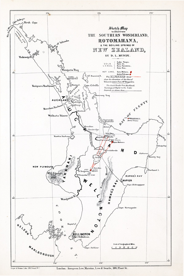
ROTOMAHANA;
AND
THE BOILING SPRINGS
OF
NEW ZEALAND.
A PHOTOGRAPHIC SERIES OF SIXTEEN VIEWS
BY
D. L. MUNDY.
WITH DESCRIPTIVE NOTES
BY
FERDINAND VON HOCHSTETTER,
PROFESSOR OF THE POLYTECHNIC INSTITUTION OF VIENNA.
"O ye Fire and Heat, bless ye the Lord;
Praise him, and magnify him for ever!"
LONDON:
SAMPSON LOW, MARSTON, LOW, AND SEARLE,
CROWN BUILDINGS, FLEET STREET.
1875.
(All Rights reserved.)
[DEDICATION]
[Image of page iv]
TO THE
HONOURABLE JULIUS VOGEL,
PRIME MINISTER OF NEW ZEALAND,
THIS ACCOUNT OF THE SOUTHERN WONDERLAND, ROTOMAHANA,
AND THE BOILING SPRINGS OF NEW ZEALAND,
IS DEDICATED BY
D. L. MUNDY.
[CONTENTS]
[Image of page v]
CONTENTS.
I. THE ROTOMAHANA, OR HOT LAKE. NORTH-EAST VIEW, WITH THE TARAWERA MOUNTAIN.
II. THE ROTOMAHANA. SOUTH-WEST VIEW, WITH THE ORUAKORAKO MOUNTAIN.
III. TE TARATA, OR THE WHITE TERRACE CASCADE. FRONT VIEW.
IV. TE TARATA. MOUTH OF THE BOILING GEYSER.
V. TE TARATA. TERRACES AND CASCADE FROM THE EDGE OF THE CRATER.
VI. TE TARATA. SIDE VIEW, SHOWING THE HOT BATHS.
VII. WAIKANAPANAPA, OR THE BOILING MUD LAKE.
VIII. ROTOPOUNAMU, OR THE GREEN LAKE, WITH THE STEAMING RANGES.
IX. RUA KIWI, OR THE BOILING CASCADE GEYSER.
X. OTUKAPUARANGI, OR THE PINK TERRACE CASCADE.
XI. OTUKAPUARANGI. SIDE VIEW OF ONE OF THE TERRACES.
XII. LAKE ROTORUA, AND THE MAORI VILLAGE OHINEMUTU.
XIII. LAKE TAUPO. SOUTH VIEW, WITH THE VOLCANOES TONGARIRO AND RUAPAHU IN THE DISTANCE.
XIV. LAKE TAUPO. NORTH END AT TAPUAEHARURU, WITH ITS OUTLET INTO THE WAIKATO RIVER.
XV. LAKE TAUPO, BOILING GEYSERS OF TOKANU. GENERAL VIEW LOOKING NORTH-WEST.
XVI. MOUTH OF THE PIRORI GEYSER, AT TOKANU.
The Photographs are reproduced for this publication by the Autotype Process, which renders the Pictures permanent.
[PREFACE]
[Image of page vi]
THE HOT SPRINGS DISTRICT OF NEW ZEALAND.
THE official Government papers of New Zealand contain a letter from the Hon. W. Fox, of Wellington, to the Prime Minister (now Sir Julius Vogel, K. C. M. G.), dated August 1, 1874, in which he recommends that the Colonial Government should take steps for the acquisition of the Hot Springs District, as a public domain, with a view to utilizing this wonderful provision of nature for sanitary purposes. Mr. Fox, after minutely describing the lakes and springs, goes on to observe:--
"It is not my intention to dilate on the wonderful and beautiful which abound in connection with Rotomahana and its terraces. A day spent among them is a new sensation, and must be felt to be understood. I wish rather to draw attention to the different groups of springs, with a view to their sanitary use. At the same time, the idea that these majestic scenes may one day be desecrated by all the constituents of a common watering-place, has something in it bordering on profanity. I would not suggest that their healing waters should be withheld from the weary invalid or feeble valetudinarian. Doubtless their sanitary properties were given them for the good of suffering humanity, and that they should become the Bethesda of New Zealand would detract nothing from the sanctity and grandeur. But that they should be surrounded with pretentious hotels and scarcely less offensive tea-gardens; that they should be strewed with orange-peel, with walnut shells, and the capsules of bitter-beer bottles (as the Great Pyramid and even the summit of Mount Sinai are), is a consummation from the very idea of which the soul of every lover of nature must recoil. The Government of the United States had hardly become acquainted with the fact that they possessed a territory comprising similar volcanic wonders at the forks of the Yellow River and Missouri, than an Act of Congress was passed reserving a block of land of sixty miles square, within which the geysers and hot springs are, as public parks, to be for ever under the protection of the States; and it will doubtless take care that they shall not become the prey of private speculators, or of men to whom a few dollars may present more charms than all the finest works of creation.
"I beg to suggest to the Government of New Zealand that as soon as the Native title may be extinguished, some such step should be taken with regard to Rotomahana, its terraces, and other volcanic wonders. It is to the credit of the Maoris that they have hitherto done all in their power to protect them, and express no measured indignation at the sacrilegious act of some European barbarians who, impelled by scientific zeal or vulgar curiosity, have chipped off several handsbreadths of the lovely salmon-coloured surface of the Pink Terrace.
"I have endeavoured in this imperfect sketch which I have given (and for the details of which I am much indebted to Hochstetter, correcting my own less careful observation,) to draw the attention of the Government to the great value of the sanitary provision which nature has made in the district described. I think the time has come when something practical might be done to utilize that provision. At present, the difficulty of travelling in the Hot Spring country, and the almost entire absence of accommodation for invalids, prevents more than a very small number of persons from visiting it, either for health, recreation, or curiosity. Yet it might be, and is probably destined to be, the sanatorium not only of the Australian Colonies, but of India and other portions of the globe.
"I have, &c.,
"The Hon. the Premier."
"WILLIAM FOX."
[PREFACE]
[Image of page vii]
THE HOT SPRINGS DISTRICT OF
NEW ZEALAND.
THE two large islands which, together with one of insignificant size, constitute New Zealand, perhaps the most attractive and most flourishing of British Colonies, differ considerably in their natural aspects. Both are traversed lengthwise by great mountain ranges, from south-west to north-east, which would form one continuous range but for Cook's Strait between the two islands. The mountain scenery, indeed, of the South or Middle Island, has an Alpine character, with its lofty snow-covered peaks, its immense glaciers, its profound and precipitous ravines, and beds of shattered rock. On the west side of this mighty range, the sea-coast is overhung with dense dark forests; on the east side lie the open plains of Canterbury and of Otago. In the North Island, on the contrary, the upheaved mass of stratified rocks forming the backbone of the country, while it still pursues the same general line of direction, approaches the eastern shore, declining to half the height of the Southern Alps. A broad tableland is left in the middle width of this island, to the west of the backbone range, and is buttressed near the western sea-coast by Mount Egmont. This ground, from Cook's Strait to the Bay of Plenty, is chiefly of volcanic formation, consisting of pumice-stone, tufa, trachyte and rhyolite lava, at first formed by submarine eruptions, but afterwards gradually lifted above the sea. Legends still current among the Maoris, or native people, who call their land Te Ika a Maui, "The Fish of Maui," would seem to be derived from a mythical tradition of its rising from the ocean. This is only one of three distinct volcanic zones in the North Island; and the other two, which lie across the narrow northern peninsula, at Auckland and at the Bay of Islands, are of more recent origin; but their volcanic action is extinct. The region above mentioned, within which is comprised the Hot Springs district, exhibits some of the grandest and rarest volcanic phenomena to be seen on earth. It will suffice, in this introductory chapter, to give the mere outline of a general description.
From the opposite south-west and north-east shores of this territory--that is to say, from Cook's Strait on the one hand, and from the Bay of Plenty on the other, the land gradually rises to an elevation of 2,000 feet. Here stand two high mountains, Ruapahu and Tongariro; the former being an extinct volcano, 9,200 feet in height; the latter, about 6,500 feet, one that is still active. Away to the west, upon a parallel
[Image of page viii]
but different line, stands Taranaki or Mount Egmont, 8,270 feet, a third volcano, but, like Ruapahu, now extinct. From the yet burning crater of Tongariro, in a straight line drawn to the north-east for 200 miles as far as Whakari or White Island, an active volcano twenty-eight miles from the shore in the Bay of Plenty, extends the present range of igneous forces beneath the surface of land and sea. The Maori legend may here again be cited, which relates that a celestial personage, Ngatiroirangi, or the "Runner of the Sky," having alighted upon the snowy summit of Tongariro, felt himself suffering from the cold; he shouted to his sisters, who remained on Whakari, to send him some fire which they had brought from Hawaiki, the mystic home of gods and men. They did so, by the agency of the two Taniwhas, the Earth Spirit and the Water Spirit, who dwell underground. The fire thus transmitted is still current through the long subterranean passage, and bursts forth in a thousand places, from the soil of the plain, the side of the mountain, or the boiling depths of streams and lakes. Another story is, that the national demigod Maui, when he saw the mighty "Fish," as this land is called, emerge out of the sea, was alarmed by its strange fires, and kicked or tossed them along from Tongariro to the Bay of Plenty, in order to quench them. These fables, as poetical as those of the ancient Greeks which professed to account for marvellous physical phenomena, are based also upon correct observation of the line of volcanic action in New Zealand.
Of the wonderful and beautiful effects of such action, as faithfully illustrated by the series of Sixteen Photographic Views presented in this publication, the reader will presently judge for himself. They are similar in kind to others long since renowned, such as the geysers, the solfataras, the steam jets, and other remarkable features of Iceland; as well as the grander display of these natural miracles, lately discovered and examined by a scientific expedition in America, at the head waters of the Yellowstone River. But the more characteristic and peculiar features of the New Zealand Hot Springs region, such as the Cascade Terraces of Rotomahana, have no rival in any part of the globe. The system to which they belong, regarded in general, surpasses every other in variety and extent. We must remark, too, the manifest unity which it possesses, from Lake Taupo, a stupendous central reservoir of water at a great elevation, down to the Rotorua, the Rotoiti, and the Rotoehu, near the sea coast of the Bay of Plenty. To comprehend this system as a whole, throughout the survey of many diverse effects of its subterranean volcanic forces in the disturbance of land and water, it is needful that we should first view Lake Taupo as its actual head. The same lake has another bearing of great importance on the physical geography of the island, from its connexion with the large river Waikato. Few things, indeed, are more singular than the position of Lake Taupo itself, in relation to the general structure of the country where it holds a central place.
The Maori name of Taupo, which means "Darkness," seems to express the sense of mystery that ever invests, to their superstitious imagination, this bottomless Moana, or inland sea, around which yet linger the remnants of the nation, preserving their genuine customs and manner of life. In the centre of the land, 160 miles from the coast of the Bay of Plenty, the lake fills a cavity of unknown depth, a huge hole in the midst of the elevated plateau of volcanic formation. Its water stands at the level of 1250 feet above the sea, yet no soundings have been reached at 200 fathoms. The lake may probably, in former ages, have stood several hundred feet higher, as the Maoris assert that it did; for its shores exhibit three successive terraces or plains, the lower being alluvial, which rise above one another to the general level of the surrounding table-land, 700 feet or 800 feet above the present water. Its area is about 248 square miles, and the length of its coasts nearly 150 miles. The extreme length, N.N.E. to S.S.W., from Tapuehararu to Waihi, is 25 statute miles; the breadth, from Hamaria, on the east side, to Maungahara, on the west, is 20 miles. At its southern extremity,
[Image of page ix]
Lake Taupo receives, in the delta about Tokanu, the four branches of the upper Waikato, having their sources at the feet of Tongariro and Ruapahu and neighbouring mountains. Several other rivers enter the lake on its eastern side. But its only visible outlet is the exit of the Waikato at the north end of the lake, through which that river flows like the Rhine flowing through the Lake of Constance, or the Rhone through the Lake of Geneva. It may, however, be conjectured that a large portion of the water of this vast reservoir is carried off northward by subterranean channels, reappearing in the innumerable hot springs and the many smaller lakes between Taupo and the Bay of Plenty coast. The actual volume of water discharged by the Waikato, as well as the dimensions of the lake, were ascertained at my request by Mr. C. Maling, the government surveyor. It is computed to be 245 1/2 millions of gallons per hour during the lowest summer level of the lake; but in the winter months, July, August, and September, it amounts to 280 million gallons.
The volcanic rocks around Lake Taupo consist of quartzous trachytic lavas, now called rhyolite, in a variety of modifications, crystalline and vitreous, such as obsidian. Together with masses of pumice-stone, they form cliffs on the western shore, to the height of 1,000 feet and more at the promontory of Karangahape; and beyond those tall bluffs rise, in the distance, the wooded ranges of Rangitoto and Tahua, 3,000 feet high, with the pyramidal summit of Titiraupenga. The eastern shore, on the contrary, is mostly flat, with a broad beach of pumice stone, sand, or gravel, across which the Waimarino, the Tauranga, the Hinemau, and the Waitanui flow into the lake. Its most striking features are the rocky peninsula Motuoapa, the wooded island of Motutaiko, with its precipitous northward front, and the steep banks near Motutere. But still more worthy of inspection are the cliffs at Totara, which are curiously variegated, and of a very regular columnar formation, consisting of thin laminated sheets of various rocks, fused together in a streaky mass. Farther north, the visitor's attention is caught by the deep channels which rivers have cut in the pumice-stone tableland above. The Tauhara mountain, an extinct volcano, lifts its graceful head above the outlet of the Waikato. It is, however, by looking southwards up Lake Taupo, that a prospect is gained of the crowning eminences of this region. To the left hand, beyond the wooded range of Kaimanawa, which is ten or fifteen miles east of the lake, are the towering Alpine peaks of the backbone mountains of New Zealand, so different in their aspect from the volcanic cones; these mountains continuing the Ruahine chain from the south, but assuming as they become lower the name of Te Whaiti. But immediately before the spectator, at the south end of the lake (see View XIII.) the giant forms of Tongariro, breathing forth a cloud of steam from its principal crater, and of Ruapahu, clad with perpetual snows, arise behind a group of lesser volcanic mountains. These are Pihanga, called the wife of Tongariro, with Kakaramea, Kuhaua, and one or two others, which the Maoris have fancied to be Tongariro's children. They say that Taranaki was kicked by Tongariro as far off as New Plymouth for his insolence in making love to Pihanga. There is no record of any eruption of lava from the still active craters of Tongariro, the chief of which, called Ngauruhoe, is at the top of a cinder-cone surrounded by a circular wall of cliff, 1,000 feet high, with but one opening, to the west. Cinders and ashes, and hot mud, have been thrown up now and then, breaking the lip of the crater; but its ordinary discharges consist of steam, or sulphurous vapour. It stands about twelve miles from the south end of Lake Taupo.
Such as we have described is the head of the Hot Springs region; and here, in the neighbourhood of Tokanu, at the southern or upper end of Lake Taupo, are found numerous places where the subterranean forces break through the ground, as shown in the Views. But from this locality to the sea-coast, in a direction 36 degrees E. of N., three parallel lines of similar volcanic action not far apart, may be distinctly traced. One is
[Image of page x]
the line drawn from Tongariro to the marine volcano Whakari; and this line includes the hot springs at the head of Lake Taupo, and those of Rotomahana, a long way farther on beyond the Kaingaroa plain. The second line, which follows, to some length, the outflow of the river Waikato from Lake Taupo, is marked by the hot springs and steam jets of Otumaheke and Orakeikorako, on the river's banks, and those of the Pairoa mountain range. The third line of action forming eruptions of this kind is exhibited in the hot springs of Rotorua and the solfataras of Rotoiti, which terminate the notable specimens of volcanic phenomena on land, being situated near the sea coast. It is at Rotomahana, more especially, that the most beautiful and marvellous effects of this action are displayed.
The cause and mode of their production may be explained with brevity in general terms. Water, having descended through fissures into the earth, is heated by volcanic fires, and generates high-pressure steam. This rises, accompanied by sulphurous acid and other gases of volcanic origin, which decompose the nether surface of the lava or other rock that overspreads the neighbouring region. The steam is, meanwhile, partly condensed to hot water; and this, impregnated with acid gases and soluble substances, forms, at the surface, the springs. All the New Zealand hot springs, like those of Iceland, are to be divided into two distinct classes, the one alkaline, the other acid. To the latter belong all the sulphurous hot springs on the Rotomahana, Rotorua, and Rotoiti, characterized by deposits of sulphur or frequent incrustations of alum, which having no periodical eruptions, are either tranquil or in a uniform state of ebullition. This first class of thermal springs is called by the Maoris, Ngawhas, corresponding with those in Iceland called Namur. The second class of alkaline springs is that which bears in Iceland the designation of Hverjar, and to which belong the Geyser and Strokkur; but in New Zealand these intermittent fountains are called Puias, or bursting craters. This word is especially used in the Taupo country to designate the intermittent, geyser-like fountains of Tokanu, of Orakeikorako on the Waikato, and of Whakarewarewa on Lake Rotorua. All the intermittent springs belong to the alkaline class, which, on the cooling and evaporation of the water, deposit great quantities of silica. Springs suited to bathing purposes, the water of which never reaches the boiling point, and all naturally warm baths, are called Waiariki, corresponding to the Laugar of Iceland.
I am indebted to Professor Ferdinand von Hochstetter for much of the information contained in this general account of the Hot Springs district of New Zealand, and he has also kindly furnished the Descriptive Notes, which follow, upon the particular subjects of my Photographic Views.
D. L. Mundy.
LONDON, March 11th, 1875.
|
|
|