LAKE TAUPO, BOILING GEYSERS OF TOKANU.
[Inserted unpaginated illustration]
[Image of page 17]
XV.
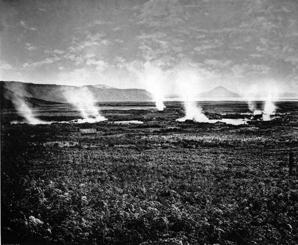
LAKE TAUPO, BOILING GEYSERS OF TOKANU.
GENERAL VIEW LOOKING NORTH-WEST.
THE south shore of Lake Taupo, at the head of the lake, is a flat delta formed by several mouths of the Upper Waikato. It is swampy to the edge of the lake, in some places, and covered with rushes, flax, and manuka scrub. Here are the remains of the village of Tokanu, which was destroyed by the rebel Te Kooti, like other Maori villages and pahs around the lake. In the middle of the low ground here is a series of geysers and mud-holes, occupying two square miles, from the small mountain Maunganamu to the mouth of the Tokanu Creek. This is really the head of the entire geyser system. The ground is paved in all directions with a white lime-like substance, covering spaces a hundred yards square. In this pavement are numerous boiling geysers of clear blue water, sometimes overflowing and adding by their deposit to the thickness of the crust; great care is needed in walking about the place. Several carved posts are set up here by the Maories to show where fatal disasters have occurred.
There are many baths here formed by the natives, converting this hot water to their use, alternately with the cold water of the Tokanu; they also cook their food in the steam holes, which Mr. Mundy used for the same purpose during his stay in the neighbourhood. In the middle of this view is seen the Pirori Geyser, of which a separate illustration is offered on the next page. But nearer to the front is a warm creek, Te Atakoreke, with a temperature of 113 degrees, a favourite bathing-place of the natives. On the further side of the creek, three basins lie close together; Te Puia Nui (the Long Spout) is eight feet wide, and filled to the brim with gently bubbling water; close to this are pools of greyish white mud, at a temperature of 188 degrees.
To the left of the present view is the site of Te Rapa, the native pah which was destroyed in May, 1846, by a landslip of the steaming ranges, and in which the great chief of Taupo, Tukino Te Heu Heu, perished with his six wives and fifty-four of his tribe. He was succeeded by his son, Iwikau Te Heu Heu, who now resides with his people at Waihi. In this vicinity is the beautiful double waterfall, 150 feet high, leaping out of the forest, and filling a rock-basin from which clouds of spray constantly rise, thence descending in a second cascade, to run into Lake Taupo. The lower fall had never been seen, even by the natives, till Mr. Mundy caused it to be cleared of the fuchsia and other trees which obstructed the view. He named it the Alfred Falls, in honour of the visit of his Royal Highness the Duke of Edinburgh to New Zealand.