[TITLE PAGE]
[Image of page i]
MANUAL
OF
NEW ZEALAND GEOGRAPHY,
WITH MAPS AND EXAMINATION QUESTIONS;
BY
THOMAS A. BOWDEN, B.A.,
INSPECTOR OF PROVINCIAL SCHOOLS AND MATHEMATICAL MASTER OF WELLINGTON GRAMMAR SCHOOL,
ASSISTED BY
JAMES HECTOR, M.D., F.R.S.,
GEOLOGIST TO THE NEW ZEALAND GOVERNMENT.
In Two Parts.
PART I.--CONTAINING THE GENERAL GEOGRAPHY OF THE COLONY, WITH A SKETCH OF ITS HISTORY AND PRODUCTIONS.
PART II.--CONTAINING A DESCRIPTIVE ACCOUNT OF EACH PROVINCE OR PRINCIPAL DIVISION.
LONDON:
GEORGE PHILIP AND SON, 32, FLEET STREET.
LIVERPOOL: CAXTON BUILDINGS, SOUTH JOHN STREET.
WELLINGTON, NEW ZEALAND: EDWARD GREAVES SMITH.
And all Booksellers throughout the Colony.
1869.
[Page ii is blank]
[PREFACE]
[Image of page iii]
PREFACE.
The Manual now presented to the public is the offspring of an imperative want rather than of any literary ambition. Children in the Colony are growing up wholly ignorant of the geography of the country in which they live, whilst mistakes not unfrequently occur in English publications referring to the country which are ludicrous to the Colonist. As School Inspector, the Author found a prevailing and unanswerable reason and excuse for neglect in teaching New Zealand Geography in New Zealand Schools, in the non-existence of any manual or any suitable school-map. He has done his best to supply these wants, and if his work is imperfect, the design is laudable. This remark, however, is not made as a refuge for incompetency. He does not decline fair and friendly criticism, but rather looks to it for aid in further perfecting the work in future editions. Nor will he blush if errors are discovered and pointed out. His task as a pioneer has not been an easy one, and he frankly confesses that if he had not met with kind and ready assistance from every quarter, private and official, to which he has applied for information, the completion of it would have been well
[Image of page iv]
nigh impossible. To enumerate the friends to whom the Author has become indebted whilst preparing the sheets for publication would savour of vanity rather than of gratitude; but it is due to the public to refer to the valuable aid afforded to the Author by Dr. Hector, F.R.S., which has mainly encouraged him to prosecute and complete the undertaking, and who, though not responsible for the accuracy of the work, has done very much to ensure it. A tribute of acknowledgment is also due to the well-known and spirited Publishers, who have enabled the Author to present the volume in so convenient and perfect a form, and who have also undertaken to produce, as a valuable companion to the Manual, a well-developed large-scale Map of the Colony, corresponding with their excellent and popular series of School-room Wall-Maps, at a price to the public which can scarcely be remunerative to themselves.
The plan of the Manual can be explained in few words. It consists of Two Parts. Part I., containing the elements, should be committed to memory so far as to secure correct and intelligent answers to the elaborate sets of Examination Questions which are appended to each section. If these are carefully used, the subject will be thoroughly mastered. Part II. contains a descriptive account of each province and distinct division of the Colony, with a general synopsis of its geographical details prefixed to each section. These schedules should be well digested by the student, and the sketch maps copied, until the outline is quite familiar to the mind, whilst the
[Image of page v]
descriptive part is read over from time to time with constant reference to the large Map, which the Author assumes to be always before the pupil. Such a course of study will amply repay the labour, as New Zealand presents to the Geographer an excellent anatomical subject, of convenient size, comprehending nearly every feature of geographical interest to be found in any part of our globe, and will prepare the pupil for geographical studies upon a large scale.
Some difficulty has occurred in fixing the orthography of native names. As might have been expected in connection with a language till recently unwritten, the settlers have frequently adopted, and usage has confirmed, an inaccurate mode of spelling such words. When inconvenience has been thought likely to arise from an attempt to change the incorrect to a correct form, or where legal enactment has stamped the former with seeming authority, it has been left unaltered; in other cases, the correct spelling has generally been substituted.
[Page vi is blank]
[CONTENTS]
[Image of page vii]
CONTENTS.
PART FIRST.
GENERAL GEOGRAPHY OF THE COLONY.
SECTION 1. DISCOVERY AND EARLY HISTORY ... 1
" 2. SIZE AND POSITION OF THE ISLANDS .. 3
" 3. THE COAST AND COAST FEATURES ... 6
" 4. THE MOUNTAINS AND PLAINS, NORTH ISLAND 8
" 5. DO., DO. SOUTH ISLAND ..... 10
" 6. THE RIVERS, NORTH ISLAND .... 13
" 7. DO. SOUTH ISLAND .... 15
" 8. THE LAKES ....... 18
" 9. GEOGRAPHICAL FEATURES GENERALLY ... 20
" 10. GEOLOGY AND MINERALS ..... 23
" 11. METEOROLOGY AND CLIMATE .... 27
" 12. NATURAL HISTORY ...... 29
" 13. NATIVE INHABITANTS ...... 33
" 14. POLITICAL HISTORY ..... 36
" 15. STATISTICS ........ 40
" 16. AUSTRALASIA ....... 43
[Image of page viii]
LIST OF MAPS.
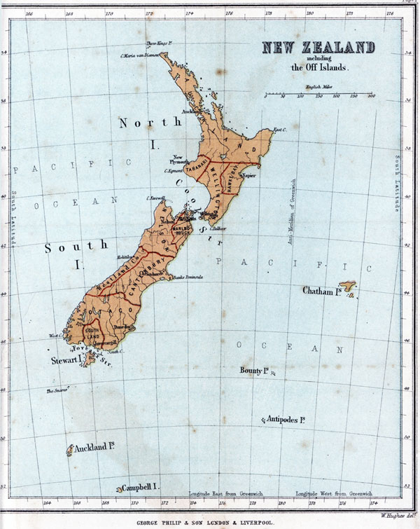
COLONY OF NEW ZEALAND, INCLUDING THE OFF-ISLANDS 1
THE NORTH ISLAND ......... 8
THE SOUTH ISLAND, WITH STEWART ISLAND .... 10
AUSTRALASIA .......... 43
[Image of page ix]
PART SECOND.
INTRODUCTORY CHAPTER ON THE GEOLOGICAL STRUCTURE OF NEW ZEALAND ......... 49
SECTION 1. THE PROVINCE OF AUCKLAND .... 57
" 2. " TARANAKI .... 70
" 3. " HAWKE BAY ... 74
" 4. " WELLINGTON... 79
" 5. " NELSON.... 89
" 6. " MARLBOROUGH.. 100
" 7. " CANTERBURY... 105
" 8. THE COUNTY OF WESTLAND.... 115
" 9. THE PROVINCE OF OTAGO.... 121
" 10. " SOUTHLAND.... 130
" 11. STEWART ISLAND...... 134
" 12. THE OFF-ISLANDS:--VIZ. THE CHATHAM ISLANDS, THE AUCKLAND ISLANDS, CAMPBELL ISLAND, THE BOUNTY ISLETS, AND THE ANTIPODES ISLETS........136
[Image of page x]
LIST OF MAPS.
PROVINCE OF AUCKLAND........57
" WELLINGTON, HAWKE BAY, AND TARANAKI. 79
" NELSON AND MARLBOROUGH.... 89
" CANTERBURY, WITH THE COUNTY OF WESTLAND. 105
" OTAGO AND SOUTHLAND, WITH STEWART ISLAND. 121
THE OFF-ISLANDS:--VIZ. THE CHATHAM ISLANDS, THE AUCKLAND ISLANDS, AND CAMPBELL ISLAND... 136