PART I. GENERAL GEOGRAPHY OF THE COLONY.
[Image of page 1]
MANUAL
OF
NEW ZEALAND GEOGRAPHY.
PART I.
GENERAL GEOGRAPHY OF THE COLONY.
SECTION I.
DISCOVERY AND EARLY HISTORY.
The country of NEW ZEALAND derives its name from the southernmost province of Holland in Europe, having been discovered in the year 1642 by the celebrated Dutch Navigator ABEL TASMAN, who also discovered Tasmania or Van Diemen Land, as well as other islands in Australasia and Polynesia.
The New Zealand group comprises two large islands known as the North and South Islands, with one of smaller size called Stewart Island, and numerous islets. They are situated in the South Pacific Ocean, nearly at the antipodes to Great Britain, so that a line drawn from Greenwich in England through the centre of the globe, and continued to the surface upon the opposite side, would reappear near Antipodes Islets, at a point only distant a few hundred miles in a south-easterly direction, from South Cape in Stewart Island.
These islands were first surveyed by CAPTAIN COOK, the
[Image of page 2]
British Explorer of the Pacific Ocean, and circumnavigator of the world, in 1769; and after a short time they became a favourite resort for British, French, and American whalers, who established extensive and profitable fisheries upon their coasts, and whose land stations were scattered along the southern shores, and on both sides of the straits which divide the islands.
Australian traders soon began to visit New Zealand, and the commerce which sprang up, together with the occasional appearance, at Sydney, of a Chief of the Maori race which inhabited the islands, on board a trading vessel, attracted public attention to the country, which led, in the year 1814, to the establishment of an English Church Mission in the northern part of the North Island, under the direction of the Rev. Samuel Marsden, the Colonial Chaplain of New South Wales. Similar missions also in the northern parts of the country were established by the Roman Catholic and Wesleyan Churches.
In the year 1840, New Zealand became a British Colony, the sovereignty of the British Crown being formally proclaimed by Captain Hobson, the first Governor, and the native rights ceded to the Sovereign of Great Britain by the "Treaty of Waitangi," which was concluded between Governor Hobson and the Maori chiefs at the native settlement of Waitangi, in the Bay of Islands, on the north-eastern shore of New Zealand.
In addition to the group of islands which constitute New Zealand, some other small groups have been annexed to the Colony by Act of the British Parliament, namely the Chatham and Auckland Isles, Campbell Island, and the Bounty and Antipodes Islets.
The Chatham Islands were discovered in the year 1791 by Lieutenant Broughton, Commander of the Brig 'Chatham,' and are situated about 360 miles to the east of New Zealand. The Auckland Isles are a small group, situated about 180 miles to the south of New Zealand, and were discovered by Captain Bristow in the year 1806.
[Image of page 3]
THE ISLANDS--THEIR SIZE AND POSITION.
QUESTIONS FOR EXAMINATION.
1. Who discovered New Zealand? 2. In what year? 3. Why was it so named? 4. What other discoveries did Tasman make? 5. What does New Zealand consist of? 6. Where is it situated? 7. Explain its position with respect to Greenwich. 8. What are the Antipodes Islands? 9 Who first surveyed New Zealand? 10. In what year? 11. What people then began to frequent its shores? 12. What commerce soon sprang up? 13. What drew attention to New Zealand in Sydney? 14. When was the first Church Mission established? 15. When did New Zealand become a British Colony? 16. Who was first Governor? 17. What treaty was concluded with the natives? 18. Where is Waitangi? 19. What other groups of islands belong to New Zealand? 20. When were they united to it? 21. When were the Chatham Islands discovered? 22. Where are they? 23. When were the Auckland Isles discovered? 24. Where are they?
SECTION II.
THE ISLANDS (THEIR SIZE AND POSITION).
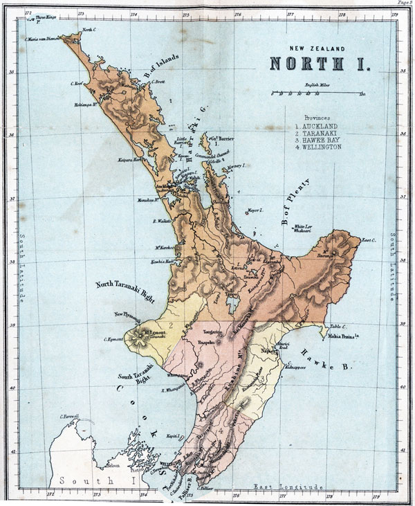
The main islands of New Zealand are known by the names of "The North Island," "The South Island," and "Stewart Island." The native name of the North Island signified "The Fish of Maui" (a native hero or deity); and that of the South Island "The Land of Greenstone," greenstone or jade--the substance from which their weapons of offence, as well as their symbols of authority, were made--being to the natives as valuable as metal is to ourselves. 1
These islands form one extended line for a distance of nearly 1200 miles, their general direction being towards the south-west, excepting that of a northern portion, which bends in a rectangular direction towards the north-west; but a straight line from the North Cape to the South Cape would not exceed 900 miles in length. Their breadth is extremely variable, ranging from a few miles to
[Image of page 4]
nearly 300, the average of the whole being 120. Their area is nearly 100,000 square miles, or rather less than that of Great Britain and Ireland. They are situated between the parallel circles of 34 1/2 and 47 1/2 degrees of south latitude; and between the meridian lines of 166 1/2 and 178 3/4 degrees of east longitude. Their distance from Great Britain, in a direct line, is about 12,000 miles; from the Isthmus of Panama, in the centre of America, about 6,000; from the Equator about 3,000; from the South Pole about 3,000; and from the nearest part of Australia about 1,200.
The North Island is about 500 miles long, and its extreme breadth about 250 miles. Its area is about 44,000 square miles, or rather less than that of England, which is 50,000. It is separated from the South Island by Cook Strait, a channel running almost north and south, and which, at its narrowest part, is only 13 miles across. It is so named after the great navigator, who established a rendezvous upon its south shore, during his several visits to the islands.
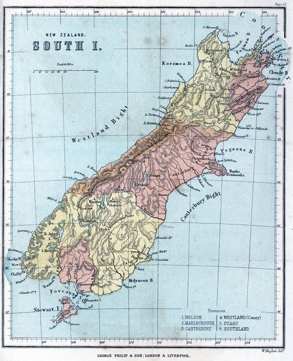
The South Island is also about 500 miles in length, and its greatest breadth about 200. Its area is about 55,000 square miles, or rather less than that of England and Wales together, which is 57,813. It is separated from Stewart Island (so named after the mariner who first discovered it to be an island) by the Foveaux Strait, 15 miles across at the nearest points, and so named by the French navigator D'Urville, after Admiral Foveaux.
Stewart Island is about 40 miles long and 25 broad. Its area is less than 1,000 square miles, and about equal to that of all the minor islands around the coasts of England.
The Chatham Islands are situated on the 44th degree of south latitude, and on the 177th degree of west longitude, their latitude nearly corresponding with that of the central portion of the South Island of New Zealand. They comprise several low hilly islands, and their total area is about 500 square miles.
[Image of page 5]
The Auckland Isles are situated between the degrees of 50 and 51 south latitude, and on the meridian line of 166 deg. East longitude, which nearly corresponds with the longitude of the south-west coast of New Zealand. Their area is about 300 square miles.
In addition to the main islands, there are also in New Zealand a considerable number of islets upon the coast, of which the principal are--the Three Kings, Great and Little Barrier, Kawau, Rangitoto, Waiheke, Great Mercury, Whakaari or White Island, and Kapiti, on the coast of the North Island; and D'Urville Island, Arapawa, Secretary, Resolution, and Ruapuke, on the coast of the South Island. About 60 miles to the south of Stewart Island are some small rocky islets called the Snares; and at a distance of some hundred miles to the south-east, in addition to the larger groups of the Chatham and Auckland Islands, are Bounty Island, the Antipodes Islands, and Campbell Island.
QUESTIONS FOR EXAMINATION.
1. What are the British names of the principal Islands? 2. What did the native name of the North Island signify? 3. What that of the South Island? 4. What is the length of the main group? 5. What its direction? 6. What is its breadth? 7. What is its area? 8. Between what parallel circles is it situated? 9. Between what meridians? 10. What is its direct distance from Great Britain? 11. What from the Isthmus of Panama? 12. What from the Equator. 13. What from the South Pole? 14. What from Australia? 15. What are the length and breadth of the North Island? 16. What is its area? 17. What separates it from the South Island? 18. What are the length and breadth of the South Island? 19. What is its area? 20. What separates it from Stewart Island? 21. What are the length and breadth of Stewart Island? 22. What is its area? 23. Where are the Chatham Islands situated? 24. Where are the Auckland Isles situated? 25. Name the principal islets on the coasts of the North Island. 26. Name those on the coasts of the South Island. 27. Name other islands which belong to New Zealand.
[Image of page 6]
SECTION III.
THE COAST AND COAST FEATURES.
The coast-line of New Zealand is much broken and very irregular. It is large compared with the actual length and breadth of the country, and nearly equals in extent the coast-line of Great Britain; but New Zealand possesses fewer harbours than Great Britain, and these are very unequally distributed.
BAYS, &c. In the North Island the principal bays and gulfs are the Hauraki Gulf between the two northern peninsulas, the Bay of Plenty on the north-east, Hawke Bay on the south-east, and Palliser Bay on the south. The West Coast comprehends two extensive bights divided by Cape Egmont, forming the North and South Taranaki Bights.
In the South Island the principal bays are Golden Bay and Tasman or Blind Bay on the north, Cloudy Bay and Pegasus Bay on the north-east, Molyneux Bay on the south-east, Tewaewae Bay on the south, and Karamea Bay on the north-west; whilst in the middle section of the island each coast contains an extensive bight, Canterbury Bight on the east, and Westland Bight on the west.
HARBOURS. The principal harbours in the North Island are the Bay of Islands on the north-east, Waitemata or Auckland Harbour in the Hauraki Gulf, Napier Harbour in Hawke Bay, Wellington Harbour or Port Nicholson on the south, and Hokianga, Kaipara, Manukau, and Kawhia Harbours, together with the estuary of the Waikato river on the north-west.
The principal harbours in the South Island are Nelson Haven in Tasman Bay, Queen Charlotte Sound, with Picton
[Image of page 7]
THE COAST AND COAST FEATURES.
Harbour, in Cook Strait, Port Lyttelton in Pegasus Bay, Dunedin Harbour, with Port Chalmers on the south-east, and Bluff Harbour and Invercargill Harbour, both in Foveaux Strait. The north-western coast is destitute of any good harbours, but on the south-west are Chalky Bay, Dusky Bay, and Milford Haven.
In Stewart Island are Port Pegasus and Paterson Inlet.
STRAITS. Cook Strait, between the North and South Islands; Foveaux Strait, between the South Island and Stewart Island; Tamaki Strait, between Waiheke Island and the mainland in the Hauraki Gulf; Coromandel Channel, between Great Barrier Island and the northern extremity of Coromandel peninsula; French Pass, between D'Urville Island and the north coast of the South Island; and Tory Channel, between the same coast and Arapawa Island.
CAPES. The principal capes in the North Island are Cape Maria Van Diemen, the most westerly point of the island, and North Cape, its most northerly point, both on the north; Capes Brett and Colville, East Cape, Table Cape, and Kidnappers' Point on the east; Cape Palliser, Taourakira Head, and Cape Terawhiti on the south; Cape Egmont and Reef Point on the west.
The principal capes in the South Island are Francis Head and Cape Jackson on the north; Cape Campbell, East Head, Cape Saunders, and Nugget Point on the east; the Bluff and Windsor Point on the south; and West Cape, Cascade Point, Cape Foulwind, Rock Point, and Cape Farewell on the west, with Cape Stephen in D'Urville Island.
At the south of Stewart Island is South Cape.
QUESTIONS FOR EXAMINATION.
1. Describe the nature of the coast-line of New Zealand. 2. Name and describe the principal bays, &c. in the North Island. 3. Name
[Image of page 8]
and describe the principal hays, &c. in the South Island. 4. Name and describe the principal harbours in the North Island. 5. Name and describe the principal harbours in the South Island. 6. Name the principal harbours in Stewart Island. 7. Where is Cook Strait? 8. Where is Foveaux Strait? 9. Where is the Tamaki Strait? 10. Where is Coromandel Channel? 11. Where is the French Pass? 12. Where is Tory Channel? 13. Name and describe the principal capes in the North Island? 14. Name and describe the principal capes in the South Island. 15. Name the principal cape in Stewart Island.
SECTION IV.
MOUNTAINS AND PLAINS OF THE NORTH ISLAND.
The country of New Zealand is very mountainous, the main ranges lying generally in the direction of the greater axis of each island, namely, from north-east to south-west.
In the northern half of the North Island the mountains do not occupy so much of the land as in other parts, nor do they reach any great height, seldom exceeding an elevation of 1500 feet, with the exception of a few lofty peaks, which are generally isolated in position, and present the features of extinct volcanoes. The most remarkable of these peaks are Mounts Edgecumbe and Ikurangi in the east, and Mount Karehoe on the western coast.
The most extensive range in this part of the island is the Coromandel range, which forms the north-eastern peninsula of the island. This range averages 1500 feet in height, and contains rocks which are richly impregnated with gold.
The numerous islands in the seas adjacent to this part of the island indicate a submarine continuation of this range, the loftier peaks of which still emerge above the level of the ocean, though some of them may be regarded as the summits of isolated volcanic cones similar in character to those enumerated above, but whose bases are at the bottom of the ocean: of these, Rangitoto, near the entrance
[Inserted unpaginated illustration]
[Image of page 9]
MOUNTAINS AND PLAINS OF THE NORTH ISLAND.
of the Waitemata Harbour in the Hauraki Gulf, shows traces of eruption at no very distant period; and Whakaari, or White Island, in the Bay of Plenty, still emits columns of vapour, its summit reaching an elevation of nearly 1000 feet above the sea level.
Towards the middle part of the island, and a little to the south of the 39th parallel of latitude, are three remarkable and very lofty volcanic peaks, Mount Egmont or Taranaki, isolated on the west coast, and Tongariro and Ruapehu, both near the centre of the island. Tongariro is 6500 feet in height, and still manifests occasional symptoms of activity. Ruapehu, which is an extinct volcano, attains to 9195 feet, and Taranaki, also long extinct, is 8280 feet above the sea level. The two latter reach above the limit of perpetual snow, which may here be estimated at about 8000 feet above the sea.
To the eastward of these central peaks lies the main range in the North Island, which extends to its southern extremity, and again from thence, broken only by the Straits and by occasional passes, to the extreme south of New Zealand.
The principal portion of this range in the North Island is the Ruahine chain, which extends in an unbroken length for a distance of about 80 miles, having an average elevation of about 4000 feet. At its southern limit the range is cleft by the Manawatu gorge, through which the Manawatu river flows. To the south of this river the main range continues under the name of the Tararua mountains in the same direction for a distance of about 50 miles, after which it assumes a more easterly direction and the designation of the Rimutaka range, which it retains until it reaches Cook Strait at Taourakira Head, the western promontory of Palliser Bay. Spurs from the Tararua continue towards the western coast, which they reach at the cliff formed by the Paikakariki Hills, at Terawhiti, the south-west point of the island, and at intermediate headlands.
[Image of page 10]
Parallel with the Ruahine range, but extending considerably further towards the north, is another range called the Kaimanawha; and along the south-east coast, at some distance inland, are a series of chains extending in an irregular line from Cape Kidnappers, the southern headland of Hawke Bay, to Cape Palliser, the south-eastern extremity of the island, and bearing the names of the Puketoi, Maungaraki, and Haurangi Mountains.
The principal Plains in the North Island are the Kirikiri plains, near the Bay of Islands; the Thames Valley; the lower, middle, and upper Waikato plains along the river of that name; the Kaingaroa and Taupo plains in the interior; the Rua Taniwha and Wairarapa plains in the east; and an extensive tract of undulating country lying west of the central range of mountains towards Mount Egmont, bordering the South Taranaki Bight, covered with forest, and intersected by the Whanganui and other rivers.
QUESTIONS FOR EXAMINATION.
1. What is the common direction of the mountain ranges? 2. Describe the surface of the northern half of the North Island. 3. Name the principal peaks in this part. 4. Name the principal range in this part. 5. Describe it. 6. What do the neighbouring islets show? 7. Name some islets which still bear traces of late volcanic eruption. 8. Name the principal peaks in the central part of the island. 9. State the height of these peaks. 10. Describe the main range of mountains. 11. What is the Ruahine chain? 12. Describe it. 13. How is it divided from the Tararua mountains. 14. Describe the Tararua mountains. 15. Describe the Rimutaka range. 16. At what points do spurs from the Tararua reach the coast? 17. Describe the Kaimanawha range. 18. Describe the ranges on the south-east coast. 19. Mention the principal plains in the north of the island. 20. Name those in the interior. 21. Name those in the east. 22. Name those in the west.
[Inserted unpaginated illustration]
[Image of page 11]
MOUNTAINS AND PLAINS OF THE SOUTH ISLAND.
SECTION V.
MOUNTAINS AND PLAINS OF THE SOUTH ISLAND.
The main range appears again in the South Island, and extends through its whole length, keeping, however, much nearer to its western than to its eastern coast.
Towards the north of the island the principal ranges diverge like the legs of a compass, forming an eastern branch, which terminates at the promontory of Jackson Head, and a western branch, called the Tasman Mountains, terminating at Cape Farewell. Each of these main branches also sends out spurs or offsets, which strike the coast at Separation and Rock Points on the west, and at the numerous headlands dividing the sounds and inlets which intersect the country lying between Blind Bay and Cloudy Bay, on the east.
Above the fork, whence the two principal chains diverge, stands the lofty Peak of Mount Franklin, 10,000 feet in height, clothed in dazzling snow, and surmounting, like a watch-tower, all the northern region of the island. In the western branch are the noticeable peaks of Mount Arthur, Mount Snowdon, and Mount Peel, the latter being 6000 feet in height; and in the eastern branch are Ben Nevis, Mount Rintoul, and Mount Richmond.
On the west of Mount Franklin is a detached chain, parallel with and near the coast, called the Paparoa Mountains, between the Buller and Grey Rivers, whilst on the eastern side of the said mountain are three lateral and nearly parallel branches, starting from the main range and directed towards the north-east. One of these branches reaches the coast at the White Bluff, a second at Cape Campbell, and the third at Lookers-on Point. The range terminating at Cape Campbell is called the Kaikoura, and
[Image of page 12]
attains an elevation of 9,700 feet in Mount Tapuaenuka. The most southern branch is generally known as the Seaward Kaikoura range, though named by Captain Cook the Lookers-on from a number of natives whom he observed watching his ships. Its highest peak is Mount Kaitarau, 8,700 feet above the sea level.
From Mount Franklin the main range continues towards the south, under the general designation of the Southern Alps, for upwards of 200 miles, forming a well defined mountain chain which culminates towards the centre in the massive peak, the highest elevation in the islands, well named in honour of the British Discoverer of New Zealand, Mount Cook. It is 13,200 feet in height, being no mean rival to Mont Blanc, the monarch of the European Alps, 15,810 feet.
The higher portions of this region are covered with perpetual snow (the elevation of the snow line being about 7,500 feet), and, like the Alpine regions of Europe, contain valleys filled with glaciers or masses of sliding ice, derived from the snow-fields, which form the source and feeders of most of the rivers which flow through the central districts of the island.
The Plains of the South Island lie principally along the valleys of the great rivers, and, for the most part, assume their names; such are the Waimea, Wairau, Awatere, Hurunui, and Waiau Plains, together with the Maruia and Karamea Plains in the north. The Canterbury Plains, on the eastern side of the island, extend for nearly 100 miles between Banks Peninsula and the Southern Alps, whilst wooded plains of a similar character also extend along the western side of the mountains, in which gold is obtained in large quantities.
The upper and lower Taieri, the Manuherikia and Clutha Plains, with the Oamaru, Moeraki, and Southland Downs (resembling in their character the downs of England), constitute the principal plains in the south of the island.
[Image of page 13]
RIVERS OF THE NORTH ISLAND.
Stewart Island is also mountainous. Its highest peak, Mount Anglem, is 3,200 feet high. There is a plain of some extent nearly in the centre of the island.
QUESTIONS FOR EXAMINATION.
1. Describe the main range in the South Island. 2. Describe the branch chains at its northern extremity. 3. Where does the eastern branch end? 4. What is the name of the western branch? 5. Where does it terminate? 6. Where do the spurs terminate on the west coast? 7. Where upon the east coast? 8. Describe Mount Franklin. 9. Name the principal peaks in the western branch. 10. Name those in the eastern branch. 11. Describe the Paparoa chain. 12. Name the points at which the three parallel lateral chains strike the east coast. 13. What is the name of the loftiest of these chains? 14. Give the name and elevation of its highest peak. 15. Name the most southerly of these chains and its highest peak. 16. Describe the Southern Alps. 17. Describe Mount Cook. 18. Give the elevation of the snow-line in this part of New Zealand. 19. Describe the glaciers. 20, Name the principal plains in the north of the South Island. 21. Name those on the east. 22. Name those on the west. 23. Name those on the south. 24. Describe Stewart Island.
SECTION VI.
RIVERS OF THE NORTH ISLAND.
Whilst the mountains of New Zealand vie in grandeur, number, and magnitude with those of other regions of the globe renowned for magnificent or picturesque mountain scenery, its rivers, owing to the narrow breadth of the islands and the direction of the principal mountain ranges, are comparatively small, though usually rapid in their course.
In the North Island the largest river lies to the north-west of the Ruahine Mountains, where the country is less intersected by mountain-chains than in any other part. The Waikato, which is by far the largest river in the North Island, rises on the northern slopes of Mount Ruapehu, and after helping to form the great Taupo Lake
[Image of page 14]
in the centre of the island, flows northwards for the greater part of its course for a distance of 100 miles, when, passing through a gorge in the hills along the coast, it turns sharply to the west, forming a rectangular bend, and makes its way to the west coast. This river is navigable by small steamers for 50 miles, and its estuary can be entered by full-sized vessels. It empties itself into the North Taranaki Bight.
The Waipa is an important tributary to the Waikato, which river it joins on its left bank after a course of 40 miles, about 20 miles above the rectangular bend already mentioned of the principal stream.
The Waiho or Thames, and the Waitoa, with its tributary the Piako, are two rivers which rise on the high table-land between the Waikato River and the Bay of Plenty, and flow in parallel courses towards the north, emptying themselves into the Frith of Thames at the bottom of the Hauraki Gulf. These rivers are only navigable by small vessels.
The Whanganui rises near the centre of the island on the slopes of Mount Tongariro, and flows first in a northerly and afterwards in a south-westerly direction, falling into the South Taranaki Bight near the 40th parallel of latitude. It is navigable at its mouth by vessels of medium size, and by canoes almost to its source.
The Whangaihu, the Turakina, and the Rangitikei, are smaller rivers flowing nearly parallel with the Whanganui, but further towards the south.
The Manawatu rises much further towards the south, and on the east of the Ruahine range, through which it passes by the Manawatu gorge, from which it flows, nearly due west, into the South Taranaki Bight.
The Whakatane rises from the plains on the east side of Lake Taupo, and flows north-east into the Bay of Plenty. The Wairoa in the north, and another river of the same name in the east, flowing into Hawke Bay, with the Ruamahanga in the south, are other considerable
[Image of page 15]
RIVERS OF THE SOUTH ISLAND.
streams in this island. The latter rises on the southern slopes of the Puketoi Mountains, and flows southward in the valley formed between the Tararua range and the east coast chains of mountains, which is called the Wairarapa Valley. Towards the termination of its course it forms the Wairarapa and Onoke Lakes, from the latter of which its waters find their way through a swampy channel into Palliser Bay.
QUESTIONS FOR EXAMINATION.
1. What is the general character of the New Zealand rivers? 2. Where is the largest river in the North Island situated? 3. Mention its name and describe its course. 4. To what extent is it navigable? 5. What is the Waipa? 6. Describe its course. 7. Describe the courses of the Waiho and Waitoa. 8. What is the Piako? 9. To what extent are these rivers navigable? 10. Where does the Whanganui rise? 11. Describe its course. 12. To what extent is it navigable? 13. What are the Whangaihu, Turakina, and Rangitikei? 14. Where does the Manawatu rise? 15. Describe its course. 16. Describe the course of the Whakatane. 17. Name some other considerable streams in the North Island. 18. Where does the Ruamahanga rise? 19. Describe its course. 20. What lakes are formed by it?
SECTION VII.
RIVERS OF THE SOUTH ISLAND.
The rivers of the South Island may be geographically divided into three groups; the first group comprehending those rivers which have their sources in the elevated mass of the central chain, near Mount Franklin; the second group consisting of those which are fed by the glaciers which descend from the lofty Alpine region near Mount Cook; and the third, which includes nearly all the southern rivers, consisting of streams connected with the many large and elevated lakes which stud the southern and south-eastern slopes of the Southern Alps.
[Image of page 16]
In the first or northern group, are the Motueka flowing north, the Buller and the Grey flowing west, and the Wairau, the Waiau-toa or Clarence, and the Waiau-ua or Dillon, flowing east. The Motueka empties itself into Tasman Bay, and the Wairau discharges into Cloudy Bay. Between the Wairau and the Clarence is a smaller stream, the Awatere, flowing parallel with them both, rising in the Fairfield Downs, and separated from the Clarence by the Kaikoura Mountains. All of these rivers rise in the neighbourhood of Mount Franklin, and none of them, except the Buller and Grey, are navigable to any considerable extent. In the valleys of these two rivers there are extensive gold-fields and coal mines, which support a large population.
The principal rivers of the second or central group are the Waimakariri, emptying itself into Pegasus Bay on the east coast, a little to the north of Banks Peninsula; the Rakaia, Ashburton, and Rangitata, flowing by parallel courses into the Canterbury Bight; and the Teremakau, Hokitika, Wairau, Haast, Arawhatta, and Katuka, flowing into the Westland Bight. All of these rivers rise among the glaciers of the Southern Alps, and none of them are navigable by vessels of any size, being generally of the usual character of mountain streams, often swollen into rapid torrents, but at other times expanded over broad shingly beds.
The third or southern group contains the comparatively large river, the Waitaki, the sources of which flow through the lakes Tekapo, Pukaki, and Ohau; and the Clutha, which is the largest river in the South Island, and which rises from several sources, flowing through the lakes Wakatipu, Wanaka, and Hawea, and falls into the sea in Molyneux Bay. These rivers rise almost on the western shores of the island, and flow nearly across its entire breadth, to the eastern coast. The course of the Clutha is about 150 miles, and the volume of water flowing into the Ocean through its channel has been estimated at a
[Image of page 17]
million and a half cubic feet per minute. Its water power, together with that of many neighbouring streams, is extensively used for supplying the sluices used in working the valuable gold-fields which abound throughout their valleys.
The Mataura, rising near Lake Wakatipu, but not now connected with it, is an exception to this class of rivers. It flows into Toetoe Bay in the Foveaux Strait.
The Waiau, flowing through the lakes Te Anau and Manipori into Tewaewae Bay, is, however, another river of the group, none of which, except the Clutha, are navigable.
The principal river in Stewart Island is Lords River, which is navigable for a few miles only.
QUESTIONS FOR EXAMINATION.
1. How may the rivers of the South Island be distributed? 2. What kind of rivers are included in the first group? 3. Of what kind does the second group consist? 4. What kind of rivers form the third group? 5. Name the principal rivers of the northern group. 6. Where do the Motueka and Wairau discharge themselves? 7. Describe the Awatere. 8. Whence do all these livers derive their sources? 9. To what extent are they navigable? 10. What minerals are found in the valleys of the Buller and the Grey? 11. Name the principal rivers of the central group. 12. Where does the Waimakariri empty itself? 13. What rivers flow into the Canterbury Bight? 14. What rivers flow into the Westland Bight? From what sources are all these rivers derived? 16. To what extent are they navigable? 17. What is their general character? 18. Name the principal rivers of the southern group. 19. Through what lakes do the sources of the Waitaki flow? 20. Through what lakes do the sources of the Clutha flow? 21. Describe the course of that river. 22. To what purpose is the water power of the Clutha extensively applied? 23. Describe the Mataura. 24. Describe the Waiau, 25. What is the chief river in Stewart Island?
[Image of page 18]
SECTION VIII.
LAKES.
The Lakes of New Zealand are numerous, and some of them are of considerable extent.
The largest lake in the North Island is Taupo, situated near the centre of the island, and containing an area of about 200 square miles; being nearly equal in size to the Lake of Geneva, in Switzerland. This lake is fed by the river Waikato, which rises a little to the south of the lake, and flows through it in a northerly direction. In the vicinity of Lake Taupo are numerous hot springs, many of which are of an extremely high temperature, and some actually boiling.
Between this lake and the north-east coast, but to the west of the Ruahine and Kai Manawha ranges, is a belt of country about 30 miles in width, which may be properly described as the northern lake country of New Zealand.
This region constitutes one of the physical wonders of the world, being occupied by a succession of hot lakes, mud volcanoes, and springs, throwing up jets of boiling water which can only be compared, for their size, number, and remarkable phenomena, to the long celebrated Geysers of Iceland.
Among the numerous lakes which occur in this district the most considerable are Tarawera, Rotorua, and Rotoiti, of which Tarawera has an area larger than that of Windermere in England.
At the southern extremity of the island, a short distance only from the southern shore, are the Wairarapa and Onoke lakes. They are both fed by the river Ruamahanga, and the area of the Wairarapa Lake is 16 square miles. This lake is very little above the sea level, whilst Lake Taupo is elevated 1250 feet above it.
[Image of page 19]
In the South Island there are a number of large lakes, which are remarkable for their elevation and depth, as well as for the great height of the mountains which surround them.
The greater number of these are situated to the south of Mount Cook, amidst the ranges which form the steep southern slopes of the Southern Alps. The largest are Lakes Wakatipu, Wanaka, Hawea, Te Anau, Manipori, Tekapo, Pukaki, and Ohau. The area of Lake Wakatipu is about 114 square miles, and its elevation upwards of 800 feet above the sea level.
There are also several lakes to the north of Mount Cook, of inferior size to those already mentioned. Of these the most remarkable for size or position are Lakes Rotoroa, Rotoiti, and Tennyson, near Mount Franklin; Lake Sumner on the north-eastern, and Lake Brunner on the north-western, slopes of the Southern Alps; and Lake Ellesmere, an extensive sheet of fresh water, on the eastern coast, south of Banks Peninsula, and which is only separated from the sea by a long and narrow strip of shingly beach, through which its waters occasionally burst.
Besides these fresh-water lakes, there are several inlets of the sea so nearly enclosed by land as to form salt-water lakes or lochs. Such in the North Island are the Hokianga Estuary, and the Kaipara, Manukau, and Kawhia harbours on the west; the Waitemata or Auckland Harbour on the east; and Port Nicholson or Wellington Harbour on the south. And in the South Island, also, are Pelorus and Queen Charlotte Sounds on the north, whilst the numerous sounds on the south-west coast of the island may be included in this class. So also may be Paterson Inlet and Port Pegasus, in Stewart Island.
QUESTIONS FOR EXAMINATION.
1. Are there many large lakes in New Zealand? 2. Where is Lake Taupo? 3. Describe it. 4. By what river is it fed? 5. What
[Image of page 20]
remarkable phenomena are in its neighbourhood? 6. Where is the northern lake country? 7. Describe it. 8. Name the most considerable of its lakes. 9. What is the size of Lake Tarawera? 10. Where are the Wairarapa and Onoke lakes? 11. How are they supplied? 12. How large is the Wairarapa? 13. Describe the lakes of the South Island. 14. Where are they mostly situated? 15. Name the largest. 16. What is the size and elevation of Lake Wakatipu? 17. What lakes exist to the north of Mount Cook? 18. Describe Lake Ellesmere. 19. What other class of lakes are there? 20. Name the lochs of the North Island. 21. Name those of the South Island. 22. Name those of Stewart Island.
SECTION IX.
GENERAL GEOGRAPHICAL FEATURES.
New Zealand furnishes to the student of geography examples illustrative of almost every term used to distinguish the various forms both of land and water. This will be seen by the following classification.
OCEAN.--The coasts of New Zealand are washed by the waters of the South Pacific Ocean.
SEA.--Though not so named, the wide expanse between the islands which is terminated by Cook Strait, is really a sea.
GULF.--The Hauraki Gulf.
BAY.--Bay of Plenty, Hawke Bay, Palliser Bay, North and South Taranaki Bights, Golden Bay, Tasman Bay, Cloudy Bay, Pegasus Bay, Canterbury Bight, Molyneux Bay, Tewaewae Bay, Westland Bight, Karamea Bay.
HARBOUR.--Bay of Islands, Waitemata or Auckland Harbour, Napier Harbour, Wellington Harbour, Hokianga Harbour, Kaipara Harbour, Manukau Harbour, Kawhia Harbour, Nelson Haven, Picton Harbour, Port Lyttelton, Dunedin Harbour, Bluff Harbour, Invercargill Harbour, Port Pegasus, and Paterson Inlet.
[Image of page 21]
CREEK, INLET, OR SOUND.--Queen Charlotte and Pelorus Sounds, Chalky Bay, Dusky Bay, and Milford Haven.
ROADSTEAD.--Ahuriri and Astrolabe Roads.
STRAIT OR CHANNEL.--Cook Strait, Foveaux Strait, Tamaki Strait, Coromandel Channel, French Pass, Tory Channel.
LAKE.--Taupo, Tarawera, Rotorua, Rotoiti, Wairarapa, Onoke, Wakatipu, Wanaka, Hawea, Te Anau, Manipori, Tekapo, Pukaki, Ohau, Rotoroa, Tennyson, Sumner, Brunner, Ellesmere.
LOCH.--Hokianga, Kaipara, Manukau, Kawhia, Waitemata, and Wellington Harbours, Pelorus and Queen Charlotte Sounds, and many inlets on the south-west coast, with Paterson Inlet and Port Pegasus.
FRITH OR ESTUARY.--Frith of Thames, Estuary of Hokianga, and Waikato.
RIVER.--Waikato, Waipa, Waiho or Thames, Piako, Whanganui, Whangaihu, Turakina, Rangitikei, Manawatu, Whakatane, Wairoa, and Ruamahanga, in the North Island. Clutha, Waiau, Mataura, Waitaki, Rangitata, Ashburton, Rakaia, Waimakariri, Teremakau, Hokitika, Wairau, Haast, Arawhatta, Katuka, Grey, Buller, Motueka, Wairau, Waiau-toa or Clarence, Waiau-ua or Dillon, and Awatere, in the South Island.
ARCHIPELAGO.--Bay of Islands, and Hauraki Gulf.
CONTINENT.--This term cannot be properly applied to any part of New Zealand, but is well illustrated by Australia.
ISLAND.--North and South, Stewart, Chatham, Auckland, Campbell, Bounty, Antipodes, Three Kings, Great and Little Barrier, Kawau, Rangitoto, Motutapu, Waiheke, Mercury, White or Whakaari, Kapiti, D'Urville, Arapawa, Secretary, Resolution. Ruapuke islands, and the Snares.
PENINSULA.--Auckland, Coromandel, Mahia, Banks, and Otago peninsulas.
[Image of page 22]
ISTHMUS.--Auckland isthmus.
DELTA.--Wairau delta.
PROMONTORY.--Pelorus and Farewell promontories.
CAPE, POINT, AND HEADLAND.--Maria Van Diemen, North, Brett, Colville, East, Table, Palliser, Terawhiti, and Egmont capes; Kidnapper and Reef points, and Taourakira Head, in the North Island. Francis and East heads; Jackson, Campbell, Saunders, West, Foul-wind, and Farewell capes; Nugget, Windsor, Cascade, and Rock points, and the Bluff, in the South Island;--with South Cape in Stewart Island, and Cape Stephen in D'Urville Island.
MOUNTAIN CHAIN.--Ruahine, Tararua, Rimutaka, Kaimanawha, Puketoi, Maungaraki, Haurangi, in the North Island. Southern Alps, Spencer, Tasman, Paparoa, Kaikoura, Lookers-on.
MOUNTAIN PEAK.--Edgecumbe, Ikurangi, Karehoe, Egmont or Taranaki, Tongariro, Ruapehu, Franklin, Arthur, Snowdon, Ben Nevis, Rintoul, Richmond, Tapuaenuka, Kaitarau, Cook, Aspiring, and Earnslaw, with Mount Anglem in Stewart Island.
PLAIN OR LOWLAND.--Kirikiri Plains, Thames and Waikato Valleys, Rua Taniwha and Wairarapa Plains, in the North Island; Waimea, Wairau, Awatere, Hurunui, Waiau, Maruia, Karamea, Canterbury, Taieri, Manuherikia, and Clutha Plains, in the South Island.
PLATEAU, TABLE-LAND, OR HIGHLAND.--Kaingaroa and Taupo Plains, Timaru, Oamaru, Moeraki and Southland downs.
VALLEY.--Waikato, Thames, Rangitikei, Wairarapa, Wairau, Amuri, Waitaki, Clutha, Grey, Buller.
VOLCANO.--Tongariro, Whakaari.
GLACIER.--Godley Glacier, and others in the Southern Alps.
GEYSER.--In the northern lake district.
DESERT AND OASIS.--None in New Zealand.
[Image of page 23]
QUESTIONS FOR EXAMINATION.
1. What examples does New Zealand furnish? 2. Mention an ocean washing New Zealand. 3. A sea. 4. A gulf. 5. Name the bays. 6. The harbours. 7. The creeks, inlets, and sounds. 8. The roadsteads. 9. The straits and channels. 10. The lakes. 11. The lochs. 12. The friths and estuaries. 13. The rivers in the North Island. 14. The rivers in the South Island. 15. The Archipelagos. 16. A continent, if any. 17. The islands. 18. The peninsulas. 19. An isthmus. 20. A delta. 21. The promontories. 22. The capes, points, and headlands in the North Island. 23. The same in the South Island. 24. The mountain chains in the North Island. 25. The same in the South. 26. The mountain peaks in the North Island. 27. The same in the South. 28. The plains or lowlands. 29. The plateaus, table-lands, or highlands. 30. The valleys. 31. The volcanoes. 32. The glaciers. 33. The geysers. 34. The deserts and oases, if any.
SECTION X.
GEOLOGY AND MINERALS.
The Geology of a country is a subject of much interest and importance, as it helps to explain the causes which have occasioned its physical configuration, and assists in the discovery of the mineral treasures which it contains. The crust of the globe is that portion of it which Ave are able to examine, or concerning the nature of which we can form a judgment from observations made at or near the surface. It is found to consist of a variety of rocks, which differ from one another, and are classed according to the following characteristics:--
First.--The most common and numerous rocks are those called Aqueous or Sedimentary, such as limestones, sandstones, marls, and clays, which form layers or strata, and appear to have been deposited under water, like mud and sand are now; or formed like beds of shells or shingle, or reefs of coral. These often contain fossils, i.e., remains or traces of animal or vegetable bodies, embedded in them.
[Image of page 24]
Second.--Volcanic Rocks, such as lava, ashes, basalt, tuff, &c., which have been produced at or near the earth's surface, not by the agency of water, but by the action of fire or subterranean heat. These are generally unstratified and without fossils, and are more partially distributed.
Third.--Plutonic Rocks, such as granite, porphyry, &c., also produced by fire, but at a considerable depth in the earth, under great pressure, and which, having cooled slowly, are more crystalline in texture than volcanic rock, and without the pores or little cells which the expansion of enclosed gases occasions in ordinary lava.
And lastly, there are the Metamorphic or stratified crystalline rocks, such as marbles, gneiss, mica-schist, and clay-slate, which differ from the aqueous rocks in retaining no trace of fossils, or of pebbles, sand, scoriae, or fragments of other rocks embedded in them; and though often equally crystalline with granite, they differ from the Plutonic rocks by their division into beds, which correspond in form and arrangement with those of sedimentary formations. These seem to have been originally deposited from water, in the actual form of sediment, but to have been subsequently so altered by subterranean heat as to have assumed a new texture.
In New Zealand the two latter classes of rocks are confined to the South Island, and to its southern and western parts, whilst the Volcanic rocks are limited to certain areas which are most extensive in the North Island; and the aqueous rocks are distributed alike throughout both.
It is among the rocks of the first and last of the above classes that the most valuable minerals of the country have been originally deposited, the metamorphic rocks furnishing a large proportion of the gold that has been discovered, and the sedimentary strata of different ages containing extensive fields of coal, of various degrees of excellence.
[Image of page 25]
The mineral resources of the colony, which are contained amidst its extensive and varied geological deposits, remain at present very imperfectly explored. Sufficient, however, have been discovered to indicate the existence of mineral wealth, unsurpassed, if not unequalled, by any other region of the globe of equal extent. What is already known upon this subject, has been summed up by the Commissioners of the New Zealand Exhibition, held at Dunedin in 1865, of whose report upon the subject the following is, in part, an abstract:--
GOLD, the most precious metal, is found in gold-fields of almost unequalled richness, in Auckland, Nelson, Westland, and Otago; and in smaller quantities in Marlborough and Southland.
COAL, a mineral of equal, if not superior, national importance, is found of an excellent quality, at Grey River, Buller River, Pakawau, Aorere, Wangapeka, and Kawakawa; whilst brown coal and lignite are found in numerous localities in both islands.
SILVER has been found, alloyed with other metals, both in Nelson and Otago; and at Coromandel, the gold often contains 30 per cent of silver.
COPPER mines have been worked to a limited extent in Auckland and Nelson.
IRON.--Extensive deposits of magnetic iron-sand are found on the west coast of the north, and on the east coast of the south island, but most abundantly at Taranaki. Other ores of iron, such as clay iron ore, carbonate of iron, iron pyrites, and red hematite, have also been met with in various parts of the colony.
LEAD has been found in rolled fragments, both in Nelson and Otago.
CHROME ORE exists in large quantities in Nelson. Mercury, in the form of Cinnabar, has been found in Otago.
PLUMBAGO, on the shores of Golden Bay.
[Image of page 26]
SULPHUR, in White Island, and in the northern lake district
ALUM, in Otago.
GYPSUM, in Otago.
ASBESTOS, in Otago.
KAOLIN, in Otago.
SCHEELITE, in Otago.
MANGANESE, in Otago.
JADE (the greenstone or pounamu of the natives), in Otago and Westland.
SERPENTINE, in Otago and Nelson.
PLATINUM, in Nelson.
PUMICE STONE, on the banks of the large rivers of the North Island.
RESIN, or fossil Kauri gum, in Auckland and Otago.
BUILDING STONES are also found in considerable variety. GRANITE, and other crystalline stones, in the west of Otago, and Canterbury, in Westland; at the Bluff in Southland, and in Stewart Island.
FREESTONE, in Auckland, Nelson, Canterbury, and Otago.
LIMESTONES, in Auckland, Nelson, Canterbury, Westland, and Otago.
MAGNESIAN ROCKS, in Nelson and Otago.
QUESTIONS FOR EXAMINATION.
1. Why is the geology of a country interesting? 2. What is meant by the crust of the globe, and of what does it consist? 3. Describe the aqueous rocks. 4. Describe volcanic rocks. 5. Describe plutonic rocks. 6. Describe metamorphic rocks. 7. In what part of New Zealand are there plutonic and metamorphic rocks? 8. Where are volcanic rocks most abundant? 9. From which class of rocks is most of the New Zealand gold produced? 10. In which class are the deposits of coal found? 11. Name the provinces in which gold is found. 12. Name those in which coal exists. 13. Where has silver been found? 14. Where copper? 15. Where iron. 16. Where lead? 17. Where chrome ore? 18. Where mercury? 19. Where plumbago? 20. Where sulphur? 21. Where alum, gypsum, asbestos, kaolin, scheelite, and manganese? 22. Where jade? 23. Where serpentine? 24. Where platinum? 25. Where pumice stone? 26. Where resin? 27. Where granite building stone? 28. Where freestones? 29. Where limestones? 30. Where magnesian rocks?
[Image of page 27]
SECTION XI.
METEOROLOGY AND CLIMATE.
The climate of New Zealand is remarkable for the rapidity with which its various changes succeed each other; calms and gales, rain and sunshine, heat and cold, often alternating so frequently and suddenly as to defy previous calculation, so that there cannot be said to be any uniformly wet or dry season in the year. But although these changes are sudden and frequent, they are confined within very narrow limits, the extremes of daily temperature only varying, throughout the year, by an average of 20 degrees, whilst in Europe, at Rome, Milan, and Montpellier, places of corresponding latitude with New Zealand, the same variation amounts to or exceeds 30 degrees; and New York and Quebec in America, which correspond in latitude with Wellington and Dunedin, experience tropical heats in summer, and intense colds in winter.
In respect to temperature, New Zealand may be compared either with England or with Italy, but London is seven degrees colder than the North, and two degrees colder than the South Island of New Zealand, and is less moist. It perhaps more closely resembles Italy in this respect, but does not suffer from such extreme heat and drought as that to which Italy is liable in the midst of summer. In latitude, Auckland nearly corresponds with Gibraltar; Wellington and Nelson with Rome; Christchurch with Montpellier, and Dunedin with Milan. The mean annual temperature of the North Island is 57 deg. Fahr.; and that of the South Island 52 deg. January and February--which months correspond to July and August in England--are the warmest months in New Zealand, and June and July are the coldest. At Auckland the solar rays are at times very powerful, the thermometer rising
[Image of page 28]
occasionally to upwards of 120 deg. At Taranaki, the climate is remarkably equable, and snow rarely falls near the coast. At Wellington it is very variable, and subject to frequent high winds. Nelson enjoys a sheltered position and clear sky. In Canterbury the seasons are more distinctly marked, the frost in winter being occasionally severe (though it never freezes all day near the coast), and the heat in summer often very great. Otago is sensibly colder, and severe frosts, with deep snow upon the upland plains, are common in the winter. Stewart Island is subject to violent winds and frequent fogs.
Strong winds are prevalent throughout the colony, and particularly in the Straits. From these Nelson is most exempt; whilst Canterbury suffers at times from a hot and dry north-west wind, resembling, in a minor degree, the sirocco of Australia. It melts the snow on the high ranges, occasions floods in the rivers fed from them, and raises the temperature throughout the country.
Rain falls frequently, but seldom in such excessive quantity, or for periods of so great length, as in Australia; the heaviest rain seldom exceeding three days' duration, whilst it is rare for a fortnight to elapse without a shower. The plains of Canterbury and Marlborough are occasionally visited by droughts, whilst in Westland the rainfall is extremely heavy. More rain is supposed to fall generally upon the North Island than upon the South; and more upon the western than the eastern coast.
Storms of thunder and lightning are extremely rare upon the plains.
The central portion of the colony is subject to frequent, though seldom to severe, earthquake shocks, from which the extreme north and south are exempt; the earthquake region extending only from Banks Peninsula northwards to White Island, in the Bay of Plenty,--a distance of about 500 miles. In 1848, and again in 1855, more severe shocks occurred, occasioning some damage to property, especially at Wellington,--but no loss of life.
[Image of page 29]
The Aurora Australis is occasionally visible, and has been observed with great brilliancy from the Auckland Isles.
QUESTIONS FOR EXAMINATION.
1. Mention the peculiar character of the New Zealand climate. 2. What is said about a wet and dry season? 3. To what extent does the average daily temperature vary throughout the year? 4. What is the corresponding variation at Rome and Milan? 5. What at New York and Quebec? 6. With what countries may New Zealand be compared as to temperature? 7. In what respects does it differ from England? 8. In what from Italy? 9. With what European city does Auckland correspond in latitude? 10. With what city do Wellington and Nelson correspond? 11. With what cities do Christchurch and Dunedin? 12. State the mean annual temperature of the North Island. 13. State that of the South Island. 14. Name the warmest and the coldest months in New Zealand. 15. What is stated of the climate of Auckland and Taranaki? 16. What of that of Wellington and Nelson? 17. What of Canterbury, Otago, and Stewart Island? 18. Where are strong winds most frequent? 19. What sometimes occurs at Canterbury? 20. Compare the rainfall in New Zealand with that of Australia. 21. In what parts of the Colony does most rain fall? 22. Do storms often occur? 23. In what part of the Colony are earthquakes sometimes felt? 24. When did the most severe shocks occur? 25. What other phenomenon is sometimes visible?
SECTION XII.
NATURAL HISTORY.
On comparing the animal life and vegetable productions of New Zealand with those of other countries and climates, we observe that there are a remarkably small number of species which are common also to other parts of the world, and an unusual number which are peculiar to itself. It forms in this respect almost a little world of its own. In the animal kingdom there is, moreover, a remarkable scarcity in the number of individuals, as well as in the variety of species, of those classes which are
[Image of page 30]
indigenous to the islands. Among the Mammalia, in addition to the human race, the only native species known consist of one variety of the dog, one of the rat, and two of the bat; and the two former of these are now extinct, the English rat, which accompanied the colonists, having exterminated the aboriginal one; and there is some reason to think that the dog was introduced by some very early Spanish navigator. The bats are neither large nor numerous. Marine Mammalia, however, exist in the neighbouring ocean in greater variety, and were till lately very numerous; eight varieties of whale being known, two of the dolphin, and three of the seal.
The existing varieties of birds also afford but little to interest the observer, being remarkable neither for size, plumage, nor song. Omitting all notice of the smaller tribes, with the exception of the Tui or Parson Bird, and the Korimako or Bell Bird, whose rich and varied notes are in some parts frequently heard,--the land birds consist chiefly of parrots, pigeons, and a peculiar class of wingless or ground birds. The parrots are neither large nor beautiful; but the Kakapo, a species of night parrot, is a singular variety: the pigeons are particularly fine, but mute: the wingless or ground birds are interesting from their peculiar form, as well as from their constituting a characteristic type of New Zealand animal life, as the various marsupial species do of that of Australia. The Kiwi, a small specimen of this class, the size of the domestic fowl, is now very scarce, whilst the Moa is quite extinct, although perfect skeletons are not unfrequently found, varying from five to the extraordinary height of twelve or fifteen feet, attained by the variety called by naturalists the Dinornis Maximus, or Gigantic Moa. These probably furnished the staple food of the natives until they were exterminated. The Weka, or wood-hen, a smaller bird than the Kiwi, is numerous in many parts. Ducks and waterfowl are found in considerable numbers, and the Paradise Duck is a bird of rare size and beauty. Many
[Image of page 31]
of the sea birds of the Pacific, from the majestic Albatross to the smaller Procellaria, known as Mother Carey's Chicken, are frequent visitors to the coasts; and a species of Puffin, called the Mutton Bird, is cured by the natives in the oil which its own body plentifully produces.
Of reptiles no species of a noxious kind has been found; and of others, only a few varieties of the lizard are known to exist, most of which are small, although the Hatteria punctata sometimes exceeds eighteen inches. No toads have been found, and frogs are very scarce, and restricted to one or two very limited districts. Fish are seldom found in any number in the rivers, with the exception of eels, which are numerous and large, lampreys, and Inanga or whitebait; but the neighbouring seas teem with fish, and a large species of lobster is not uncommon upon the coasts. Insects are very numerous, and some of them very peculiar. The largest is the Weta, which lives in decayed trees, hideous in form, and measuring in extreme length (including its long feelers) as much as fourteen inches. The grub of this insect is eaten by the natives. Another singular insect is the Vegetating Caterpillar, from the head of which a parasitical fungus (Sphaeria Robertsii) some inches in length grows out, destroying the insect, but retaining its outward form, and presenting the singular appearance of a union of animal with vegetable life. This insect is also eaten by the natives.
A great proportion of the vegetable kingdom in New Zealand consists of the cryptogamic or flowerless class of plants, comprehending no less than 130 species of ferns, of which 42 are peculiar to New Zealand. Of these several are tree ferns of great size and beauty, such as are characteristic of tropical climates now, as well as of the carboniferous geological period; others are parasites, and add largely to the abundance of the forest vegetation. The edible fern, the staple food of the Aborigines after the extermination of the moa, covers much of the uncultivated land, like the Bracken fern in Europe, and grows
[Image of page 32]
to the height of six feet on fertile soil. The Ti or Cabbage Tree, and the Nikau Palm, both indigenous plants, together with the tree ferns, occasionally exceed 30 feet in height. Shrubs are scarce, and annuals are very seldom met with. Many, however, of the trees and shrubs bear flowers, among which there are some of great beauty, although generally they are neither large nor brilliant.
A common characteristic of the country is found in the Phormium tenax, or New Zealand Flax, a plant with long sword-like leaves, often 10 feet in length, having a strong fibre extending throughout, which is used by the natives for the manufacture of baskets, mats, cloaks, &c., and by the settlers as a material or substitute for cordage.
Among the forest trees, of which there are more than 100 different species, several varieties of the pine tribe form an important feature, especially the Kauri pine, a gigantic tree, occasionally exceeding 15 feet in diameter, and 150 feet in height, which furnishes excellent timber as well as a valuable gum or resin. It is confined, however, to the northern part of the colony, as it does not grow southward of 37 deg. 30'. The other principal varieties of the pine are the Rimu, Totara, Kahikatea, Matai, Miro, and Tanekaha.
The Rata, which begins life as a creeper, but ultimately attains the figure and standard of a large tree, the Puriri, Hinau, Towhai, Maire, Kohekohe, Rewarewa, and Pohutukaua are other large and common occupants of the forest in the northern and middle parts of the colony; whilst in the south are extensive forests composed almost solely of species of Fagus or Beech trees, called Birches by the settlers, on account of their resemblance to the Birch trees of the northern hemisphere.
QUESTIONS FOR EXAMINATION.
1. What peculiarity is observed by the Natural History of New Zealand? 2. Enumerate the various species of Mammalia. 3. Mention the marine Mammalia. 4. Describe the land birds.
[Image of page 33]
5. What was the Moa? 6. What is observed of the waterfowl? 7. What of the sea birds? 8. Describe the Mutton bird. 9. What is said of reptiles? 10 What of the river fish? 11. What of salt-water fish? 12. Describe the Weta. 13. Describe the Vegetating Caterpillar. 14. What class is most abundant in the vegetable kingdom? 15. Describe the ferns. 16. Name some other trees of this class. 17. What is said of flowering plants? 18. Describe the Phormium tenax. 19. Name the principal class of timber trees. 20. Describe the Kauri. 21. Name other varieties of Pine. 22. Describe the Rata. 23. Name other forest trees of the northern parts. 24. What tree constitutes the forests of the south.
SECTION XIII.
THE NATIVE INHABITANTS.
(Extracted principally from "A Sketch of the Maori races," by Ed. Shortland, 1865.
The native inhabitants of New Zealand call themselves Maori, and are a dark race, but athletic, brave, and intelligent. Their traditions, as well as language and other national characteristics, indicate that they have immigrated from some common centre among the Polynesian islands, but at successive periods; the earliest migration probably not dating further back than 500 years. These traditions speak of the country in which their ancestors resided by the name of Hawaiki, and it is conjectured that this name may either denote Hawaii, the principal island of the Sandwich group, or Savaii, one of the Navigator Islands, both of which names would be pronounced by a Maori as Hawaiki. 2 Whilst the native inhabitants of those islands resemble the Maori in physiognomy, their languages have a close affinity, and their superstitions, customs, and manners possess a general similarity.
[Image of page 34]
There appear to have been six successive migrations of the Maori race to New Zealand, which have given rise to as many separate tribes, subdivided into minor tribes and hapus or families, but each retaining as a common tribal designation the name assumed by their ancestors when they first settled in the country; and which, whilst possessing the same national name, language, and general characteristics, are yet so far distinguished in appearance, dialect, and customs as to enable any one of their own race to declare at sight the principal tribe to which any individual Maori may belong. All the original settlements of the Maori were probably made upon the shores of the North Island; the South Island, together with Stewart Island and the islets, being peopled by migration from thence, and by subsequent conquest.
The six principal divisions of the native race consist of--1st. The Ngapuhi, who established themselves in the north, and whose descendants are still numerous about Hokianga Bay. 2nd. The Ngatitai, who settled at first on the shores of the Bay of Plenty, but a large portion of whom migrated northwards to Waitemata, crossed the Auckland isthmus, and finally settled on the west coast, spreading into the interior, and who are now generally known as the powerful Waikato tribe. 3rd. The Arawa, who settled also in the Bay of Plenty, and spread through the lake districts as far as Taupo and the Whanganui river, forming one of the most numerous tribes in the island. 4th. The Ngatiawa, who, after settling in the Bay of Plenty between the Ngatitai and the Arawa, spread eastwards and westwards, and from whom the Urewera, in the interior, are descended. 5th. The Te Atiawa, who settled in the neighbourhood of Taranaki, but were afterwards driven southward towards Cook Strait. And 6th. The Whanganui, who occupied the country about the river of that name, and one branch of which tribe was called the Ngatimamoe.
The first important migration of the Maori race to the
[Image of page 35]
South Island which is recorded in their traditions was that of the Ngatimamoe branch of the Whanganui tribe, who took possession of all the country to the south of Waipapa Point, at the mouth of the River Clarence, whilst the northern part of the island was held by several different bodies who had migrated from various northern tribes. The fame, however, of the Pounamu greenstone or jade, which was found upon the western coast of this island, stimulated large bodies of the Ngatikahuhunu, the powerful southern branch of the Arawa, to make war upon the Ngatimamoe, whom they defeated and dispossessed of their territory. Subsequently, also, the renowned chief, Te Rauparaha, with an army composed of various septs of the northern tribes, over-ran the southern shores of Cook Strait, destroying most of the inhabitants, and carried his arms against the Ngatikahuhunu. The present natives inhabiting the South Island consist, in the southern parts, of the descendants of the Ngatikahuhunu, and of the tribes conquered by them; and in the northern parts, of the descendants of the various tribes congregated under the banner of Te Rauparaha.
The Maori race belong to that branch of the Polynesian Islanders which are of Malay or Indian origin, having a brown or copper-coloured skin, black hair (sometimes sandy), straight, wavy, or curling, and a well formed nose, sometimes aquiline; but occasional traces are visible among them of the Negro or Papuan element, in a darker skin, black crisp hair, and nose and lips of the flat, thick, negro cast. Their language is a dialect of the Polynesian, and intelligible to most of the Polynesian Islanders. It is of simple construction, with a limited alphabet and vocabulary, the only sounds employed being the five vowel sounds, the three mutes k, p, and t, the liquids m, n, r, the nasal ng, the aspirate h, a peculiar sound resembling that of wor wh, with occasionally an imperfect s. Their present number does not exceed 40,000,
[Image of page 36]
and they are nearly all in the North Islands, and a very large proportion in the Auckland province. 3
Questions for Examination. 1. Describe the native inhabitants. 2. Whence are they supposed to have come? 3. In how many successive migrations? 4. W hat is the number of principal tribes? 5. In what order were the islands peopled? 6. Name the 1st division, and state where they are settled. 7. The 2nd division. 8. The 3rd division. 9. The 4th division. 10. The 5th division. 11. The 6th division. 12. What tribe first migrated to the South Island? 13. What part did they occupy? 14. What drew others thither? 15. Which were victorious? 16. What chief afterwards overran the island? 1 7. Of what tribes are the present natives in that island principally composed? 18. To what class of the human race do the Maoris belong? 19. Describe their physiognomy. 20. Describe their language. 21. What is their present numbers? How are they distributed?
SECTION XIV.
POLITICAL HISTORY.
The settlement of New Zealand as a British Colony was mainly brought about by an English association, incorporated by charter from the British crown, and styled
[Image of page 37]
the New Zealand Company. In the years 1840, 1841, it established the settlements of Wellington, Nelson, and New Plymouth: Wellington, on the shores of Port Nicholson, at the southern extremity of the North Island; New Plymouth, upon its western coast, near Mount Egmont or Taranaki; and Nelson, at the bottom of Blind Bay, now called Tasman Bay, on the north shore of the South Island.
The British Government about the same time appointed CAPTAIN HOBSON, R.N., as "Consul to and eventual Lieutenant-Governor of the colony of New Zealand," which was then described as "lying between the 34th degree 30 minutes north to the 47th degree 10 minutes south latitude, and the 166th degree 5 minutes to the 179th degree of east longitude, reckoning from the meridian of Greenwich."
By the treaty of Waitangi (a native settlement in the Bay of Islands), entered into by Captain Hobson on behalf of the British crown with the native chiefs, all sovereign rights were surrendered by the latter, and the supremacy of Great Britain formally proclaimed; after which Captain Hobson entered upon his duties as Lieutenant-Governor under the Governor of New South Wales, and selected a site for the capital of the Colony upon the isthmus named from the City of Auckland, to which he gave that name.
The Colony continued as a dependency of New South Wales for about a year, but at the close of 1840 it was erected into a separate colony, under an independent Governor; and in 1842 letters-patent were issued from the Crown, extending the boundaries of the Colony so as to include all lands "lying between 33 and 53 degrees of south latitude and between 162 degrees of east longitude, reckoning from the meridian of Greenwich, and 173 degrees of west longitude, reckoning from the same meridian," which extension has been since confirmed by Act of Parliament in 1863.
[Image of page 38]
Governor Hobson died at Auckland in 1842, and was succeeded by CAPTAIN FITZROY, R.N., subsequently Rear-Admiral and Director of the Meteorological Department of the Board of Trade, who was recalled in 1845, when CAPTAIN GREY (now Sir George Grey), Governor of South Australia, was appointed in his place.
In 1846, the Queen, under authority of an Act of Parliament, granted a Charter conferring representative institutions upon New Zealand, which was for that purpose divided into two provinces,--each to have a Lieutenant-Governor, a House of Representatives, and a Legislative Council, and the whole Colony to have a Governor-in-Chief and a House of Representatives. This charter was however suspended by Act of Parliament for five years, and no change took place in the government of the Colony before 1852, beyond the appointment of Lieutenant-Governor Eyre (afterwards Governor of Jamaica) as Lieutenant-Governor of the Cook Strait Settlements, which office he held until 1852.
In 1847, an association of the Scotch Free Kirk, in connection with the New Zealand Company, founded the settlement of Otago in the south-east of the South Island; and in 1848 the Canterbury Settlement was in like manner founded by the Canterbury Church of England Association, in the central division of that island.
In 1850, the New Zealand Company, being unable to carry out its designs for the colonization of the country, surrendered its charter to the British crown.
The form of government established in the Colony previous to 1852, consisted of a Governor and Commander-in-Chief, with an Executive Council formed by three public officers appointed by the Governor, and a Legislative Council, comprising the same three officers and the three senior Justices of the Peace. The "New Zealand Constitution Act," passed by the British Parliament in 1852, conferred upon the Colony the privileges of Representative Government under a Governor-in-chief; and provided for
[Image of page 39]
the establishment of a General Assembly, to consist of two Houses of Parliament,--an Upper House, called the Legislative Council, consisting of members appointed by the Governor for life; and a Lower House, called the House of Representatives, consisting of members elected by the people for a term of five years. This Act also constituted provinces of Auckland, New Plymouth (now Taranaki), Wellington, Canterbury, and Otago, and provided for the establishment of a Provincial Government in each, to consist of a Superintendent and Provincial Council, both elected for four years.
In the year 1858, an Act was passed by the General Assembly of New Zealand, changing the name of the province of New Plymouth to that of Taranaki, as well as an Act providing for the creation of new provinces in New Zealand, which led to the immediate separation of Hawke Pay Province from that of Wellington, of which it previously formed a part; and in 1859 the Province of Marlborough was in like manner separated from that of Nelson, of which it had constituted the north-eastern portion. In 1861, also, the Province of Southland was constituted at the south of the South Island, being taken out of the province of Otago. In 1863, an Act was passed by which Stewart Island was annexed to the Province of Southland; and in 1867, another Act by which the western portion of the Canterbury Province was formed into the County of Westland, with a separate local government.
The seat of government remained at Auckland, where it was established by Governor Hobson, until 1864, when it was removed by the colonial legislature to the City of Wellington, which is now the Capital of the Colony.
Sir George Grey, after having governed the Colony for eight years, was transferred in 1854 to the Governorship of Cape Colony, and was succeeded in New Zealand by Captain Gore Browne, previously Governor of St. Helena. In 1861, however, Governor Browne being appointed to the government of Tasmania, Sir George Grey again became
[Image of page 40]
Governor of New Zealand, but was succeeded in 1868 by Sir George Ferguson Bowen, who was previously Governor of Queensland in Australia.
QUESTIONS FOR EXAMINATION.
1. How was the colonization of New Zealand commenced? 2. What settlements were established in 1840 and 1841? 3. Where were they situated? 4. What further took place about the same time? 5. What change occurred in 1840? 6. When were the territories of the Colony extended, and how far? 7. Who succeeded Governor Hobson? 8. Who was appointed in 1815? 9. What settlement was established in 1847? 10. What settlement in 1848? 11. What occurred in 1850? 12. What was the form of government previous to 1852? 13. What occurred in 1852? 14. What were the principal provisions of the New Zealand Constitution Act? 15. What Acts were passed in 1858? 16. When was Hawke Bay Province created? 17. When was Marlborough? 18. When was Southland? 19. When was Stewart Island annexed to the province of Southland? 20. When was the County of Westland formed? 21. When was the seat of government removed to Wellington? 22. What change in the government of the Colony took place in 1854? 23. What in 1861? 24. What in 1868?
SECTION XV.
STATISTICS.
The Colony of New Zealand extends from the 33rd to the 53rd degree of south latitude, and from the 162nd degree of east to the 173rd degree of west longitude, and comprises twelve principal divisions.
1st. The Province of Auckland, occupying the northern portion of the North Island. Area,--about 17,000,000 acres. Population,--British, about 50,000[?], Native, about 23,000[?]. Principal towns,--City of Auckland, 11,000[?]; Parnell, 3,503[?], Newton, 3,500; Onehunga, 2,000; Shortland, 1,000(?); Otahuhu, 500; Howick, 500.
2nd. The Province of Wellington, occupying most of the southern portion of the North Island. Area,--about
[Image of page 41]
7,000,000 acres. Population--British, about 22,000; Native, about 4,000. Principal towns,--City of Wellington, 7,500; Whanganui, 2,000.
3rd. The Province of Hawke Bay, on the east side of the North Island. Area,--about 3,000,000 acres. Population,--British, about 5,000; Native, about 3,000. Principal town,--Napier, 2,000.
4th. The Province of Taranaki, on the west side of the North Island. Area,--about 2,500,000 acres. Population,--British, about 4,500; Native, about 3,000. Principal town,--New Plymouth, 2,000.
5th. The Province of Nelson, occupying the north-west portion of the South Island. Area,--about 7,000,000 acres. Population,--British, about 24,000. Principal towns,--City of Nelson, 5,500; Westport, 1,500; Cobden, 750; Charleston, 2,000; Brighton, 1,250.
6th. The Province of Marlborough, on the north-east of the South Island. Area,--about 2,500,000 acres. Population,--British, about 4,500. Principal towns, --Blenheim, 500; Picton, 500.
7th. The Province of Canterbury, occupying the eastern portion of the central division of the South Island. Area,--about 8,500,000 acres. Population,--British, about 35,000. Principal towns,--City of Christchurch, 6,500; Lyttelton, 2,500; Kaiapoi, 750; Rangiora, 1,000; Timaru, 1,000.
8th. The County of Westland, occupying the western portion of the central division of the South Island. Area,--about 3,000,000 acres. Population,--British, about 15,500. Principal towns,--Hokitika, 5,000; Greymouth, 1,500.
9th. The Province of Otago, occupying most of the southern portion of the South Island. Area,--about 14,000,000 acres. Population,---British, about 48,500. Principal towns,--City of Dunedin, 13,000; Port Chalmers, 1,500; Oamaru, 1,500.
[Image of page 42]
10th. The Province of Southland, occupying the remaining portion of the southern division of the South Island, together with Stewart Island. Area,--about 3,000,000 acres. Population,--British, about 8,000. Principal town,--Invercargill, 2,000.
11th. The Chatham Islands. Area,--about 300,000 acres. Population,--British, about 150; Native, about 450.
12th. The Uninhabited Islands,--Auckland Isles, Campbell Island, Bounty and Antipodes Islets. Area,--about 300,000 acres.
The area of the entire Colony of New Zealand is about 100,000 square miles, and its entire British Population (as returned by the census of 1867), 220,000. The Native Population is estimated at 40,000. The imports for the year 1867 amounted to the value of £5,344,607, and the exports to £4,644,678.
QUESTIONS FOR EXAMINATION.
1. State the extent of the New Zealand Colony. 2. How many principal divisions does it comprise? 3. Where is the Auckland Province? 4. State its area and population. 5. Name its principal towns. 6. Where is the Province of Wellington? 7. State its area and population. 8. Name its principal towns. 9. Where is Hawke Bay Province? 10. Give its area, population, and chief town. 11. Where is the Taranaki Province? 12. Give its area, population, and chief town. 13. Where is the Nelson Province? 14. State its area and population. 15. Name its principal towns. 16. Where is the Marlborough Province? 17. Give its area, population, and chief town. 18. Where is the Canterbury Province? 19. State its area and population. 20. Name its principal towns. 21. Where is the County of Westland? 22. Give its area, population, and principal towns. 23. Where is the Otago Province? 24. State its area and population. 25. Name its principal towns. 26. Where is Southland Province? 27. Give its area, population, and chief town. 28. Give the area and population of the Chatham Islands. 29. Give the names and area of the uninhabited islands. 30. What is the land area of the whole Colony? 31. What the British population? 32. What the Native population? 33. What is the annual value of the exports? 34. What of the imports?
[Inserted unpaginated illustration]
[Image of page 43]
SECTION XVI.
AUSTRALASIA.
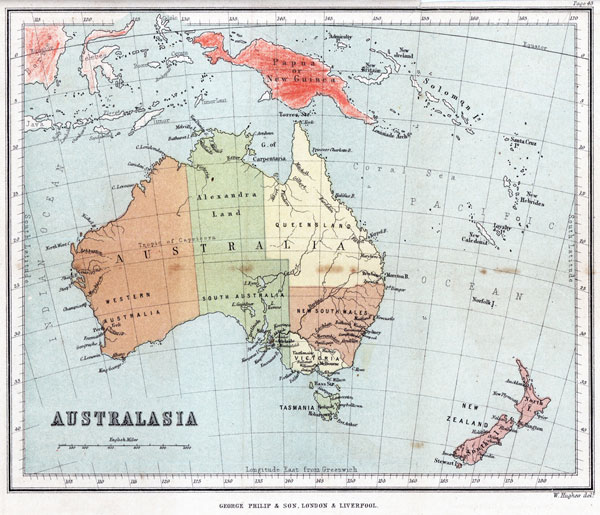
New Zealand forms a part of that extensive and important division of the world's surface situated in the South Pacific Ocean, and called Australasia, which consists of the large island or continent of Australia, with the island of Tasmania immediately to the south, and a belt of islands and island groups encircling it on its northern and eastern sides.
The most northerly island of this belt, which is included within the Australasian division, is the large island called. Papua, or New Guinea, and the most southerly portion is the New Zealand group.
The other most considerable islands and groups, commencing with Papua, are the Admiralty Islands, New Britain, New Ireland, the Salomon Islands, the Louisiade Archipelago, the Santa Cruz group, the New Hebrides, the Loyalty Islands, and New Caledonia.
Of these islands Australia, Tasmania, New Zealand, and the small Norfolk Island, lying between New Zealand and New Caledonia, and attached to the government of New South Wales, form portions of the British Empire, whilst New Caledonia belongs to the French. The remaining islands are still in the possession of native tribes, some of whom are Malay, but the greater part are negro races.
Australia is a very large and important country, not much inferior in size to Europe. It possesses a healthy climate, fertile soil, and valuable minerals.
As the northern extremity of Australia stretches to within eleven degrees of the equator, its climate and temperature are very various in different parts of its continent. The temperature in the north is tropical, and
[Image of page 44]
that in the southern parts, where most of the British colonies are situated, is similar to that of the southern countries of Europe. It suffers, however, occasionally from a dry, hot wind (the Australian sirocco), blowing from the interior during the extreme heats of summer.
It comprises five British Colonies,--New South Wales, the oldest settlement, occupying the central portion of its eastern division; above this, Queensland, extending to the northern coast, and containing extensive tracts of fertile land, adapted for the cultivation of tobacco, cotton, and sugar cane; and below it, Victoria, the El Dorado of the East, with the smallest extent of territory, but the largest population, of any of the Australian colonies. South Australia occupies the southern portion of the central division, the northern part of which, named Alexandra Land, is still uncolonized, though several attempts at settlement have been made, and a site for a town called Palmerston lately selected on the northern coast.
The remaining portion of the country is called Western Australia, and though possessing a territory equal to one third of the whole island, contains at present a very limited population.
The greater portion of the interior of Australia remains still unexplored, and is sparsely inhabited by a black race called the Australian Negroes. The colonial settlements seldom extend beyond 200 miles from the coast.
The principal cities and towns are--in New South Wales, Sydney, Paramatta, Liverpool, Campbelltown, Goulburn, Newcastle, and Maitland, near the coast, with Windsor and Bathurst in the interior; in Victoria--Melbourne, Williamstown, Belfast, Alberton, Geelong, and Portland on the coast, with Ballarat and Castlemaine in the interior; in Queensland--Brisbane, Ipswich, and Maryborough; in South Australia--Adelaide, Port Adelaide, Glenelg, Macclesfield, Kooringa, Gawler, Hansdorf, Port Lincoln, and Kingscote; and in Western Australia--Perth, Fremantle, Guilford, York, and Albany.
[Image of page 45]
Tasmania is a large island, immediately to the south of Australia, and only separated from it by Bass Strait. It is nearly as large as the North Island of New Zealand, and contains a flourishing British Colony. Its chief towns are Hobart Town, Launceston, George Town, Port Arthur, Campbell Town, Oatlands, Green Pond, and Richmond.
Papua, or New Guinea, is one of the largest islands in the world after Australia. It has a tropical climate, and very fertile soil, but its inhabitants are uncivilized and very barbarous. They belong mostly to the Papuan race, which also inhabits the other islands of the belt, with the exception of New Zealand, and, from their resemblance to the black tribes of interior Africa, are called Negroes, but are more savage and less intelligent than the African Negroes.
New Caledonia is a large island, 200 miles long and 26 miles in breadth, and is traversed throughout its length by a mountain range. It belongs to the French, who have established a permanent settlement upon its coasts.
QUESTIONS FOR EXAMINATION.
1. Of what large division does New Zealand form a part? 2. What does that division consist of? 3. Name the extreme northern (and southern islands of the belt? 4. Name the other most considerable islands and groups. 5. Which of the Australian islands belong to the British Empire? 6. To whom does New Caledonia belong? 7. Who possess the other islands? 8. Describe Australia. 9. Describe its climate and temperature. 10. From what wind does it peculiarly suffer? 11. How many British Colonies does it contain? 12. Describe the position of each. 13. What is known of the interior? 14. Name the principal towns of New South Wales. 15. Name those of Victoria. 16. Name those of Queensland. 17. Name those of South Australia. 18. Name those of Western Australia. 19. Describe Tasmania. 20. Name its chief towns. 21. Describe Papua. 22. By what race is it inhabited? 23. Describe New Caledonia.
[Page 46 is blank]