PART II. GEOGRAPHICAL DESCRIPTION OF THE PROVINCES OF NEW ZEALAND.
[Image of page 47]
PART II.
GEOGRAPHICAL DESCRIPTION
OF THE
PROVINCES OF NEW ZEALAND.
[Page 48 is blank]
[Image of page 49]
INTRODUCTORY CHAPTER
ON THE
GEOLOGICAL STRUCTURE
OF
NEW ZEALAND.
(COMMUNICATED BY JAMES HECTOR, ESQ., M.D., F.R.S.)
THE geological structure of New Zealand is very complicated; the principal formations which have been distinguished in other parts of the world being represented, among the rocks which occur in these islands.
A large proportion of the surface is occupied by mountain ranges, extending generally in the direction of the length of the island, those composed of granitic and schistose rocks being principally confined to the south-west district; while highly inclined and altered sedimentary rocks, belonging to the palaeozoic and lower mesozoic formations, occur in the northern district.
Surrounding these mountains, and occupying valleys which radiate from them, are horizontal and comparatively undisturbed sedimentary formations, belonging to the upper mesozoic and tertiary periods.
And lastly, certain areas, most extensive in the North
[Image of page 50]
Island, are occupied by volcanic rocks, the eruption of which commenced with the middle tertiary period, and was continued almost to recent times. Intrusive, igneous, and plutonic rocks, marking the period when the older formations were upheaved to form the mountain masses, are also exposed at the surface, and give rise to peculiar features, in certain limited districts characterised by the presence of metalliferous veins.
In describing the above formations we must consider, --first, the granitic rocks, in which group is included a variety of crystalline rocks, such as granite, gneiss, and porphyry, characterized by extreme hardness, and power of resisting mechanical degradation.
On the west coast of Otago these rocks form massive mountains, having an altitude of from 6,000 to 7,000 feet, containing profound valleys which afford the most impressive scenery in New Zealand. The valleys which open to the western side of the great mountain-chain are occupied by fiords or sounds, remarkable for their great depth and precipitous sides; while those valleys on the east or interior side of the range are occupied in a similar manner by the ramifying arms of great fresh-water lakes, the depth of which is generally found to exceed the altitude of the surface of the lake above the sea-level.
This district is the most ancient part of New Zealand, the crystalline rocks of which it is composed having received their present mineral structure when buried at a great depth in the earth's crust, and being afterwards exposed at the surface by the denudation of an enormous thickness of overlying formations, as they were gradually upheaved to the position which they at present occupy with respect to the level of the ocean.
[Image of page 51]
Granitic rocks also occupy the greater part of Stewart Island, and occur at intervals along the west coast as far north as Cook Strait, but are wholly wanting in the North Island.
Secondly:--Schistose rocks, in which the same minerals occur as in granite, and which are arranged in very distinct layers, presenting a soft and yielding structure, occupy a very large area in the central and eastern districts of the Otago Province, and extend as a narrow strip northwards along the western slope of the South Island, lying in contact with, and to the eastward of, the crystalline rocks. It is from this formation that a large proportion of the gold found in New Zealand is supposed to be derived.
Thirdly:--Overlying the schistose rocks, and rising as highly inclined strata to form the highest mountain peaks which occur in these islands, is a vast thickness of slates, shales, and sandstones, principally of palaeozoic age, as proved by the fossils of Silurian, Devonian, and Carboniferous age, which they have been found to contain in a few localities. In the North Island these are the oldest rocks which have been found in the mountain ranges, neither the schistose nor crystalline rocks reaching the surface. Sandstones, shales, and limestones, equally disturbed with the foregoing, but containing fossils which have referred to the Triassic period, are also found in several localities to form parts of the mountain chains.
The principal development of this group of rocks is found in that portion of the Southern Alps which culminates in Mount Cook, and may be considered as extending from the north-east part of the Province of Otago, where they are represented by the Kakanui Mountains, in a
[Image of page 52]
curved direction to Cook Strait, terminating in the rugged district between Blind Bay and the Wairau Valley. The newer portion of the series is found largely represented in the north part of the province of Southland, where it forms the Takatimo, and Dome and Eyre mountains. The same formation occupies the district west of the Wakatipu Lake, forming a narrow band intervening between the schistose and crystalline rocks. On the eastward slope of the New Zealand Alps, this newer slate series forms subordinate ranges, skirting the great Canterbury Plains, and reaching their greatest altitude in the Kaikorai Mountains. In the North Island the older rocks are found principally in the eastern districts, forming the Rimutaka, Tararua, Ruahine, Kaimanawha, and Kaingaroa ranges, which are all portions of that great geological range or axis. Parallel to these ranges, but farther to the north-west, are a succession of ridges, each formed by an axis of the older rocks, terminating in Capes Colville, Brett, Karakara, and North Cape. And, lastly, an axis occurs, dividing the volcanic district of the Waikato from the west coast, which extends as far south as between the Waikato and the Mokau Rivers.
These ridges are composed partly of old, partly of newer portions of the series, the latter predominating.
The above-mentioned rocks in all parts of New Zealand constitute the framework of the country, on which the newer, and less disturbed formations rest, indicating that a break in the geological series must have taken place at the close of the Triassic period on this part of the earth's surface.
The newer formations which are represented in New
[Image of page 53]
Zealand since that period may be enumerated as follows:--At Kawhia, on the western coast of the North Island, and at various places in the South Island, both on the east and west coasts, there occur patches of greensands and clays, containing fossils belonging to the Jurassic period, and resting on strata containing small seams of coal and impressions of vegetation.
Secondly:--A group of strata, consisting at the base of sandstones and shales,--associated with thick and valuable coal-seams, overlaid by Septaria clays abounding with iron, which again pass into calcareous marls and pure limestones,--constitutes a formation, the fossils in which are partly mesozoic and partly tertiary; in their character corresponding to the formations in the northern hemisphere which occur between the Wealden and the close of the Eocene period.
The coal formations on the Buller and Grey rivers, on the western coast of the South Island, and the south of Otago, also on the Waikato, and rivers at the Bay of Islands, belong to this series of strata; and indications exist of its occurrence in many other parts of the island.
Thirdly:--In almost every part of New Zealand depressions in the framework rocks which have already been described are occupied by sands and clays of fluviatile and sometimes estuarine origin, containing seams of brown coal of very considerable thickness and value. In the interior districts of the South Island this brown coal formation is covered directly by great deposits of rolled alluvium; but round the seaboard, and especially on the eastern coast of the South Island, and on the west coast of the North Island, the succeeding formation comprises i series of limestones and sandstones, abounding in fossils
[Image of page 54]
belonging to the Miocene period, constituting what is termed the Ototara or Waingaroa series, from localities where they have been particularly described.
A still newer tertiary formation, only slightly developed in the South Island as the Awatere series, but occupying more than a fourth of the area of the North Island, where it is known as the Hawke Bay and Whanganui series, represents in New Zealand the formations belonging to the Pliocene period.
Fourthly:--Post-tertiary sands and gravels, forming terraces along the courses of the rivers, and fringing the coast. Occasionally these gravels cover ancient forests, which in some cases are shown by sections on the sea coast to be submerged below the present sea level.
Associated with these are the remains of the Moa, and other gigantic birds of New Zealand, which did not exist in the country previous to the period during which these formations were deposited, and the bones of which are found mixed in the latest beds with works of human art.
The igneous rocks of New Zealand belong to three distinct groups.
First:--Those which are termed plutonic, and which were injected among the strata when deeply buried in the earth's crust,--comprising Sienites, Diorites, and Felstones, with many subordinate varieties of these rocks, distinguished by their chemical composition,--are found principally along the west coast of the South Island; and especially in what is termed the mineral belt, the best known development of which occurs at the Dan Mountain, in the vicinity of Nelson, where indications of a great variety of metalliferous ores and other minerals of
[Image of page 55]
interest and value have been discovered. The rocks of this series have been exposed along the eastern base of the mountains, and especially on the Kaikorai ranges, and in the North Island at several localities, of which Colville Peninsula and the Great Barrier Island are best known, from their having yielded a considerable quantity of valuable minerals and ores.
Secondly:--The volcanic rocks proper are divided into two groups, namely:--
(a.) The doleritic series, which in several instances, such as the Otago and Banks Peninsulas, appear to have been the result of submarine volcanic eruptions.
(b.) The newer volcanic formations, consisting of basalt, trachytic lava, obsidian, pumice, &c., the products of eruptions from cones with opened and unopened tops, and distinct lava streams. This series is extensively developed in the North Island, where are two active volcanoes, Tongariro, 6,500 feet high, and Whakari, or White Island, 863 feet, with numerous extinct volcanoes,--among them the highest peak of North Island, Ruapehu, capped with perpetual snow, being about 10,000 feet high.
Near Mount Tongariro, and around Lake Taupo, are numerous hot springs, boiling mud-pools, solfataras, and fumaroles; with deposits of silicious incrustations, alum, gypsum, and sulphur.
Besides this district, termed the Taupo zone, there are several others in the North Island belonging to this formation. The Taranaki District, with Mount Egmont (8270 feet), an extinct trachytic volcano;--Auckland zone, of basaltic lava formation, upon the Isthmus of Auckland, with 63 points of eruption, all extinct;--Bay of Islands zone, between Hokianga Harbour and Bay of Islands,
[Image of page 56]
basaltic lava formation, as on the Isthmus of Auckland; and a number of small extinct cinder-cones, from which basaltic lava streams have issued.
Upon the South Island:--Basaltic and doleritic cones, with lava streams, at the eastern foot of the Southern Alps, among the Malvern Hills--province of Canterbury. Palagonite tuff at the foot of Mount Somers. Portions of the volcanic system of Banks Peninsula, for example, the basalt eruptions of Quail Island,
Like all islands in the south seas, New Zealand is occasionally visited by earthquakes, but there is no proof that they are of local origin, it being more probable that they are merely shocks produced, by more or less distant eruptions in the bed of the Pacific Ocean; and manifested indirectly by encountering fractured and dislocated portions of the earth's crust, where the more deep-seated strata have been thrust to the surface.
[Inserted unpaginated illustration]
[Image of page 57]
GEOGRAPHICAL DESCRIPTION.
SECTION I.
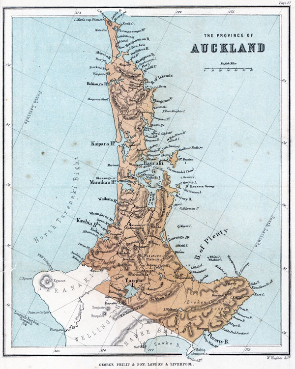
THE PROVINCE OF AUCKLAND.
SYNOPSIS.
TOWNS. Chief,--City of Auckland. Secondary,-- Mangonui, Russell, Whangarei, Onehunga, Drury, Raglan, Shortland, Tapu, Tauranga, Mangawai, Matakohi, Orua-wharo, Albert-town, Mahurangi, Otahuhu, Panmure, Howick, Coromandel, Waikato, Newcastle or Ngaruawahia, Hamilton, Cambridge, Alexandra, Opotiki, Turanga.
BAYS AND HARBOURS. Hauraki Gulf, North Taranaki Bight, Frith of Thames, Ahaipara Bay, Hokianga Harbour, Kaipara Harbour, Manukau Harbour, Waikato Heads, Whangaroa Harbour, Aotea Harbour, Kawhia Harbour, Rangaounou and Doubtless Bays, Bay of Islands, Whangarei Bay and Harbour, Waitemata or Auckland Harbour, Coromandel Harbour, Mercury Bay, Bay of Plenty, Tauranga Harbour, Hicks Bay, Kawakawa Roads, Tokomarua Bay, Tolago Bay, and Poverty Bay.
CAPES. Te Rua, and Albatross Points; Manukau Heads, Kaipara Heads, Reef Point, Cape Maria Van Diemen, Cape Reinga, North Cape, Capes Karakara and Brett, Bream Head, Capes Colville and Aiguilles or Needle Point, Cape Runaway, East Cape, Gable-end Foreland, and Young Nicks Head.
ISLANDS. Stephenson, Flat, Three Kings, Cavallis, Moturoa, Poor Knights, Maro Tiri, Moko Hinou, Final,
[Image of page 58]
Taranga, Great Barrier, Little Barrier, Selwyn, Broken, Kawau, Rangitoto, Rakino, Waiheki, Ponui, Cuvier, Great Mercury, Red Mercury, Kawitihu, Korapuki, Aldermen, Shoe, Mayor, Motiti, Whale and White Island, or Whakaari.
MOUNTAINS. Ranges,--Kai Manawha, Te Whaiti, Coromandel, Wairoa, Pateroa, Pakaroa.
PEAKS. Maungataniwha, 2,150 feet; Mangonui, 2,046; Edgecumbe, 2,575; Hardy, 3,700; Ikurangi, 5,535; Karehoe, 2,370; Pironghia, 2,800; Whariorino, 2,074; Rangitoto, 2,600; Tahataakiri, 3,500; Pihanga, 3,200; Kakaramea, 2,900; Kuharua, 2,800; Karangahape, 2,200; Tauhara, 3,000.
PLAINS. Upper and Lower Waikato basins, Thames Valley, Auckland district, Albertland, Kaingaroa, Patetere and Taupo plateaux.
LAKES. Taupo, Tarawera, Rotomahana, Rotorua, Rotoiti, Waikari, Wangape, Wahi.
RIVERS. Mokau, Waikato with its tributary Waipa, Wairoa, Piako with its tributary Waitoa, Waiho or Thames, Whakatane, and Waikari.
STATISTICS.
Area,--17,000,000 acres.
Population of Province (British) ....... 48,321
" " (Native)....... 23,000[?]
Total .............. 71,321[?]
Population of City of Auckland......... 11,153
Parnell......... 3,286
Newton......... 3,227
Onehunga......... 2,177
Shortland......... 1,000
Howick......... 640
Otahuhu......... 552
[Image of page 59]
The Province of Auckland.
The Province of Auckland contains that portion of the North Island of New Zealand in which British colonists first effected a settlement, the missionaries and their followers having obtained possession of tracts of country in the neighbourhood of the Bay of Islands as early as the year 1820.
The City of Auckland, situated on the Waitemata Harbour, on the eastern coast, became the seat of government and military capital of the colony in the year 1840, being named by the first governor, Captain Hobson, in honour of Lord Auckland. But the boundaries of the province were first defined--together with those of the provinces of New Plymouth, Wellington, Nelson, Canterbury, and Otago--under the New Zealand Constitution Act, in the year 1852, when a representative political constitution was bestowed upon the colony by the British Parliament, and the entire territory was divided into six provinces.
The Province of Auckland occupies about one half of the northern island, including all that lies north of the three provinces of Wellington, Taranaki, and Hawke Bay, and is separated from Wellington and Hawke Bay by the 39th parallel of latitude, and from Taranaki by the Mokau River and by that portion of the Whanganui which is north of the 39th parallel of latitude.
This tract of country is nearly severed about the middle of its length into two very unequal portions, by the near approach of the Waitemata Harbour on the east, and the Manukau Harbour on the west, the inner waters of which harbours leave only a narrow strip of land, called "The Isthmus of Auckland," between them, which in some places is less than half a mile in width, and sufficiently low for the easy portage and transhipment of goods from one of these harbours to the other, and which was frequently used by the natives for the more rapid transfer of their canoes from one coast of the island to the other.
[Image of page 60]
For the purpose of geographical description, this province may be conveniently divided into four principal portions:--1. The long and narrow peninsula to the north of the Isthmus of Auckland. 2. The Isthmus of Auckland, with the country immediately to the south, as far as the mouths or estuaries of the two large rivers Waikato on the western coast, and Waiho or Thames on the eastern. 3. The basins of the Waikato and Thames rivers, together with the Coromandel Peninsula, a projection commencing on the eastern side of the Thames estuary, and stretching parallel with the large peninsula already mentioned towards the north, but not so long; and also a tract known as the Lake District, lying to the east of the Thames Valley, and bounded itself on the east by the Kaimanawha and Te Whaiti ranges. 4. The country to the east of these ranges. Each of these portions will be briefly described, but we will first make a hasty survey of the entire coast-line of the province.
Commencing from the mouth of the river Mokau, its south-western boundary, which empties itself into the North Taranaki Bight, and directing our course towards the north, we observe about half way to Kawhia harbour a bold promontory called Te Rua Point, 400 feet in height. On approaching Kawhia Bay, in which are situated the two harbours of Kawhia and Aotea, Albatross Point, the southern headland of that bay, stretches out a long distance into the sea. Passing these harbours, and rounding Waipapa Point at the foot of Mount Karehoe, an extinct crater, 2,372 feet in height, we reach the harbour of Whaingaroa, with the town of Raglan on its southern shore; and pursuing our course northwards for the most part along a hilly coast, consisting of sandstone cliffs of moderate height, a straight reach of some 30 miles brings us to the Waikato Heads, where is a town and port at which vessels can anchor within half a cable's length of the beach.
After another similar but shorter reach, we arrive at
[Image of page 61]
the Manukau Harbour, the entrance to which is narrow, but the harbour itself occupies a very considerable area, generally shallow, but with deep channels, upon one of which the town of Onehunga is built. From Manukau our course lies along a sandy beach until we reach Kaipara Harbour, which is bordered by fine forests of Kauri pine. There is no other break in the coast until we reach the entrance to Hokianga Harbour, but Mount Mangonui is visible on the coast; and shortly after passing this we reach Reef Point, the southern headland of Ahaipara Bay, which is a bold projecting promontory, affording considerable shelter to vessels, although no harbour exists upon this part of the coast. The distance from this point to Cape Maria Van Diemen, the north-western cape of the Island, is about 60 miles. The twin cape to Maria Van Diemen, a little more to the north, is Cape Reinga, the native name for the nether regions, or place of departed spirits, who were supposed by the natives to plunge from this cliff into the boiling surge below. About 40 miles to the north-west of Cape Maria Van Diemen are three rocky islets called the Three Kings' Islands, which are the most northerly land of the colony.
North Cape is situated at the eastern extremity of the short north coast, which does not exceed 30 miles in length. From North Cape our course is towards the south-east until we reach Cape Brett, and we pass in succession the harbours of Parengarenga, Rangaounou, Doubtless Harbour, Whangaroa, and the Bay of Islands. About midway in this course is the promontory of Cape Kara-kara, and about halfway between Cape Kara-kara and Cape Brett, are the Cavalli Islands, near the coast; whilst on the mainland may be seen the mountain Maungataniwha, upwards of 2000 feet in height. From Cape Brett our course is nearly south, and we pass Whangarei Harbour, in the northern corner of Bream Bay; of which bay the northern and southern head-lands are named respectively Bream Head and Bream Tail, and to the
[Image of page 62]
south of which is the Mangawai harbour and settlement. Leaving the islets called the Poor Knights on our left, and passing through a little archipelago of islands, our course takes us between Little Barrier Island and Cape Rodney, and we enter the Hauraki Gulf. Near the coast, at some little distance further south, lies the isle of Kawau, the property and favourite retreat of the late Governor of New Zealand, Sir George Grey.
A little further south is the singular peninsula or promontory of Whangaparaoa; and yet further south, at the entrance to the Waitemata harbour, the volcanic isle of Rangitoto, the first of a chain of islands extending as far as the entrance to the Frith of Thames, the largest of which is named Waiheke, and the last of the series Ponui. At the bottom of the Frith of Thames we find the mouths of two rivers, the Waitoa and Thames, near which are rich gold-fields; and then changing the direction of our course towards the north, we coast along the Coromandel Peninsula,--pass Shortland, a large though lately founded gold-field town, to the north of which also is Tapu, another offspring of the gold-fields, situated about half way to Coromandel harbour, where much fine Kauri timber still exists,--and bending round between Great Barrier Island and Cape Colville, we arrive at Mercury Island, so called by Captain Cook because of the observations there taken of the transit of the planet Mercury across the sun,-- which expected event, together with that of a transit of Venus, led indirectly to Cook's visit to the New Zealand Islands.
Then we again turn to the south, pass Mercury Bay, and entering the Bay of Plenty, leave the Aldermen islets and Mayor's Island on our left, and reach Tauranga Harbour;--the two last-named harbours being the last capacious harbours which we shall find upon this eastern side of the island. From hence our course is south, until having passed the island of Motiti and Whale Island, we arrive at the mouth of the river Whakatane, not far from
[Image of page 63]
which is Opotiki, rendered sadly memorable by the cruel murder of the Rev. Mr. Volkner by the natives in 1865. Opposite this, at about twenty-five miles from the coast, is Whakaari or White Island, containing a still active volcano, and the north-eastern extremity of the Kaimanawha and Te Whaiti chains, which extend in nearly a direct line from Mount Tongariro, in the middle of the island, to the coast. We have now in view the three remarkable peaks of Mount Edgecumbe, Mount Hardy, and Mount Ikurangi, the two latter of which are situated at a short distance from Cape Runaway and East Cape, between which lies the small Hicks Bay; after passing which we again turn to the south, and coast along an extensive tract of country at present very imperfectly explored, and nearly all of which remains in the hands of native tribes. Passing in succession, Open, Tokomarua, and Tolago Bays, together with Gable-end Foreland, we reach the settlement of Turanga, upon the Turanga-nui river, in Poverty Bay, about twenty miles north of the 39th parallel of latitude, where the province terminates.
Proceeding with a description of the several divisions of the country previously made:--
1st. The great northern peninsula, extending from the Isthmus of Auckland to the extreme north of the island, is about 200 miles in length, by an average of 35 or 40 in width, which latter however varies from 6 to 60 miles.
Its coast-line is very irregular, and is indented both on the east and west by a succession of deep inlets, forming several capacious harbours, the most important of which are the Bay of Islands and Rangaounou Bay on the east, and Hokianga and Kaipara Harbours on the west coast. The interior of this peninsula consists of broken and undulating country, of moderate height, seldom exceeding five or six hundred feet, with a few scattered summits of greater elevation, the principal of which are the Maungataniwha and Whangaruru Hills towards the eastern coast,
[Image of page 64]
and the Mangonui Bluff on the western coast, which attains an elevation of about 2,000 feet.
The largest river in this part is the Wairoa, rising in the Whangaruru Hills, and flowing across the island, until it empties itself into the Kaipara Harbour, forming the waters of the northern half of its basin, whilst the Kaipara River forms the southern portion. The country around the harbour is covered with dense bush, consisting in a great measure of the noble Kauri pine. The country further north is less thickly wooded, but contains patches of fine timber and others of fertile land, the most important of which are in the neighbourhood of Hokianga Harbour and the Bay of Islands. In the neighbourhood of Kaipara Harbour is the newly settled district of Albert Land, with the town and port of Alberton. The neighbourhood of the Bay of Islands is worthy of notice, as being the earliest settled portion of the colony. The principal British towns in this part of the island are Mangonui on Doubtless Bay, Russell on the Bay of Islands, and Whangarei on the harbour of that name.
2nd. The belt of land forming the portion of the peninsula to the south of the Isthmus of Auckland, including the site of the City of Auckland, is settled entirely by British colonists. Its natural advantages for settlement and commerce, with capacious and safe harbours equally accessible on both sides (in which respect it has been compared with ancient Corinth), induced the British Government to select it, in the early days of New Zealand colonization, for the seat of government. The land in this part is broken and undulating, scattered over with conical hills, the craters of extinct volcanoes, the debris of which adds greatly to the fertility of the soil.
The City of Auckland is situated immediately upon the isthmus on the south shore of the Waitemata Harbour and the villages of Parnell, Newmarket, and Newton, once distinct settlements, now form suburbs contiguous to the city. About six miles from Auckland, but on the
[Image of page 65]
opposite coast, and on the northern shore of Manukau Harbour, are Onehunga and Otahuhu, whilst on the southern shore of the same harbour is situated the smaller town or village of Drury.
3rd. The basins of the Waikato and Thames rivers comprise probably the most extensive and fertile tracts of agricultural country in the island, extending in length from the southern boundary of the province to the Frith of Thames, and being about 50 miles wide. The valley of the Waikato is formed by a range of hills running parallel with the west coast, at a distance from that coast of from 10 to 20 miles, and on the east by the Pakeroa Mountains, which divide its basin from that of the Piako, and towards its source by the Te Whaiti and Kaimanawha ranges. The river takes its rise in the Wellington province, on the slopes of Mount Ruapehu; it flows through and supplies the waters of the remarkable lake Taupo, near the centre of the island, which is 25 miles long, and 20 miles in its greatest breadth,--its elevation above the sea level being 1,250 feet. Twenty miles south-west of this lake stands the active volcano Tongariro, and in the surrounding country are numerous hot springs and geysers,--remarkable features in this beautiful and interesting district; whilst round about it stand a number of remarkable peaks, among which we may enumerate Pihanga, Kakaramea, Kuharua, Karangahape, Tauhara, and Tahataakiri. The Waikato river flows out of the north-eastern corner of this lake, and runs in a northerly direction through a very fertile valley for about 100 miles, when it is joined by the Waipa, which is also a considerable stream rising in the Rangitoto Mountains, and having a course almost due north of about 50 miles. From its junction with the Waipa to the sea coast, a course of about 50 miles, the Waikato is navigable for small vessels. After its junction, it flows due north for a distance of about 20 miles, when, its course being obstructed by the southern extremity of the Wairoa
[Image of page 66]
ranges, it suddenly makes a rectangular bend towards the west, at about the same distance from its outlet on that coast. The valley of the Waikato has been long occupied by one of the most numerous and warlike of the native tribes, who possess several strong and well-selected posts upon its banks, and it was the site of the principal conflicts between General Cameron and the natives.
The strip of country lying between the western hills and the west coast is also of some importance, on account of the harbours of Aotea, Kawhia, and Whaingaroa; the cliffs of which harbours consist of limestone, and in the neighbourhood of which there is some extent of fertile land.
On Whaingaroa Harbour is situated the town of Raglan. Near Kawhia Harbour is Mount Pironghia, 2,300 feet in height; and near Te Rua Point is Mount Whariorino, 2,074 feet.
The valley of the Thames, including the valley of the Waitoa, which, with its tributary the Piako, flows in a parallel course at a distance of only five or ten miles, consists entirely of native territory, and occupies an area of fine country, much of which is heavily timbered. These rivers take their rise in the middle Waikato basin, and their valleys are bounded on the western side by the Pakaroa range, and on the east by table-land, and by a southern continuation of the Coromandel Mountains. The Thames has a course of about 50 miles, and is navigable for some distance by small vessels. It empties itself, together with its neighbour the Waitoa, into the Frith of Thames, at the bottom of the Hauraki Gulf. Near the mouth of this river, on the sea coast, are the Thames gold diggings, which have lately risen into considerable importance, from the large quantity of gold extracted from the reefs. The principal town connected with these diggings is Shortland, but only a very small portion of the surrounding country is in the possession of the New Zealand Government.
The Coromandel peninsula is a continuation of the gold-
[Image of page 67]
bearing range of hills which form the eastern boundary of the Thames Valley. The length of the peninsula is about 80 miles, and it is almost entirely occupied by the Coromandel Mountains. The harbours of Coromandel on the western side, and Mercury Bay on the east, afford good shelter for vessels of moderate size.
The "lake district," which extends from Lake Taupo to the coast, and from the Thames Valley to the Te Whaiti Mountains, is a country full of marvels, which will ever attract and repay the notice of adventurous travellers. It is thus referred to by Dr. Hochstetter in his "Geology of New Zealand:"--"The distance from Tongariro to the Whakaari volcano (White Island) is 120 nautical miles. Over this whole distance, almost on the very line between these two active craters, it seethes and bubbles and steams from more than a thousand crevices and fissures that channel the lava-beds of which the soil consists,--a sure prognostic of the still smouldering fire in the depths below; while numerous fresh-water lakes, of which Lake Taupo, 20 miles in diameter, is the largest, fill up the large depressions of the ground. This is 'the lake district' so famous for its boiling springs, its steaming fumaroles, solfataras and bubbling mud-basins, or, as the natives call them, the Ngawhas and Puias. Till now none but missionaries, government officers, and some few tourists have ventured by the narrow Maori paths through bush and swamps to visit this marvellous region; but all who have witnessed with their own eyes the wonders of nature displayed here were transported with amazement and delight. Only the natives have hitherto made practical use of these hot springs, which are the grandest in the world, and sought relief in them for their various complaints and diseases. But when once, with the progressive cultivation of New Zealand, these parts have become more accessible,--then thousands dwelling in the various countries of the Southern Hemisphere, in Australia, Tasmania, or New Zealand, will flock to these
[Image of page 68]
parts, where nature not only exhibits such remarkable phenomena in the loveliest district, with the best and most genial climate, but has also created such an extraordinary number of healing springs."
The easiest approach to this interesting district is from Tauranga Harbour, an extensive and sheltered inlet in the Bay of Plenty; and although the whole line of country from Taupo to within a few miles of the coast is lined with springs emitting columns of steam and boiling water, the nearest of the larger lakes are situated within 40 miles of that harbour. Tarawera is the largest and most beautiful of these lakes, lying at the foot of Mount Tarawera (2000 feet high); but the most marvellous lake is Rotomahana, or "Hot Lake," fed by boiling siliceous springs which keep the whole of its water at a high temperature, and deposit an enamel-like white siliceous crust or coating over the whole margin of the lake, giving the whole region a fantastic and fairyland-like appearance. These springs are generally intermittent, and the largest of them exceeds in extent and power the "Great Geyser" of Iceland. In the vicinity of the hot springs food is ordinarily cooked, without fire, by placing it in one of the numerous open fissures from which steam is escaping. Rotorua and Rotoiti are two other neighbouring lakes of singular interest and beauty, and towards the north east of the district stands the well developed cone of Mount Edgecumbe. Similar phenomena to those of the lake district are also found in the neighbouring islands, called Whale Island and White Island, in the adjacent bay.
4th. The remaining division is that of the country lying east of the Te Whaiti and Kai Manawha ranges, and comprises that portion of the island of which least is at present known. It is called the East Cape country, and consists of rugged land with high mountains in the interior, and some considerable streams. At its northern extremity are a group of conical peaks, of which Mounts
[Image of page 69]
Hardy and Ikurangi are particularly prominent. The interior is occupied by a warlike and hostile mountain tribe, the Uriwera; and the coast by more friendly tribes, the Arawa and Ngatipouri Church Mission stations have been established in several parts, and the see of the Native Bishopric is at Waiapu, on the north-east coast. There are numerous bays and small harbours upon the coast; and small settlements have been effected at Opotiki in the Bay of Plenty, as well as at Turanga in Poverty Bay, which is the principal harbour on the coast, and was the first land visited by Captain Cook,--Young Nick's Head, its southern headland, being so named by Cook after Nicholas Young, the sailor lad who first descried the land. In the interior is Lake Waikari, from which a river of the same name and of considerable magnitude flows into Hawke Bay.
The province of Auckland, from its great extent and varied resources, no less than from its early settlement and large population, forms one of the most important divisions of the colony. The city occupies a position admirably adapted for an extensive commerce, and the great length of coast, with the numerous harbours of the province, have furnished sites for a greater number of thriving towns than any other part of the colony. The area of the province is about 17,000,000 acres, and its population (British) 48,321. The population of the City of Auckland is 11,153; that of its suburbs, Parnell and Newton, 3,226 and 3,227 respectively. Onehunga contains 2,177, Howick 640, and Otahuhu 552, whilst the goldfield town of Shortland contains probably upwards of 1000. The natives in the province number about 25,000, and belong chiefly to the Ngapuhi, Waikato, Arawa, Ngatipouri, and Uriwera tribes.
[Image of page 70]
SECTION II.
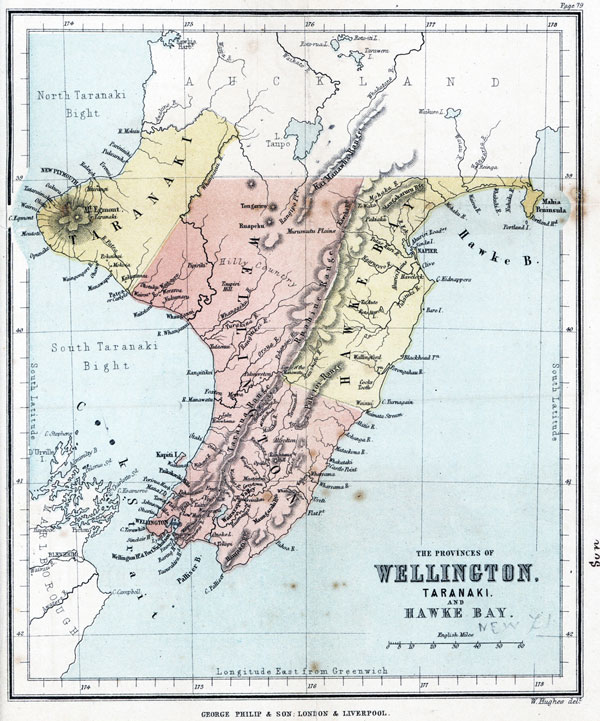
PROVINCE OF TARANAKI.
SYNOPSIS.
TOWNS. Chief,--New Plymouth. Secondary,--Patea (Carlyle), Waitara (Raleigh).
VILLAGES AND DISTRICTS. Hua, Urenui, Oakura, Tataraimaka, Okato, Pukearuhi, Tikorangi, Huirangi.
BAYS. North and South Taranaki Bight, Opunake.
HARBOURS. Taranaki Roadstead.
CAPES. Cape Egmont, Parininihi or White Bluff.
ISLANDS. Sugar Loaf Islands.
MOUNTAINS. Ranges,--Ponakai, Patua. Peaks,--Mount Egmont or Taranaki, 8280 feet.
RIVERS. Mokau, Patea, Waitara, Urenui.
PLAINS. Waimate.
STATISTICS.
Area of Province,--2,137,000 acres.
Population of Province (British) ............... 4, 359
" " (Native) ............... 3,000
Total.....................7,359
Population of chief town, New Plymouth...[?]
THE PROVINCE OF TARANAKI.
This province originated in the settlement of New Plymouth, which was founded by the "Plymouth Company of New Zealand," in conjunction with the "New Zealand Company," in the year 1841; and the town of New Plymouth, then founded (and which until quite recently has continued to be the only centre of population in the province), still forms its chief town.
[Image of page 71]
The boundaries of the province were defined by proclamation, under the Constitution Act of the colony, in the year 1852; but it was at that time described as the province of "New Plymouth," which name was changed to "Taranaki" by act of the General Assembly of New Zealand, in the year 1858.
The province of Taranaki consists of the western projection of the North Island, and is divided at the coast from the Auckland province to the north by the River Mokau, and from the Wellington province to the south by the River Patea. The River Mokau also forms its northern boundary line; its eastern boundary consisting, in part, of the north-easterly bend of the River Whanganui, and in part of two lines,--one of which unites this river to the River Mokau at its source, and the other to the River Patea at its mouth. In all other parts it faces the ocean.
The coast-line of this province is nearly unbroken by any considerable indentation. Starting from the mouth of the Patea and following the shore, which runs at first nearly in the direction of the snow-clad summit of Mount Egmont (the native name of which is Taranaki), we make a circuit towards the north-west, following, as we go round, the mountain's base,--the lava streams radiating from which have more effectually resisted the erosive action, or washing of the sea (so powerful on western coasts), than the softer clay cliffs to the north arid south of the promontory, which are rapidly yielding to its force.
Having reached the extreme westerly point of the province, Cape Egmont, distant about 55 miles in a direct line from the mouth of the Patea, the direction of the coast-line gradually turns until it assumes a general direction of E.N.E., which it preserves with slight deviations as far as Parininihi or White Bluff, a remarkable cliff, 850 feet in height, distant about 45 miles in a straight line from Cape Egmont.
[Image of page 72]
From White Bluff, the general direction of the coast as far as Whaingaroa Harbour, in the province of Auckland, is only a little to the eastward of north.
The town of New Plymouth is on the coast, almost half-way between Cape Egmont and White Bluff; and its position is well marked from the sea by a remarkable group of rocks lying within two miles of the shore, known as the Sugar Loaves. These rocks rise abruptly from the sea, but Paritutu, or the Sugar Loaf, a small rock, stands on a point of the mainland, and reaches a height of 504 feet. Several of these rocks are more or less peaked or dome-shaped, but Paritutu is particularly conical, and affords an unmistakeable land-mark for seamen.
The symmetrical cone of Mount Egmont, an extinct volcano (8280 feet), is a striking feature in the landscape from almost all parts of the province. This noble mountain stands in solitary grandeur in the centre of the rounded promontory before described, which forms the most westerly portion of the province. On all sides, for a distance of 15 miles or more, the general slope of the land is away from Mount Egmont, so that the courses of the numerous rapid rivers which reach the sea at different points on the coast-line of this promontory radiate from the mountain as a centre; and its sides curve off so gently and gracefully into the general slope of the country, that, viewed from a little distance from the shore, it appears to rise from the sea, whilst the inclination of the land is scarcely perceptible in travelling over it (except by the courses of the rivers) until within about five miles from the summit of the mountain.
On its north-west side this regular formation of the country is broken by two ranges, lying between Mount Egmont and the sea, called the Ponakai and Patua Ranges, about 4,000 and 5,000 feet in height respectively.
The greatest extent of level open land is in the southeastern part of the province, comprehending what are called the Waimate Plains, and this is separated by the
[Image of page 73]
south-eastern boundary line of the province from a similar tract of land in the province of Wellington.
Almost the whole of the open country in the province of Taranaki lies along the coast, forming a belt from the White Bluff to Patea River of an average width of four or five miles, and containing a number of thinly-peopled villages and districts, besides the town of New Plymouth. The remainder of the province is for the most part covered with forest, and large tracts are still quite unexplored; but most of the land is known to be level, and of good quality.
The soil of the whole district for many miles round Mount Egmont is of a very uniform character, the subsoil being derived from decomposed volcanic rocks, and the surface soil being of the same substance mixed with loam. This soil is well adapted for grapes and root crops, but is rather too light for wheat. In the Patea and Urenui districts, however, where marly beds reach the surface, a much stronger soil is obtained.
This province is destitute of any good harbour, a general characteristic of the south-west coast of the island. The safest anchorage for large vessels is in the roadstead of New Plymouth, which is partly sheltered from the prevailing winds by the Sugar Loaf Islands. There are other shipping places upon the coast, the best of which is in the small Bay of Opunake, half-way between New Plymouth and Patea.
At New Plymouth itself, the sandy beach, which consists chiefly of ironsand, furnishes a convenient landing place for the large cargo boats, by means of which all goods have to be landed and shipped. There are also four rivers in the province capable of receiving small vessels and steamers of light draught, namely, the Mokau, the Waitara, the Patea, and the Urenui, of which the Patea rises from Mount Egmont, and the Waitara and Urenui from the wooded slopes behind it, whilst the Mokau rises in the Rangitoto Mountains, near the source of the Waipa.
[Image of page 74]
The principal town is New Plymouth, situated on the Huatoki, a small and shallow mountain stream. Townships are also being formed at the mouths of the Patea and Waitara rivers, and there are several villages established in the blocks of land which have been given to military settlers; such are Hua, Urenui, Oakura, Tataraimaka, Okato, Pukearuhi, Tikorangi, and Huirangi. The township at the mouth of the river Patea has received the name of Carlyle, and that at the mouth of the Waitara the name of Raleigh, but they are still generally known by those of Patea and Waitara.
The Province of Taranaki has suffered more than any other portion of the colony by the late long-protracted native war; but from the general fertility of the soil, it is likely, sooner or later, to become one of the most populous districts of New Zealand. It also possesses a probable source of future wealth in the iron-sand which abounds upon its coast, and springs of petroleum have been found near the Sugar Loaves.
The area of the province is 2,137,000 acres, of which 150,000 belong to British settlers, 973,000 to Native tribes, and 1,014,000 to the Government.
The population in 1867 amounted to 4,359 British, and about 3,000 Maoris. The population of its chief town, New Plymouth, is 2,180.
The natives of Taranaki belong mostly to the Ngatiawa, Taranaki, and Ngatiruanui tribes.
SECTION III.
PROVINCE OF HAWKE BAY.
SYNOPSIS.
TOWNS. Chief,--Napier. Secondary,--Clive, Havelock, Hampden, Waipawa, Wallingford, and Porongahau.
VILLAGES AND DISTRICTS. Waipukerau, Meanee, Wairoa, Te Aute, Wainui, and Blackhead.
[Image of page 75]
BAYS. Hawke Bay.
HARBOURS. Napier, Wairoa, and Porongahau.
CAPES. Table Cape, Portland Head, Cape Kidnappers, Paoanui Head, Black Head, and Cape Turnagain.
ISLANDS. Portland Island and Bare Island.
PENINSULAS. Napier Peninsula or Scinde Island, and Mahia Peninsula.
LAKES. Roto a Taro, Whatimu, and Tutira.
MOUNTAINS. Ranges,--Ruahine, Kaweka, Mangahararuru, and Puketoi. Peaks,--Te Waka and Cook's Tooth.
RIVERS. Nuhaka, Wairoa, Mohaka, Esk, Tutaikuri, Ngaruroro, Tukituki, and Porongahau.
PLAINS. Ahuriri and Ruataniwha.
STATISTICS.
Area of Province,--2,840,000 acres.
Population of Province (British) ............... 5,283
" " (Native) ............... 3,000
Total.................. 8,283
Population of chief town, Napier ...............1,827
THE PROVINCE OF HAWKE BAY.
The present province of Hawke Bay was included within the original boundaries of the Wellington province, as proclaimed under the New Zealand Constitution Act; but was created a distinct province, under an Act of the General Assembly of New Zealand, in the year 1858.
It occupies, on the east of the North Island, an area only slightly exceeding that of Taranaki on the west, and is comprised within nearly the same parallels of latitude, a portion only of Hawke Bay province lying to the southward of Taranaki. In place, however, of the coast projection maintained by the solid mass of Mount Egmont, its coast forms a deep bay, which was named Hawke Bay by Captain Cook, after Sir Edward Hawke, who was then First Lord of the Admiralty.
[Image of page 76]
This province is defined from that of Auckland, towards the north, by the 39th parallel of latitude; and from that of Wellington, to the south, by the Waimata stream, and by a line drawn from its source in a north-westerly direction,--crossing the Puketoi mountains to the Manawatu gorge, at the southern end of the Ruahine range. Its western boundary is the crest of the Ruahine and Kaweka ranges, and an irregular line continued northwards to the 39th parallel of latitude.
The configuration of the coast-line of this province is irregular, and its general character rough and broken from Mahia peninsula to the neighbourhood of Napier. From thence to Cape Kidnappers it is open, but broken again from that cape to the river Waimata. Commencing at the south-eastern boundary, the mouth of the River Waimata, a little to the south of Cape Turnagain,--which is a bold headland, presenting lofty cliffs of impure chalk,--the direction of the coast is north-east, until it has rounded that promontory; and it then turns in a more northerly direction for a distance of 70 miles, passing the sandy bay which receives the Porongahau River, and a succession of steep cliffs, broken headlands, and small bays, to Cape Kidnappers, the southern headland of the bay from which the province takes its name.
Cape Kidnappers is a conspicuous limestone promontory, 900 feet in height, and a few miles to the south of the cape lies Bare Island.
From this point the coast curves in the form of a semicircle, following which our course carries us past the mouths of several rivers which pour their waters into the bay, such as the Tukituki, Ngaruroro, Tutaikuri, and Esk, in the more southern part, and the Mohaka, Wairoa, and Nuhaka, towards the north.
In the southern part of the bay is the roadstead of Ahuriri, with the harbour of Napier, on which is situated Napier, the chief town of the province.
The northern headland of Hawke Bay is formed by the
[Image of page 77]
Mahia peninsula, a triangular-shaped piece of land, rather rough to seaward, but containing some rich and moderately level land. It is about 1,100 feet in height, projecting towards the south, and having at a short distance from its southern extremity the small and rocky islet of Portland. From thence the coast takes a northerly direction, and consists of table-land and wooded slopes up to the 39th parallel of latitude, the northern boundary of the province.
The general geographical character of the country of Hawke Bay province is indicated by the position of the Ruahine Mountains, its western boundary, a lofty range averaging from 3,000 to 4,000 feet in height. From this range the land slopes towards the eastern coast of the island, in a tolerably regular and gradual decline, broken into valleys and low mountain-chains, drained by streams which have their sources among the Ruahine Mountains. The peaks most prominently presenting themselves to notice are Te Waka in the north-west, and Cook's Tooth in the south-east of the province. The rivers are of inconsiderable size, though some of them can be entered by vessels of small tonnage.
The most important of these are the Tutaikuri, discharging itself into Napier Harbour, on the mouth of which the town of Napier is built; the Ngaruroro, on which stands the town of Havelock, about six miles inland; the Tukituki, with the town of Clive at its mouth, and Hampden upon one of its branches; and the Porongahau, rising among; the Puketoi Mountains in the south, and having on its banks the towns of Porongahau and Wallingford.
In the northern part of the province are the Wairoa, Mohaka, and Nuhaka, of which the Wairoa is a navigable river.
On the right bank of the Tukituki, about midway between the coast and the summit of the mountains, is the Lake Whatimu, near the village of Waipukerau, and on the opposite side of the river are the Lake Roto a Taro,
[Image of page 78]
and some smaller lakes in the Te Aute district, not far from the town of Waipawa. On the upper part of the course of the same river is a considerable extent of flat land called the Ruataniwha plains, on which the town of Hampden is situated. And again, inland of Napier Harbour, at the back of the town, and on both banks of the Ngaruroro stream, are plains known as the Ahuriri plains, the south-eastern portion of which is occupied by the Meanee villages, which form suburbs to the town of Napier.
The town of Napier itself is situated on a remarkable little peninsula called Scinde Island, one square mile in extent, presenting limestone cliffs on three sides, and connected with the mainland by a long spit of shingle, enclosing large salt-water lagoons and swamps. Wainui and Blackhead are two small towns upon the coast, in the southern part of the province.
The climate of Hawke Bay may be characterised as dry; its geographical position, and the shelter afforded by the adjacent ranges, securing it from the excessive moisture which prevails in the western parts of the island. It possesses a large proportion of good pastoral and agricultural land, which is well watered, and on which vegetation flourishes in a remarkable degree to the sea shore,--in this respect affording a contrast to the western shore of the island, which is in general fringed with a belt of drifted sand-hills, two or three miles in width.
The character of the climate, and the favourable exposure afforded by the numerous terrace-like slopes, adapt this province for the future cultivation of the grape vine.
The hills abound in limestone, but no minerals of any value have as yet been discovered in the province. Its exports consist of wool, sheep, and cattle.
The area of the province is about 2,840,000 acres, of which 1,090,000 are the property of British settlers, and 1,300,000 belonging to the Native tribes, whilst 450,000 acres are in the hands of the Government for sale.
[Inserted unpaginated illustration]
[Image of page 79]
The population in 1867 amounted to 5,283 British and about 3,000 natives. The population of Napier, the chief town, 1,827.
The natives of Hawke Bay province belong to the Arawa tribe; and, notwithstanding having parted with much of their land, are well provided for, and receive annually a large rental for lands leased to sheep farmers.
SECTION IV.
PROVINCE OF WELLINGTON.
SYNOPSIS.
TOWNS. Chief,--Wellington, Whanganui. Secondary,--(including villages and districts) Hutt, Porirua, Pahautanui, Featherston, Greyton, Carterton, Masterton, Alfred-ton, Turakina, Tutaenui, Rangitikei, Foxton, Palmerston, Otaki, Waitara.
BAYS. Palliser Bay, Porirua Bay, Fitzroy Bay, and South Taranaki Bight.
HARBOURS. Port Nicholson or Wellington Harbour, Whanganui River, Porirua Harbour.
CAPES. Terawhiti, Sinclair Head, Baring Head, Taourakira Head, Cape Palliser, Castle Point, Flat Point.
ISLANDS. Kapiti, Mana, Somes.
LAKES. Wairarapa, Onoke, Horowhenua, Westmere.
MOUNTAINS. Ranges,--Ruahine, Tararua, Rimutaka, Kai Manawha, Puketoi, Maungaraki, Haurangi. Peaks,--Tongariro (6,500), Ruapehu (9,195), Rangitumu Hill.
PLAINS. Wairarapa, Patea, Murimutu, Rangipo, and extensive undulating country bordering the South Taranaki Bight.
RIVERS. Whanganui, Rangitikei, Manawatu (with its tributaries Tokumaru, Oroua, Pohangina, Mongohao, Mahakahi, and Teraumea), Ruamahanga (with its tributaries Waiohine, Waingawa, and Taneru), Whareama,
[Image of page 80]
Patea, Waitotara, Whangaihu, Turakina, Otaki, Waikanae, Hutt, Pahoa, Whakataki, Mataekona, Aohanga, Ahitio, Waimata.
STATISTICS.
Area of Province,--7,000,000 acres.
Population of Province (British)......... 21,000[?] " " (Native)............... 4,000
Total .................. 25,000[?]
Population of chief towns, Wellington..... 7,469[?]
" " Whanganui......... 2,157[?]
THE PROVINCE OF WELLINGTON.
The Wellington province originated in a settlement established by the New Zealand Company in the year 1841, as the first and chief of their intended settlements in New Zealand. In 1852 it was proclaimed a province under the New Zealand Constitution Act, and its boundaries were at the same time defined. These boundaries originally included the present Hawke Bay province, which, however, was proclaimed a separate province, under an Act of the General Assembly of New Zealand, in the year 1858.
The province of Wellington, therefore, may be now described as comprehending all that portion of the North Island which is not included within the provinces of Auckland, Taranaki, or Hawke Bay, and is separated from Auckland, on the north, by the 39th parallel of south latitude; from Taranaki, on the north-west, by the north-easterly bend of the Whanganui River, and by a line reaching from the southern angle of that bend to the mouth of the River Patea; and from Hawke Bay, on the east, by a line in the direction of the crest of the Ruahine Mountains, reaching from the 39th parallel of latitude to their southern extremity at the Manawatu
[Image of page 81]
gorge; and from the same province on the south by a line from the same point to the mouth of the Waimata River, crossing on its way the Puketoi Hills. The southern extremity of the province is separated by Cook Strait from the north-eastern portions of the Marlborough province, in the South Island.
The coast-line of this province consists of three principal portions:--First, the west coast-line, extending from the Patea River on the north to Cape Terawhiti on the south; secondly, the south coast-line, extending from Cape Terawhiti eastwards to Cape Palliser; and thirdly, the east coast-line, extending from Cape Palliser northwards to the Waimata River. The eastern and western coast-lines are generally unbroken by any considerable irregularity; whilst that on the south is occupied by the fine harbour of Port Nicholson, and the extensive but less serviceable indentation of Palliser Bay. The western coast is bordered throughout by a fringe of sandy beach and drifted sand-hills, having a width in some parts of several miles; the beach affording an excellent natural road, which supplies for a distance of 100 miles a convenient means of communication between the city of Wellington and the important western districts of the province, whilst the shore on the south and east is generally rugged and rocky, and occasionally precipitous.
Commencing at the River Patea,--the southern boundary of the Taranaki province,--and following the coast-line towards the south, we find that it extends itself in a semi-circular bend to Cape Terawhiti, the south-western extremity of the island, forming the extensive South Taranaki Bight; in pursuing our course along which we pass a fertile belt of fine undulating country, averaging eight miles in width, containing the districts of Patea, Waitotara, and Kai Iwi, and extending along the coast for a distance of 30 miles, until we reach the mouth of the Whanganui River, the largest in the Wellington province, and navigable for vessels of light draught and about 30
[Image of page 82]
tons burden for 60 miles. Near its mouth is the flourishing town and port of Whanganui, the river admitting thus far vessels of about 12 feet draught. The town is symmetrically and conveniently built on the right bank of the river, and carries on, as the emporium of extensive pastoral and agricultural districts, an active commerce with the other commercial towns of New Zealand, and also with those of Australia.
From the mouth of this river the coast continues in a southerly direction, along a belt of similar undulating country, stretching far into the interior, and watered by the rivers Whangaihu, Turakina, and Rangitikei, the latter of which can be entered by small vessels. This extends along the coast for a distance of 50 miles, to the mouth of the river Manawatu, a stream navigable by light craft for about 50 miles from its mouth, near which is the town of Foxton.
From the Manawatu to the Paikakariki Hills is one continuous stretch for about 30 miles of similar country, skirted by a low sandy beach, broken only by the shallow outlets of the rivers Ohau, Otaki, and Waikanae, which water the belt of fertile undulating land lying between the Tararua Mountains and the coast. To the north of the Ohau, a smaller stream also empties itself into the South Taranaki Bight, after flowing through the Horowhenua lake, a fresh-water basin of small extent.
Nearly opposite to the mouth of the Waikanae, and about three miles from the coast, is the island of Kapiti, a steep hilly island, once a famous native stronghold, and subsequently a great whaling station, but now converted into a sheep and cattle run. Its area is about eight square miles.
The Paikakarika Hills are a spur from the main Tararua range, which approach to, and overhang, the shore; and from this point to Cape Terawhiti the coast is very rough and broken by similar spurs,--the principal of which has an abrupt termination at that cape. About midway
[Image of page 83]
between Kapiti and Cape Terawhiti lies the small bay and harbour of Porirua, with the village of Pahautanui; and off its entrance is the small island of Mana, on which a lighthouse has been erected.
The southern coast-line commences at Cape Terawhiti, and continues of the same rough and broken character round Sinclair Head,--the southern promontory of a steep, hilly peninsula, formed by the inlet to Wellington Harbour, and which affords it shelter from west and south-westerly gales. The opposite headland, on the eastern shore of the harbour, is Baring Head; a few miles from which is the bold cliff called Pencarrow Head, on the summit of which a lighthouse has been built, whilst another has been placed upon Somes Island, within the harbour. Port Nicholson, as this harbour is called, is about five square miles in extent, nearly landlocked, and securely sheltered on almost every side. The fine city of Wellington is built on the south-western shore of the inner bay, called Lambton Harbour.
Following the south coast-line from Baring Head, we continue along a steep and rugged shore, passing the mouths of the streams Wainuiomata and Orongorongo to Cape Taourakira,--the southern extremity of the great main range of mountains which, under the name of the Rimutaka chain, continue from the Tararua range to this headland. Rounding this cape, we enter Palliser Bay, a deep and extensive indentation, which receives on its northern shore, through the Wairarapa Lakes, the waters of a considerable stream--the Ruamahanga River--which drains the extensive and fertile valley of Wairarapa.
At Cape Palliser commences the east coast-line, which continues in a north-easterly direction along a line of rugged coast, with a hilly back country, for a distance of 88 miles; the most prominent point upon the coast being named Flat Point. We then pass the Whareama River, and reach Castle Point, a singular turret-like promontory, which affords a landing-place and convenient shelter for
[Image of page 84]
vessels from north-west gales, and near which a village is situated.
The remaining portion of the eastern coast is generally of a similar character with that just described, as far as the Waimata River, the north-eastern extremity of the province; but it is broken in succession by the mouths of the Rivers Mataekura, Aohanga, and Akitio,--all of which are streams of some magnitude.
In describing the internal geography of the province of Wellington, it will also be convenient to consider it in three divisions, nearly corresponding with the threefold division of the coast-line already made. The first division will be the north-western part of the province, comprehending all that lies to the north and west of the Tararua and Ruahine ranges. The second, the tract between the eastern coast and the Tararua and Rimutaka ranges. And the third, the south-west portion of the province, lying on the south and west sides of the same ranges.
The north-western portion, having for its eastern boundary the Ruahine and Tararua mountains, has a coast-line extending from the River Patea southwards to the bluff termination of the Paikakariki hills. It contains a belt of fertile undulating country, extending its entire length, and having an average breadth of about 30 miles, but gradually widening towards the north; and which is well watered by the Rivers Whanganui, Whangaihu, Turakina, Rangitikei, Manawatu, and their tributaries, as well as by the smaller streams Waitotara, Otaki, and Waikanae. Within this belt, which contains about 2,688, 000 acres of rich agricultural and pastoral land, are the settled districts of Patea, Waitotara, Whanganui, Turakina, Rangitikei, and Manawatu, with the populous town of Whanganui, and the smaller towns and villages of Turakina, Tutaenui, Rangitikei, Foxton, and Palmerston, together with the native village and extensive missionary station of Otaki.
To the back of this belt, in the northern part, and in
[Image of page 85]
the angle formed by the southern boundary of Auckland with the western boundary of Hawke Bay province, is the extensive interior portion of the province, having for its eastern boundary the Ruahine Mountains,--a range averaging 4,000 feet in height,--which is flanked in its northern part by the southern portion of an inferior parallel range called the Kaimanawha. The character of this country is very various. In the extreme north are the remarkable and lofty twin volcanic peaks of Tongariro and Ruapehu, whose summits are often hid in the clouds, and whose sides are almost always clad with dazzling snow. Tongariro is occasionally active, and reaches an elevation of 6,500 feet; whilst Ruapehu, which is quite extinct, attains 9,195 feet in height. Towards the neighbourhood of Lake Taupo are extensive plains called the Murimutu Plains, admirably adapted for pastoral purposes; whilst to the south is good timber land, with some open land intermixed, fit for agriculture, but a large proportion consists of rugged wooded hills. The whole of this tract remains in the possession of native tribes.
The River Whanganui has its principal source at the base of Mount Tongariro, and flows to the north and north-west for a distance of 30 miles; when, having received the supplies of several tributaries, it turns to the south, and forms for some distance the boundary between the Auckland and Taranaki provinces, and subsequently between the provinces of Taranaki and Wellington. It then makes a circuit through the Wellington province, and its course, which in its upper portion is very confined and hilly, becomes gradually more open; and, after flowing through 20 miles of broken table-land, it finally reaches Cook Strait, a few miles below the town of Whanganui. On its left bank, about 20 miles distant in a direct line from the town, is a remarkable eminence, called Taupiri Hill.
The Whangaihu and Turakina rise in the hilly country to the south of Mount Ruapehu, and fall into the South Taranaki Bight, to the south of the Whanganui.
[Image of page 86]
The Rangitikei has its rise on the western slopes of the Ruahine Mountains, and flows west into Cook Strait,--passing in the latter part of its course through a very extensive district of level or undulating country, admirably adapted for agriculture, and particularly for the cultivation of cereal crops. The Tutaenui is a small tributary on its right bank, on which are situated the district and town of Tutaenui.
The Manawatu,--though its source, consisting of several small streams, is on the eastern side of the Tararua Mountains, in the province of Hawke Bay,--has the principal part of its course on the west of those ranges, passing through the gorge which separates that range from the Ruahine at a point constituting the southwestern extremity of the Hawke Bay province, and which is known as the Manawatu gorge, having previously received its tributaries, the Teraumea and the Mongohao, from the south. After passing through the gorge it receives also the Pohangina from the north, and then flows onwards through a large extent of flat swampy land till it empties itself on the western coast, having the town of Foxton about three miles from its mouth, and that of Palmerston laid out about two miles from its right bank, at a distance of twenty-five miles from the sea. The Oroua and Tokomaru are the other most considerable tributaries of this river.
The eastern division of the province consists of three detached portions, the first of which is the Wairarapa Valley, a district partly pastoral and partly agricultural, lying between the Tararua and Rimutaka ranges on the west, and the Maungaraki and Haurangi Mountains on the east. It is drained by the Ruamahanga River, which rises in the Tararua range, and after receiving the Waingawa and Waiohine on its right, and the Taneru on its left bank, passes through the Wairarapa and Onoke lakes into Palliser Bay. The Tauherenikau, rising near the southern extremity of the Tararua range, also flows across
[Image of page 87]
the valley into the Wairarapa Lake. This lake is a large body of fresh water, covering an area of about sixteen square miles, very shallow, and on nearly the same level as the sea. It is connected with a smaller lake, called the lower lake or the Onoke,--which is again connected with the coast by a channel, called the Lower Ruamahanga River, which flows through extensive swamps to the sea. The area of the valley is about 800,000 acres, and the lower portion is almost entirely occupied by British settlers. The chief towns and villages in the valley are Greyton, Masterton, Featherston, Carterton, Tauherenikau, Moroa, and Alfredtown.
The second of these eastern portions is an extensive strip of coast country lying between the Haurangi, Maungaraki, and Puketoi ranges, and the eastern coast-line. It extends the entire length of the coast, from Taourakira Head, on the west of Palliser Bay, to the north-eastern extremity of the province, and consists of open hilly country, affording good grazing land, watered by the rivers Pahoa, Whareama, Mataekona, Aohanga, and Akitio; and the greater part of it is occupied by settlers for sheep and cattle runs, but it is thinly populated.
The remaining portion of the eastern division is called the Forty-mile Bush Country, and is a continuation towards the north of the Wairarapa Valley, lying between the Puketoi range on the east and the Tararua range on the west. It consists chiefly of forest country still in the possession of the native tribes, and is watered by several considerable streams, chiefly draining into the Manawatu River.
The third, or south-western division of the province, lies altogether to the west of the Tararua and Rimutaka ranges, and consists, for the most part, of steep wooded spurs from these ranges, and of valleys which are formed between them. By far the most considerable of these valleys is that of the Hutt, named after the river which
[Image of page 88]
rises between the Tararua and Rimutaka ranges, and flows through nearly the centre of this portion of the province into the upper part of Wellington Harbour, and is named after Mr. William Hutt, a member of the New Zealand Company. This river, the native name of which is Eritonga, drains a narrow but exceedingly fertile valley of rich alluvial soil, the whole of which is thickly peopled; the principal villages being known as the Lower and Upper Hutt, and the Taita, which lies between them. The other valleys of most importance are the Porirua, drained by a stream of the same name into Porirua Bay, in which valley are the villages of Johnsonville and Tawa Flat; and the Wainuiomata Valley, drained by a small stream of the same name.
The province of Wellington possesses, in its excellent harbour and central position, combined facilities for commerce unsurpassed by any other portion of the colony, which have secured to its chief town--the City of Wellington--the advantage of being the colonial capital, and the centre of the steam navigation with Great Britain and with the Australian colonies. It possesses also, in its extensive tracts of agricultural and pastoral land, all the elements of extensive and permanent prosperity.
The City of Wellington contains the Colonial Houses of Parliament, the Governor's official residence, Cathedrals of the English and Roman Catholic Churches, and many other fine buildings, and its extensive wharf admits the large Pacific Steamers to discharge alongside.
The town of Whanganui also possesses some fine public buildings, and a handsome marble monument erected in 1865, to commemorate "the brave men who died in the defence of law and order," in a chivalrous encounter known as the battle of Moutoa, fought between the loyal natives of Whanganui and a band of Hauhau fanatics, in which the former were victorious, and which encounter deserves a more lengthened notice than there is space for
[Inserted unpaginated illustration]
[Image of page 89]
here. The other principal towns and villages are Turakina, Rangitikei, and Tutaenui, on rivers of the same names; Foxton on the Manawatu; Greyton, Carterton, Masterton, and Featherston, in the Wairarapa Valley; with Pauhautanui on Porirua Bay.
The area of the province is about 7,000,000 acres; its population at the end of 1867 was 21,950 British, and about 4,000 Natives, mostly of the Ngatiawa, Ngatitoa, Ngatiraukawa, and Ngatikahuhunu tribes. The population of the City of Wellington amounted to 7,460, that of the town of Whanganui to 2,157.
SECTION V.
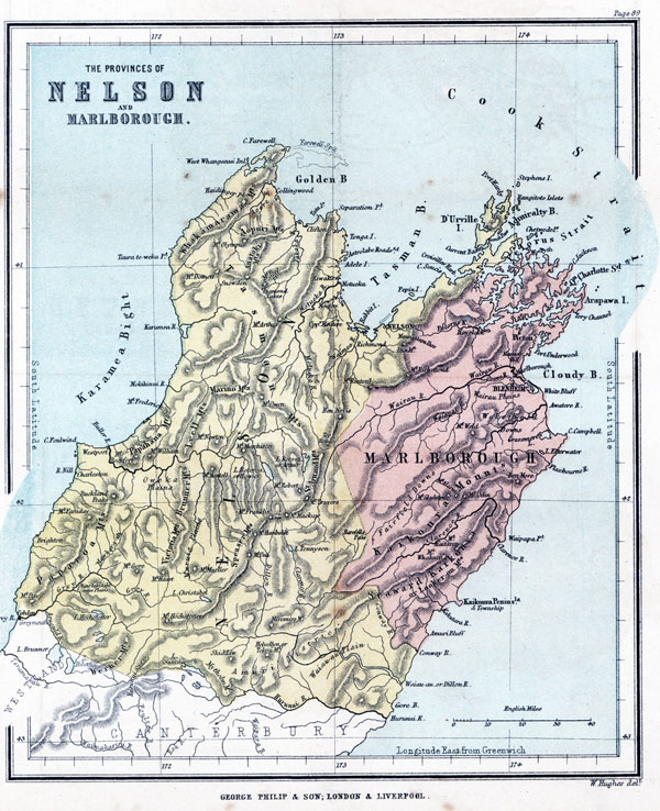
THE PROVINCE OF NELSON.
SYNOPSIS.
TOWNS. Chief,--Nelson, Cobden, Charleston, Brighton, Westport. Secondary,--(including villages and districts), Collingwood, Clifton, Richmond, Motueka, Riwaka, the Waimea villages, and the Amuri district.
BAYS. Tasman Bay (formerly Blind Bay), Golden Bay (formerly Massacre Bay), Karamea Bight, Admiralty Bay, Gore Bay.
HARBOURS. Nelson Haven, Croisilles, Port Hardy, West Whanganui, and the mouths of the Waimea, Karamea, Mohikinui, Buller, Grey, and Waiau-ua rivers.
STRAITS. Current Basin, French Pass, Astrolabe Road.
CAPES. Foulwind, Farewell, Farewell Spit, Separation Point, Cape Soucis, Francis Head, and Taura-te-weka, or Rock Point.
ISLANDS. D'Urville Island, Stephen Island, Pepin Island, Rabbit Island, and Adele Island.
LAKES. Howick or Rotoroa, Arthur or Rotoiti, Hochstetter, Christabel, Tennyson, and Diamond lakes.
[Image of page 90]
MOUNTAINS. Ranges,--Spencer, Tasman, Whakamarama, Anatoki, Marino, Lyell, Papahaua, St Arnaud, Paparoa, Brunner, Victoria, and Mytholin. Peaks,--Haidinger, 3,990 feet; Olympus, 5,400; Domett, 5,400; Snowdon, 5,800; Peel, 6,000; Arthur, 5,800; Owen, Frederick, 3,500; Rochfort, 3,572; William, 3,611; Newton; Mantell, 6,000; Murchison, 4,850; Robert, 6,140; Travers, 7,000; Mackay, 7,500; Franklin, 10,000; Humboldt; Una, 8,000; Mueller; Miromiro, 6,550; Tekoa, 5,370; Skiddaw, 5,740; Hochstetter, Gore, Buckland Peaks, Faraday, Davy, and the Dun Mountain.
RIVERS. Grey, Buller, Aorere, Takaka, Motueka, Waimea, Waimangaroa, Mohikinui, Whanganui, Karamea, Heaphy, Fox, Nill, Waiau-ua, Maruia, Thackeray, Ahaura, Arnould, Hurunui, and Conway.
PLAINS. Waiau-ua, Hanmer, Waimea, Maruia, Ohinetakitaki.
STATISTICS.
Area,--7,000,000 acres.
Population of Province ............... 23,814[?]
Population of chief towns:--
Nelson ....................................... 5,452[?]
Westport ....................................... 1,500[?]
Charleston ...................................... 2,335[?]
Brighton........................................ 1,293[?]
Cobden .......................................... 717[?]
THE PROVINCE OF NELSON.
This province constituted originally one of the New Zealand Company's Cook Strait Settlements, founded in the year 1841. It was proclaimed a province under the New Zealand Constitution Act in 1852, when its boundaries were defined. At that time, however, its boundaries included the present province of Marlborough, which was subsequently constituted a separate province, being proclaimed under an Act of the General Assembly of New Zealand in 1859.
[Image of page 91]
The present province of Nelson, therefore, consists principally of the north-western portion of the South Island, and is separated from the Canterbury province and the newly constituted County of Westland by the River Hurunui to its source, thence by a line to Lake Brunner, and by the rivers Arnould and Grey to the western coast. From the Marlborough province it is separated by an irregular line, commencing near Cape Francis, in Cook Strait, and terminating south of the Amuri Bluff, at the mouth of the River Conway.
The coast line of this province consists of three portions, --first, that on the west, extending from the mouth of the Grey northwards to Farewell Spit; secondly, that formed on the north by the deep indentations of Tasman and Golden Bay, extending from Farewell Spit eastwards to Francis Head; and thirdly, a detached strip on the eastern side, south of the Marlborough province, and lying between the mouths of the Rivers Conway and Hurunui.
Commencing with the first of these portions at its southern extremity, and starting from the mouth of the River Grey, on which is situated the town of Cobden (which can be reached by vessels drawing from 8 to 10 feet of water, and opposite to which is the town of Greymouth, on the southern or Westland side of the river), and directing our course towards the north-east, we pass along the rugged New Zealand Gold Coast, leaving behind us in succession the newly-built but populous towns of Brighton and Charleston, and approach the rocky promontory of Cape Foulwind, so named by Captain Cook.
Having rounded this promontory we soon arrive at the mouth of the River Buller, named after Mr. Charles Buller, President of the Board of Trade, and legal adviser to the New Zealand Company, which is accessible to vessels of light draught, and on which is situated the town of Westport, another thriving offspring of the gold-fields.
[Image of page 92]
From the mouth of the Buller northwards to Cape Farewell, a promontory 630 feet in height, the coast is steep and rugged, and destitute of harbours, with the exception of the small ones at the mouths of the Mohikinui and Karamea rivers, which empty themselves into the Karamea Bight, an extensive bay stretching northwards from Cape Foulwind to Taura-te-weka Point, and West Whanganui Inlet, a little to the south of Cape Farewell. Along this coast, however, there are large deposits of excellent coal, which will hereafter become more extensively worked, and afford a staple article of export to the province.
At Cape Farewell the second or northern division of the coast begins, but we must first round a very long and narrow low sandy spit or bank, called Farewell Spit; and having done this we enter Golden Bay, called by Tasman Massacre Bay, on account of the murder of some of his crew by natives of the island. The bay derives its more pleasing name of Golden from the circumstance that the first New Zealand gold-field was discovered upon its shores. Its coast is in parts rough and mountainous, and in others low and sandy. The rivers Aorere and Takaka empty themselves into this bay, and can be entered by small vessels. The small town of Collingwood is situated at the mouth of the Aorere. This bay is divided from Tasman Bay by the rocky headland called Separation Point.
Tasman Bay was named Blind Bay by Captain Cook, but that name is not now in use. Turning to the south from Separation Point, along the western shore of Tasman Bay, we pass through the Astrolabe Sound, between Adele Island and the mainland, which furnishes a secure roadstead for vessels in almost all weathers. A little farther on is the mouth of the Motueka river, where is the Motueka village, with a considerable expanse of flat open country in its neighbourhood, and the districts of Riwaka and Moutere. Further south is Rabbit Island, opposite to
[Image of page 93]
the mouth of the Waimea River, a well sheltered harbour accessible for small craft. The country bordering this part of the Bay is low and fertile to within a short distance of the shore. The entrance to the Waimea river is near the southernmost recess of the bay; and from thence the coast turns to the north-east, and passes Nelson Haven, a harbour of still water affording perfect security to vessels of a large size. The entrance to the harbour is very narrow,--between the rocky main coast and the extremity of a long bank of boulders, which forms a barrier to the harbour against the sea, and on which a lighthouse has been erected. The City of Nelson stands upon its shore.
Pursuing our course towards the north-east, we pass Pepin Island, and then, rounding Cape Soucis, enter the Croisilles Harbour, near which chrome and copper ores have been discovered and worked; and we then enter the Current Basin, and reach the French Pass or Strait, a narrow but sheltered and deep channel between D'Urville Island and a rocky point of the peninsula which terminates the mainland of the Nelson province at Francis Head, to the north of which lie the Chetwode Islands, which also form a part of the province. The wider channel into which the French Pass leads is called. Admiralty Bay. D'Urville Island, with its satellites Stephen Island and the Rangitoto Islets, are also included within the province. D'Urville Island is rocky and precipitous; it has one excellent harbour at its northern, extremity, Port Hardy, and there is a scanty and scattered population upon its shores. The small eastern portion of coast line belonging to this province lies to the south of the province of Marlborough, and extends only from the mouth of the River Conway to that of the Hurunui. It is generally rocky, but has beaches at intervals, and is divided about midway by the River Waiau-ua or Dillon, between which river and the mouth of the Hurunui is Gore Bay, where there is an anchorage and a shipping place for wool and other produce of the Amuri district.
[Image of page 94]
A large proportion of the Nelson province consists of high and rugged mountain country, interspersed with valleys of considerable extent. "In the province of Nelson," says Dr. Hochstetter, "the Southern Alps send off outliers in the shape of mountain chains 5000 and 6000 feet high, covered in winter with deep snow, as far as Cook Strait."
The principal one of these branches occupies the central part of the province, and affords a watershed for the larger livers both to the east and west coasts of the island. The southern portion of this range is called the Spencer Mountains, and extends from the southern boundary of the province northwards for a distance of 50 miles, when it culminates in Mount Franklin, the highest elevation in the province, named in honour of Sir John Franklin, the celebrated Arctic Explorer, and Governor of Tasmania, who took a lively interest in the early colonisation of New Zealand. It reaches 10,000 feet in height.
From Mount Franklin the main range continues, at an inferior elevation, under the names of the St. Arnaud and Tasman Mountains, towards the north-western extremity of the province. Among many remarkable peaks in the main range both to the north and south of Mount Franklin, Mounts Humboldt and Una to the south, and Mounts Mackay and Travers to the north, are particularly worthy of notice.
On either side of the main range numerous branch chains stretch in a north-east and north-west direction towards the coast, between which flow the principal rivers of the province. The lateral branches stretching towards the north-east will be generally described in the account of the province of Marlborough. The most northerly and chief, however, of these, constituting the principal barrier between that province and the province of Nelson, starts from a little north of Mount Franklin, and terminates in the rocky peninsulas which form the Pelorus Sound. This branch chain, together with the Spencer and
[Image of page 95]
Tasman Mountains, form the main watershed of this portion of the South Island. The peaks Ben Nevis, Mounts Rintoul and Richmond (known locally as the "Devil's Arm Chair," and the "Patriarch"), and the Dun Mountain, form striking features in its scenery, besides being important landmarks in the boundary line between the provinces.
This branch chain and the Tasman Mountains together form the two sides of an almost equilateral triangle, the base of which is occupied by the sea, being broken into by Tasman and Golden Bays; whilst a large part of the agricultural land of the province is contained within the narrower portion of this figure where the sea has ceased to encroach. The Motueka and Waimea rivers have their sources in the apex of this triangle, and flow into Tasman Bay. They both afford shelter for small vessels, and the villages of Motueka and Richmond are situated at their mouths, with some extent of fertile alluvial land around them.
Further towards the north-west, the two rivers Takaka and Aorere, rising in the Tasman Mountains, empty themselves into Golden Bay. Near the source of the former are the small but picturesque Diamond Lakes. The town of Collingwood is situated at the mouth of Aorere, and the village of Clifton not far from that of the Takaka. There is a small extent of good level land in the valleys of these rivers and on the coast between them, but they are principally supported by the gold diggings, which are scattered over the entire district to the north of the Motueka river. Coal and limestone also exist in considerable quantities, whilst plumbago and other minerals are also found.
From the opposite range on the east of the triangle no important rivers flow through this province, nor has any gold been discovered on its north-western slopes; but copper ore has been worked, though not very successfully, both on the Dun Mountain and near the Croisilles
[Image of page 96]
Harbour, and chrome ore in the form of chromic iron is very abundant in both localities. At the Dun Mountains considerable works have been erected for the extraction of these ores, and a tramroad laid down from the neighbourhood of the copper lodes to the extremity of the commodious wharf in Nelson Haven, which passes through Nelson City, affording convenient means of transit for goods and passengers to the citizens.
There is a marked difference between the geological construction of these two ranges, the Tasman Mountains consisting of primary crystalline rocks, granite, and gneiss, whilst the eastern range is formed chiefly of sedimentary sandstones and chalk, corresponding with the composition of the ranges in the interior and eastern part of the North Island.
It will be observed that the angle already described as formed by these diverging chains, impresses a corresponding form upon the basins of the two bays, Golden and Tasman Bay. It is at the lower angle of Tasman Bay that Nelson Haven is formed, being enclosed to seaward, with the exception of an aperture of only 100 feet wide, by a remarkable boulder-bank, which forms the continuation of a rocky cliff, extending from Pepin Island in a south-westerly direction.
The lateral branches from the Spencer Mountains towards the west are broken up into numerous subordinate chains, intersected by several streams, and particularly by the larger rivers, the Grey and Buller, and their tributaries. To the north are the Whakamarama, Aopuri, and Anatoki Mountains, forming a northern and northwestern supplement to the Tasman range, Mount Olympus (5,400 feet) occupying a central position. To the north of the Buller River, and forming the outline of the valley of that river and its northern tributaries, are the Marino, Lyell, and Papahaua ranges, with their principal peaks, Mounts Owen, Newton, Frederick, William, and Rochfort, averaging from 3,000 to 4,000 feet in height. The
[Image of page 97]
rivers Karamea and Mohikinui rise to the north of the Marino Mountains, and flow into the Karamea Bight. They are accessible to small vessels; and from the point where their sources almost unite a pass and track are found across the Tasman Mountains into the valley of the Motueka.
The Buller River is formed by the confluence of two streams flowing through the Lakes Howick and Arthur, in the neighbourhood of which is much romantic and magnificent scenery. It receives from the south two tributary streams of considerable magnitude, the Maruia and the Thackeray, the valleys of which rivers are divided by the Victoria and Brunner Mountains; whilst between the Thackeray, the Grey, and the west-coast, is an extensive isolated chain, the Paparoa. In the valleys of these rivers are extensive plains called the Maruia and Oweka plains. Near the source of the Maruia, on its right bank, is Mount Mueller, and near its junction with the Buller, Mount Mantell (6,000 feet); whilst in the Spenser Mountains, to the east of the valley, in addition to Mount Franklin, are other lofty peaks, such as Mounts Humboldt and Una, averaging 8,000 feet. The principal peaks in the Paparua chain are Mount Davy, Mount Faraday, and the Buckland Peaks.
The remaining portions of the province consist of two districts, one drained by the Grey and its tributaries into the Westland Bight, and the other by the Clarence, Waiau-ua, and Hurunui, into the ocean on the eastern coast.
The source of the Grey is in Lake Christabel, a small but beautiful lake at the foot of the Spenser Mountains. This river receives as tributaries the Mawhera-iti from the north, and the Ahaura and Arnould from the south, the latter flowing from Lake Brunner. To the south of the Ahaura are the Werner Mountains, on either side of which are a lake and mountain named in honour of Dr. Hochstetter, the Austrian savant, who visited New Zealand in
[Image of page 98]
1859; and between the Ahaura and the main stream are the Ohine-taki-taki plains. In the angle formed by the Mawhera with the Grey are Mount Haast and Mount Gore (4,500 feet). The entire region watered by the rivers Buller and Grey, as well as the coast country between them, contains deposits of gold. The gold coast of the province may indeed be described as extending from the Grey river to the Mohikinui river, a distance of seventy miles. It contains a population of upwards of 10,000, and several large towns,--the most important being Cobden, at the mouth of the Buller; Westport, at the mouth of the Grey; Brighton, with its suburb St. Kilda, on the small river called Fox; and Charleston on the Nill.
The south-eastern portion of the province is called the Amuri district. The Waiau-ua or Dillon River, a large and broad stream of water, flows through its centre, having its source in Mount Franklin. Its course is at first southerly for about 30 miles, when, making a circuit round Mount Miromiro, a mountain 6,550 feet in height, it turns at right angles to the east, passing through a considerable extent of level country known as the Waiau and Hanmer plains, affording excellent pasture, with some good agricultural land. The mouth of the river is accessible to small vessels.
The River Clarence also rises on Mount Franklin, and flows at first parallel with the Waiau-ua, passing in its course through Lake Tennyson; but it also shortly turns abruptly to the east, and enters the Province of Marlborough.
To the south of the rectangular bend of the Waiau-ua River is the peak called Skiddaw, and another called Tekoa or Helvellyn, both approaching 6,000 feet in height. The Hurunui River forms the southern boundary of the province. It rises on a saddle which affords a pass into the valley of the Grey, flows through Lake Sumner, skirts the Mytholm Mountains on its left bank, and then, pursuing a direct easterly course, empties itself upon the east
[Image of page 99]
coast into the Pacific Ocean, a little to the north of Pegasus Bay.
From the description which has been given of the physical characteristics of this province, it will have been seen that it contains a large proportion of rugged mountainous country, the lower slopes and valleys of which afford good sheep pasture. The lowlands are of very limited extent, being confined almost to the shores of the two principal bays, and to a narrow strip along some portions of the west coast. The wealth of the province consists in its mineral resources, though these, with the exception of its valuable gold-fields, and its known deposits of coal and chrome ore, are at present very imperfectly explored. The mildness of its climate, ensured by the sheltered position of Tasman Bay, will secure to the city of Nelson and its precincts a reputation, already widely spread, of being a desirable home for those who seek in the colony facilities for comfort and enjoyment, rather than a field for enterprise and speculation.
The city of Nelson is built upon a favoured spot, open towards the north, and sheltered by high mountains from the cold southerly winds, and of that undulating character which affords scope to architectural taste, of which advantage has been taken. Nelson College is a fine and extensive building, and the English occupies a site of almost unrivalled elegance in the centre of the city. Cobden, Brighton, Charleston, and Westport are large and thriving towns, of the usual character of gold-field towns. The other principal towns and villages are the Waimea and other villages, which form suburbs to the city of Nelson; the principal being Richmond, Motueka, Riwaka, and Moutere, on rivers of similar names, with Collingwood and Clifton on Golden Bay.
The area of the province is about 7,100,000 acres, and its population 23,814. The population of the City of Nelson, 5,652; Westport, 1,500; Charleston, 2,235: Brighton, 1,293; Cobden, 727.
[Image of page 100]
SECTION VI.
THE PROVINCE OF MARLBOROUGH.
SYNOPSIS.
TOWNS. Chief,--Blenheim. Secondary,-- Picton, Havelock, Marlborough, Renwick, Kaikoura.
BAYS. Cloudy Bay, Pelorus Sound, Queen Charlotte Sound, Tory Channel.
HARBOURS. Pelorus, Picton, Port Gore, Port Underwood, Mouth of Wairau, Kaikoura.
CAPES. Francis Head, Cape Jackson, Cape Koamoroo, Wellington Head, White Bluff, Cape Campbell, Waipapa Point, Kaikoura Peninsula, Amuri Bluff.
ISLANDS. Orient, Forsyth, Chetwode, Arapawa.
LAKES. Grassmere, Elterwater.
MOUNTAINS. Ranges,--Inland Kaikoura; Seaward Kaikoura, or Looker-on Mountains. Peaks,--Tapuaenuka, or Mount Odin, 9,700 feet; Mount Richmond; Rintoul; Weld, 5,600 feet; Gog; Magog; Kaitarau, 8,700 feet; Whakari, 8,500 feet.
PLAINS. Wairau Plain, Fairfield and Wakefield Downs, Kaikoura Plain.
RIVERS.--Pelorus, Wairau, Awatere, Clarence, Conway.
STATISTICS.
Area,--2,500,000 acres.
Population of Province ..............4,371[?]
" Blenheim ..............500
" Picton ..............465
THE PROVINCE OF MARLBOROUGH.
This portion of the South Island was at first included within the boundaries assigned to the Nelson province in the year 1853. It was however constituted a separate province by proclamation, under an Act of the General
[Image of page 101]
Assembly of New Zealand in the year 1859, as the Province of Marlborough.
It occupies the north-eastern portion of the South Island, and is separated from the Nelson province towards the west and south by an irregular line commencing in Cook Strait near Francis Head,--the northern extremity of the tongue of land which bounds Tasman Bay on its eastern side, and including within the Marlborough province the whole of the Pelorus valley, and the principal portions of those of the Wairau, Awatere, and Clarence; and finally following up the course of the river Conway to the coast south of the Amuri Bluff. Some of the prominent points in this line are the Dun Mountain, Mounts Richmond and Rintoul, the Top-house, and the south-western extremity of the Kaikoura Mountains. On the north and north-east it is bounded by Cook Strait, and on the south-east by the ocean.
The coast-line of the northern part of the province, between Tasman Bay and Cloudy Bay, is broken into by two long inlets from Cook Strait, separated by a straggling rocky peninsula, of which the northern extremity is Cape Jackson, and sub-divided into innumerable coves, generally of deep water, and surrounded by steep and lofty hills. The most westerly of these inlets is the Pelorus Sound, which has at its entrance the Chetwode and Forsyth Islands, and at its southern extremity the town of Havelock. The other inlet is Queen Charlotte Sound, named by Captain Cook, who made its secure and ample harbourage the rendezvous and headquarters of several of his expeditions. This sound is entered by two channels, one on either side of the Arapawa Island, of which the southernmost is named Tory Channel, after the pioneer vessel of the New Zealand Company sent out in 1839 to explore the shores of Cook Strait, and which was the first ship that ventured through the channel. At the head of this sound, on its southern shore, is situated the town of Picton, the principal port of the province, and its capital
[Image of page 102]
town until the removal of the local government to Blenheim, in the year 1865.
After passing through Tory Channel, and following the coast southwards for a few miles, Ave find it again indented by the extensive and secure harbour of Port Underwood, at the northern extremity of Cloudy Bay. From this harbour vessels have sailed annually for several years, carrying to England the wool produced in the Nelson and Marlborough provinces. A little further south than Port Underwood is a small bay called Whites Bay, at which the western end of the Cook Strait telegraph joins the shore, its other extremity being at Lyall Bay, in the Wellington province. Here a telegraphic station is situated for receiving telegrams by means of the cable, and transmitting them to the various stations throughout the island, as well as for forwarding others to the opposite side of the strait. At this point the mass of mountains through which the two main inlets and their numerous channels ramify, has its termination, and the flat shore of Cloudy Bay commences, which continues to its southern extremity at the White Bluff, a prominent feature on the coast, 890 feet in height.
To the north of the White Bluff is the estuary of the Wairau River, a wide sandy bank with several deep channels, some of which are navigable, and upon which the chief town--Blenheim--is built. A short distance below the Bluff the River Awatere discharges itself; and the shore continues flat until we reach the promontory of Cape Campbell,--a little to the north of which, and close to the coast, is Lake Grassmere, a small lake, but the largest in the province; and a little to the south of it is Lake Elterwater.
At Cape Campbell the coast again assumes a mountainous character, and is flanked by the lofty Kaikoura ranges. Between the landward and seaward Kaikoura ranges flows the River Clarence, which empties itself a little to the south of Waipapa Point. The coast
[Image of page 103]
continues rough and broken to its southern extremity at the mouth of the Conway River. About half-way between the mouth of the Clarence and that of the Conway is a singular projecting promontory, called the Kaikoura Peninsula, which affords some shelter to vessels, and on which a small town of the same name is situated. The eastern extremity of the peninsula is called East Head, and forms the northern headland of a bay, of which the southern headland is called the Amuri Bluff, a few miles only north of the Conway River.
The interior of this province is very mountainous, its northern part being bounded on the west by the eastern fork of the main range already described, spurs from which ramify towards the coast, and form the valleys of the Pelorus and Wairau Rivers. The Dun Mountain, Mount Richmond, and Mount Rintoul, mark salient angles in the boundary line; the two latter being more commonly known in the province as the Patriarch and the Devil's Arm Chair. Mount Rintoul is 4,720 feet in height. The central portion also of the province contains lateral branches from the main range, which divide and confine the parallel valleys of the Wairau and Awatere Rivers. These chains are of considerable height,--Mount Weld, one of their peaks, reaching to 5,600 feet; but the loftiest mountains in the province are in the south, and consist of two parallel ranges, which are disconnected with the main range, but have a similar direction with its lateral branch chains. These are the inland and seaward Kaikoura ranges,--the latter being also known as the Looker-on Mountains, which designation was bestowed by Captain Cook. Between these ranges flows the River Clarence, and on their summits are the lofty peaks of Tapuaenuka, or Mount Odin, 9,700 feet; Mount Alarm, 9,300 feet; and Mounts Gladstone, Kaitarau, and Whakari, all of great elevation,--with numerous others, several of them being extinct volcanic cones.
The rivers of the province, owing to the parallelism
[Image of page 104]
of the principal ranges, are of considerable size and length. The Pelorus, however, is an exception, rising near the Dun Mountain, and flowing through a narrow but fertile valley into the head of the sound of the same name. Near its source is the Maungatapu Pass into the Nelson province; and between its mouth and that of a smaller stream, the Kaituna, is situated the town of Havelock, the port for a small district where gold was at first obtained in very considerable quantities; but the gold-field, being very small, is now almost exhausted. By the valley of the Kaituna stream is a pass to Blenheim, the chief town.
The Wairau River rises in the Nelson province on the slopes of Mount Franklin, near Lake Tennyson, and enters the Marlborough province at the pass called the Top-house. It flows towards the north-east, and receives as a tributary on its right bank the Waiopai. It empties itself into Cloudy Bay; and about nine miles from its mouth, upon a delta stream,--the Opawa,--is situated the town of Blenheim, the capital town of the province, and seat of the local government since its removal from Picton in 1865; and which is connected with Picton, still the principal port of the province, by a good road, traversed daily by public conveyances. The Opawa branch is accessible to small vessels, and the Wairau River itself is navigable for about five miles, as far as the town of Marlborough. The Wairau valley contains a considerable extent of level agricultural land in its lower part, known as the Wairau Plain. The upper part of the valley and the hills on its southern side are well grassed, and afford good sheep pasture.
The Awatere rises near the boundary of the province at Barefell's Pass, flows across the Fairfield Downs in the upper part of its course, and the Wakefield Downs towards its mouth, and enters Cloudy Bay to the south of the White Bluff. The Clarence rises in the Nelson province, on the slopes of Mount Franklin, flows through Lake
[Inserted unpaginated illustration]
[Image of page 105]
Tennyson, and receives on its left bank its tributary the Acheron, which forms part of the boundary of the province. At the junction of the Acheron the Clarence enters the Marlborough province, and flows for a considerable part of its course in a north-easterly direction, in a narrow valley between the two lofty ranges of the Kaikoura Mountains; after which it changes its course to the southeast, and empties itself into the ocean to the south of Waipapa Point. The only other streams in this province of any size are--the Conway, its southern boundary; the Kahutara, south of the Kaikoura Peninsula; and the Flaxbourne, south of Cape Campbell.
The interior of this province consists, as has been described, principally of mountainous country. The Wairau Plain, the Wakefield Downs, near the mouth of the Awatere River, and the Kaikoura Plain, between the mountains and the sea, are adapted for agriculture; but the remainder of the country south of the Wairau River is only fit for, and is almost exclusively occupied as, sheep and cattle stations. North of the Wairau River the greater portion of the valleys and flat land are heavily timbered; and in the more accessible parts adjoining the sounds, several saw-mills, mostly worked by steam power, employ a considerable population.
The area of the province is about 2,500,000 acres, and its population, 4,371. The population of its chief town, Blenheim, is 500, and that of Picton, 465.
SECTION VII.
THE PROVINCE OF CANTERBURY.
SYNOPSIS.
TOWNS. Chief,--Christchurch, Lyttelton, Timaru, Kaiapoi. Secondary (including villages),--Rangiora, Oxford, Akaroa, Waimatemate, Temuka, Leithfield, Prebbleton, Arowhenua, Geraldine, Leeston.
[Image of page 106]
BAYS. Canterbury Bight, Pegasus Bay.
HARBOURS. Port Lyttelton, Port Levy, Pigeon Bay, Akaroa Harbour.
CAPES. Godley Head, East Head, Dyke Head, and other headlands of Banks Peninsula.
ISLANDS. Motunau, or Table Island.
LAKES. Sumner, Coleridge, Ellesmere, Tekapo, Pukaki, Ohau, Heron, Tripp, Howard, Acland.
MOUNTAINS. Ranges,--Southern Alps, Black range, Rolleston range, Ragged range, Two Thumbs range, Moorhouse range, Ritter range, Bealey range, Puketiraki Hills, Mount Somers, Harper Hills, Ben Ohau and Ben More ranges, and the Hunters Hills, with Banks Peninsula. Peaks,--Mounts Cook, Tyndall, Sinclair, Arrowsmith, Haidinger, Sefton, De la Beche, Darwin, Aspiring, Avalanche, Tasman, Petermann, Elie de Beaumont, Peel, Grey, Nimrod, Armstrong, Rolleston, Torlesse, Park, Ida, and Peveril and Scarcliff peaks.
RIVERS. Hurunui, Ashley, Waimakariri, Rakaia, Selwyn, Ashburton, Rangitata, Waipara, Orari, Opihi, Avon, Heathcote, and Waitaki.
PLAINS. Canterbury Plains, Waipara Plains, Mackenzie Plains, Mount Grey Downs, Timaru Downs.
STATISTICS.
Area,--8,693,000 acres.
Population of Province .................... 38,300[?]
Population of Chief Towns:--
City of Christchurch ........................ 6,647
Lyttelton ....................................... 2,546[?]
Timaru....................................... 1,027
Rangiora..................................... 1,042
Kaiapoi.....................................868[?]
THE PROVINCE OF CANTERBURY.
The settlement of Canterbury originated with the Canterbury Association in the year 1848, but was proclaimed a province in the year 1852, when its boundaries
[Image of page 107]
were defined as extending from the east to the west coast, and from the Province of Nelson on the north to that of Otago on the south. In the year 1867, however, the General Assembly of New Zealand passed an act, separating the country lying to the east of the Southern Alps from the country lying to the west. The former only is now called the Province of Canterbury, the latter being called the County of Westland.
This province occupies the eastern portion of the centre of the South Island. It is bounded on the east by the sea; on the north by the River Hurunui, which separates it from the Province of Nelson; on the west by the summit of the high range of mountains, or the watershed between the east or west coasts, extending from the saddle separating the sources of the Hurunui and Teremakau on the north to Mount Aspiring on the south, which separates it from Westland. On the south it is bounded by the Rivers Waitaki and Ohau; and a straight line, drawn from the outlet of Lake Ohau to Mount Aspiring, separating it from Otago.
The coast-line of this province is confined to the eastern shore of the island, and is divided into two unequal portions by the mountainous district of Banks Peninsula. That portion which extends northwards round Pegasus Bay is called the Forty-mile Beach; whilst a similar flat shingly coast-line, also bordering the plains on the south, and extending from Little River nearly to Timaru, is called the Ninety-mile Beach.
Starting from the mouth of the River Hurunui, at the north-east extremity of the province, and travelling southward along the coast, we enter Pegasus Bay. This bay is forty miles in breadth, and is protected on the north by the projecting, low, limestone ranges near the mouth of the Hurunui (off which lies Motunau or Table Island), and by Banks Peninsula. The low lands lying between these two regions form the northern portion of the Canterbury Plains, and are watered by numerous minor streams,
[Image of page 108]
and the larger rivers, Waimakariri and Ashley,--on the former of which is situated the town of Kaiapoi.
Arriving at Banks Peninsula we find it to be a rocky, volcanic projection, about thirty miles long and eighteen wide, standing out from the Canterbury Plains, and totally unconnected with any other range of hills. In sailing round this barrier we soon discover the extensive harbour of Port Lyttelton (or Cooper), on the northern shore of which is situated the town and port of Lyttelton, which is connected by a railway about seven miles long with Christchurch, the capital of the province, situated on the plains inland. The northern headland of the harbour is called Godley Head, on which a lighthouse was constructed in 1865.
Leaving Port Lyttelton, and continuing our course round Banks Peninsula, we pass in succession Port Levy and Pigeon Bay, with numerous smaller bays, and arrive at the deep and sheltered inlet of Akaroa Harbour, running in a northerly direction into the heart of the peninsula, on the eastern shore of which is situated the town of Akaroa.
In our progress south, leaving Banks Peninsula behind us, and entering the Canterbury Bight, we pass Lake Ellesmere, a large sheet of fresh water, separated from the sea only by a narrow strip of beach and loose shingle; and we then find that the plains which we lost sight of when leaving Pegasus Bay appear again, forming one continuous flat,--unbroken, except by rivers; as the rocky peninsula round which we have been sailing is entirely isolated. Along these plains, which extend inland for about thirty miles, we continue in a southward course for more than seventy miles on an uninterrupted level; passing in our progress the mouths of the rivers Rakaia, Ashburton, and Rangitata, and several lesser streams, such as the Selwyn,--which empties itself into Lake Ellesmere,--the Orari, and Opihi, and arrive at Timaru, a town situated close to the sea, on the low downs which
[Image of page 109]
form the southern boundary of the Canterbury Plains. For a short distance south of Timaru these downs are still found abutting on the sea shore; but afterwards they recede further inland, leaving a narrow strip of level country at their base, extending as far as the River Waitaki,--the southern boundary of the province.
This province may be divided, with regard to its physical features, into three distinct parts:--First, the lofty ranges of the Southern Alps, which attain their greatest altitude (13,200 feet) in Mount Cook; the hills bordering the Hurunui river on the north, and the downs on which the town of Timaru is situated on the south, being merely lower elevations of the same mountain system. Secondly, the alluvial fiat of the Canterbury plains, formed from the soil deposited by the rivers flowing out of the mountains. And, thirdly, the volcanic mass of hills on the coast called Banks Peninsula, standing apart on the edge of the plains.
The summits of the Southern Alps are in many instances covered with perpetual snow; and numerous large glaciers exist, which form the sources of the principal rivers in the province. Lakes also are found among them of considerable extent and depth, the principal of which are Ohau, Pukaki, Tekapo, Coleridge, and Sumner.
In addition to the main range of the Southern Alps, there are numerous subordinate chains ramifying from it, between which the chief rivers of the province flow; such are the Black range, Rolleston range, Ragged range, Two Thumbs range, Moorhouse range, Ritter range, and Bealey range, all of which are connected with the central chain; whilst the Puketiraki, Palmer, and Mount Somers in the north, the Harper ranges near the centre of the province, and the Ben Ohau and Ben More Mountains, and the Hunters Hills, occupying the south-eastern portion of the province,--are more or less detached. Banks Peninsula, the mountainous district on the coast, consists of a crest of isolated hills, with ramifications extending to the
[Image of page 110]
shore in all directions, forming a bluff rocky coast round the peninsula. Its highest elevation, Mount Herbert, is 3,050 feet. The peninsula is about thirty miles long and twenty in breadth. It consists almost entirely of steep rugged hills, covered partly with timber, and partly with fern and grass.
The principal rivers of the province partake in general of the nature of large mountain torrents,--becoming very deep and rapid when the snow melts on the hills, or when a large quantity of rain has fallen, but usually traversing the plains in broad shallow streams over beds of shingle, and are consequently unnavigable. The small rivers, the Heathcote and the Avon, however, on the latter of which is situated the city of Christchurch, are of a different character, and are navigable by small vessels for some distance. Vessels of considerable size also discharge their cargoes at the town of Kaiapoi, about three miles distant from the mouth of the Waimakariri.
Of the principal rivers, the course of the Hurunui has already been described among the rivers of the Nelson province. It passes through Lake Sumner, a considerable lake, at an elevation of 1,697 feet above the sea level. The course of the Ashley is of inferior length to that of the other principal rivers. It rises in the Puketiraki Mountains, and between it and the Hurunui lie the Mount Grey and Waipara Downs; and behind the former, Mount Grey Peak, 3,000 feet high. The Waimakariri rises in the central chain, and has numerous tributaries, the principal of which are the Bealy, Hawdon, Poulter, and Esk. The coach-road to the west coast runs along the valley of this river, and crosses the Alps by Arthur's Pass, at the source of the Bealy. The Waimakariri pursues a devious and irregular course, skirting the Black range and the Puketiraki range, and, passing Harewood Forest, flows through the open grassy plains into Pegasus Bay. The town of Kaiapoi is situated about two miles from its mouth.
[Image of page 111]
The Rakaia river rises in two main branches, divided by the Rolleston range, both fed by glaciers; and, after their junction near Mount Algidus, flows for some distance between Palmer range and Lake Coleridge, from which it is divided only by a narrow neck of land: after passing between Mount Hutt on the right bank, and the Malvern Hills on the left, it emerges into the Canterbury Plains, about thirty-five miles from its mouth, and pursues a rapid course to the ocean, emptying itself into the Canterbury Bight. The principal tributaries of the Rakaia are the Wilberforce, Mathias, Harper, Avoca, and Acheron. At the head of the Wilberforce is Browning's Pass, 4,752 feet above the sea.
To the north of the Rakaia, a small stream, the Selwyn, rises in the Malvern Hills, and flows into Lake Ellesmere; and near the base of Banks Peninsula are the two small streams, Heathcote and Avon, on the latter of which stands Christchurch, the capital of the province. This city is connected by a railway about seven miles long (and passing through a tunnel nearly two miles in length) with Port Lyttelton, situated at the north-western extremity of Banks Peninsula.
The Ashburton rises near Mount Arrowsmith,--passes between the Clent Hills, and the lakes Tripp, Howard, and Acland, and to the south of Mount Somers, 5,240 feet in height, and Alford Forest,--and then flows through the plains to the sea, having the small town of Ashburton on its left bank, about eight miles from the coast.
The Rangitata is formed by the junction of the Clyde and the Havelock, which have their sources near Mount Tyndall, among the enormous snow-fields and glaciers of that Alpine region. These rivers unite east of Cloudy Peak, and passing the Two Thumbs range, with its lofty peak Mount Sinclair, and Mount Potts on its opposite bank, and then between Harper range and Mount Peel, it flows through the southern portion of the plains to the Ninety-mile Beach.
[Image of page 112]
The southern portion of the province also contains a number of smaller rivers having their sources in the Two Thumbs range, such as the Orari, Opihi, Pareora, Otaio, and Waiho. Between the Opihi and the Pareora are the Timaru Downs; and on an open roadstead is situated the town of Timaru, the second largest in the province; whilst on the Opihi, and its tributary the Waihi, are the villages of Arowhenua and Geraldine.
The large river, the Waitaki, forms the southern boundary of the province, and has its sources in several large branches rising in the highest portion of the Alps. The central branch, called the Tasman River, is formed by the great glaciers round Mount Cook; and, after a course of about twenty miles, flows through the extensive Lake Pukaki, which name it takes until it joins the right branch, called the Tekapo. This river flows also from a large lake of the same name, which is fed by two considerable rivers, called the Godley and Macaulay Rivers, rising in the Godley and other glaciers. Between these branches and the River Ohau are the Mackenzie Plains. The left branch, called the Ohau, flowing through the Ohau Lake, divides also into two streams in its upper course, called the Hopkins and Dobson Rivers, separated by the Naumann range,--and is itself separated from the central branch by the Ben Ohau range throughout its entire length. Lower down, the Waitaki receives as a tributary upon its right bank the River Ahuriri, and also upon its left bank the Hakateramea, which latter rises in the Hunter Hills; and thence a course of thirty-five miles brings it to the ocean, at the southern extremity of the Canterbury Bight.
With the exception of Banks Peninsula and some portions of the mountain ranges, the province is generally very devoid of timber; the Harewood and Alford forests being the largest to which the inhabitants of the plains have easy access. The more hilly districts of the province are used for sheep pasturage; but agricultural
[Image of page 113]
pursuits are extensively carried on upon the Canterbury Plains, and the downs and flat country around and to the south of Timaru, there being upwards of 150,000 acres under cultivation. In addition to the towns which have already been described, there are several of smaller size scattered over the agricultural districts; of which the principal are Rangiora, Leithfield, and Oxford, to the north of Christchurch; and Prebbleton, Temuka, and Waimatemate, to the south.
A railway, the first in New Zealand, was constructed in 1863 from Christchurch to the Heathcote Wharf, a distance of about four miles; and subsequently extended to Lyttelton by means of the Moorhouse tunnel, 2,838 yards in length,--a work of great expense and difficulty, passing as it does through the hard volcanic rocks of that portion of Banks Peninsula. The entire line was completed and opened in 1867; and about the same time the Great Southern line was opened to the public, from Christchurch as far as the river Selwyn, about 22 miles.
The first telegraph line also established in New Zealand united Christchurch and Lyttelton. It was opened July 1, 1862, and has since been continued north and south throughout the island,--through Otago to the Bluff at the extreme south, and to Nelson and Picton in the north; and thence by the electric cable, successfully laid across Cook Strait, August 26, 1866, communication has been opened with Wellington, the capital of New Zealand, and with the northern provinces. The telegraph also crosses the island, following the west coast road from Christchurch to Hokitika, and thence to Greymouth, a distance of 199 miles.
Owing to the flat character of the country, the roads in the eastern portion were easily constructed. The west coast road, however, across the island, was a work of great magnitude, traversing a most rugged and inhospitable region, and was constructed by the local government under extraordinary difficulties,--engineering and other-
[Image of page 114]
wise. It was begun soon after the opening of the gold-fields on the west coast in May, 1865, at which time Westland still formed part of the Canterbury province, though quite inaccessible at that time by land from the eastern side of the province. This substantial but very costly road was completed in May, 1866, and is now traversed by vehicles of every description; a public coach completing the distance of 150 miles between Christchurch and Hokitika in 36 hours, including a night's detention half-way, at the river Cass. Arthur's Pass, by which the above road crosses the Southern Alps, is 3,038 feet above the sea.
There are other passes with bridle-tracks connecting the western with the eastern coasts. Of these the most important is Harper's Pass, across the Hurunui Saddle, 3,008 feet in height. This road, though not well kept in repair, is still much used by stock drivers.
Browning's Pass, at the head of the Wilberforce, one of the tributaries of the Rakaia, is little used, though a bridle-track has been found connecting it with Hokitika; as, owing to its elevation of 4,645 feet above the sea, it becomes snowed up for a considerable portion of the year, and the ascent on the south side is very steep. Whitcombe's Pass, also, about 20 miles south-west of Browning's Pass is of a similar character, its elevation being 4,212 feet above the sea. It unites the headwaters of the Rakaia proper with the source of the Hokitika River.
Haast Pass, in the extreme south of the province, discovered by Dr. Haast in 1863, is a remarkable break in the high chain of mountains, being only 1,716 feet above the sea-level; but it is seldom or never used, no road or track having been formed connecting it with the west coast, as from its position it would benefit the province very little at present.
The area of the province is about 8,693,000 acres. Its population in 1867 amounted to 38,300, and that of its
[Image of page 115]
chief town--the City of Christchurch--to 6,647; that of Port Lyttelton to 2,510; that of Timaru to 1,027; and that of Kaiapoi to 700.
SECTION VIII.
THE COUNTY OF WESTLAND.
SYNOPSIS.
TOWNS. Chief,--Hokitika, Greymouth. Secondary,-- Stafford Town, Ross, Kanieri, Okarita, and Weld.
BAYS. Westland Bight, Bruce Bay, Jackson Bay, Barn Bay, and Awarua or Big Bay.
HARBOURS. Greymouth, Hokitika.
CAPES. Cliffy Head, Abut Head, Oturokua Point, Tititira Head, Arnott Point, Jackson Head, Cascade Point, Awarua Point.
LAKES. Brunner, Poherua, Kanieri, Mahinapua, Okarito, Kakapo, Rotokino, Mapouriki.
MOUNTAINS. Ranges,--Southern Alps (the eastern boundary of the county), Thompson range, Okura range. Peaks,--Kaimatau, Aspiring, Glacier Dome, Castor and Pollux, Alba, Dana, Napoleon, Sefton, Harman, Rolleston, Franklyn.
RIVERS. Grey, Arnould, Teremakau, Arahura, Hokitika, Totara, Mikonui, Waitaka, Whanganui, Poerua, Wataroa, Waiau, Waikukupa, Weheka, Karangarua, Mahitahi, Paringa, Waita, Haast, Arawata, Awarua.
PLAINS. Grey Plain, Sherrin Plain, Okarita and Open Bay Plains.
STATISTICS.
Area,--2,880,000 acres.
Population of County ........... 15,351[?]
Population of Chief Towns:--
Hokitika............................... 4,866
Greymouth............................... 1,607
[Image of page 116]
THE COUNTY OF WESTLAND.
The portion of the South Island which forms the present county of Westland was, until the year 1867, included within the boundaries of the Canterbury province, of which it formed the western portion. Owing, however, to the formidable barrier of the Southern Alps, which cut it off from overland communication with the Canterbury plains and those districts of the eastern portion of that province which had been first settled, and owing also to the extensive circumnavigation of the island which was necessary in order to reach it by sea, it remained an almost terra incognita until the discovery of its rich gold-fields in the year 1865, by explorers who straggled down the coast from Nelson after gold had been discovered to exist in that part of the island.
In the course of the three succeeding years this district became one of the most populous districts of the colony, possessing several large and thriving commercial towns; and in the year 1867 it was separated from the province of Canterbury by Act of the General Assembly, and constituted the County of Westland, with a local government of its own.
It is separated from the present province of Canterbury on the east by the line of watershed of the Southern Alps, running north and south from the saddle between the sources of the Hurunui and Teremakau Rivers to Mount Aspiring; from the province of Nelson on the north by a line running from the saddle before mentioned to Lake Brunner, thence following the Arnould River to its junction with the River Grey, and along the River Grey to its mouth; and from the province of Otago on the south by a line starting from Mount Aspiring, and terminating at the mouth of the River Awarua, in the Big Bay.
The coast-line of the county extends from the mouth of the River Grey southwards to that of the Awarua. It
[Image of page 117]
is generally steep and rugged, densely covered with forest, and bordered at some little distance by the stupendous central mountain-chain, the Southern Alps, the spurs from which form in places precipitous or overhanging cliffs of great height, and very inaccessible.
Starting from the mouth of the River Grey, on which is situated the port and town of Greymouth, the commercial entrepot for the numerous diggings situated upon the banks or neighbourhood of the river, a south-westerly course of about seven miles along a sandy beach brings us to the mouth of the Teremakau River, on which a village is located, the gold-diggings of this district lying upon the Greenstone Creek, which is a branch of the Teremakau. Passing this, we continue our course along a good sandy beach, backed by level terrace country, and here the little River Waimea empties itself, upon which are situated Stafford Town and the Waimea diggings, the most extensive in Westland.
We next reach the river and town of Hokitika, the town being the largest in the county, and the seat of local government. The Hokitika River is a poor harbour, and subject to sudden changes in direction, and in the depth of its water. Large vessels, therefore, remain in the roadstead, and discharge into steamboats which can enter the river with comparative ease. A short distance south of Hokitika, we pass the Lake Mahinapua, fed by a small stream which empties itself into the Hokitika River near its mouth; and continuing our course to the southward, we now pass along a rocky coast broken by the Totara, Mikonui, Waitaka, Whanganui, and Poerua Rivers, to Wataroa River at Abut Head, a distance of about sixty miles from Greymouth.
Here the level country on the coast narrows, and the mountain ranges continue to approach the shore until their spurs form rough, and often inaccessible cliffs, which present to the traveller a number of bold and picturesque points and headlands.
[Image of page 118]
The coast continues with but little variation in character to Arnott Point, a distance of about sixty-five miles, in a direct line from Abut Head, passing the mouths of the Rivers Waiau, Waikukupa, Weheka, Mahitahi (in Bruce Bay), and Paringa (at Tititira Head). From Arnott Point to Arawata River in Jackson Bay, the coast is low and sandy, with extensive plains, covered mostly with dense forest. The River Haast, a large stream, flows into the sea about ten miles south-west of Arnott Point. From Jackson Bay to the southern extremity of the county the coast is again very rocky and precipitous, a most inhospitable region of forests, rocky gorges, precipices, and swamps. The rivers on this portion of the coast are numerous, but mostly very small. At Cascade Point, a prominent headland, several streams fall over the cliffs perpendicularly into the sea, a height of about 100 feet, a remarkable feature in the wild scenery of the coast, and from which the cape has derived its name.
The country included within the county of Westland consists of the western slopes of the great central Alpine chain of mountains, which attain their greatest elevation in Mount Cook, which reaches to 13,200 feet in height. This, the highest peak, is claimed by the province of Canterbury; but there are, within the boundaries of the county, a number of remarkable summits, of which Kaimatau, one of the main peaks of the Mount Cook range,-- Mount Aspiring (about 10,000 feet), on the frontiers of Canterbury, Westland, and Otago,--Mount Alba (8,268), Castor (8,633), Pollux (8,588), Ward, Hooker, Dechen, Dana, and Brewster,--are some of the most noteworthy.
This Alpine region rises, in its higher parts, above the limit of perpetual snow, and furnishes to the traveller the adventure and toil, the romance and danger, together with the prospect of physical wonders and exquisite scenery, which have so long rendered attractive the Alps of Europe; it is interspersed, like the latter, with rugged cones and peaks, fields of ice, and some of the largest glaciers in the
[Image of page 119]
world, together with mountain-torrents, lakes, and precipices, besides immense and almost impenetrable forests on the lowlands and mountain-slopes.
Between the flank of the main range and the sea-coast, and running up the valleys between the numerous spurs, is a considerable extent of undulating country, heavily timbered, reaching from the northern boundary to the River Whanganui. This tract is abundantly watered by numerous mountain-streams, and by the Grey River, which rises in the Nelson province, and the course of which has been described among the rivers of that province. A branch, however, of the Grey, called the Arnould, is within the province, flowing through the Lakes Poherua and Brunner, and entering the Grey at a right angle. Near its junction with and on both sides of the Grey are extensive coal seams. The Grey is navigable for boats and canoes for about thirty miles, and at its mouth, upon its left bank, is situated the town and port of Greymouth.
The Teremakau is a considerable stream rising on the saddle already described, and which forms a point in the boundary of the Nelson and Canterbury provinces, as well as in that of the county of Westland. The country in its neighbourhood is rich in gold, and along its bank passes the mail-road from the east coast. At its mouth is the village of Whitcombe. To the south of this river are two smaller streams,--the Waimea, on which are situated Stafford Town and the Waimea diggings, the most extensive in Westland; and the Ararua, a river long well known to the natives of New Zealand, who undertook journeys thither from all parts of the islands, in order to obtain the greenstone or jade, of which they made their weapons called meres, and various ornaments.
The Hokitika rises in the Butler range, near Mount Whitcombe and Browning's Pass, and is fed by the Kokotahi and the Kanieri River, which flows through the Kanieri Lake, and has, at its junction with the Hokitika, a town of its own name. The town of Hokitika, the seat
[Image of page 120]
of the local government, occupies both sides of the Hokitika River, at its mouth.
The Totara is but a small river, about 30 miles from Hokitika; on it is situated the small but picturesque town of Ross. The Mikonui, Waitaha, Whanganui, Waitaroa, and Waiau, are only mountain-torrents. Near the right bank of the Waitaroa, which has its outlet close to Abut Head, is Lake Rotokino. The small town of Okarito is the principal one south of Abut Head, and is the centre of a considerable gold-digging population. Round Open Bay, on each side of the River Haast, as already described, is a considerable area of fiat land, but nearly all of it is heavily timbered.
Ships enter with more or less difficulty the Hokitika, Grey, Teremakau, and Haast rivers, all of which have shifting bars and spits, the Teremakau being at times almost closed against navigation.
The gold regions of the county are reached by three overland routes from the neighbouring provinces. Of these the most northerly crosses the saddle dividing the sources of the Hurunui and Teremakau rivers. The second passes through Arthur's Pass, a fissure in the main range uniting the valley of the Waimakariri with that of the Teremakau. And the third follows round the head of Lake Wanaka, and across Haast Pass. The two latter routes are more fully described in the account of the province of Canterbury.
The gold-fields occupy almost all parts of the county, digging being carried on upon the beach, the terraces, and many of the accessible gullies; and these will probably furnish for many years the principal wealth of the country. The amount of gold exported from the county in the year 1867 amounted to a million and a half of money.
The area of the county is about 2,880,000 acres. Its population in 1867 amounted to 15,550; that of its chief town, Hokitika, to 4,866; and that of Greymouth to 1,607. The native population is extremely small.
[Inserted unpaginated illustration]
[Image of page 121]
SECTION IX.
THE PROVINCE OF OTAGO.
SYNOPSIS.
TOWNS. Chief,--Dunedin. Commercial, &c.: larger,--Port Chalmers, Oamaru, Hampden, Waikouaiti, Milton, Balclutha: lesser,--Port Molyneux, Waihola, Fairfax, Outram, Waitata, Hawkesbury, Palmerston, Herbert. Gold-field towns: larger,--Queenstown, Alexandra, Clyde, Cromwell, Lawrence, Havelock: lesser,-- Kingston, Frankton, Arrowtown, Dalhousie, Roxburgh, Wakefield, Newcastle, Gladstone, Waipori, Hindon, Serpentine, Hamilton, Naseby.
BAYS AND SOUNDS OF THE WEST COAST. Big Bay, Martin Bay, Milford Sound, Bligh Sound, George Sound, Caswell Sound, Charles Sound, Nancy Sound, Thompson Sound, Doubtful Sound, Daggs Sound, Breaksea Sound, Dusky Sound, Chalky Inlet, Preservation Inlet, Tewaewae Bay.
BAYS AND HARBOURS OF THE EAST COAST. Oamaru Roads, Moeraki Roads, Waikouaiti Roads, Otago Harbour, Molyneux Bay, Waikawa Harbour, Toetoe Bay.
CAPES, &C., OF THE WEST COAST. Yates Point, Five Fingers Point, West Cape, Windsor Point, Sandhill Point.
CAPES, &C., OF THE EAST COAST. Cape Wanbrow, Moeraki Point, Shag Point, Tairoa Head, Cape Saunders, Nugget Point, Slope Point, Waipapa Point.
ISLANDS. Secretary, Breaksea, Resolution, Anchor, Chalky, Solander, Green, Taieri.
RIVERS. Clutha, with its tributaries Matakitaki, Cardrona, Shotover, Arrow, Kawarau, Lindis, Manuherikia, Pomahaka, Tuapeka, Waitahuna; Taieri, with its
[Image of page 122]
tributary Waipori; Shag, Waikouaiti, Kakanui, Tokomairiro, Catlins, Tautuku, Waikawa; Mataura, with its tributary Nokomai; Katuka, Hollyford, Moa, Waiau, with its tributary Mararoa, Greenstone.
LAKES. Te Anau, Wakatipu, Wanaka, Hawea, Manipori, McKerrow or Kakapo, Waihora, Monowai, Haorakau, Marora, Taieri.
MOUNTAINS. Ranges,--Humboldt, Forbes, Livingstone, Richardson, Thompson, Murchison, Hunter, and Billow, in the west; Hector, Eyre, Garrick, Dunstan, in the centre; and Kurow, Hawkdun, Kakanui, Knobby, Umbrella, Lammerlaw, and Rough ranges towards the east. Peaks,--Aspiring, 9,940 feet; Earnslaw, 9,165; Christina, 8,475; Black Peak, 7,576; Tutuko Peak, 9 000; Centaur Peak, 8,284; Ansted, 8,157; Tyndall, 8,116; Edward, 8,459; Cosmos, 8,000; Stone Peak, 7,222; Parkins, 7,432; Aurum, 7,322; Alta, 7,838; Ben Nevis, 7,650; Double Cone, 7,688; End Peak, 6,926; Treble Cone, 6,888; Cardrona, 6,344; Pisa, 6,246; Castle, 6,872; Pembroke Peak, 6,710; Lawrenny Peak, 6,500; James Peak, 6,898; Mount St. Bathans, 6,600; Kurow, 6,293; Ben More, 6,111; Symmetry Peaks, 6,224; Eyre Peak, 6,530; David Peaks, 6,802; Cecil Peak, 6,477; Mineral Peaks, 6,441; Mount Ida, 5,498; Mount Maury, 5,090.
PLAINS. Taieri and Tokomairiro Plains, Clutha Valley, Oamaru district.
STATISTICS.
Area,--13,360,640 acres.
Population of Province (British, including Chinese)...) 48,577
" " Native ...... 450
Population of Chief Towns:--
City of Dunedin ...............13,800[?]
Port Chalmers .................. 1,406[?]
Oamaru ..................... 1,500
[Image of page 123]
Otago is the most populous of the New Zealand provinces. It owes its origin to the Scotch Free Church Association, by which the Otago settlement was established in the year 1848; the first band of pioneers arriving at Port Chalmers, with the leader of the expedition, Captain Cargill, on the 23d of March in that year. It originally occupied all that portion of the South Island which was situated south of the Canterbury province, but in 1860 a small block at the south was separated from the rest and formed into the province of Southland.
The province of Otago is divided from that of Canterbury and from the county of Westland to the north by the River Waitaki, from the point where it issues from the Ohau Lake to its mouth on the eastern coast, and by a nearly direct line from the same point to the mouth of the Awarua River on the western coast. It is separated from the province of Southland by the Mataura River, which forms the eastern boundary of the latter province from its source to its mouth, and by the River Waiau, which forms the western boundary of the same province from Lake Manipori to the Foveaux Strait, and by a line from Mount Eyre to the Manipori Lake, which bounds that province on the north.
Its coast-line is thus divided into an eastern and a western portion, which present widely different aspects to our notice. The western coast-line extends from the Awarua River to the mouth of the Waiau, a distance of ninety miles. Starting from the mouth of the Awarua, the southern extremity of the Westland coast-line, we find the entire coast from this point to the south-western extremity of the island at Windsor Point broken up into an almost endless succession of deep bays, inlets, and channels, resembling the fiords of Norway. The sides of these bays are formed by steep mountain-ridges of great height, and densely wooded, except where capped with
[Image of page 124]
snow, from which flow numerous mountain-streams and cascades. In describing this coast,--which, owing to its rugged character, has been only superficially explored, and remains quite uninhabited,--we can do no more than enumerate the principal of these inlets in the order in which they would be passed. The first is Big Bay, the boundary bay of this province and Westland county; then Martin Bay, into which the waters of the McKerrow or Kakapo Lake flow by the Katuka River; afterwards, in succession, Milford Haven, Bligh, George, and Thompson Sound; Doubtful Inlet, divided from the latter by Secretary Island; Dusky Bay, to the south of Resolution Island; and north of West Cape, Chalky and Preservation Inlets.
From Windsor Point, the south-western extremity of the island, the coast-line is unbroken until we reach Sandhill Point, the western headland of Tewaewae Bay. Into this bay the River Waiau empties itself; and here commences the gap in the south coast-line caused by the intervention of the province of Southland.
The eastern coast-line differs greatly from that already described. Starting from the mouth of the Waitaki, the southern extremity of the eastern coast-line of the Canterbury province, we pass along an extensive beach, and a tract of fine agricultural land, gently rising towards the interior. On a small inlet, Oamaru Bay, about fifteen miles south of the Waitaki, is situated the fast-rising town of Oamaru, which serves as a port for the export of wool, grain, and other produce, from an extensive range of agricultural and pastoral country. About twenty miles further south we arrive at the harbour of Moeraki, on which is built the town of Hampden, the town of Herbert being also a short distance inland; and continuing our course, we pass the mouth of the Shag River, a few miles from which is located the town of Palmerston, in the midst of some fine agricultural country, and in the neighbourhood of the Highlay gold-fields. We next pass Waikouaiti river, which empties itself into the bay of the
[Image of page 125]
same name, with the towns of Hawkesbury and Waikouaiti; and in the angle formed by the projection of Otago Peninsula with the mainland lies Blueskin Harbour, and the town of Waititi or Blueskin. Here, changing our course eastward, we pass the entrance to Otago Harbour, a remarkably secure and picturesque inlet, the entrance to which faces due north, on which are situated Dunedin, the capital of the province, and Port Chalmers. Rounding Tairoa Head, and Cape Saunders, the southern headland of Otago Peninsula, we coast along the extensive and fertile plains of Taieri and Tokomairiro, until we reach Molyneux Bay, into which the large and rapid River Clutha discharges itself. About a mile from the entrance of this river is situated the town of Port Molyneux, and about twelve miles up the river is Balclutha.
From the Clutha to the Mataura the coast is rugged and comparatively steep. We first pass a remarkable headland, a little to the south of Molyneux Bay, called Nugget Point, and Catlins River, with a harbour for small craft. A considerable quantity of land has been sold here, and the place is likely to become important.
Waikawa Harbour lies in the extreme south of the province; it is an excellent harbour, and vessels drawing twenty feet of water may anchor safely. Ships of over 100 tons burthen have been built at this port. Toetoe Harbour, at the mouth of the Mataura River, is unsafe, and having a dangerous bar, can only be entered by small vessels.
In this province the great central chain of mountains spreads out in all directions, forming an apparently confused and intricate assemblage of steep ranges, intersected by rapid streams, and interspersed with large and numerous lakes. It is in the eastern portion only that any extensive tracts of land sufficiently level for agriculture are to be found. The interior, however, furnishes gold-fields of great extent and richness. The mountain ranges are too numerous to attempt any detailed description in the
[Image of page 126]
present sketch. They occupy the whole of the country, with the exception of those tracts in the eastern part which have been already referred to. The central chain is the Dunstan, which occupies the interior about midway between the east and west coast, and of which the highest peak is Mount St. Bathans, 6,600 feet in height. The other principal ranges may be arranged in the following order: the Humboldt, Forbes, Livingstone, Richardson, Thompson, Murchison, Hunter, and Billow Mountain ranges, in the western portion, being a continuation of the Southern Alps; the Hector, Eyre, and Garrick, together with the Dunstan, in the centre; and the Kurow, Hawkdun, Kakanui, Knobby, Umbrella, Lammerlaw, and Rough Ridge ranges, towards the eastern portion of the province. The mountain-peaks are also very numerous as well as lofty,--Mounts Aspiring and Earnslaw, both in the north-west, with others, exceeding an altitude of 9,000 feet; and those ranging from 5,000 to 9,000 feet being so numerous that mountains of inferior height assume the appearance of comparatively dwarf and stunted hills. A list of the principal peaks, with their altitudes when known, will be found in the synopsis of the province prefixed to this description.
The eastern portion of the province is, however, comparatively level, and contains the extensive and fertile plains of Taieri and Tokomairiro, together with the Oamaru district in the north-east, and the lower valley of the Clutha. The Taieri Plain extends twenty-five miles in length by about four in breadth, and reaches to within six miles of Dunedin. It was originally one vast swamp, much of which is already reclaimed by the skill and labour of the settlers, and the crops produced are unsurpassed by any other district of New Zealand. The Taieri, in its circuitous course, with its numerous tributaries, traverses the whole region. The Tokomairiro Plain is about seven miles in length by three in breadth; upon it are situated the towns of Fairfax and Milton. These plains are
[Image of page 127]
situated between the Taieri and the River Clutha. The Oamaru district, in the north-east, constitutes the largest pastoral and wool-producing district in the province, and has also a considerable extent of agricultural land. The valley of the Clutha, for twenty miles from its mouth, consists for the most part of rich agricultural land, and is thickly peopled.
Midway across the island, and at the extreme north of the province, are the Lakes Hawea and Wanaka, separated only by a narrow range of mountains. The former covers an area of 48 square miles, the latter of 75. About forty miles to the south-west of these is Lake Wakatipu, the largest in New Zealand,--covering an area of 114 square miles; and still further to the south-west lie the Te Anau and Manipori (correctly Maniapora) Lakes, having jointly an area of 182 square miles. These lakes are situated at from 800 to 1000 feet above the level of the sea.
The principal river in the province, and the largest in New Zealand, is the Clyde or Clutha, named Molyneux by Captain Cook, but re-christened by the settlers in memory of the Scottish river, and which drains an extensive and mountainous tract of country. This river is the outlet for the collective waters of the great Lakes Hawea, Wanaka, and Wakatipu. Its principal sources are the Makarora and Hunter, which rise in the Southern Alps near Mount Cook, in the Canterbury province, and form the two first-named extensive lakes. These lakes are drained by two short streams of the same names, and their united waters form the Clutha. The towns of Gladstone, Newcastle, Pembroke, and Wakefield, are situated upon this upper part of its course. It receives upon its right bank also an important tributary--the Kawarau, bringing with it the waters of the great Wakatipu Lake, on which lake Glenorchy, Frankton. Queenstown, and Kingston are situated; with Arrowtown on a sub-tributary of the Kawarau. At the junction of the Kawarau with the Clyde is the town of Cromwell.
[Image of page 128]
The Manuherikia joins it on the left bank at the town of Alexandra, a little to the north of which, on the same bank of the main river, is the town of Clyde. Roxburgh, Dalhousie, and Balclutha, are also situated upon the main river; the other principal tributaries of which are--the Lindis, Tuapeka, and Watahuna on its left bank, with the Cardrona and Pomahaka on the right. The towns of Clinton, Lawrence, and Havelock are situated upon its tributaries in the lower part of its course. It has been calculated that the Clutha discharges into the ocean 1,600,000 cubic feet of water per minute; being a larger quantity than the Nile, and sixteen times that of the Thames in England. This is owing to the rapidity of its course; it is at present navigable upwards of fifty miles from its mouth, and is said to present no engineering difficulties to prevent navigation to its source, within fifty-five miles of the west coast.
The Waiau is a large river in the south-western portion of the province, forming the western boundary of Southland; it drains a large block of very rugged country, and several extensive lakes, including Te Anau, the second largest in New Zealand, and the Manipori. The Mataura, rising in the Eyre Mountains, forms the eastern boundary of Southland province. The Waitaki, the northern boundary of the province, has been described in the Canterbury section. The only other river deserving special mention is the Taieri, which, as already stated, drains some of the principal agricultural districts of the province, and flows into the sea about twenty miles southwest of Dunedin. This river rises in the Lammerlaw Mountains, and receives a remarkable number of tributaries. Its course is so circuitous that, after traversing more than 100 miles of country, its channel is still no more than twenty miles from its source in a direct line. The Waipori is one of its principal tributaries, which flows through the Lakes Waipori and Waihora, and upon which the towns of Waipori and Berwick are situated.
[Image of page 129]
And upon the main river and its other tributaries are Naseby and Hamilton in its upper course, Outram and Greytown on its lower course, and Hull at its mouth.
The gold-bearing formations of Otago extend over nearly one-half of the whole area of the province. They were first discovered in 1861 at Tuapeka, by Mr. Gabriel Read, and have since extended in all directions, from the Mataura River and Lake Wakatipu to the Hawkdun and Kakanui Mountains, and from Tokomairiro to Lake Wanaka. The principal of them are those named the Wakatipu, Dunstan, Mount Ida, Nokomai, Mount Benger, Taieri, and Tuapeka.
Dunedin, the chief town of the province, and also the most populous in the colony, is built upon a belt of flat land, backed by hills rising to an elevation of about 600 feet, and running at right angles to the bay, from which the town presents the appearance of an amphitheatre, the houses rising tier above tier to its very summit. It possesses many fine public edifices and private houses.
The area of the province is 13,360,640 acres, and its population 48,577, including about 1,000 Chinese, and there are also about 500 Natives within its boundaries. The city of Dunedin contains a population of 13,000, and its suburbs nearly 7,000; whilst Port Chalmers and Oamaru, the principal agricultural towns, have each about 1,500.
[Image of page 130]
SECTION X.
THE PROVINCE OF SOUTHLAND.
SYNOPSIS.
TOWNS. Chief,--Invercargill. Secondary,--Campbelltown, Riverton, Winton.
BAYS. Toetoe Bay, Howell Road, Kolacs Bay, Wakaputa Bay, Orepuki Bay, Tewaewae.
HARBOURS. Bluff, Invercargill, Riverton.
CAPES. The Bluff, Baracouta Point, Hinetutu Point, Wakapatu Point, Orepuki Point, Tewaewae Point, Pahia Point.
ISLANDS. Stewart, Ruapuke, Dog, Centre, and Pig Islands.
RIVERS. Mataura, Oreti or New River, Aparima or Jacobs River, Waiau, Makarewa, Waihopai, Wairaki, and Waimea.
LAKES. Waituna, Lagoon, Manipori.
MOUNTAINS. Ranges,-- Takitimo, Eyre, Hokonui, Taringatura, and Longwood. Peaks,--East and West Dome, Mount Hamilton, Telford Peak, Mount Etal, Taringatura Hill, and East and West Peaks.
PLAINS AND DOWNS. Mataura, Waimea, Five Rivers, Waiau and Oreti Plains, Taringatura and Wairaki Downs.
STATISTICS.
Area of Province,--2,776,000 acres.
Population of Province ....................7,943
" chief town, Invercargill ....... 2,006
THE PROVINCE OF SOUTHLAND
The southern portion of the colony, which now constitutes the province of Southland, was at first included within the boundaries of the province of Otago, as they were proclaimed in the year 1852. It was made, however, a separate province under an Act of the General Assembly
[Image of page 131]
of New Zealand in the year 1861, and in the year 1863 its boundaries were extended so as to include Stewart Island and the neighbouring islets.
The province of Southland, as its name indicates, consists of a portion of the extreme south of the South Island, and is surrounded on three sides by the province of Otago, from which it is separated on the eastern side by the Mataura River from Eyre Peak to its outlet in the Foveaux Strait; on the west by the Waiau River from Lake Manipori 1 to Tewaewae Bay; and on the north by a line drawn from Eyre Peak, crossing the Eyre Mountains in a south-west direction, and meeting a line drawn due east from the Manipori Lake to the Oreti River.
The coast-line of this province, if we omit the island, is limited to the portion lying between the mouths of the two rivers Mataura and Waiau. It is about eighty miles in length, and very irregular in its outline, consisting for the most part of a low flat beach.
Starting from the mouth of the Waiau in Tewaewae Bay, and following its eastern shore, we pass Pahia and Orepuki Points, the latter being the southern headland of that bay; thence turning eastward we pass Wakapatu and Hinetutu Points, and several small bays, the last and largest of which is called Kolacs Bay; and leaving on the right several small islands, the largest of which is Centre Island, we reach Howell Point. Here the coast makes a semi-circular bend, forming the Howell Roads and Riverton Harbour, into which the Aparima River empties itself, having upon its estuary the town of Riverton.
At the lower extremity of the same bend is the entrance to the Harbour of Invercargill, called also the Oreti or New River estuary, as it receives the waters of the river so named, as well as those of the smaller river Waihopai. At the upper extremity of the eastern shore of the harbour is the town of Invercargill, the capital
[Image of page 132]
of the province, so named after Mr. William Cargill, the leader of the Otago settlers. The Harbour of Invercargill is sheltered by the northern projection of a singular T-shaped promontory or peninsula, of which the southern extremity is termed The Bluff, and is a bold and precipitous hill, 860 feet in height. Sheltered by this southern projection, as well as by a narrow neck of land extending towards the eastward, lies the Bluff Harbour, at the entrance to which, on Stirling Point, is the pilot station; and directly inside, on the south-western shore, is the port and town of Campbelltown.
The point of the projection facing The Bluff is called Tewae Point, a short distance from which is Dog Island, containing the lighthouse to Foveaux Strait; and further on, nearly in the middle of the strait, is the Island of Ruapuke, the principal Maori settlement anywhere out of the North Island, surrounded by several rocky islets. The remaining portion of the coast is low and sandy up to Toetoe Bay, at the eastern extremity of which is the entrance to the Mataura River, the eastern boundary of the province.
This province, though one of the smallest in the colony, contains, in proportion to its size, the largest extent of level and fertile agricultural land--its entire south-eastern portion consisting of fine undulating park-like country, forming several extensive plains, interspersed with belts of fine timber, and watered by some large streams with numerous tributaries. The northern and north-western portions are mountainous, having the Takitimo range in the west, with Telford Peak, 5,280 feet in height, and Mount Hamilton, 4,674 feet; the Eyre Mountains in the north, with Eyre Peak, 6,084 feet, and East and West Dome, the former of which attains 4,500 feet. In the east, also, are the Hokonui Hills, with East and West Peak, the former being 2,200 feet in height; whilst in the southwest is the Longwood range, and upon the elevated downs in the interior are Mounts Taringatura and Etal.
The principal plains and downs in the province are the
[Image of page 133]
Mataura, Oreti, and Waiau Plains, on the rivers of the same names, in the lower portions of their courses; the Waimea Plain, to the north of the Hokonui Hills; Five Rivers Plain, at the base of the Eyre Mountains; and the Taringatura and Wairaki Downs in the interior.
The principal rivers (omitting the Mataura and Waiau, which separate the province from Otago, and have been described among the rivers of that province) are the Oreti or New River, and the Aparima or Jacobs River. The Oreti rises in the Eyre Mountains, north of the province, and flows nearly due south to Invercargill Harbour, receiving as a tributary the Makarewa. On its left bank, about twenty-five miles from its mouth, is Winton, the principal agricultural town of the province. The Aparima rises in the Takitimo Mountains, and flows parallel with the Oreti into Riverton Harbour, where is the town and port of Riverton.
This province offers great facilities for extensive farming operations, and exports annually a large quantity of wool. The Orepuki gold-fields are situated on the west and south side of the Longwood range, between the Waiau and Aparima rivers, and, though not so rich as those of the neighbouring province, yield a profitable return to those who are engaged in working them.
Invercargill, the capital of the province, is situated on the north-east side of Invercargill Harbour. It is connected overland with Campbelltown, at the southern extremity of the Bluff promontory, by a railroad eighteen miles in length. The Bluff is itself of considerable importance as being the nearest port to Melbourne, and the first place of call for the Australian steamers. It is connected with Wellington by telegraph. The other principal towns and villages are Riverton and Winton, already mentioned.
The area of the province, including Stewart Island, of which a separate description is given, is about 2,776,000 acres. Its population, 7,943; and that of Invercargill, 2,006.
[Image of page 134]
SECTION XI.
STEWART ISLAND.
SYNOPSIS.
BAYS. Mason Bay, Horse-shoe Bay, Half-moon Bay, Wilson Bay.
HARBOURS. Port William, Paterson Inlet, Port Pegasus, Lords River.
CAPES. Black Rock Point, Saddle Point, Akers Point, East Head, South Cape, South-West Cape, and Weather Point.
ISLANDS. Codfish, Cooper, Bench, Pearl, Long and Ernest Islands.
RIVERS. Murray, Ohekia, Lords, and Heron Rivers.
PEAKS. Mounts Anglem (3,200 feet), Rakeahua (2,110), Table Hill, and Lees Knob.
STEWART ISLAND.
This island was annexed to the province of Southland by an Act of the General Assembly of New Zealand in the year 1863. It was the first part of New Zealand seen by Captain Cook in 1770, and was then supposed by him to form part of the south end of the mainland; and it was not discovered to be an island till nearly forty years afterwards, by the master of a merchant vessel, named Stewart, after whom it has since been named. It is separated from the main South Island by the Foveaux Strait, so named by D'Urville in honour of Admiral Foveaux.
Its coast-line is very broken, and the island has some resemblance in shape to an irregular triangle. Commencing at its northern extremity, Black Rock Point, the first harbour on the eastern side is Port William, which, although small, is considered one of the best and most
[Image of page 135]
accessible in New Zealand. Between this port and Paterson Inlet lie Horse-shoe and Half-moon Bays, Akers Point forming the northern headland of this spacious inlet, which runs nearly due west ten miles across the island. Cooper Island lies at the entrance to this harbour. A peninsula, called The Neck, forms the south headland of Paterson Inlet; and seven miles south of it is East Head, the most prominent point on the eastern coast. A little to the south of this is Port Adventure, the most southerly inhabited point of New Zealand.
From Port Adventure the coast trends in a south-west direction to the entrance of Lords' River, a stream of some size, and navigable for four miles from its entrance. Port Pegasus, the second largest harbour in this island, is west of Lords River. It has three main entrances, formed by Pearl and two smaller islands. Wilson Bay is a deep indentation, south of Port Pegasus, and then South Head forms the extreme southern point of the island. The Snares lie sixty-two miles south-east of this cape. They are small rocky islets, affording no shelter or anchorage for vessels.
From South-West Cape, a little west of South Head, the coast trends in a northerly direction. Long Island and numerous smaller ones lie off the shore between this cape and Ernest Island, which forms the south head of Mason Bay, which is much exposed to westerly gales. There is then a succession of rocky headlands to Rugged Isle, which forms the north-western Point. Codfish Island lies about two miles off the mainland, and is the largest on the coast. Between Saddle Point and Port William is a small stream called the Murray River.
The principal peaks are--Mount Anglem, 3,200 feet; Rakeahua, 2,110 feet; Table Hill, and Lees Knob. There is no continuous range, excepting at the south-west end of the island. A plain runs across from the head of Paterson Inlet to Mason Bay, through which the river Ohekia flows.
[Image of page 136]
Stewart Island, although inhabited by Europeans for more than thirty years, has a very small population, consisting chiefly of half-castes, the progeny of the whalers who formerly frequented its coasts and native women. The chief settlement is at The Neck, in Paterson Inlet. It is throughout densely timbered, much of the timber being adapted for ship-building. The Oyster Fisheries yield during the season employment to the inhabitants, as their produce is largely exported, the oysters being considered the finest in New Zealand.
SECTION XII.
THE OFF ISLANDS:--THE CHATHAM AND AUCKLAND GROUPS, CAMPBELL ISLAND, BOUNTY AND ANTIPODES ISLETS.
SYNOPSIS.
ISLANDS. Chatham group,--The Chatham, Pitt, and Rangatira. Auckland group),--Auckland Island, Adams and Enderby, and Disappointment; Campbell Island, Bounty Islets, and Antipodes Islets.
BAYS AND HARBOURS. Chatham group,--Petre, Hanson, Broughton, and Kaingaroa or Skirmish Bays. Ports Waitangi and Whangaroa. Auckland group,--Port Ross or Sarah's Bosom; Carnley Harbour; Lawrie Harbour. Campbell Island,--Perseverance Harbour.
CAPES. Chatham group,--Capes Eveque, Fournier, and Young. Points Paterson, Alison, and Durham. Auckland group,--Black Head, or North-West Cape; South-West Cape, South Cape, and Cape Bennet. Campbell Island,--Point Erebus.
STRAITS. Chatham group,--Pitt Strait, and Cuba Channel. Auckland group),--Adams Strait.
[Inserted unpaginated illustration]
[Image of page 137]
MOUNTAINS. Chatham group,--Paterson, 800 feet; Whare Kauri, Maunganui, Mount Dieffenbach, West Reef. Auckland group,--Mount Eden, 1,325; Giant's Limb. Campbell Island,--Mount Lyall, 1,500. Bounty Islets,--Highest summit, 300 feet. Antipodes Islets,--Highest summit, 1,000 feet.
RIVER. Chatham group,--Mangatu.
LAKE. Chatham group,--Te Wahanga.
STATISTICS.
Area, --Chatham group, ...... 30 by 25 [Miles.]
" Auckland group, ...... 30 " 15
" Campbell Island, ...... 10 " 10
" Bounty Islets, ...... 3 1/2 " 1 1/2
" Antipodes Islets, ...... 4 square miles.
Population,--(Chatham group), British, 184[?]; Maori and Natives, 475. The other islands are uninhabited.
THE CHATHAM ISLANDS.
The Chathams are a group consisting of one principal island, the Chatham, and two of smaller size, Pitt Island and Rangatira. They were discovered in the year 1791 by Lieutenant Broughton, in command of H. M. Brig "Chatham," and were formally taken possession of in the name of the British sovereign, George III., and named The Chathams, in honour of Earl Chatham. At the time of their discovery they were thickly peopled by a native race, called Moriori, who were supposed to exceed 2,000 in number, although the existing remnant of the race scarcely amounts to 100. These people, though similar in colour and some other respects to the Maori race which is native to New Zealand, possess distinct national characteristics, and their language is very different.
After their discovery, these islands were frequently visited by whalers and sealers; and in the year 1836 a considerable number of native New Zealanders migrated
[Image of page 138]
to them, subduing the Morioris, of whom they destroyed a great part, and reduced the rest to slavery. They effected a complete conquest of the islands, which they have since retained in their possession.
By the extension of the boundaries of the New Zealand Company, in the year 1842, by letters patent from the Crown (confirmed in 1863 by Act of the British Parliament), the Chatham Islands became part of the colony, and settlers soon migrated there, and rented land from the Maori possessors of the soil: an officer also was appointed by the New Zealand Government to reside in the islands, and perform the duties of a magistrate and of other public offices.
In the year 1865-6, the New Zealand Government transported to these islands about 300 rebel Maori prisoners, who, after two years' detention in captivity, effected their escape and return to New Zealand in the year 1868, with an adroitness and tact for which their race has frequently been remarkable, and joined again the rebel ranks of their race in their war against the British Government.
The entire population of the Chatham Islands in 1868 amounted to 184 Europeans, and 359 Maori residents, exclusive of the prisoners, together with 117 of the Moriori.
The Chatham Islands are situated about 360 miles to the east of New Zealand, in the latitude of Cook Strait, lying between the parallels of 43 deg. 25' and 44 deg. 20' south latitude, and between the meridians of 176 deg. 10' and 177 deg. 15' west longitude. The largest, or Chatham Island, is about 38 miles in length by 25 in breadth.
The coast of the main island on the northern and western sides is generally low, with occasional bluffs and hilly projections, and on the east it is also low but rocky; the south coast, however, is abrupt and precipitous, but with level wooded land upon the summits of the cliffs. The most important indentation is that of Petre Bay, on the south-
[Image of page 139]
west, which is about thirteen miles in width, and contains several harbours, of which the best are those of Ports Waitangi and Whangaroa. The former contains the principal settlement, where the magistrate and most of the European inhabitants reside. Whangaroa, though small, is the best sheltered harbour in the island. Hanson Bay occupies nearly the whole of the eastern coast, but is shallow and without harbours. On the north are Broughton Bay, as well as Kaingaroa or Skirmish Bay and Harbour, so named by Broughton from a collision which took place between his crew and the natives. Here is the most numerous settlement in the island, next to Waitangi.
The principal capes are Cape Eveque, a precipitous point in the south, so named from its similarity in form to a bishop's mitre,--it is about 450 feet high; Cape Fournier, on the south-east; Cape Young, a very conspicuous headland; and Point Paterson, a low projecting point on the north; with Point Alison, also on the north, named after the sailor who first descried the land; and Point Durham, the southern headland of Petre Bay.
Pitt Strait divides Pitt Island from Chatham Island, and Cuba Channel separates the north-west projection of the main island from a dangerous sunken reef, called West Reef.
The surface of the islands is for the most part undulating, with an occasional hill. The most extensive chain of hills is near the north-west coast, and is called Mount Paterson, but it does not exceed an elevation of 800 feet. At its eastern extremity it forms a perpendicular cliff. Mount Whare Kauri and Maunganui are wooded eminences on the north coast; whilst scattered over the northern parts of the island are several pyramidal-shaped hills, the most regular and lofty of which is named Mount Dieffenbach, after the eminent naturalist, who visited the islands in the year 1840.
The only river of any size is the Mangatu, which has a course of about twelve miles, and empties itself into Waitangi Harbour; but lakes form a very conspicuous feature,
[Image of page 140]
the largest, Te Wahanga, occupying a considerable portion of the island, being twenty-five miles in length, and six or seven broad. It is a salt water lagoon, and is generally shallow, and in some parts fordable upon horseback. Occasionally it bursts its sandy barrier, and discharges its surplus waters into the ocean. The other lakes contain fresh water, and vary from one to six miles in circumference.
In some parts of the island there are extensive formations of peat, which have in places become ignited, and present the singular phenomenon of constant underground fires without volcanic agency. These fires have been steadily burning for many years; and in one place, between Whangaroa Harbour and Point Paterson, they have consumed an area of thirty-five acres, forming a large basin with perpendicular walls ten feet in height, with combustion still going on at the bottom.
Pitt and Rangatira Islands present no features of especial interest. The soil of the Chatham Islands is generally fertile; the climate mild, and favourable to the growth of vegetation; and crops of potatoes and wheat have been successfully and extensively cultivated, and exported to the Australian colonies, or sold to whaling ships, which often call in for supplies. The native trees and shrubs resemble those of New Zealand, and the Phormium tenax, or New Zealand Flax, is abundant in all parts.
THE AUCKLAND ISLANDS.
The Auckland Islands are a group of one large and several small islands, lying about 180 miles to the south of New Zealand; the largest being known as Auckland Island, the next in size as Adams Island, and two others as Enderby and Disappointment Islands. The group was discovered in the year 1806 by Captain Bristow, in the ship "Ocean," a vessel belonging to Samuel Enderby, Esq., of London. The discoverer named the group after Lord
[Image of page 141]
Auckland, and revisited it in the following year, when formal possession was taken of the islands for Great Britain. They were then uninhabited, but soon became a resort for the South Sea whalers; and in the year 1850, Messrs. Enderby, to whom the British Government had granted the group (in recognition of their services rendered to geographical science in the South Polar regions), established upon them the headquarters of a Whale Fishery Company, and their establishment was augmented by a body of New Zealand natives; but after a few years the establishment was given up, and the island deserted by all its inhabitants. From that time the islands have remained unpeopled, except when they have formed the temporary refuge of shipwrecked mariners, many disastrous wrecks having taken place upon their coasts. Captain Musgrave, of the schooner "Grafton," wrecked in 1863, was detained there, with his crew, for a period of twenty months, and has written an interesting account of the islands, and of his Crusoe-like life. The "Invercauld" in 1864, a vessel of 880 tons, struck upon the north-west coast, and out of 25 persons three only were ultimately rescued after twelve months' residence in the island; and in 1866, the "General Grant," a fine ship, was drawn by the strong currents which exist upon the western coast into a cave, where she foundered, a few only of the passengers and crew escaping.
The Auckland Islands are situated between the parallels of 50 deg. 30' and 51 deg. south latitude, and the meridians of 165 deg. 55' and 166 deg. 15' east longitude, and occupy an area about 30 miles long by 15 broad. Auckland Island forms the centre of the group. Adams Island extends along its southern shore, being separated from it by Adams Strait, a channel of some width. The southernmost point of Adams Island is South Cape. Enderby Island is at the north of the group, and is about two miles in length, and several smaller islands lie between it and the mainland; whilst Disappointment Island is off the western coast of
[Image of page 142]
Auckland Island. This western coast is unbroken and precipitous throughout, from Black Head or North-west Cape on the north to South Cape on the south, the cliffs rising perpendicularly from the water to a height of several hundred feet; but the eastern coast is broken into by a succession of deep inlets, similar to these on the south-west coast of New Zealand. The largest, as well as the most northerly of these inlets, is Port Ross or Sarah's Bosom, with Lawrie Harbour at its southern extremity, near which were the old Enderby settlements. Another very extensive and well sheltered inlet occupies the south. It is called Carnley Harbour, and contains two considerable arms, called North Arm and Musgrave Harbour.
The islands are mountainous throughout; the main range forming the perpendicular cliffs on the west coast, as well as sending out the spurs which divide the numerous inlets on the east. Mount Eden, a peak of 1,325 feet altitude, is on the east side of Port Ross; and another eminence, called the Giant's Limb, is close to Carnley Harbour. The soil appears to be very rich, the vegetation being luxuriant, and all parts of the islands capable of cultivation. The surface is generally covered with a peaty deposit, several feet in thickness, which renders the ground very wet and spongy. The lowlands are covered with forests of large trees, and the mountains with brushwood. Seals are numerous upon the coasts; and the Mutton Bird, a species much prized by the natives of New Zealand, and cured by them in its own abundant oil, burrows in all parts of the group. Violent gales are of frequent occurrence, and the forest trees are stunted in consequence, but the climate is on the whole mild and healthy. A singular phenomenon is observable in the islands; the magnetic attraction of the rocks being so powerful as to neutralise the polar attraction and render the compass entirely useless.
[Image of page 143]
CAMPBELL ISLAND.
Campbell Island is situated 145 miles to the south-east of the Auckland Isles, and forms the most southerly land included within the New Zealand colony. It is about thirty miles in circumference, and was discovered in 1810 by Captain Hazelburgh, master of the brig "Perseverance." It contains an extensive harbour, called Perseverance Harbour, in which the "Erebus" and "Terror," under the command of Sir James Ross, anchored in 1840. Its north headland is called Point Erebus. The island is uninhabited; its interior is mountainous and covered with trees and vegetation, the surface having a coating of peat, as in the Auckland Isles. The highest hill, called Lyall Hill, is about 1,500 feet high.
THE BOUNTY ISLETS.
The Bounty Islets are a small cluster of rocky islets, amounting in number to twenty-four, lying nearly between the Auckland and the Chatham Islands, and about 470 miles east of Stewart Island. They were discovered by Captain Bligh, of the ship "Bounty," in 1788. They occupy an area of about five square miles, are from 100 to 300 feet in height, destitute of vegetation, without landing, and inhabited only by sea-birds.
THE ANTIPODES ISLETS.
The Antipodes Islets lie to the south of, and are a similar group to the Bounty Islets. They are distant 475 miles from Stewart Island, are uninhabited, without landing, and about 1000 feet in height at the most elevated point. They are principally interesting on account of their situation on the globe being so nearly opposite to Greenwich, from which our longitude is measured; but are in reality situated a good many miles from the exact spot which is the Antipodes of Greenwich.
[Image of page 144]
GEORGE PHILIP AND SON, PRINTERS, LIVERPOOL.