[PREFACE]
[Image of page v]
PREFACE.
THE following pages have been compiled from the notes of a journal written during part of the years 1843-4, while the author was employed in the service of the Colonial Government of New Zealand, as a Protector of the Aborigines. His duties obliged him at that time to visit the east coast of the Middle Island, from Banks's Peninsula to Foveaux's Straits--a part of New Zealand to which the attention of colonists has lately been more particularly directed: and as several applications have been made to him for information regarding it, by persons who had formed the design of emigrating, or by their friends, he has been induced to publish the volume now offered to the public.
[Image of page vi]
It is hoped that the anecdotes and other matters illustrative of the habits of the aboriginal population of the country, which have been occasionally introduced, will prove instructive as well as entertaining; for it appears to be by no means an unimportant element of the prosperity of our settlements in New Zealand, that the colonists should understand as much as possible of the peculiar ideas and prejudices of the people with whom they must be constantly associated.
The natives of New Zealand differ essentially from those of all other of our Australian Colonies. They are comparatively more numerous; they are given to agricultural pursuits; and have been found to learn, and readily adopt, the more civilized practices of Europeans; at the same time that their bodily and mental organization is generally considered not inferior to our own. These advantages, added to their natural bravery and love of freedom, constitute them a class who must always have a political weight in their own country.
[Image of page vii]
The author estimates highly the value of the Southern Districts of New Zealand to colonists, being of opinion that they alone --on account of the inconsiderable amount of native population there--are at all suitable to the system of colonization, which, at the present day, finds favour with the public; namely, colonization conducted under the auspices of companies. For it is indispensable to the success of this system, to have at command a continuous and extensive block of land, unembarrassed by the claims of native proprietors; which requisite is not to be obtained in the North Island.
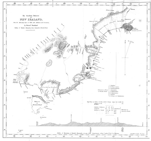
The map facing the title page will, it is believed, give a better general idea of the Southern Districts of New Zealand than any hitherto published. It was first drawn in 1844, to accompany the report on land claims inserted in Appendix II. That portion of the west coast which is distinguished by a dotted line, was taken from the drawing of an intelligent settler, named Meurant, who had passed several years there while as
[Image of page viii]
a sealer; and the track across the island, from the east to the west coast, with the lakes in the interior, was laid down from the sketch and descriptions of a native named Huruhuru, as narrated at pp. 205-6. The remaining coast line, where it differs from that of the Admiralty Chart of 1838, rests on the imperfect authority of the eye and a pocket compass. To take the bearings of headlands, to note down the apparent positions of hills and mountains, and to compute the distance from place to place by means of a watch and the supposed rate of walking, were found to give an additional interest to travelling on foot, when it might otherwise have been wearisome.
It is thought necessary to say thus much of the sources whence the map was derived, to preclude the supposition that any part of it has been borrowed from a map recently published by Mr. Arrowsmith, which resembles it in some remarkable points--particularly in the part given on the authority of the native Huruhuru. That part being founded on a description
[Image of page ix]
either verbal or traced with a pencil, pretends to be only a rude approximation to correctness, and it will therefore, without doubt, be granted that it is next to impossible that the same incorrect outline could be drawn in exactly the same manner by other hands, or even by the same person, a second time; and consequently that, whoever furnished Mr. Arrowsmith with the drawing from which this part, at least, of his map was taken, obtained his information from a copy of the map which was drawn, as stated, in 1844.
The only material alterations made in the map here published are, the outline of Banks's Peninsula, corrected from a chart by Commodore Berard, and hills and mountain ranges, introduced from sketches made formerly, or from memory, in order to give as far as practicable a description of what was seen of the country.
At the end of the volume will be found a vocabulary containing several words and expressions common in the Southern Districts, which differ from those in use in
[Image of page x]
other parts of New Zealand. The author trusts it may be useful, not agreeing with the opinion that to encourage the study of the language of the New Zealanders is to discourage their learning English. On the contrary, he believes, that those who are anxious to teach the New Zealanders English will be better able to do so, having first learned their language. Poor George Primrose went to Holland expecting to make his fortune by teaching the Dutch English; but discovered on his arrival there, that, "in order to teach Dutchmen English, it was necessary that they should first teach him Dutch."
10, Crescent Place, Plymouth, June, 1851.
[CONTENTS]
[Image of page xi]
CONTENTS.
CHAPTER I.
Hakaroa--its Climate--Story of Tamaiharanui and Te Rauparaha--Census of Native Inhabitants--French Company's Claim to Banks's Peninsula--Otakou--Description of the Harbour--its Whale Fishery--Ingenuity of a Sea Bird-- Disease called "tuhawaiki".........................1
CHAPTER II.
Old Pokeni--the "Moko" or Tattoo--not a mark of rank-- Kohi's Tale -- motives which led him to consent to be strangled--The chief Taiaroa -- A Missionary and Police Magistrate deceived--Natives naturally prone to falsehood, but equally ready to confess the truth afterwards--Striking or shooting a person by proxy--A "Kanga " or Curse, very insulting to a Native--Missionaries liable to curse inadvertently--mishap which thus befel a Clergyman--Religious objections of the New Zealander to allow food to touch his head or back--His ideas of the cause of disease--Great value of the stone called " Pounamu "--whence obtained-- how worked--its value in China--its composition.........15
CHAPTER III.
Native Population of Otakou--causes of its diminution--Erroneous opinions as to the general decline of the Aboriginal Population of New Zealand--Edinburgh Review on the sub-
[Image of page xii]
ject--Numerous remains of old Pas no evidence of a former large population--Proportion of Males to Females-- State of Females--Case of Suicide--Health of Natives -- Climate--Cannibalism--Sacred character of a "Taua" or military force--Meaning of the terms " Tapu" and "Noa" --Reasons for believing that the population has increased during the last ten years............................39
CHAPTER IV.
Tuhawaiki's Fleet--his character--skill as a draftsman -- Land Claims--Singular history of certain Title Deeds-Monster claims--Responsible office of the Commissioner --Absentee Natives liable to suffer injustice--Indiscriminate distribution of Crown Grants--to whom beneficial--to whom hurtful....................... 79
CHAPTER V.
Pedigrees of Natives -- Traditionary history--its worth -- Native Lawyers--Claims to Land, how proved by natives --Rights of Females in Land--History of the Southern Tribes--Practical value of Tables of Pedigrees...........92
CHAPTER VI.
Visit Waikouaiti -- Mr. J--'s history -- Mode of paying Whalers--their former drunkenness and improvidence-- present improved moral condition--Tale of Stephen Smith-- Amicable relations of the two races--Mode of grinding and boring holes through the Pounamu stone--Visit Purakaunui--Hospitality of an old whaler--Four notes of the bell-bird..................105
CHAPTER VII. Voyage in a whale-boat -- Coal district -- Perils by sea -- Whaling station at Onekakara--A sick whaler -- Whaling statistics -- Moeraki--Native village--A tragedy--British law applied to natives -- "The Children of Wesley" and "The Church of Pahia"--Bones of the "Moa"........124
[Image of page xiii]
Voyage to the Southward--Molyneux Bay--Wreck of the Brig Lunar--Extraordinary whaling exploit--The Bluff-- Awarua--The Southern Plains -- Koreti or New River -- Whaling station at Aparima--Tuhawaiki's schooner---Ruapuke--A whaler's narrative--Rakiura or Stewart's Island --Shores of Foveaux's Straits--Climate--Eligible site for Colonists.............141
CHAPTER IX.
Sail to Otakou--Journey to the River Taiari -- Expedients in the Bush--The Kotuku--Native village--Disinclination of natives to travel by land--Progress up the river, and return overland--Description of country between Taiari and Otakou--The Scotch settlement Dunedin--its prospects of success--Native pig-preserves--Concluding remarks on the whale fisheries..................165
CHAPTER X.
Preparations for a journey by land to Hakaroa -- "Kouraraki" -- Natives' traditions -- their superstitious dislike to travel by night -- "Tutu" or "Tupakihi"--its poisonous properties -- View from Pukeuri range -- The north-west wind--The River Waitaki--Interview with natives at Te Puna-a-maru....................179
CHAPTER XI.
Encampment on the bank of Waitaki--Mode of preparing fern root--Mokihi--Huruhuru's description of the interior of the island -- Te Pueho's war party -- Te Raki's escape--The River Matau--Wanderings and fate of the war party--Sandals used by natives--Dangers of Waitaki --Resident population--Rakitauneke's oven -- Waihao-- Land and sea breezes.................200
CHAPTER XII.
Travelling on a beach--Unexpected meeting with the Bishop --A deserted whaling station--A native encampment--The
[Image of page xiv]
"Titi" or mutton bird -- Te Rehe--Ninety-mile beach -- Wai-a-te-rua-ti--Harowhenua--Natives' anxiety about the sale of Banks's Peninsula--Census..................219
CHAPTER XIII.
Journey continued--"Kauru" or root of the "Ti"--The River Rakitata--Solitary instance of a scarcity of water in New Zealand--The River Orakaia--Mode of fording rapid rivers--Peculiarities of rivers whose sources are in the Snow Mountains--Taumutu--Tikao's letter--Extremity of the ninety-mile beach--Arrival at Hakaroa..............233
CHAPTER XIV.
The Agent of the French Company and the natives--Wakaoroi (Pigeon Bay)--European settlers--Trespass of cattle --Kokourarata (Port Levy)--Iwikau and Taiaroa--Complaints made by natives regarding forcible occupation of their lands--Visit to Wakaraupo (Port Victoria)--View of the "Canterbury" Plains from the hills above the harbour--Treatment of runaway sailors by natives -- A good example for settlers--Return to Hakaroa.............250
CHAPTER XV.
Second journey to Wakaoroi and Kokourarata -- Tedious voyage in a leaky schooner with the Bishop -- Arrival at Port Nicholson...................272
APPENDIX........................281
VOCABULARY OF THE "KAITAHU" DIALECT........305
[LIST OF ILLUSTRATIONS]
[Image of page xv]
ILLUSTRATIONS.
Map of the Southern Districts of New Zealand, to face title page.
Rauparaha and Rangihaeata, to face page................4
Tuhawaiki's coast-outlines, to face page..................81
In the following order: --Taiari and Rakituma; Aparima, or Jacob's River (Foveaux's Straits); Awarua, or the Bluff Harbour (Foveaux's Straits); East Coast of Stewart's Island.
Genealogical Tables, to face page.......................94
Bay of Waikouaiti, to face page........................139
Map of Lakes in the interior of Middle Island, to face page..........205
[Image of page xvi]
[Page xvi is blank]