GEOLOGlCAL REPORT ON THE THAMES GOLD FIELDS
[Image of page 1]
GEOLOGlCAL REPORT
ON
THE THAMES GOLD FIELDS,
BY
CAPTAIN HUTTON, F.G.S.
Geological Survey Office and Colonial Museum,
(No. 152-67.) Wellington, 23rd September, 1867.
SIR,--
I HAVE the honor to forward, for the information of the Hon. the Colonial Secretary, the Report of Captain Hutton on the Karaka Gold Field, in the Thames District of the Province of Auckland, obtained in accordance with the authority conveyed in your letter of the 28th August last, No. 67-2796.
This Report, I consider, proves satisfactorily the existence, in the district referred to, of gold-bearing formations similar in their nature to those at Coromandel and that, in forming an estimate of the extent to which they are capable of development, the experience of the diggings at that place should be taken as a guide.
The appended extract from my instructions to Captain Hutton expresses my own views on the structure of the adjoining district, founded on observations made in 1864 and 1866.
The association of gold with volcanic rocks belonging to the tertiary period, near the point where they have been erupted through the older palaeozoic slates, has a very important bearing on the question of the occurrence of gold in the interior of the North Island, as there is a probability that many other localities besides the Cape Colville Peninsula will prove auriferous to a similar extent.
I see no reason, however, to expect any extensive alluvial diggings in the Karaka District, or that it will afford a field for the employment of a large mining population.
I have, &c.,
JAMES HECTOR.
The Under Colonial Secretary.
[Image of page 2]
EXTRACT FROM DR. HECTOR'S INSTRUCTIONS.
The range which separates the Thames Valley from the Bay of Plenty, I found to consist of a nucleus of aphanite slates, interbedded with green brecciated and greywacke slates, being part of the upper palaeozoic series. Flanking and capping this nucleus is a great development of the following members of the tertiary series:--
(a). Brown coal formation, very local.
(b). Quartzose gravels, cemented so that they break away in large blocks.
(c). Waitamata series (pliocene).
(d). Trachytic tuff.
(e). Trachytic breccia.
The palaeozoic rocks are cut by dykes of trachyte (granite of the miners), which is charged with auriferous and cupreous iron pyrites.
They, moreover, contain quartz veins, which are also pyritiferous and auriferous. The older rocks decompose very freely to laterite, and the fissures then contain secondary deposits of silica, manganese, &c., especially when near the supposed trachyte dykes, alongside of which in some cases there would seem to have been fissures that were only gradually filled up by deposits from thermal waters, giving rise to the banded, irregular, and crystalline structure of the lodes which is so characteristic of Coromandel.
The composition of the several rocks in the vicinity of the lodes at Coromandel shews their singular character, arising, I suspect, from all the soluble matters of what was once a basic rock having been removed and replaced by silica, and partly by iron pyrites containing gold. That this mineral is the main source of the gold is shown by a section of the lode-ground I made in 1864, when I found that the so-called quartz reefs were contained between two varieties of the pyritous rocks, the sulphurets having been removed from the overlying rock, but still remaining in the lower, the reef itself being a band of mullock containing kernels and geodes of quartz and carbonate of lime, and evidently formed by infiltration.
A third manner in which quartz occurs in the district is in the trachyte tufas, but it is then more chalcedonic and crystalline, and associated with jasper and chert, and is non-auriferous, as proved by the numerous trials at Keeven's Point, Coromandel.
The older rocks present too limited an area in the Coromandel district to form the source of much gold by direct denudation, as in the south of New Zealand; still, where they have been decomposed to form.
[Image of page 3]
the red clay or laterite, and secondary minerals thereby formed, gold may be among these. The gold in the case of Patawai Creek, Coromandel, must have had a different source from the gold got in Driving Creek, as its value was £3 17s. 6d. per ounce, but such deposits seem to be very small and patchy, as only £200 worth was got, I believe, by Mr. Turner, in 1862.
I would not, therefore, recommend as a guide in forming an opinion as to the prospect of gold, the mere presence of absence of palaeozoic rocks, without at the same time taking into consideration their peculiar association with the pyritous rocks above referred to. The same palaeozoic rocks occupy a large area in Otago without a trace of gold, but on the West Coast of Nelson, where they are associated with pyritous felstones and porphyries, they are then auriferous.
I enclose a copy, for your information, of the analysis of the rocks I refer to.
The following points deserve particular attention:--
1. Distinguish carefully the different kinds of quartz.
2. Search for the grey pyritiferous rock in the beds of the streams.
3. Areas where decomposition and siliceous infiltration has affected the rocks, will be recognized by ferruginous springs and by the occurrence of large blocks of the quartz cement, which, though non-auriferous in itself, yet indicates the former agency of thermal springs.
4. Make a rough estimate of the area of alluvium in the district, which could possibly have been derived from the old rocks.
5. Bear in mind that no gravels of miocene age, however purely composed of quartz, have yet proved auriferous, such for instance as the quartz cements along with the brown coal formations.
(Signed) JAMES HECTOR.
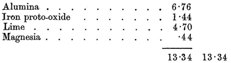
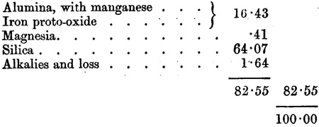
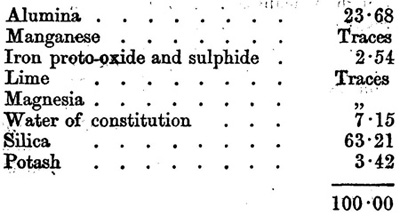
I.--BED ROCK CONTAINING PYRITES, UNDERLYING REEF, NO. 4 CLAIM, COROMANDEL.
As it was impossible to separate the pyrites by washing, the mineral was first treated, after drying at 212 deg., with hot weak hydrochloric acid, to take out any soluble matter. The residue from this operation was then well roasted, and boiled in weak hydrochloric acid. By this
[Image of page 4]
process the pyrites would be decomposed and the iron dissolved. Nothing but iron being found in the acid solution in estimable quantities, its amount was ascertained, and the quantity of sulphide of iron existing in the mineral calculated therefrom. The residue insoluble in hydrochloric acid was finally analyzed.
(1). Analysis of part soluble in hydrochloric acid:--
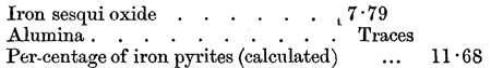
(2). Analysis of part soluble in hydrochloric acid after ignition:--
(3). Analysis of residue from the preceding:--
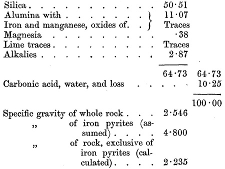
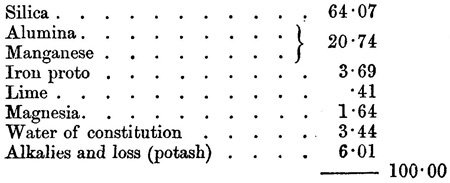
II.--ROOF OR HANGING WALL.
In blow-pipe flame, fuses with moderate ease to a black bead, with no soda reaction. Hygroscopic water, 2.65. Specific gravity, 2.342. Contains neither gold nor iron pyrites.
(1). Analysis of part soluble in hydrochloric acid:--
[Image of page 5]
(2). Analysis of part insoluble in hydrochloric acid:--
(3). Centesimal results, calculated on the whole mineral:--
4). Centesimal results on part insoluble in hydrochloric acid:--
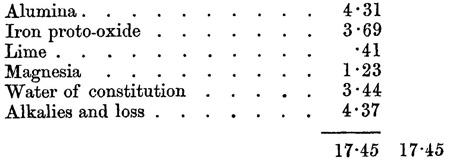
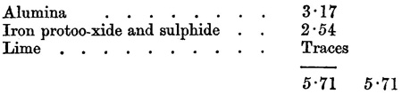
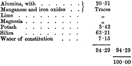
III.--PYRITOUS ROCK. KEEVEN'S POINT.
In blow-pipe flame, fusible with difficulty to a white translucent bead, without any soda reaction. Contains traces of gold.
(1). Specific gravity, 2.348. Hygroscopic water, 5.40
Analysis of part soluble in acid:--
(2). Analysis of part insoluble in acid:--
[Image of page 6]
(3). Centesimal results, calculated upon whole of rock:--
(No. 17 L.)
REEF CEMENT, COROMANDEL.
The black "acicular" crystals consist of sulphide of antimony, and there is also a little iron pyrites present.
(No. 28 L.)
AURIFEROUS PYRITES, FROM KAPANGA, AUCKLAND.
(Submitted for analysis by F. Whitaker, Esq., Superintendent.)
Two samples of auriferous pyrites--reported to have undergone an amalgamating process whereby the quantity of gold originally present had been so much reduced that none could be detected by the naked eye--were submitted, in order that it might be ascertained whether there was a sufficient quantity of gold left, after the above process, in either of the samples, to render profitable its extraction by more exhaustive processes; and the following are the results of the examination:--
No. I.--Sample from auriferous leader, 4.53, oz. of gold per ton.
No. II.--Sample from Kapanga mine, 3.38 oz. of gold. per ton.
No. II. was the coarsest sample, and was admixed to a somewhat greater extent with siliceous matters than No. I., a fact which makes it very probable that the pyrites of this ore is equally rich in gold with that of the other.
(Signed) WILLIAM SKEY, Analyst,
Geological Survey of Kew Zealand.
Laboratory, 12th Jan., 1866.
MEMORANDUM CONCERNING THE ROCK SPECIMENS ACCOMPANYING CAPTAIN HUTTON'S REPORT.
Thirty-eight specimens have been sent to illustrate the geology of the Karaka District, and present a similar character to the rocks from
[Image of page 7]
Coromandel. Among them are three specimens of auriferous quartz from Barry's, Hunt's, and Tookey's claims, in two of which the gold is distinctly seen to form a large portion of the substance of the stone, the matrix being a blue splintery quartz traversed by cracks.
Respecting the specimen from Barry's Creek, which is exceedingly rich, Captain Hutton remarks that it was broken off a specimen picked out from a sack full of stone at random.
Among the specimens sent, in addition to gold, there are samples of lead, copper, antimony; and as the samples previously sent to the Museum, by His Honor the Superintendent of Auckland, contained cinnabar or mercury ore, and as the gold itself contains silver, a great variety of mineral products is thus indicated as occurring in the district.
When several of the specimens have been analysed and compared carefully with the Coromandel specimens already submitted to analysis, the results will be communicated.
Auckland, 17th September, 1867.
SIR,--
I have the honor to report that, in accordance with your instructions, I proceeded to the Thames Gold Field on the 3rd inst. On the 4th and 5th I examined the sluicing operations in the Karaka Creek, and the various auriferous veins that had been discovered in the neighbourhood.
On the 6th I started for a tour to the northward, and examined the whole of the country at present open for prospecting, and went as far as Waipatukau Point, and returned to Shortland on the 10th instant.
On the 11th I sailed with Mr. Commissioner Mackay, for Auckland, in his cutter, and arrived there at 2 a.m. on Sunday, 15th instant.
I enclose my report on the district I visited, together with a map and section.
I also send by the same steamer (Airedale) that takes this report, a box containing specimens of rocks and minerals, and three photographs.
I have, &c.,
F. W. HUTTON.
Dr. Hector, F.R.S.,
Director of the Geological Survey of New Zealand, Wellington.
[Image of page 8]
REPORT ON THE GEOLOGY OF THE THAMES GOLD FIELDS.
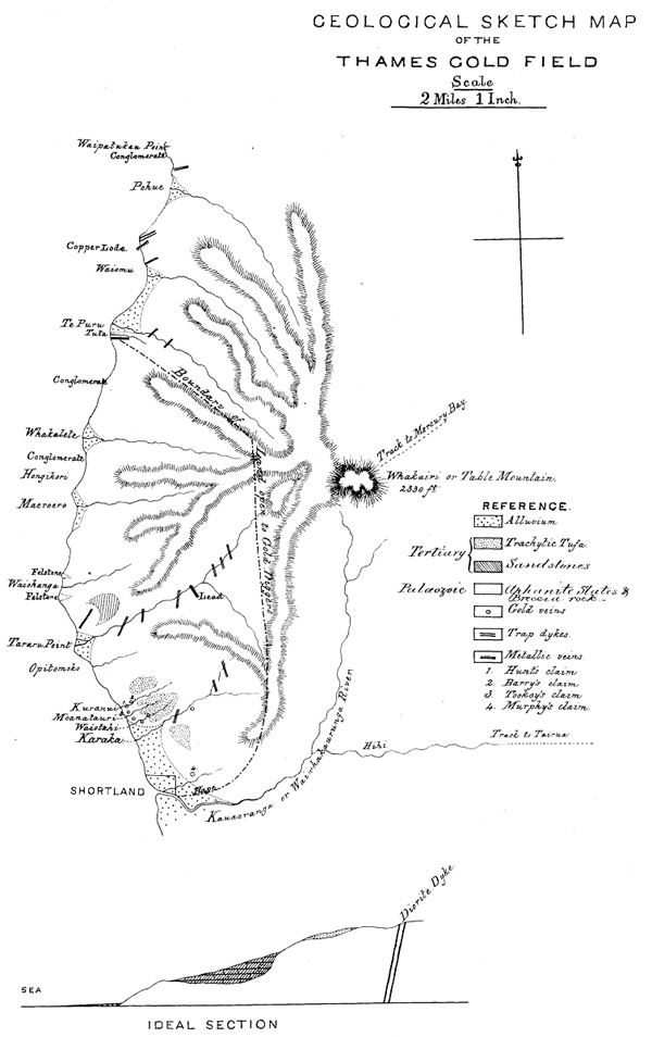
DESCRIPTION OF COUNTRY.
The tract of country at present open to Europeans for gold prospecting in the Thames, commences at the mouth of the Kauearanga River, and runs north for about nine miles, as far as the Tuta Creek, with a breadth of about four miles: thus making the total area open, about thirty-six square miles.
The whole of the country is much broken, rising, except at the mouths of four of the streams, into hills of from 600 to 800 feet close to the sea, and increasing in height towards the eastern boundary of the block, to more than 1,000 feet. The country is for the most part covered with dense bush, (except where close to the sea); and the streams are all mountain torrents, with large boulders occupying their beds.
GEOLOGICAL STRUCTURE.
The geological structure of the country is very simple, being almost entirely composed of a huge mass of trachytic tufa, resting on palaeozoic rocks, which are cut by numerous dykes, mostly of diorite, but occasionally of trachyte. This tufa appears generally as a softish grey coarse-grained rock, weathering white, and sometimes much stained with peroxide of iron. Where cut by dykes, it is hardened for considerable distances, and much altered in appearance. As might be expected, however, from its origin, it varies a good deal in character: often containing rounded blocks of diorite one or two feet in diameter; indeed, in three or four places it passes into a true conglomerate, while occasionally small angular stones are seen in it, forming a breccia. These latter, however, are very local.
Near Hongikori the rounded blocks of diorite are encased with a coating of red jasper.
The rock is also traversed by numerous veins of quartz, carbonate of lime, or both these minerals mixed together, in which case it is seen that the carbonate of lime is a subsequent introduction, as it is found encrusting well-formed crystals of quartz.
The whole of the rock, including some of the dykes, is much impregnated with iron pyrites, generally in the form of minute cubes, but decomposed to a grey powder near the auriferous veins.
GOLD VEINS.
Auriferous quartz veins had been found in eight different localities
[Image of page 9]
on the 11th September. The gold is similar in character to that found at Coromandel.
HUNT'S REEF.
Hunt's "reef," as it is called, is a mass of trachytic tufa, over which the water of the Kuranui Creek falls. The face thus exposed is traversed by four small, nearly vertical, veins of quartz with gold, running N. by E.
BARRY'S REEF.
Barry's "reef," about 100 yards higher up the creek, is a vein of mullock about a foot thick, dipping 70 degrees W. The gold occurs generally in more or less rounded nodules (like flints in chalk) of quartz, some of which are very rich. This vein is exposed on the right bank of the creek for a distance of about 15 feet.
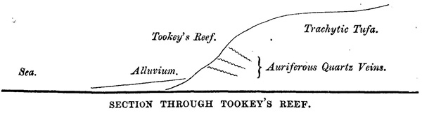
TOOKEY'S REEF.
Tookey's "reef" consists of a series of small veins of auriferous quartz, dipping 50 degrees N.W. It is situated about 220 feet above the level of the sea, on the side of a hill of trachytic tufa, between the Kuranui and Moanatauri Creeks.
COPPER.
A little north of Wainui, a lode of copper occurs, below high-water mark, running N.N.E. into the hills, where, however, owing to the vegetation, it cannot now be seen. The ore here appears to be a mixture of iron and copper pyrites, like that at the Kawau, with some red oxide. The specimens sent have been lying on the beach for some time. This lode also occurs in the tufa. Small specks of copper pyrites often occur together with iron pyrites in the quartz veins traversing the tufa.
LEAD.
About two-and-a-half miles up the Tararu Creek, in the tufa, hardened by its proximity to a dyke of diorite, a quartz vein occurs with crystals of galena, dipping 70 degrees N.N.E.; and in one of the claims now being worked in the Waitohi Creek, crystals, more than an inch long, of stibnite (sulphide of antimony) have been found embedded in the tufa.
[Image of page 10]
AGE OF TUFA.
This tufa is probably of tertiary age, and not older than the Waitemata veins.
STRUCTURE.
There are no marks of bedding nor stratification to be seen, but from the extent of country that it covers, and the general vertical direction of the dykes, I think that it is not far from horizontal, dipping probably slightly to the west or north-west. The absence of slate boulders in the streams and on the coast, seems to show that this tufa extends over much more ground than that visited by me, and I can see no reason why auriferous veins should not be found in any part of it. These veins, being thin and variable, must always render gold-mining in this district highly speculative, and if, as I believe, the stratification is nearly horizontal, deep sinking will be useless, and, in order to enable a company to make a profit, it will require more ground than that usually allotted to a gold claim.
PALAEOZOIC FORMATIONS.
In one locality only, between the Tararu and the Waiohanga Creeks, are palaeozoic rocks seen in the district. They here consist of blue arenaceous slates, covered by a fine-grained felsite tufa, the whole dipping 35 degrees S.W.
TERTIARY TRACHYTIC TUFA.
Lying on the tops of the old tufaceous hills, between Shortland and Tararu, a deposit of a fine red and white trachytic tufa is seen, of a much later date than the old one on which it rests. This does not cover much extent of country, and is probably of pleistocene age, and formed by the former eruptions of Aroha Mountain.
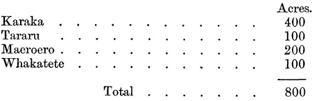
ALLUVIUM.
The largest quantity of alluvium in the district is that between the Kauaeranga and Kuranui streams. This I estimate to cover an area of 700 acres, out of which 100 acres must be deducted for the township of Shortland, and 200 more for tapu burial-grounds, leaving 400 available for diggers. This tract may be considered as an incline sloping up from the sea to a height of forty feet at the foot of the hills. It is an old sea's beach, covered, where the creeks debouch into it, by recent fluviatile accumulations.
SLUICING.
These latter, at the Karaka, have been worked by sluicing pretty
[Image of page 11]
systematically for the last three weeks, and the results have not been satisfactory. The gold is of the same description as that found in the veins, but associated with minute grains of cinnabar and magnetic iron-sand; it appears to be greatest in quantity in the upper three feet of the deposit, and but little has been found among the larger boulders below this depth.
RESULTS, KARAKA CREEK.
The best results that I heard of in the Karaka, were half-an-ounce in three days with one sluice-box.
WAIOTAHI CREEK.
Since then better prospects have been obtained in the Waiotahi Creek, but not, I think, sufficient to justify the opinion that payable alluvial gold exists there in any quantity.
BRITISH CLAIM.
A shaft, the British claim, is now being sunk by subscription, in the flat at the embouchure of the Karaka, with the intention of bottoming the alluvial deposits. No gold has been found, as yet, during the sinking, and as the bottom, when reached, will be an old coast line sloping probably seawards, there is no reason for hoping that gold will reward their labors.
TARARU.
The alluvial deposits at the mouth of the Tararu is about 150 acres, one-third of which is Maori cultivation, and could not be touched.
MAEROERO.
At the mouth of the Maeroero, 300 acres, 100 of which are tapu; and at the mouth of the Whakatete, about 300 acres, two-thirds of which are burial grounds and tapu. Thus the whole of the alluvial deposits in the district available for gold-mining purposes are--
This, of course, does not include the small quantity of alluvium up the beds of each of the creeks.
Judging from the smallness of the particles of gold found, and that it occurs most plentifully in the upper portion of the alluvium, I am of opinion that the greater part of the gold broken off from the veins by
[Image of page 12]
the streams, is carried out to sea before it has had time to clear itself from the quartz matrix; that fine projecting particles of gold are rubbed off during the passage of the quartz down to the sea, in the ordinary state of the stream, and are deposited in the upper part of the alluvium; but the first considerable fresh clears out all these deposits and takes them out to sea, and on the subsidence of the water to its ordinary flow, they have to begin again to accumulate, until they are again swept away.
Gold is reported to have been also found in the Puru, Whakatete, Waiohanga, and Tararu streams.
F. W. HUTTON.
[Inserted unpaginated illustration]