CHAPTER II: New Zealand. Sketch of its physical Structure
[Image of page 33]
CHAPTER II.
New Zealand. Sketch of its physical Structure.
Position. -- Area and shape. -- Name of Islands. -- The South Island. -- The Southern Alps. -- Physical features and natural scenery. -- West coast. -- East coast. -- The North Island. -- Continuation of the Southern Alps. -- Volcanic zones. -- Taupo zone. -- Auckland zone. -- Bay of Islands zone. -- Harbours.
On the opposite part of our globe, and just below our feet -- nearly 180 deg. long, distant from us, and as far to the South of the Equator as Italy is to the North of it -- there lies in the South Pacific Ocean, between the Australian and S. American Continents, a country, of which Tasman, in the middle of the 17 century, brought the first tidings to Europe. The Dutch named it New Zealand. 1 A marvellous country it is, that land of our Antipodes, where people - as we used to think when children -- walk with their feet towards us, and their heads downwards: "all upside down," because,
[Image of page 34]
as we had heard at school, it is winter there, when we have summer; and day there, when we have night. Of course, these facts appearing so very contradictory within the limited range of our childish comprehension, have long since lost every trace of strangeness with the advance of a maturer age; but nevertheless New Zealand still remains to us a most wonderful country.
Far from all continental shores, and out of the limits encircling the numerous clusters of islands in the equatorial zone of the Pacific Ocean, it towers amid the greatest mass of waters ou the face of the earth, washed by the ever restless waves of the vast ocean; more isolated than any other land of equal extent.
Not inhabited probably till within late centuries of the history of man, and then but thinly populated, and only along the coasts and along the banks of navigable rivers, -- New Zealand has fully preserved within its interior, the originality and peculiarity of its remarkable animal and vegetable kingdoms up to our present time. No monuments of any kind; no tombs of kings, no ruins of cities, no time-honoured fragments of shattered palace-domes and temples, are there to tell of the deeds of ages or nations past and gone. But Nature, through her mightiest agencies, through fire and water, has stamped her history in indelible characters on the virgin-soil of the island. The wild Alpine heights of the South, towering in silent grandeur to the sky, their lofty summits crested with fields of ice and decked with glacier-robes; the Volcanoes of the North looming up into the regions of perpetual snow, glisten from afar, dazzling the wondering eyes of the mariner, as he approaches the coast. Fertile and well-watered alluvial plains are there awaiting the enterprising settler, -- the virgin-soil, on which he founds a new home; a land, blessed with the most genial climate, where he has but to battle with and subdue the wilderness to reap the never failing fruits of his labours.
New Zealand consists of two largo and several small islands, forming a broad stripe of land extending from South-west to Northeast, the North-end of which is prolonged by a narrow peninsula running in a north-westerly direction. Its outlines are very similar
[Image of page 35]
to those of Italy in a reversed position. It lies between the parallels 34 1/2 deg. and 47 1/2 deg. South-latitude, and the meridians 166 1/2 and 178 3/4 deg. long. East of Greenwich. Its length is 800 sea-miles from North to South; which extent, if measured on European soil, would reach from the Southern extremity of Italy far over the Alps to the vicinity of Munich. The mean width from East to West is 120 sea-miles, and the area of the whole group of islands has been estimated by Dr. Petermann at 99,969 Engl. sq. miles (or 4703 German sq. miles). 2
Hence New Zealand is about as large as Great Britain and Ireland, or four times as large as the ancestral estates of the Roman Empire in Italy; an area extensive enough to fit it in future for a maritime state destined to extend its sway around -- a "Great Britain of the South-sea." 3
If we moreover contemplate the situation of New Zealand, as it appears upon a planiglobe on Mercator's projection, we find it almost in the centre of an immense semi-circle dividing the globe,
[Image of page 36]
from the Cape of Good Hope to Behring Strait in the Old World, and from Behring Strait to Cape Horn in the New World. Such is the situation of "Young Albion of the Antipodal World."
Two arms of the sea, Cook Strait in the North (41 deg. N. lat.) and Foveaux Strait in the South (46 deg. 40' N. lat.) divide New Zealand into three parts of different sizes; two larger islands, which for want of better names have been designated in geography as North Island and South Island; and a third, small island, favoured with the special name of Stewart's Island. 4
The three islands constitute only parts of one and the same system of mountains, which running from South-West to North-East forms a distinctly marked line of elevation in the Pacific Ocean. This longitudinal line is crossed by a second almost at right angles, which is indicated by the direction of Foveaux and Cook Straits, but still more so by the direction of the long-stretched N.W. peninsula of North Island; 5 this N.W. peninsula corresponds to the line, striking to N. 52 deg. W., and designated by Dana 6 as the axis of the greatest depression in the Pacific Ocean.
Dana observes that a line drawn from Pitcairn's Island
[Image of page 37]
(Paumotu group) in a westerly direction, to the North of Society Islands, past Samoa and Salomon Islands as far as the Pelew Islands (East of the Philippine Islands), is pretty nearly the boundary-line between the Low Islands or Atolls to the North, and the High Islands to the South. He designates the extensive sheet of water between said line and the Sandwich Islands, -- an area, nearly 2000 sea-miles wide and 6000 long, and studded with, nearly 200 low Coral Islands, -- as one vast area of depression. Nearly all the groups of islands in this area have a north-westerly course, and an imaginary line drawn from Pitcairn's Island in a north-westerly direction to N. 52 deg. W. as far as the Japanese Islands, would be the mean-line of that field of depression, or the axis of the greatest depression. But on actually drawing this line upon a map on Mercator's projection, wo shall find that a line drawn from Pitcairn's Island to N. 45 deg. W., -- its north-westerly prolongation touching precisely the North-coast of the Japanese Island Yezo, -- would constitute perhaps with still more correctness the mean-line of that area of depression. If moreover according to the mean direction of the Southern Alps, the highest mountain-range upon the Isles of the South-sea, we imagine a line running in the direction of N. 45 deg. E. as the mean longitudinal direction of New Zealand, the two lines, viz. the above mentioned line of depression and this line of elevation intersect each other at right angles. Noteworthy is the circumstance that the general geological importance of those two directions in the Pacific Ocean displays itself also in the direction of the eastern coast-line of the Australian continent. The East-coast of Australia and the Westcoast of New Zealand form lines very nearly parallel; their distance about 1000 sea-miles. To the north-easterly direction of the line of elevation there correspond upon New Zealand also the principal eruptions, plutonic as well as volcanic; to the north-western line of depression, on the other hand, the transverse ruptures, by which Foveaux and Cook Straits were formed, and a third dislocation, to which the N. E. coast-line of North Island owes its origin.
The most striking and important feature of New Zealand is
[Image of page 38]
an extensive, longitudinal mountain-range, which, interrupted by Cook Strait, runs through the whole length of the two larger islands in the direction of S.W. to N.E., from the South Cape to the East Cape. This range, consisting of upheaved zones of stratified and massive rocks of different ages, constitutes the powerful back-bone of the islands. At its foot, -- on South Island at the eastern foot, on North Island at the western (perhaps partly also at the eastern), --- it is accompanied by a volcanic zone, on which abysso-dynamical forces have acted powerfully till within the most recent periods of the earth, The volcanic outbursts, forming an extensive table-land of volcanic tuff, from which isolated cones arise, together with sedimentary formations of the tertiary and quartary period, gave the islands but very recently their present form; which, however, still continues to be subject to various sudden and periodical changes, in consequence of earthquakes, as well as secular elevations and depressions.
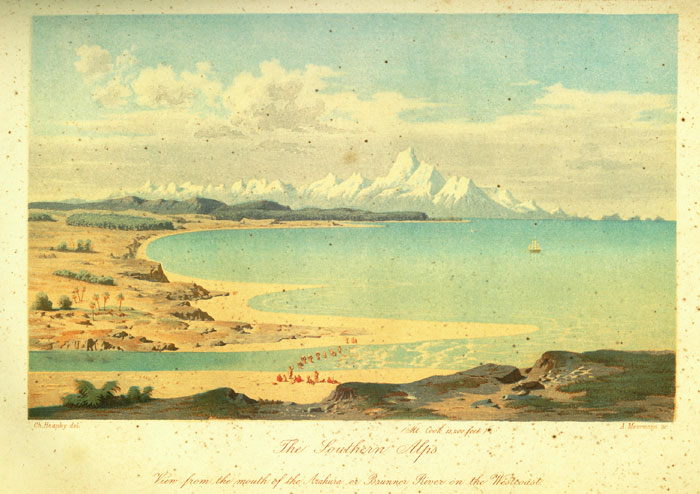
The main range attains its grandest development on South Island. Here its numerous peaks capped with perpetual snow and decked with glacial shrouds impart to it a truly Alpine character, justly entitling it to the name of the "Southern Alps". High, precipitous, craggy mountain-ranges, intersected by narrow longitudinal valleys, run parallel to each other from Foveaux Strait to Cook Strait; they are connected by transverse ridges, and intersected by the deep transverse valleys of the various rivers. In the centre of this range are seen towering up in majestic grandeur the peaks of Mount Cook, Mount Tasman and the adjacent mountain giants, glistering with perpetual snow and ice, to a height of 13,000 feet above the level of the sea, almost as high of Mont Blanc. Splendid glacier-streams, lovely mountain-lakes, magnificent cataracts, mountain-passes and gloomy ravines with roaring mountain-streams rushing through, -- such are the charms of a wild and uninhabited alpine region, but seldom trodden by human foot; a scenery so grand, that according to the enthusiastic reports of the travellers, who ventured to penetrate into this wilderness, it scarcely has its equal anywhere.
Towards the West this range of mountains sinks abruptly, leaving
[Inserted page with illustration]
[Image of page 39]
only a narrow slip of fertile land between its base and the sea, or forming vertical precipices, in some places from 3000 to 4000 feet high. Only where the outlines of the coast cease to run parallel with the mountains, taking a course across the axis of the range, the coastline is indented with deep inlets and sounds, which extend far into the land between the high mountain ridges. Such is the case in the South from Milford Haven as far as Foveaux Strait, and in the North on Cook Strait from Cape Farewell to Cape Campbell. At these two extremities of South Island are those capital harbours situated, such as Dusky Bay in the South, and Queen Charlotte Sound in the North, which have been the safe places of shelter for the bold seafarers, who first ventured out to these distant shores.
Very different are the features on the East coast. The attention of the scientific observer has been quite correctly drawn to the close resemblance between the formation of the coasts of New Zealand and of South America (Patagonia and Tierra del Fuego); as also to the general fact, so very obvious in New Zealand, that the destructive tendency of the sea displays itself principally on the West and South-West-coasts of islands and continents, continuing to wear away the land until it reaches a powerful mountain-range, which then serves as a bulwark for the low lands and plains at its eastern foot.
At the foot of the range on the East-side runs a long row of trachytic cones varying in height from 3000 to 6000 feet above the level of the sea (Mt. Sommers 5240 feet; Mt. Hutt 6800 feet; Mt. Grey 3000 feet etc.); the inland Kaikoras on the North East-side of the island reaching the considerable height of 8000 to 9000 feet. These caps and cones consisting of trachyte, andesite and phonolite, surrounded with extensive deposits of tuff and amygdaloid, 7 and without the least trace of crater formation or of lava streams, present a remarkable line, -- parallel with the axis of the mountain, -- of eruptions belonging probably to the tertiary era.
[Image of page 40]
Parallel to this line of eruption, and likewise in the direction from S.S.W. to N.N.E., but a little more Eastward, there runs a second zone of newer volcanic eruptions. To it belong the groups of volcanic mountains built up of doleritic and basaltic lava streams, and varying in height from 2000 feet to 3000 feet above the level of the sea, which project peninsula-like from the East coast far into the sea, their deep craters open towards the sea, constituting the only safe harbours on the East-side of the South Island. This is Banks' Peninsula with the four harbours, Port Cooper, Levi Bay, Pigeon Bay, Akaroa, and Otago Peninsula with Otago Harbour. On South Island, however, volcanic action has entirely ceased according to observations hitherto made. Some hot springs recently discovered in the Kaikoras may perhaps be considered as its last struggling efforts.
Between the trachytic and basaltic zones, there are extensive plains and alluvial tracts most admirably adapted to agriculture and pasturage. They attain near the base of the mountains a height of from 1500 to 2000 feet above the level of the sea, are in some parts 40 miles wide, and slope gently towards the sea, where they are bordered by a long lino of sand-hills. They are crossed by numerous mountain-streams, which bring large quantities of detritus from the mountains, rolling them in broad shingle-beds into the sea. In these plains, especially in the vicinity of Christchurch, Fata. Morgana, -- mirages, -- are of no rare occurence. The sea on one side, and the mountains on the other, seem to approach together, and ti-trees (cordyline australis) on the plains are seen inverted.
On North Island, on the other side of Cook Strait, the mountain-range extending along the East-coast from Cape Palliser to East Cape, is to be considered as a continuation of the Southern Alps, -- at least of their eastern ranges. The various parts of it, such as the rugged forest ranges of Tararua, Ruahine, Toha-wera, Kaimanawa, Tewaiti, fall far short of the height of the Southern Alps, -- their highest peaks attaining a height of only 5000 to 6000 feet -- and are almost a terra incognita, that may
[Image of page 41]
conceal yet many an unexpected treasure. 8 Whether the zone of trachytic eruptions on South Island has likewise a northerly continuation on the East-side of this mountain-range, future researches must determine. Perhaps the conical peak Mount Hikurangi (5500 feet) near East Cape, so celebrated in the legends of the natives, is such a trachyte or andesite-dome.
Nevertheless the northern Island abounds in volcanic phenomena of every kind. The table-land on the Westside of the mountain-range, sloping off gradually towards North and South and constituting the remaining portion of North Island, is perforated in more than a hundred places by the volcanic forces from below, which have continued their operations to this very day.
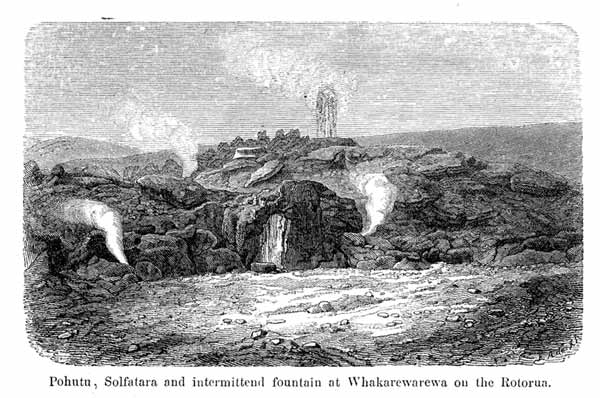
High trachytic cones of volcanic character; a largo number of smaller basaltic cones of quite recent geological date; a long row of hot springs and steaming fountains, which, intermittent like the geysers upon Iceland, eject at shorter or longer intervals masses of seething water high into the air; fumaroles and solfataras of the grandest variety, afford the geologist a rich field of observation, and the traveller a series of sights the most remarkable in nature. No wonder then, that these striking, far-famed phenomena, -- the peculiar nature of which was as well comprehended by the very first settlers even without a minute geological knowledge, as by the natives, -- led to the general supposition that the soil of New Zealand is principally of volcanic origin.
In reality, however, the volcanic formations on North Island are limited to three separate districts, or to three zones, which, -- different from the volcanic zone of South Island situated on the East-side of the Southern Alps, -- lie all west of that range of mountains, which may be considered as a continuation of the Alps on North Island.
Immediately contiguous to that northern range of mountains is the great central zone; I call it the Taupo Zone. It contains the grandest and rarest volcanic phenomena that New Zealand can boast
[Image of page 42]
of. Quite close to the centre of the island, on the southern shore of the large inland-lake Taupo, the waters of which fill a deep reservoir upon a sterile pumice-stone plateau of about 2000 feet above the level of the sea, the two giants among the volcanic cones of New Zealand, Tongariro and Ruapahu rear their colossal heads. The Tongariro volcano, 6000 feet high, with two powerful, ever steaming craters, is still active at least as solfatara; the Ruapahu on the other hand, which is over 9000 feet high and covered with perpetual snow, appears to be totally extinct. These two mountains are surrounded by a number of smaller cones, likewise extinct, such as Pihanga, Kakaramea, Hauhanga and others, which the natives call the wives and children of the two giants. A third giant, -- so says tradition, -- named Taranaki, stood formerly beside Tongariro and Ruapahu; but having quarrelled with the latter he was obliged to flee to the West-coast, where, a lonely exile on the coast, he now rears his hoary head amongst the clouds; this is the snow-capped Taranaki or Mount Egmont, 8270 feet high.
The two principal rivers of the North Island, rising near the Tongariro and Ruapahu, are the Waikato flowing North, and the Wanganui running South into the Cook-Strait. The land, consisting wholly of quartzose trachytic rocks, -- recently termed rhyolite to distinguish them from the common trachytes, -- and of pumice-stone, slopes from the foot of those mountains gradually to the northeastern coast at the Bay of Plenty. A few miles from this coast lies the small island Whakari or White Island, 863 feet high, the conical peak of which, visible at a great distance by its continually ascending white clouds of steam, contains the second active crater of New Zealand. The distance from Tongariro to the Whakari Volcano is 120 nautical miles. Over this whole distance, almost on the very line between these two active craters, it seethes and bubbles and steams from more than a thousand crevices and fissures, that channel the lava-beds, of which the soil consists, -- a sure prognostic of the still smouldering fire in the depths below -- while numerous freshwater lakes, of which Lake Taupo, twenty
[Image of page 43]
miles in diameter, is the largest, fill up the larger depressions of the ground.
This is the "Lake District" in the south-eastern portion of the Province Auckland, so famous for its boiling springs, its steaming fumaroles, solfataras, and bubbling mud-basins, or as the natives call them, the Ngawhas and Puias. 9 Till now, none but missionaries, government officers and some few tourists have ventured by the narrow Maori paths through bush and swamps to visit this marvellous region; but all who have witnessed with their own eyes the wonders of nature displayed here, were transported with amazement and delight.
Only the natives have hitherto made practical use of those hot springs, which are the grandest in the world, and sought relief in them for their various complaints and diseases. But when once, with the progressive colonization of New Zealand, these parts have become more accessible, then thousands dwelling in the various countries of the Southern Hemisphere, in Australia, Tasmania or New Zealand, will flock to these paints where nature not only exhibits such remarkable phenomena in the loveliest district with the best and most genial climate, but has also created such an extraordinary number of healing springs.
The other two volcanic zones, -- although now entirely extinct, yet decidedly of a later period than the Taupo zone, -- belong to the long-stretched and singularly shaped north-western peninsula of North Island. I have designated them as the Bay of Islands zone and Auckland zone; the latter with no less than 63 points of eruption, rendering the narrow isthmus, that joins this peninsula to the main-body of North Island, a truly classical soil for the study of volcanic formations.
The Bay of Island zone comprises a number of smaller, extinct volcanic cones, situated on the northern half of the peninsula,
[Image of page 44]
between the Hokianga River West and the Bay of Islands East, and fully corresponding as to their geological character with the Auckland volcanoes. Some few hot springs and solfataras south of Waimate in the Otoua district are the final effects of volcanic action in this zone.
North Island, like its southern mate, has its best harbours at its two opposite extremities; Port Nicholson, the harbour of Wellington on Cook Strait in the South, and the numerous harbour bays on the East coast of the northern peninsula from North Cape to Cape Colville, among which the Bay of Islands, and the Waitemata or Auckland Harbour are the most important. All the harbours on the West coast of North Island have sandbars at their entrances, and Manukau Harbour is the only one accessible to larger vessels.
On looking over the numerous colonies of great and glorious Albion, -- that vigorous, parent tree, the branches and saplings of which are taking root and thriving in all parts of the world, -- and comparing them with New Zealand, it is at once evident, that of all the colonial provinces of the British crown, New Zealand
[Image of page 45]
bears the most resemblance to the mother-country by virtue of its insular position, its climate, its soil, and the whole form and structure of the country. It is an empire of islands, a double island, which, -- thanks to the power of steam, that now-a-days shortens every distance, -- lies towards the neighbouring Australian Continent, 10 like Great Britain towards Europe. Blessed with a genial oceanic climate, so admirable suited to the Anglo-saxon race; with a fertile soil well watered and splendidly adapted to agriculture and farming; with a manifold coast-line, suiting perfectly to the notions and habits of the first maritime nation of the world: it is a country without dangerous animals, without poisonous plants, but rich in mineral treasures; a country where horses, cattle and sheep thrive; where fruit, grain and potatoes grow most abundantly; a country adorned with all the charms and beauties of grand natural scenery; a country which can easily support a population of 12 millions; which promises the bold and persevering immigrant a lucrative and brilliant future. Such a country appears indeed destined before all others to become the mother of civilized nations.