CHAPTER XIII: Round the Manukau Harbour and to the Mouth of Waikato River
[Image of page 258]
CHAPTER XIII.
Round the Manukau Harbour and to the Mouth of Waikato River.
Onehunga. -- Rev. Mr. Purchas. -- The Manukau Basin. -- Whau-Bay. -- Volcanic rocks. -- Magnetic iron-sand. -- Taranaki-steel. -- Huia Bay. -- Saw-mills. -- Maori path through the bush. -- The pilot-station. -- Character of the West coast. -- The weather. -- South head of the Harbour. -- Kauri Point. -- Schooner "Sea Belle". -- Waiuku. -- Lignite. -- Caravan of Maori traders. -- Te Rata Hokitata. -- Collections. -- Formation of sandstone banks from quicksand. -- Mouth of the Waikato. -- North and South head. Discovery of Belemnites. -- Queen's road. -- First view of Mount Egmont. -- Maori mail. -- Fossil ferns on the West coast. -- Awaroa Creek. -- From Waiuku to Mauku. -- Farmhouses blessed with daughters. -- Return to Auckland.
Captain Wing, the obliging pilot of Manukau Harbour, had offered me his excellent whale boat, for a cruise upon the waters of the Manukau, and promised to accompany me with my friends, the Rev. Mr. Purchas and Captain Ninnis of Onehunga. Our place of rendez-vous was Onehunga. I had made my appearance there two days previous, for the purpose of roaming, in company of Mr. Purchas, over the environs of the town. Before I begin to the describe the country, I may be allowed to dedicate a few lines to the cherished memory of that noble-hearted man. Endowed with an extraordinary talent of observation, and exerting himself with an untiring zeal and energy in the most different directions, Mr. Purchas has rendered great services to the colony by the share, justly due to him, in the discovery and management of the coalfields in the vicinity of Auckland, as well as by the invention of a new method
[Image of page 259]
of preparing from the leaves of Phormium tenax, the well-known New Zealand flax, so highly valued for its durability and tenacity. That worthy man attends with equal credit to his spiritual functions; and Onehunga is indebted to him for a beautiful school-house built of massive basalt-stone. In his agreeable company I spent many a pleasant day, and in the circle of his amiable family I passed many a happy evening. Whenever I went to visit the cheerful parsonage, homely situated in a small garden, I was always certain to meet with some little surprise; for the children also, after the example of their energetic parent, rivalled each other in industry for collecting curiosities, and had always something reserved for me, such as butterflies, beetles, or shells. Thus I am indebted to his family for many friendly services and also for valuable contributions to my collections.
Manukau Harbour 1 presents a very extensive sea-basin, hemmed in on the North by hills, on the South and East by low flats; its diameter is from 12 to 15 miles. It is crossed by three navigable channels: the Onehunga, Papakura, and Waiuku Channels leading to creeks of the same names, which recede far back into the country. The mail-steamers come to anchor in the Onehunga Channel at White Bluff, a few miles West of Onehunga on the North-side of the harbour. Papakura Creek leads to the immediate vicinity of the coalfields at Drury, and Waiuku Creek is the route to the Waikato country. At neap-tide the shallow mud and sandbanks between the channels become dry; at flood-tide, however, the water rises from 10 to 13 feet. Ebb and flow, and the prevailing Westwinds, cause the water to be in continual motion; the Manukau is, therefore, noted for being a boisterous water. As the harbour is frequented only by the mail-steamers and small coasting-cruisers, it is quite dull in comparison with Auckland Harbour; on the other hand, during calm weather, numerous canoes of the natives are to be seen passing between the Maori settlements along its shores.
[Image of page 260]
Captain Wing having been detained by his pilot-duties at the departure of the mail-steamer, it was not until January 18, that we could begin our excursion. The weather was extremely favourable; there was a perfect calm. The fogs, which in the morning had covered, like a pall, that low flat region, had passed away by 7 o'clock, and the sun looked cheerfully from the cloudless sky upon the placid watery mirror of the Manukau Gulf. A better day we could not have desired.
We embarked from the Onehunga pier; five natives managed the oars, and with Captain Wing at the helm, we drove along the Northcoast of the harbour. The banks break off in steep declivities, presenting regular strata of sandstone and shale, and with here and there small seams of lignite at the water's edge, exactly as on the banks of the Waitemata. The strata lie mostly horizontal, local disturbances, such as at Matinga Rahi Point (Cape Horn), excepted. Opposite, on the southern shore, rises the volcanic cone Mangere, the volcanic island Puketutu (Weekes Island), and the smaller cones about Tumatoa Point.
In Whau Bay we had reached that point, where Whau Creek, a long narrow South-branch of the Waitemata cuts so deeply into the Auckland Isthmus, that the whole breadth between the two harbours amounts to but little over one mile. As the land is moreover very low -- its highest point being only 111 feet above the level of the sea -- the colonists have repeatedly entertained the project of connecting the two harbours by a canal; and, towards the execution of this plan, a benefit rather than disadvantage might arise from the fact, that ebb and flow do not take place at the same time at the East and West coasts; the flow being later on the West coast by three hours than on the East coast. From Whau Bay the coast, intersected by Little Muddy Creek, Waikumate and Big Muddy Creek, extends in a southwesterly direction to the long and keenly jutting peninsula Puponga. The land here begins to rise, and the mountain-ridges of the, Titirangi Chain extend their wood-clad spurs as far as the coast.
On the North-side of the Puponga peninsula, in a small inlet,
[Image of page 261]
we went ashore, and encamped for dinner under the shade of a magnificent Pohutukaua tree (Metrosideros tormentosa), the trunk of which measured 24 feet in circumference. In the back-ground rugged cliffs of a most remarkable appearance are seen. Tremendous blocks of volcanic rocks, of trachyte, andesite and basalt -- blocks of 4 to 6 feet diameter, angular and sharp pointed, and of all colours, red, green, brown and black -- are cemented together into a conglomerate or breccia, forming huge masses of solid rock, in which, nevertheless, a rude stratification may be observed. From some of those blocks I succeeded in knocking out neat crystals of pyroxene. Here we have the commencement of those strata of volcanic conglomerate and breccia which, more than 1000 feet thick, compose the Titirangi Chain, and from the Manukau Northhead stretch as far as close to the Kaipara Harbour, forming the rugged, rocky precipice of the Westcoast. 2 Proceeding along the beach of Puponga peninsula in a N.W. direction to Karangahape Bay, upon the banks of which, on a less favourable site, a township, called Cornwallis, has been laid out -- of which, however, as yet, not a single house stands -- the lower strata appear; first banks of a soft, rusty sandstone, which is sprinkled black with fine grains of magnetic iron; and farther on layers of sandstone and shale, such as the Isthmus of Auckland is composed of. One is able to convince oneself here, that the violent convulsions, which formed those colossal masses of volcanic conglomerates, are of a more recent date, than the formation of the tertiary strata on the Waitemata. Here also, in several places of the beach, black titaniferous iron-sand has been found of the same description as the iron-sand, which is an ingredient of the sand along the whole Westcoast of the northern Island; which especially on the coast of Taranaki covers the shore for miles, and which, according to experiments made with it in England, is said to produce most
[Image of page 262]
excellent titanium steel. 3 The iron-sand here has evidently its origin in that rust-coloured, crumbling sandstone, which rises along the shore in banks measuring from 10 to 20 feet and is washed out by the breaking of the surge. The original mass, however, by the decomposition of which the grains of magnetic iron were mixed with the sandstone, must be a volcanic rock of prior date.
The peninsula of Puponga protects the interior portion of Manukau Harbour against the waves of the ocean, which penetrate between the "Heads" far into the outer portion of the harbour, and are broken on the Westside of the peninsula. We passed over the low ridge of the peninsula. The boat was awaiting us on the other side, and thence we crossed over to Huia Bay, where, close by the seashore, upon the dry sand of the beach, we pitched our tent, for the purpose of camping through the night.
January 19. It was a sleepless night, as in the evening, attracted by the glare of our light, numerous mosquitoes had found their way into our tent, which tormented us most unmercifully. Joyfully, therefore, we hailed returning day. A refreshing morning-breeze, fresh spring-water, and a cup of good coffee had to supply the want of the invigorating effects of healthy slumber; then we continued our expedition for the purpose of visiting the settlements situated farther in the background of the bay.
I was extremely surprised by the romantic character of the landscape now surrounding us: a wild mountainous region, covered with dusky woods; lofty, sharp-pointed peaks, steep and rugged precipices, and gloomy ravines, from which brooks and rivers of the clearest spring-water are continually issuing forth. Enterprising colonists have chosen this romantic wood-region for the establishing of saw-mills. The primeval forests furnish in the powerful trunks of the Kauri pine an excellent timber; brooks and rivers yield abundant water power for mills, and are at the same time used for floating the timber; and thus the busy life and work of a woodcutters colony is developing itself here, as in the wild woods of
[Image of page 263]
California and Canada. The saw-mills in Huia Bay on the Manukau-side, and Henderson's Mill on the Waitemata-side are the principal establishments of this kind for the preparation of boards and all kinds of timber in the vicinity of Auckland. We paid a visit to one of the saw-mills, which is constructed and managed in the best manner possible; thence we followed a tramroad leading about three miles into the woods to the point, whence the woodcutters were engaged in rolling the powerful Kauri logs down-hill upon the road; and by 11 o'clock we were back again on our camping ground.
From Captain Wing's house on the North-side of the entrance to the harbour, -- which was to be our stopping-place for to-day, -- we were distant only four or five miles, and we could easily reach it by water in course of an hour. We determined, however, on taking the more interesting route by land across the mountains. But we did not arrive at our destination until after a very trying march of five hours; nevertheless we were amply repaid for our hardships by the grandest and most imposing display of natural scenery, which on the way was were everywhere presented to our view. The passage we had chosen was a Maori path but rarely trodden, leading through the deepest ravines, and over the highest, steepest rocks, and which cannot be found without a very expert guide; for one would almost need the instinct of a wild beast to perceive in those wild haunts a track, which others have trodden before. Already from the heights near Onehunga I had observed, in the direction of the Manukau heads, several peaks of sugar-loaf shape, designated upon the maps as Omanawanui and Pukehuhu, and had been curious to know, of what kind of rock those singular peaks might be composed. To-day I had ample opportunity to convince myself with hands and feet, that they are very hard, pointed masses of volcanic conglomerate, like those upon the peninsula of Puponga, shooting up as it were in taper-pointed masses; for it was over the topmost points of those very cones of rock, that we had to climb before arriving at Captain Wing's house, which is built high above the foaming sea upon a ledge of rocks
[Image of page 264]
like an albatross-nest. There we found late in the evening our hospitable quarters for the night. It was not until next morning that I was able to survey more closely the remarkable spot we had arrived at.
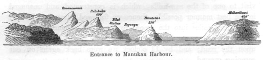
January 20. The house was built by the Government as the station of the pilot for Manukau Harbour. It stands upon a rock 300 feet high, shelving off towards the sea so abruptly, that the passage down to the landing, at the time of my visit, when the projected stairs were not yet existing, was a really break-neck affair. The building material for its structure and furniture all had to be hauled up over the precipice by means of a crane, like up a tower. The house is splendidly furnished, and supplied with a measure of comfort, one would never expect to find in such a Robinsonian seclusion and upon a rock so inaccessible. This spot commands a wide view out to the sea. It has been asserted, that in perfectly clear weather even the snow-capped peak of the Taranaki mountain, at the entrance of Cook Strait, a distance of 140 sea-miles, is visible. From the signal station erected upon the opposite conical rock Paratutai (350 feet high), the signals are given to vessels arriving, for the purpose of guiding them safely through the channels between the dangerous sand-banks in front of the entrance.
After breakfast we climbed down the steep rock to the beach, and walked along the coast northward. The land shelves abruptly towards the sea over barren walls of rock, 400 to 500 feet high, along which mighty banks of rough, volcanic conglomerates and breccias, broken through by basaltic dykes, are laid bare. But a broad, flat sand-beach, upon which the waves roll sluggishly, and a row of sand-hills still separate the foot of that stonewall from
[Image of page 265]
the sea. Similar to this is the character of the coast on the whole West-side of the North Island, so that the sandy beach, for want of other convenient passages, is the natural road for the communication along the coast. It is only at a few projecting points, that the surge breaks directly against the rocks, which must then be climbed over, sometimes not without danger.
The whole sea-beach from Kaipara Harbour as far as Taranaki South, a distance of about 180 sea-miles, consists of fine sand abounding with titaniferous magnetic iron; and at places where wind and waves have distinctly separated the heavy black iron-sand from the lighter grains of quartz, the beach presents an appearance as if gunpowder had been spilled there. Already the earliest settlers on the Taranaki coast directed their attention to this peculiar black sand, which is strongly attracted by loadstone, like iron filings. Samples of it were repeatedly sent to England, and there submitted to chemical analysis. It was found that 100 parts contained 88.45 parts of black oxide of iron and 11.43 parts of oxide of titanium, a compound similar to the iron-sand of volcanic districts. An analysis by Mr. Moritz Freitag has yielded, protoxide of iron 27.53, sesquioxide of iron 66.12, oxide of titanium 6.17. For years past, therefore, it has been an object of speculation, to apply this iron-ore to technical purposes; and within the last years experiments have been made on a larger scale. The merit in this affair belongs to Captain Morshead, who went to New Zealand and brought several tons of the ore back to England for decisive experiments. These trials are said to have led to the most satisfactory results. The sand yields 61 per cent of iron, and steel of unusual hardness and tenacity can be produced from it. Messrs. Mosely in London have submitted the Taranaki-iron and titanium-steel to tests, and declare them to be of most superior quality. Should it be confirmed as a matter of fact, that the Taranaki steel surpasses by far all other sorts of steel in quality, we may well take it for granted, that the Taranaki iron-sand will prove of great value, if it is only possible to obtain large quantities of it sufficiently pure to be smelted, a thing I have reason to doubt.
[Image of page 266]
Behind the sandy beach, basins of fresh-water are frequently found, and at the foot of the rocks deep caverns are seen washed out, in the background of which generally large masses of boulders are deposited. This would indicate a former period, when the surge washed the rocks themselves, and piled up those masses. Now, these caves are a safe camping-place at night for the cattle grazing upon the grass-covered sand-hills.
January 21. All night the storm was raging round the house, and when at break of day I looked from our lofty watch-tower over the mountains and the sea rolling beneath, it did not appear as though we should be able to undertake anything at all on that day. A violent N.E. wind chased heavy clouds from the sea upon the land; and the sand-banks at the entrance of the harbour, which during spring-tide or a calm sea are scarcely visible, were to-day plainly to be seen amid the wildly breaking surges. Towards 9 o'clock, however, the wind veered more to the West, and subsided; and we had after all a fine, clear day. We sailed across the strait to the South Head, the Mahanihani of the natives. What a remarkable difference between the two shores -- North Head and South Head! On the North-side, ranges densely covered with forests, sharp pointed conical rocks, hard masses created to bid defiance for thousands of years to the impetuously dashing waves; upon the South-side nothing but loose sand, whirled up by the sporting winds to a height of 500 feet against the barren steep, which in some places free from sand presented only soft strata of clay and sandstone together with thin layers of lignite. This contrast in the composition of the two shores proves, that the entrance to Manukau Harbour owes its origin to a considerable dislocation in the coast-range.
Thence we rowed along the southern shore of the Manukau, and arrived in the afternoon close to Kauri Point at Mr. Graham's dwelling, where Mrs. Graham, in the absence of her husband, gave us a most hospitable welcome. As Captain Wing, in compliance with the duties of his office, was obliged to return to his station, our luggage was here put ashore. We were all under great obli-
[Image of page 267]
gations to the gallant captain for his valuable company and for the hospitable reception at his house.
The point we had now reached, offered very little for attraction. The steep declivity of the shore, about 100 feet high, as far as I had followed it up, presented, in unchanging monotony, clayey or sandy banks, alternating with strata of bituminous shales and lignite. The only remarkable feature of this spot is the presence of a thick bank of reddish-brown sandstone containing magnetic iron, the same as on the peninsula of Puponga. This bank can be traced along the whole South-side of the Manukau Basin. As to the rest, the region, almost treeless and little fertile as it is, presents a desolate and cheerless aspect, and I could well appreciate the complaints of good Mrs. G., who -- after many sad blows of adversity, and after having finally, in Bass Strait between Australia and Van Diemensland, by a shipwreck lost all she had, saving nothing but the bare life -- when cast upon this shore, was longing to exchange this dreary solitude for more genial regions. She exerted herself to the utmost of her efforts, to render the evening as pleasant as possible to her guests, and after we had retired, she even made her music-box play soft melodies to lull us into gentle repose.
January 22. The question, how from Kauri Point we were to reach Waiuku, a distance of about 18 miles by water, was most satisfactorily solved by a lucky accident. A small schooner of 20 tons, the "Sea Belle," which was plying between Onehunga and Waiuku, for the purpose of bringing from the latter place the produce of the natives, flour and flax, to the market of Onehunga, ran on her trip to Waiuku in the morning close to Kauri Point and took us on board. True; we had to confide ourselves to a vessel that was in a most miserable plight, and the master of which calculated besides upon the passengers performing sailor duties; for while the so-called captain sat continually at the pump, engaged in pumping out the water as it came streaming into the leaky boat, and while his only helpmate managed the helm, the weighing of the anchors and the setting of sails was left to the passengers. Meanwhile the
[Image of page 268]
wind was favourable; by 11 o'clock already we had reached our place of destination, and the "Sea Belle" lay before Waiuku; not, however, as one might suppose, at anchor, but, as the captain had deemed it the far simpler way of disposing of her, fast aground in the mud. There she is lying perhaps up to this day, rotten and decayed.
Waiuku, -- the word is a compound of wai, water, and uku, white clay, -- is a very appropriate name for the place. It is the name of the creek, which, in a southerly direction from Manukau Basin cuts deeply into the land; and the low banks of whose shores are formed of white clay and sand, below which, just at the water's edge, layers of peat-like lignite, in a thickness of several feet, crop out. These are the same post-tertiary strata, which reappear farther to the North West in the creeks at Drury and Papakura, and which compose the extensive flats on the East and South-side of the Manukau. Where the white clay forms the surface, there the land is sadly sterile. Luckily, however, the clay is covered to a large extent by basaltic conglomerate, the gradual decomposition of which furnishes a fertile, arable earth.
At the South-end of Waiuku Creek a cluster of houses, among which several mercantile shops and two taverns, presents the first start of the town of Waiuku; William's Hotel formed our headquarters. Though its environs can boast only few points of attraction, yet, the site of the place is an interesting one, lying as it does on the great thoroughfare of the natives from North to South, upon a kind of isthmus, which separates the Manukau Basin from the largest navigable river of the North Island, the Waikato. Between the upper end of Waiuku Creek, and Awaroa Creek 4 emptying into the Waikato River, there intervenes only a flat ridge l 1/2 miles wide, and not above 40 to 50 feet high, over which a brisk trade is continually carried on; because upon this road the natives bring their produces from the fertile Waikato valley, the granary of the North Island, to Manukau Harbour. It has, therefore, also been
[Image of page 269]
considered profitable to have a canal dug for the purpose of connecting in a direct line the most important water route of the country with a harbour in the immediate neighbourhood of Auckland.
A walk from Waiuku to Purapura brought us to the camping-place of the natives on Awaroa Creek. There we met a large company, that had embarked upon a trading trip to Onehunga, and had just arrived from Waikato. It was really an interesting scene. The men, large, robust figures, with grave faces beautifully tattooed, were cozily smoking their pipes, while the women were busy peeling potatoes with the sharp-edged shells of the common Waikato Unio (Unio Aucklandicus), and preparing their social repast. But as on such journeys nothing is left behind, there was also no lack of children, dogs and pigs playing about in unrestrained companionship. The provisions, which the natives carried with them, consisted of large quantities of dried Waikato-eel, and baskets of peaches, apples and potatoes. The articles for the market were flour, flax and Kauri-gum. We received a cordial invitation to partake of their meal, but contented ourselves with conversing with them instead. They were extremely talkative, and, like all Maoris, curious to learn our names and the object of our expedition. My name caused them no small difficulty, and it was really amusing to observe them, as they endeavoured to pronounce it in the most different manner, until at last one of them seemed to have found its true version. He called me Hokitata, and from the pleasure and satisfaction shown at it by all the rest, I could easily infer, that by it he had found the right word with the right meaning. My friend Purchas had previously informed them, that I had come from afar for the purpose of seeing their country, and that I was about to return soon. Then, of course, I could have no name more significant than Hokitata, literally meaning "about to return soon." This name, then, remained henceforth as my Maori-name upon all "my excursions through New Zealand, with the single variation of Hokiteta in some districts, and the addition of Te Rata, the doctor.
Sometime afterwards, the whole company passed through
[Image of page 270]
Waiuku. Men, women and children were pulling all together a large canoe, which they were dragging from Awaroa Creek to the Manukau; and one of them, in a red shirt, with a battle-axe (mere) in his hand, skipping about with the quaintest gesticulations, and singing and dancing, led the noisy procession.
January 23. -- Sabbath day. -- Waiuku at present belongs to the diocese of Onehunga, and having no pastor of its own, Rev. Mr. Purchas performed divine service to-day. To me the day of rest was a welcome one, as it gave me sufficient leisure to arrange my collections and to work at the map of the district. The evening we spent very pleasantly with the amiable family of Mr. Griffith. The pretty collections of beetles and plants made by the members of the family convinced me anew of the lively interest, taken by the colonists in everything that has reference to the natural history of New Zealand. The same observation I had afterwards occasion to make wherever I visited any one. Nearly in every house, in every family, I became acquainted with, there was somebody making collections. Here it was the husband, who had a collection of insects; there the wife, who pressed mosses and fern-leaves neatly between paper; or the sons and daughters, that gathered shells and seaweeds; and from their treasures I was always certain to have some new specimen or other, which I had hitherto not possessed, presented to me with a hearty welcome.
January 24. A most delightful morning. The fresh Southwestern breeze, in these parts always the harbinger of pleasant weather, had swept every cloud from the sky. After some fruitless endeavours to induce the natives to transport our luggage in their canoes to Waikato, upon paying them any reasonable demand, we found ourselves compelled to leave whatever we could possibly dispense with, behind at Waiuku, and, taking with us only the most necessary articles, to continue our journey to the mouth of the Waikato River. Mrs. Jenkins, to whose kindness I am indebted also for some fine specimens of Helix Busbyii, had furnished us with horses, which for the distance we had to go, were of great service to us.
[Image of page 271]
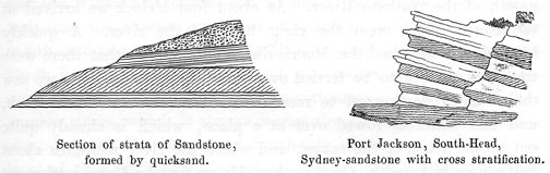
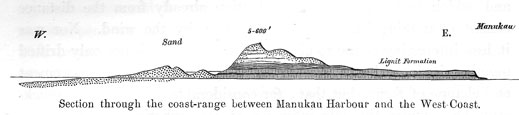
We turned westward towards the sea-coast. Two miles from Waiuku we passed the small Maori village Tauwhare. Thence the road rises gradually to the height of the hills forming, 6 to 700 feet high, the coast-range. The higher the traveller ascends, the more his passage is obstructed by quicksand, till on the top he finds himself in a perfect desert of sand. I was not a little surprised to find, that the conical summits of the hills ascending steeply, sometimes at an angle of 45 degrees, and ending in sharp points, which here and there are seen to spring up from the ridge, and which had attracted my attention already from the distance consist of nothing but quicksand piled up by the wind. Nor was it less interesting to me to observe, how the sand is not only drifted together in loose heaps, which are subject to continual movement and change of form, but that, for considerable distances, the quicksand has, under the sole influence of atmospheric currents, deposited itself in regular strata almost in the same manner, as the drift-sand of creeks and rivers. According to the respective course of the wind and the surface of deposition, these strata assume, different directions, and there are sections to be seen, where there
are quicksand-banks with a double stratification. They reminded me vividly of the cross stratification, such as the ancient palaeozoic sandstone-banks at the Heads of Port Jackson near Sydney present them, the larger strata of which are composed of a number of minor layers placed obliquely to the general planes of stratification. While through the influence of rain and the atmospheric agents in general, a gradual decomposition of the magnetic iron, contained in the sand, into brown iron-ore (hydrated oxide of iron)
[Image of page 272]
is produced, the layers of quicksand are gradually consolidated into an iron-coloured sandstone, which differs from the sandstone deposited from water only in this, that in the former there are animal and vegetable remains from both the land and the sea promiscuously embedded in it; a circumstance, which, for the correct interpretation of a great many remarkable facts in older sandstone formations, is decidedly worthy of notice. In this manner, a large portion of the sandstone strata composing the coast-range between the Manukau and the Waikato, seems to have been formed.
Passing through a small valley, we arrived by a rapidly descending path to a place on the coast, called Rukuwai after some sandstone-cliffs, and hastened close by the white foaming surge upon a sand-beach strewn with shells, in full speed towards the mouth of the Waikato River. At about four o'clock we arrived at the North Head upon the right bank of the river. A quickly kindled fire informed the Maoris dwelling opposite, that there were travellers waiting to be ferried over; and, indeed, ere long we saw their canoes starting off to receive us. We sent our horses back, and had ourselves rowed over at a place, which is already quite out of the reach of the surge, and where the river measures about half a mile in breadth. On the other side we found a Maori settlement Maraetai, (i. e. near the salt-water), consisting of 7 or 8 huts, and but a short distance from it, at the foot of a wood-clad ridge, at the edge of a little dell, stands the house of the Rev Mr. Maunsell, a deserted missionary station. Since Mr. Maunsell has moved farther up the river to Kohanga, the house has been utterly neglected, and seems to be but rarely inhabited. We, however, happened to find one of the missionary's sons there, and made ourselves as comfortable as possible in the scantily furnished dwelling.
[Image of page 273]
After a short rest we started off for the purpose of inspecting the mouth of the river. Despite a breadth of half a mile at its mouth, the Waikato does not succeed in making the same grand and imposing impression here as farther up, where it flows between green, wood-clad mountains, and around islands with a most luxuriant vegetation. The mouth is dammed up by a sand-bar, over which the sea is continually breaking heavily. Only during a perfect calm is it advisable and practicable for little boats to venture out and back again. Inside the bar the depth of the water is as much as five and six fathoms. The tide comes and goes with a velocity of 4 miles, and makes itself felt to within 10 or 12 miles up the river. It is remarkable, that at the mouth of the Waikato there is not an estuary similar to that of the Manukau, Kaipara, and Hokianga in the North; or as at Waingaroa, Aotea and Kawhia in the South. With regard to this point I have repeatedly heard the opinion expressed, that the Waikato River had formerly emptied into the Manukau Gulf, and that its present mouth is comparatively of recent date. Yet, I cannot corroborate this opinion; I believe myself right in assuming, that the Waikato River also had in former periods a similar estuary, and that the extensive swamps, beginning two miles above the mouth, and now partly covered with bush, through which the Awaroa Creek is meandering, are parts of that former estuary, which the river has gradually almost filled up with masses of sand, mud, and pumice stone, which it always carries along. The bed of the river also, between the North and South-side of the mouth, has in the lapse of time changed its course in consequence of alluvial deposits and quicksand. At present, the river channel is situated on the North-side, which, being almost entirely destitute of vegetation, presents the dreary aspect of sand-hills rising successively higher and higher, one behind the other, the gray colour of which is interrupted only by accumulations of shells. On the western corner of North Head the surge is continually washing out sea-shells, on the opposite side fresh-water shells from the Waikato. The quicksand extends to a great distance both up the river and inland.
[Image of page 274]
Where nothing is to be seen now but a sandy desert, there, it is said, stood generations ago a Maori village with luxuriant Kumara plantations. The natives tell of an extraordinarily high tide, and of a violent hurricane, that have wrought such changes, and turned the river from its bed. Up to this day, a broad alluvial plain, strewn with fragments of pumice stone, and a lagoon in the middle thereof, called Totomoaku, a favourite resort of wild ducks, indicate the river-bed of old at the foot of the steep, rocky South Head.
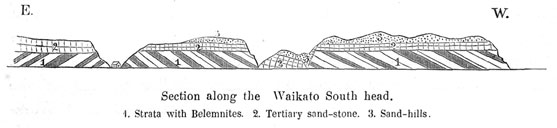
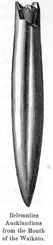
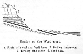
To the geologist, the South Head is a locality of considerable interest. Where the sand-hills cease, there a steep, rocky coast commences, extending towards Okariha Point, and washed by the surge at high tide. At neap tide, a narrow strip of sand-beach is laid dry, which presents a convenient path nearly as far as Okariha Point. The rocks consist of marl and sandstone, the strata being piled one above the other with extraordinary regularity like the leaves of a book, and dipping to the West at an angle of 35 degrees. The sandy strata contain indistinct fossil plants and particles of coal; the marls are streaked with white veins of calcareous spar, and interspersed with iron pyrites. It was here, that I discovered the first Belemnites upon New Zealand. Those Belemnites are found of various sizes; the largest being finger's length and finger's thickness. They are all distinguished by a deep furrow, and are excellent representatives of the family of Canaliculati (d'Orbigny). 5 Besides Belemnites there are found in the same strata Aucella plicata, Zitt., Placunopsis striatula, Zitt., and other small Bivalves.
[Image of page 275]
I consider that complex of strata to correspond to the Lower Green-sand or to the Neocomian of the French. Unconformably above the inclined Belemnite-strata are deposited horizontal banks of a whitish-yellow, very finely granulated sandstone of the tertiary age, containing a great number of fossils such as: Brissus eximus, Zitt., Schizaster rotundatus, Zitt., Cidaris sp., Waldheimia lenticularis, Desh., Terebratulina sp., Pecten poly-morphoides, Zitt., and sharks-teeth. 6 I recommend this locality, so abounding in fossils, to future collectors, who will find here yet a good many curiosities, which have escaped my notice in consequence of my short allowance of time.
January 25. Already in Auckland I had heard of the existence of coal on the West-coast, about seven miles South of the mouth of the Waikato, and I therefore set out to-day for the purpose of inspecting the designated spot. I followed the "Queen's Road" a much trodden foot-path leading from the Waikato along the West-coast to Taranaki, along which a native carries every fortnight the mail from Auckland to Taranaki. The way leads from the Mission station over meadows and fern-hills to the heights of the coast-plateau, about 700 feet above the level of the sea. From the height reached first, a beautiful view opens northwards over the coast-region between the Waikato and Manukau. The mail-steamer was just puffing in front of the entrance to the harbour; but, this excepted, there was no other sail in sight upon the blue sea, which in long, double and triple, white foaming lines of breakers is bordered by the rows of sand-hills at the coast. The road continues over hills, at times through ferns, at times through tracts of bush which extend from the valleys up to the heights. Upon a point, called Mahunga, an unobstructed prospect opens suddenly
[Image of page 276]
towards South. I stood as if spellbound. The sky was cloudless, the atmosphere so transparent and clear, that whatever rose above the horizon, was plainly visible. Before me rose, emerging from the blue ocean, the old volcanic cone Karioi, 2370 feet high, the huge corner-pillar at the South-side of the entrance to Whaingaroa Harbour, from its foot to its top densely covered with forest; farther to the interior, in the blue distance, the trachytic Mountain Pirongia, situated on the Waipa River; farther to the South, Albatross Point on the South-side of Kawhia Harbour; then at a still greater distance faint outlines of land extending far to the West; and farther yet to the West upon the blue sea I descried a gigantic cone with snow-clad summit. This was Mount Egmont, the famous Taranaki Mountain. I experienced an indescribable joy, at beholding, for the first time, that magnificent volcanic cone; although at a distance of not less than 116 sea-miles, yet so distinct, that I could plainly discern the regular ribs, running down its slope; and even now, in the middle of summer, its summit was still to a great extent covered with snow.
Farther ahead we met by the road-side some few huts, surrounded by luxuriant bushes of the flax-plant. The native, who accompanied us, whose name was Kuki, i. e. Cook, explained to me, that this was a Maori-camp, and that the huts had been erected for the purpose of providing a shelter for travelling parties. One of the Phormium bushes was tied together. This excited the attention of our Kuki; he untied the bush, scanned the leaves singly, and broke out into a loud laugh of joy. On going up to him, I saw that the leaves had all been written on. Kuki explained to me, that they bore the names of his friends and acquaintances in Whaingaroa, who had but lately passed that way, and that upon a second leaf a young Maori had traced a fond greeting to his beloved. Kuki now likewise cut his name upon it with a muscle-shell:
Na Kuki
91 + 75 + 73 7
[Image of page 277]
and very carefully tied the bush up again. Having once had my attention directed to this peculiar Maori custom, I found similarly inscribed Phormium bushes in the most different parts of the country. We might be inclined to laugh at this harmless folly of the Maoris; but in fact, in Europe such folly is carried out to a still greater extent, by cutting names or initials into the bark of trees, and by scribbling on ruins, rocks, caves and the like, with the idea of immortalizing oneself.
Soon afterwards we met the mail-carrier on his way from Taranaki to Auckland. He was a robust Maori, who carried the mail-bag, bearing the royal seal, upon his back; a glowing slow-match in one hand, and a powerful stick (turupou) in the other. Upon my asking for what purpose he carried the heavy stick, he replied defiantly, "to defend himself against Pakehas," and passed on. After a walk of three hours we descended to the beach; and proceeding along the strand in a southerly direction two or three miles farther, we soon arrived at the locality previously pointed out to us.
While the strand consists of fine magnetic iron-sand, the higher rocky coast-banks present instructive sections. The deepest layers visible, consist of greenish-gray conglomerate and sandstone. In it are embedded a great many short, but thick, logs entirely silicified. In other places chunks are found with their bark turned to coal, thin layers of bituminous shale, and small coal-seams. These coal-seams lie just at the high-water line with an inclination of 10 to 15 degrees westward to the sea; and at several points the heads of the strata are seen to rise above the sand of
[Image of page 278]
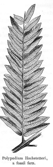
the beach. The coal is a fine glossy coal with conchoidal fracture; different from the brown coal at Drury, and already resembling rather a black coal. The piece which I knocked off of one of the strata emerging from the sand, is lined in two directions, perpendicular to one another, with leaves of calcareous spar, as thin as paper, and is thereby divided into a number of small dice one or two lines in thickness. The layers, however, measuring only a few inches, are not thick enough to be of any practical importance. Above the coal bearing strata there lie gray marl-banks containing many very remarkable fossil plants. Unfortunately, the banks at the surface are so much broken and crumbled, that, for want of the necessary instruments for digging deeper, I only succeeded in collecting a few distinct pieces with very neat fossil ferns, which have been named Asplenium palaeopteris by Prof. Unger. The topmost beds consist of tabular limestone, replete with foraminiferae and bryozoes, which towards the top change to banks of a finely granulated, yellowish-white sandstone, which breaks in large squares and reminds one of the Quader-sandstone of Saxony or Bohemia; but which, from the fossils enclosed, we infer belongs to the tertiary formation.
A similar section may be observed at a point lying but a few paces north of the spot, where we had reached the beach. Passing northwards along the beach, one has to climb over large sandstone and limestone blocks, and then arrives at a vertical bluff, against which the surge beats, and beyond which it is impossible to proceed. Amongst the rocky masses scattered here at the foot of the bluff, large blocks of calcareous marl of greenish-gray appearance are found; by breaking them with a hammer, a rich collection of the most beautiful specimens of fossil ferns may be easily obtained. Like those at the previous locality, however, these also belong to only one species, but differing from the former and not corresponding to any of the species now living upon New Zealand. Prof. Unger has named it Polypodium Hochstetteri. This locality, as well as that of the Belemnites on the Waikato, was formerly not known at all. Our Kuki was utterly lost in astonish-
[Image of page 279]
ment, when he saw, that ferns, "trakau," were growing not only in the woods, but also in the rocks of New Zealand. Besides the load I had given him to carry, he put another extra-piece into his pocket, which he showed to every native we met, every time exciting by it no small degree of surprise.
Heavily laden with the treasures found, and quite satisfied with the results of the day, but at the same time also very tired and hungry, we arrived at sunset again at our quarters on the Waikato. But here, what a disappointment? The little pig, which we had bought in the morning, to have it roasted for supper, had escaped from the old hag of a Maori-woman, -- who had offered to attend our cooking, -- into the woods; and for the day there was nothing left us, but the scanty remnant of a ham, which we had brought with us from Waiuku.
January 26. -- Our provisions had gone out, so we resolved to return to Waiuku, choosing the water-route on our way back.
For a compensation of 15 shillings the natives agreed to convey us in a canoe to Awaroa Creek. Thus we passed up the Waikato, along the sand-hills of the right bank. Two miles above Maraetai the river grows very broad, and contains many marshy islands covered with raupo (Typha angustifolia). The left river-bank with its fields of luxuriant growth presents a lovely aspect, and the white church-steeple of the missionary station Kohanga glistened from afar a friendly welcome.
After a trip of one and a half hours, partly upon the open river, partly between the river-islands, we turned off into the Awaroa Creek, the military road of yore and now the modern commercial road of the natives. We had the tide with us, and the
[Image of page 280]
passage up the narrow bush-creek, which is just wide enough for two canoes to pass each other, would have been one of the most agreeable, but for the millions of blood-thirsty mosquitoes, which almost drove us to despair. We were therefore glad, when, on our emerging from the swampy bush into the more open grassland, that plague abated in some measure. But the channel became now so shallow, that the native had to get out, in order to lighten the canoe. A rope having then been made from phormium-leaves tied together, the canoe was tugged along by this means, until we reached the landing-place at Waiuku.
January 27. -- From Waiuku we set out to Mauku, 8 and found hospitable quarters at Major Speedy's, a late officer of the Bengal-army, who now has settled down as farmer in New Zealand.
"By the banks of the Mauku we've fixed our abode,
Where its serpentine current runs down to the sea,
Through the bush and the fern we've opened a road,
And made up our minds to live happy and free.
The world's cares and pleasures are easily seen
To be fitful and vain as the foam of the sea;
We care not for either, -- our minds are serene --
By the banks of the Mauku we're happy and free."
Thus sing the merry settlers of Mauku, the happy neighbours of Waiuku. Let him who intends writing novels about the farmer life of the colonists of Now Zealand, take up his quarters here; let him make himself at home in the farmhouses of the Mauku-district, so abundantly blessed with rosy daughters, and he will never want matter to suit his purpose. There live the Speedy's, the Vickers, the Crispes, and whatever the names are of all the amiable families in that neighbourhood. Quite romantic is the situation of their snug and comfortable country-seats at the edge of the bush. Bush alternates with meadows, gardens and fields, waving their rich, luxuriant growth upon fertile basaltic ground.
[Image of page 281]
Upon the heights charming views open to the Manukau Gulf and as far as the volcanic cones on the Isthmus of Auckland. In the valley there are fresh brooks, which, as they plunge headlong over columnar rocks of basalt, form cascades bordered most beautifully with the richest vegetation of New Zealand ferns. And whoever happens to be as lucky as we, will be accompanied thro' woods and fields by pretty young maidens, the choicest flowers of Mauku, mounted on their fleet steeds; and when he takes leave, a blue-gumtree will be planted for him in remembrance of the days and hours spent in idyllic bliss and merriment.
From Mauku a speedy, but rather fatiguing ride across uniform fern-land brought us on January 28. to Drury, and thence we returned by the Great South Road to Auckland.