CHAPTER XVI: From the Waipa through the Mokau and Tuhua districts to Lake Taupo.
[Image of page 333]
CHAPTER XVI.
From the Waipa through the Mokau and Tuhua districts to Lake Taupo.
On the upper Waipa. -- Terrace-formation. -- Orahiri. -- Hangatiki. -- Caves with Moa-bones. -- The stalactite-cave Te ana Uriuri. -- Sabbath breaking punished. -- Mangawhitikau. -- Limestone plateau with caves, subterraneous river passages, and funnel-shaped holes. -- Puke Aruhe. -- Stay at Piopio; rubbing of noses. -- Moa-bones. -- Wairere rapids. -- Pukewhau. -- The Mokau river. -- Bush and swamp. -- A wood-colony. -- Maori cooking-stove. -- Tapuiwahine mountain. -- In the Ohura and Ongaruhe valley. -- On the summit of the Ngariha. -- View of Tongariro and Ruapahu. -- A Tangi in Petania. -- Puketapu. -- Nothing but bush. -- Pumice-stone plateau Moerangi. -- Arrival at Lake Taupo.
To reach lake Taupo from the Waipa, I had the choice of two roads. The one, via Otawhao, past the foot of the Managatautari, along the Waikato valley reaches lake Taupo at its Northend. This is the road taken by Dieffenbach in 1841, and over which the mail is now carried every fortnight by Maoris from Ahuriri on the East Coast to Auckland. The second road leads up the Waipa through the upper Mokau and Wanganui country to the Southend of the lake. This is longer and much rougher than the former; as it leads, however, through rarely frequented districts, it promised many interesting items. I was the less reluctant to decide upon, the second route, because I hoped to succeed in gathering there some moa-bones; and consequently I fixed upon the 1st of April as the day for continuing our journey.
Thus with a new month also a new chapter of our journey opened. Up to the present we had after a few days' journey re-
[Image of page 334]
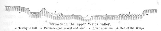
peatedly found hospitable quarters in European houses, with settlers or missionaries; but now the European settlements ceased and we had to travel to lake Taupo through a country exclusively, and for long distances but thinly, populated by natives. My guides representing to me that the road was very difficult to travel, that it lay through numerous swamps and woods, up and down steep mountains, rendering the transportation of the heavy photographic chests impracticable, I proposed to Mr. Hamel, to travel direct to Lake Rotorua, thence to Lake Tarawera, and to meet us again at the latter place after having taken views of the most interesting points. Thus we parted: Mr. Hamel, accompanied by four natives, set out in the direction of Otawhao; my route lay in a southerly direction up the Waipa, and after the departure of the photographic company, my party numbered only eighteen. My servant James, whom I had been obliged to leave behind sick at Mr. Read's, I had supplanted by a robust young fellow, named Harry Turner, -- a first rate specimen of the Maori-European mixed race, who would have been an honour to any grenadier-regiment in Europe. We took a hearty leave of Mr. Read and his family, and when upon starting we waved, after German manner, a final, cordial farewell to the amiable ladies of the house, one of the Maoris said: "now look, these gentlemen are real European chiefs; they have manners, indeed; the others are only slaves." My knee still smarting considerably, and the nature of the ground admitting of riding on horse-back, I had made use of the kind offer of Mr. Read, who lent me one of his horses. Not far from the missionary station we had to cross the Waipa; the water in the river was so low, that I could easily ford it, my companions crossing in canoes. Our road lead thence along the right (East) bank up the river. The landscape on both banks of the river attracts attention by the extreme regularity of the terrace formation, presenting itself in three successive levels. In its sinuous course the river intersects a broad alluvial plain, rising from 12 to 15 feet above its bed. A steep bluff, 20 to 30 feet high, leads from this first terrace on to a second extremely fertile, and well cultivated plain;
[Image of page 335]
and another bluff, 80 to 100 feet high, leads to an extensive table-land consisting of trachytic tuffs, above which wood-clad ridges arise, and at a greater distance a number of extinct volcanic cones, such as the Puketarata, the Taurangakoho and others. From the terraces every vestige of the primitive forests has long disappeared; only isolated Ti-trees, Phormium-bushes, here and there groups of Kahikatea-pines, and the settlements of the natives, interrupt the broad, monotonous fern-covered plains.
The first small settlement we came to, about five miles from Read's, is called Awatoitoi, it consisted of six scanty huts. One mile farther up on the left bank is Tuahu. Another mile farther the Waipa receives the Mangaoronga, a considerable tributary from the right. Upon the peninsula formed by the confluence of the two rivers towers the ancient Maori-castle Tohorewa with steep cliffs, 60 to 80 feet high. The rugged rocks, upon which in olden times a pah stood, consist of a compact trachytic tuff containing pumice-stone. Large blocks of it are scattered around. Having crossed the Mangaoronga, we passed along the foot of the old pah on to the height of the table-land, which the natives here call Kareauwaha. There is a beautiful prospect far over the broad valley of the Waipa with its terraces and native settlements. On the right bank of the river is Kourapirau, meaning a place, where craw-fish cease to be found. The scattered huts farther up belong to Mohoanui and Orahiri. By an isolated conical rock, named Haereuku, our path turned towards the river. We crossed it at a place very shallow in consequence of sand and gravel-banks, and pitched our tents on the left bank, near Orahiri.
Orahiri is one of the chief points on the Upper Waipa. Having received two considerable tributaries from the left, the Mangapu 1
[Image of page 336]
and the Mangawhero, the river takes a south-easterly direction towards the Rangitoto-range. The valley here changes to an extensive plain covered with Kahikatea-forests; in the background rises the wood-clad Rangitoto-range forming the water-shed between the Waipa on one hand, and the Mokau and Wanganui rivers on the other. The river-pebbles lead us to suppose, that the Rangitoto-range consists of shale, sandstone and marl, and consequently is not of a volcanic origin.
April 2. -- In the morning the mountains were shrouded in dense fogs, which vanished towards noon. The sky, however, remained veiled all day, so that the sun could scarcely peep through. It was not until sun-set, that the misty veil arranged itself in chains or streaks of fleecy cloudlets, all shooting from Northwest, and lit up by the magnificent red and yellow lustre of the parting sun, thus imparting to the sky a quite peculiar appearance, and promising a bright and clear morning.
We set out from Orahiri at 8 o'clock. The little Orahiri creek is dammed up, and forms a mill-pond which abounds in eel. Our road lay across the dam. Here we left the Waipa valley, and turning in a south-westerly direction to the heights on the left bank of the Mangapu, we reached the Mangapu valley itself about six miles from Orahiri, near the Maori village Hangatiki. Here the Mangapu receives the Mangaokewa from the right. The steep ridge between the two rivers, at the foot of which the church of Hangatiki stands, is called Pukeroa. The inhabitants of the settlement belong to the Ngatihuiau-tribe, and have the reputation of having acquired to perfection all the tricks and wiles of European peddling Jews. Yet, they very kindly brought me some grapes, the first I saw and tasted in New Zealand; I found them, however, very sour.
The landscape here assumes a new character. From the broad, open valleys of the upper Waipa, the traveller, in passing up the Mangapu, gradually enters the mountains and hills bordering the plains of the Waipa and Waikato to the South and Southwest. Hangatiki is situated just at the foot of the higher table-land which,
[Image of page 337]
though its surface appears very much cut up and broken, nevertheless presents a very simple geological structure. The lower beds, appearing in the valleys, consist of stratified limestones of the same description as those, with which we became acquainted on the West coast (Whaingaroa, Aotea, Kawhia), and above them lie thick beds of trachytic tuff. The limestone abounds in caves; the volcanic tuff on the other hand forms compact banks resembling sandstone, with the white fragments of pumice-stone looking from afar like fossil shells.
At Hangatiki I heard of three caves in that vicinity. Te ana o te moa (moa-cave), Te ana o te atua (ghost-cave), and Te ana uriuri (dark cave). The moa-cave is about one and a half miles Southwest of the kainga Parianiwaniwa, which is about five miles from Hangatiki in the direction of W. 24 deg. S. The ghost-cave lies at the road to Raraoraro, a distance of one mile from the Maori settlement Rotomarama. Both caves abound in stalactite formations. They had been repeatedly visited by English officers: the last time, in October 1852, by Dr. A. Thomson, Major Hume, and Captain Cooper, who went there in search of moa-bones. Those researches have according to Dr. Thomson's account 2 led to very satisfactory results. Numerous bones were dug out. The natives assuring me, that there was nothing more to be found, I resolved to visit only the third cave, Te ana uriuri, it being less out of my way. This cave lies four miles from Hangatiki on the road to Pukemapau and Paripari. Its entrance is 24 feet wide and 20 feet high. It is situated at the northern foot of a hill composed of tabular limestone, the slope of which was overgrown with bushes of the New Zealand coffee-shrub, -- Karamu of the natives (Coprosma lucida Forst.), -- full of red berries. The limestone formation attains here a thickness of at least 200 feet. Just at the entrance beautiful stalactite formations are to be seen, grown over most picturesquely with ferns as far as daylight peers into the cave, presenting thus the appearance of an artificial decoration. To the right a stalagmite-pillar, 7 feet high, spreading its top like a table, and
[Image of page 338]
overgrown with the most beautiful ferns looks like a real flower-table; and on the left an equally decorated stalactite represents a flower-vase suspended from the ceiling. Thirty yards from the portal there is a precipice 20 feet deep, down which, however, it was possible to climb. Below, there is a water-pool with a temperature of 55 deg. Fahr. The vault of the apartment, about 40 feet high, is decorated by stalactites. Beyond the water-pool, a narrow passage leads farther into the interior of the cave. Owing to the scantiness of our illuminating apparatus, however, we were unable to proceed very far; and we moreover greatly regretted our not finding a single vestige of moa-bones.
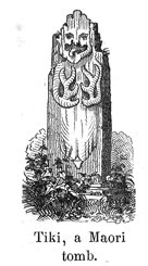
We had to return a distance of about three miles by the same way we had come; then we turned off to the village Pukahuku on the Mangaokewa Creek, and about sun-set reached a small settlement Tahuahu on the right bank of the Mangapu. Having sent my Maoris ahead by the direct road, I found our tents already pitched. An enormously corpulent woman and a Maori teacher, with a whole pack of dogs for their company, were the only inhabitants present. Beside my tent there stood an odd half decomposed figure carved of wood; it was designated to me by the natives as a Tiki, marking the tomb of a chief.
April 3. -- Sabbath-day. -- A beautiful day, indeed; as though all Nature had been created anew. Who could under such circumstances remain idle in his tent? I determined on travelling on despite the Sunday, having moreover another special reason, as our provisions were nearly exhausted, and the Maori schoolmaster at Tahuahu could not be prevailed upon by any means, to sell us some; on the contrary he deemed it his duty to lecture us on the keeping of the Ratapu. I consequently set out on my way to Mangawhitikau, a settlement five miles farther up the valley, where we arrived just at the close of the morning services. I had cherished the hope of finding the natives there less bigoted; but was sadly disappointed in my expectations. At first
[Image of page 339]
they refused the use of a canoe for crossing the river near the village; next, they would not allow us to put up our tents. After a long and tedious talking to and fro, we at last carried both points; we had, however, to put up with the disagreeable necessity of fasting for to-day, the teacher of the place forbidding most rigidly the sale of provisions. Those Maoris seemed to esteem more highly the commandments of their missionaries, than the words of their Lord and Master: "The Sabbath was made for man, and not man for the Sabbath." It was, however, the first and last time that I undertook to travel on the Sabbath-day in New Zealand.
April 4. -- It was not until to-day, that the inhabitants of Mangawhitikau grew more sociable and friendly. Already before break of day we had bought a fat pig from them, and were thus enabled to indemnify ourselves at breakfast for the involuntary fast day.
The Mangapu divides near the settlement into its three constituent branches. The eastern is called Mangarama, the middle Mangapu, and the western Mangawhitikau. At their confluence, situated 230 feet above the level of the sea, the valley opens to a basin, shut in all around by towering limestone-rocks. The Mangarama flows through a large swamp clothed with Kahikatea woods; the other two little streams, after a long subterraneous passage, suddenly issue from under the limestone rocks close by the village. The place, where the Mangapu issues forth, bears the characteristic name of Tenganui, long throat. The subterraneous course of the river is said to be four miles long. At a low water-level the natives, with torches (kapara), made of the resinous wood of the Rimu pine, crawl far into the underground channel for the purposes of catching craw-fish. The temperature of the water at the outlet of the river is 53 deg. Fahr. The river before its disappearing underground is said to run through a romantic, narrow gully in the limestone-range Mahihinui, by the Pah Pehiop. The course of the Mangawhitikau is similar to that described. It runs close by the Pah Nikau through the narrow, rocky ravine Huruhuru,
[Image of page 340]
80 feet deep, bridged over by a Totara-bridge; and then it disappears for a distance of one to two miles, to reappear again at Mangawhitikau.
The river bed is formed by the clayey strata underlying the limestone formation. The limestone contains the same fossils, that are found at Whaingaroa and on the Kawhia Harbour, attaining however in these parts a thickness of 300 to 400 feet. The limestone formation between the West Coast and the Upper Waipa and Mokau districts forms a plateau, rising to a height of 1000 feet above the level of the sea, remarkable for subterraneous water-courses, caves and deep funnel-shaped holes, called by the natives Tomo. 3 Some of them are filled with water, as the Rototapu (holy lake) near Mangawhitikau, which, as the natives say, was made by evil spirits for the purpose of catching men in it. In several of the caves repose the bones of generations past and gone; they are therefore held sacred, and Pakehas are not allowed to enter them. It is really astonishing to observe how minutely the Maoris know their country, and how they have named not only each plant, bird, or insect, but also nearly every place. Every single cave and cleft, every rock and every hole in these parts has a special name with some legend or other attached to it. In order to learn the names and legends, it is necessary to inquire of the older chiefs; the common man knowing but little, and the younger generation caring no longer for them. My source of information was in Mangawhitikau the Chief Reihana te Huatare, a stout man, kind-hearted, and of intelligent countenance, who, on my asking him the geography of the surrounding country, traced me a figurative map upon the ground, representing the rivers by little sticks of wood, and the mountains by small stones.
In winter, at a high water level, the Mangapu river is navigable for canoes establishing during that season an uninter-
[Image of page 341]
rupted water-route to the Waipa and Waikato, of which the natives avail themselves for commercial expeditions to Auckland. A portion of the villagers were just dragging along a large canoe, which they had hewn out in the woods, to the river, in order to ship 30 fat swine to Auckland after the setting in of the rainy season. In the afternoon I succeeded in getting off.
We had now to cross the dividing ranges between the Waipa and the Mokau districts. The road lay across the heights between the Mangapu and the Mangarama, partly through bush, partly over open fern-land. Two or three miles from Mangahawitikau we passed through the settlement Mania. The huts were deserted, fields and meadows utterly neglected; for the Maori-custom demands, that a place, where an eminent chief has died, shall remain uninhabited until the years of mourning are passed. The deceased nobleman, whom Mania was mourning for, was Huatare, Reihana's father. Stately peach-trees and the luxuriant growth of ferns thriving here in bushes to 14 feet high, indicated an extremely fertile soil. From Mania we ascended a steep slope, through a magnificent forest, full of the loveliest fern-trees, to the summit of the Puke Aruhe. There stood in olden times a celebrated Maori-fort. The only remnants left of it are deep moats and ditches, which, being most deceivingly overgrown with ferns, are very apt to prove fatal to the unsuspecting traveller; there are likewise numerous round stones such as the natives are wont to use in their mode of cooking. The height of the summit is 877 feet above the level of the sea. Thick banks of trachytic tuff forming the rounded tops of the mountains are overlying the tertiary limestone formation. From the open height we enjoyed once more a lovely retrospect as far as the Kakepuku over the parts travelled through during the past few days; and on crossing the range we entered an entirely new country.
Next we traversed a limestone country about one mile wide, and attracting special attention not only by the innumerable funnel-shaped holes (Tomo), amongst which the path winds along, but also by its peculiar vegetation, It was the first grass-plain I met
[Image of page 342]
with in New Zealand. The ferns, the usual growth of all open tracts of land, were wanting here as far as the limestone extended; while they covered with their thicket all the tuff-hills rising above the plain. At the southend of the plain, sharp rugged limestone-rocks, called Terore awairoa, form a small defile. Thence we ascended a wood-clad hill, and in the evening reached Takapau, a settlement consisting of a few deserted raupo huts.
April 5. -- During the night a heavy gale blew from Southwest with frequent gusts of rain; but towards morning it cleared off again. Descending from the height on which Takapau is situated, we came past the ancient Pah Whararipa. The rock, upon which the Maori-stronghold stood, arises with steep ascent from an extensive swampy plain; its lower part consists of tabular limestone, the top of trachytic tuff. On the Eastside, there issues from a cave the Waitoatoa, a tributary of the Mokau, whose district we had just reached. The road continuing partly through marshy river-bottoms, partly across the rugged crests of the hilly range that intervene between the several valleys, reaches the Mokau valley not far from Piopio, at the mouth of the Mangakohai.
Piopio is a small settlement consisting of only three huts. Nevertheless we found a large company of Maoris congregated there for a festival. On our approach, they came out to meet us bearing baskets full of potatoes and meat. A continuation of our journey was for the present quite out of the question, until the very last meat-basket 4 was emptied. I had to resign myself to my fate and, moreover, was obliged to rub noses with an extremely pleasant old woman, the honourable spouse of the great Mokau chief Ngature, who kindly administered to me a fat piece of pork, potatoes and apples, and invited me to seat myself by her side upon the unrolled mat, amid a group of weather-beaten faces, which without any further disguise might have appeared most creditably in the wellknown scene in Macbeth. The occasion of the
[Image of page 343]
festival was the exchange of presents with a tribe dwelling on the lower Mokau.
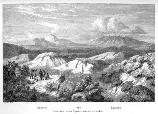
In the afternoon I ascended a height, not far from Piopio, on the right bank of the Mokau, and close by the settlement Mairoa, for the purpose of sketching and mapping the surrounding country. Opposite, on the left bank of the river, rises a wood-clad ridge, Kahuwhera; from the summit of which a beautiful view is said to be had of the Tongariro and Ruapahu. In the evening I joined the natives as they sat clustered about the fire. The topic of our conversation were the caves with moa-bones in the upper Waipa and Mokau districts. From their recitals I learned, that in former times those caves abounded in moa-remains, and that in nearly all caves of the limestone-range not only single bones were found in great quantities, but even whole skeletons; they, however, were of the opinion, that long ago every spot and track had been picked clean, and that there was nothing more to be found now. They informed me, that their forefathers already had searched those caves for moa-bones; that they employed the skulls as boxes for preserving their paint-powders; the large bones being either used as clubs or worked into fishing-hooks. Then the Pakehas came offering such enormous prices for the old bones, that the Maoris collected for sale the very last remnants. Nevertheless I do not doubt, that many such curiosities may still be found in those parts; but a great many of those caves, being used as the final resting-places of their departed ancestors, are held sacred and secret by the Maoris; moreover, it would have cost more time, persuasion and money, than I could afford, to prevail upon the natives, to conduct a Pakeha into the tombs of their ancestors, and aid him in searching for moa-bones.
April 6. -- With the rising sun the whole Maori-party had started off. Each of them had a share in the gifts, and went home with some present or other. We, too, were ready to set out earlier than usual. Our road lay through the swampy plain toward the heights bordering the valley. Here stands the village Poroporo; it was utterly deserted. At a sharp bend of the Mokau
[Image of page 344]
river, we again struck the broad plain of its valley, which displays here the singular existence of numerous, circular water-pools, poetically styled by the natives Karu-o-te-whenua, eyes of the earth. The "eyes of the earth" have a diameter of 12 to 20 feet; they are holes in the turf-moor that covers the bottom of the valley. The water stagnating therein is generally covered with a beautiful reddish liver-wort (Marshantia macropora). Mitten Thence the road slopes a second time toward the heights on the right river-bank, across a low range of picturesque limestone-rocks, 5 and strikes the river again at the grand Wairere-falls.
The Mokau, after winding in numberless curvatures, through a broad swampy valley 450 feet above the level of the sea, plunges here, foaming and roaring, over successive banks of slate into a narrow rocky gorge, a depth of about 150 feet. It is worthy of observation, that above these falls only the common eel is found, while below them other kinds of fish are met with. The water was so low, that we could without danger ford the river on a ledge of rocks just above the falls. When the water rises, the river has to be crossed in canoes at a quiet spot some distance farther up. We took a bath in the river, the water showing a temperature of 61 deg. Fahr.; and arrived about noon in the Pah Pukewhau, one mile from the left bank of the river, a charming point perched upon the wood-clad slope of the mountain.
Te Hikaka Ngatirora (vulgo Ngature), the chief of the place, received us most solemnly and ceremoniously in black attire. He seemed to be fully aware, what motives and interests had brought me into his country; for first of all he conducted me to a place, where the sight of the steaming Tongariro by the side of the snow-clad Ruapahu struck my wondering eyes. Although only the topmost peaks were visible above the dark wood-clad mountain-ridges towards the Southeast, 6 the view greatly interested me, for here I
[Image of page 345]
beheld for the first time the regular cone of the Tongariro volcanoe rising at an angle of 30 deg., and bearing the special name of Ngauruhoe; and I plainly saw the curly clouds of white steam whirling up from the crater. The natives assert, that they have never seen black smoke; that, however, the clouds of steam are often much larger, especially in winter-time. The Tongariro was clear of snow, while of the Ruapahu nothing was seen but its snow-clad summit. In perfectly clear weather Mount Taranaki, also, is said to be visible from here. We were, as yet, about 50 miles distant from those volcanic cones, and in the same direction, through sombre wood-grown mountains, lay our onward route.
But before straying off into that region of forests and swamps, we must add a few remarks concerning the Mokau river.
The Mokau is, next to the Waikato, the most important river of the West Coast, emptying into the sea without forming an estuary. Its mouth is half-way between the Kawhia Harbour and New Plymouth. Its size is equal to the Waipa. Both rivers have the same length, their course being about 80 English miles; and both have their source upon the Rangitoto range at an elevation of about 2600 feet. Thence the Waipa flows in a northerly, the Mokau in a south-westerly direction. The upper Mokau valley with its numerous smaller side-valleys spreads between ranges of wood-clad hills into wide plains, partly marshy, partly covered with grass, and very fertile.
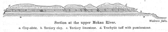
Section at the upper Mokau River.
a. Clay-slate, b. Tertiary clay. c. Tertiary limestone, d. Trachytic tuff with pumicestone.
The bottom of the valley is composed of tertiary clays, impervious to water, above which at the slope of the hills tabular limestones protrude, the heights themselves being formed of trachyte-tuff. At the Wairere falls below the tertiary clays slates of the same description as those at the Taupiri form the masses of rock, over which the river falls. Below the falls the valley becomes
[Image of page 346]
very narrow. Several miles further down, the river receives the Mokauiti, the little Mokau, its principal tributary, from the left. The latter, the course of which we shall follow on our road from Pukewhau to the Tuhua district, rises on the dividing ranges between the Mokau district and the sources of the Wanganui river. A few miles below the mouth of Mokauiti near Papatea or Whakatumu the river begins to be navigable for canoes, although numerous rapids render the passage difficult and even dangerous. From the mouth to Whakatumu up the river the natives reckon two days journeys; consequently the distance may amount to about fifty miles. The principal settlements on the river between those two points are Motukaramu, Mangatama, Mangakawhia, and immediately at the mouth the Pah Te Kauri. The old Missionary Station opposite the Pah is now deserted. Above Mangakawhia, twenty miles from the mouth of the river, along the banks seams of brown coal are said to lie open to view.
Pukewhau is a central point in the upper Mokau district. From here the roads diverge in different directions. Our destination was Lake Taupo, or, for the present, the Tuhua district towards East-South-East. The country we had to traverse presents the character of a table-land cut up by deep valleys into long and steep ranges; its height from about 1500 to 2000 feet above the level of the sea. The road lies through swamps and marshes, over hill and dale, and cannot be found without safe and expert guides. Ngature provided us with a guide to Horitu on the Mokauiti, -- a distance of three miles, -- in the person of a charming Maori girl, who led us knee-deep into swamp and mud. Here we met Te Wano, Ngature's brother, who himself became our guide thence for the next few days. In the evening we encamped on the left bank of the Mokauiti, about throe miles from Horitu, at the edge of the bush. Our camping-ground was, according to my observations, 473 feet above the level of the sea.
April 7. -- The night was cold, with a heavy dew-fall; but the day was clear, with the sun shining brightly. And, indeed, we might well congratulate ourselves, for precisely like the country,
[Image of page 347]
which we were to traverse to-day, I fancy Germany must have looked in the times of Tacitus "silvis horrida aut paludibus foeda." It was a wilderness of swamp and woods in the full sense of the word. A road or path was entirely out of the question; on the contrary, we had to work our way through, as well as we could, through deep swamps and gloomy, marshy woods.
Close to our camping-ground, we passed the Mokauiti and entered a dark, stately forest. We made a hard shift to dig our way through, over the smooth texture of roots in the sombre twilight of the virgin forest, when suddenly close by us a shot was fired, and from behind a gigantic Kahikatea-trunk a human figure stepped forth a double barrelled gun in the hand, and with a startling mien and savage gesture; in short, a brigand, such as only the most horrid brigand-story of a heated imagination could picture; and moreover, -- yonder lay the whole band encamped around a brightly blazing fire, all armed with guns. But we remembered, that we were in New Zealand; the band of brigands was after all but a peaceable Maori-party shooting pigeons. We saluted each other with a friendly "tena koutou," exchanged tobacco for some of the finest wood-pigeons, -- a capital dish for our dinner, -- and passed on. After the lapse of an hour we had to cross the creek again, and, leaving the bush, came to the deserted huts of Poporata. Thence we plodded onward for another hour along the left bank of the Mokauiti in a southerly direction, through an abominable swamp; then, for a third hour through a still worse swampy bush. If one would wish to punish criminals in New Zealand in a very severe manner, it would only be necessary to chase them up and down in such a bush, where they would sink at every step into marshy holes, tearing their legs with the knotty roots to the very bone. This punishment might be termed "running the roots." We passed the Mangawhata Creek, and about 11 o'clock reached the fern-hills, whence a view opened over the wood-clad heights we had to cross. Another hour of travelling brought us through the bush to the heights of a steep sandstone-ridge Tuparae, on the opposite slope of which we reached a clearing and a small settlement,
[Image of page 348]
called Puhanga, which I found to be 937 feet above the level of the sea.
I believe, we were not less astonished to find in that lonely wilderness a colony numbering fourteen persons, than the Maoris were, to see Pakehas to visit them. We evidently created quite a sensation; the children seemed for the first time to have seen white men; yet we were received with a cordial welcome, and the women at once proceeded to prepare a meal, cooking it by means of heated stones in holes dug in the ground 7 It was set before us in newly made baskets --- potatoes and pork, as ever and everywhere. Puhanga has an extremely romantic site in a beautiful region of wood-clad mountains; in the rainy season, however, it must be perfectly inaccessible, and the two families, which, as I was told, sought a refuge here, in order to live secluded from the rest of mankind, could hardly have found a place more suited to their purpose.
At 3 o'clock we set out. Our road lay again down-hill through bush, then through a broad, deep swamp; thence over a wood-grown eminence, from which we had an unobstructed view of the higher mountain-range forming the water-shed between the Mokau and Wanganui. Before reaching this range, we had first to pass over a very marshy, grass-grown place, called te Roto, the lake, and then we encamped in a potatoe-field at a Maori station Marotawha, four or five miles from Puhanga.
April 8. -- We were up early; our guide having announced
[Image of page 349]
to us beforehand a long, difficult and tedious road. Close by our camping-place we crossed the Mangateka, the last creek on our road, belonging to the sources of the Mokau. For an hour the road was quite level, leading partly through bush, partly over marshy grass-plains and through a thicket of Manowai-bushes; then it commenced to rise. Now we were once more upon a clearly beaten path leading quite steep up-hill through the bush. The mountain-range we had to ascend, is called Tarewatu. The summits of the mountains above us were wrapped, in clouds; bad weather was approaching. On the slopes, 8 in consequence of numerous cavings, horizontal beds of shale and finely granulated brown sandstone are laid open to view, containing indistinct and broken fossil shells. The height of the pass I estimated at 1580 feet. The summit, however, was somewhat to the right of our road, and probably reaches a height of 1800 above the level of the sea. From the height we descended a steep slope of about 400 feet into the ravine of the Mangatahua, -- the first branch of the Wanganui river, -- and on the other side we had to scale another, higher mountain-range, Tapuiwahine (1933 feet). We reached the summit about noon. A hut made of the bark of the Totara-pine afforded us some shelter from the pouring rain. Heavy banks of clouds, piled along the whole horizon, deprived us of the charming prospect, which is said to be otherwise had from this point. A short distance from our road, we passed upon the highest ridge over a perfect tapestry of the tender foliage of Hymenophyllum and Trychomanes, of a growth more luxuriant than I have ever seen; thence the descent is quite steep. Having crossed the water-shed we encamped in the bush under gigantic Rata-trees at the source of the Waikaka. Here I had ample opportunity to gather a number of beautiful and rare ferns.
Having warmed and invigorated our frames with tea, we continued our journey. It stormed and rained, as though the firmament were ready to burst over our heads. Where the woods opened now and then for a moment, we had a fleeting view of dark ravines and gloomy, wood-clad mountains, along which misty clouds were
[Image of page 350]
driving. After a journey of four miles, at a place called Hinemaori, we came to the open valley of the Ohura, a small creek, here only a few feet deep, but gradually swelling to a considerable river, and emptying into the Wanganui about forty miles below. At 4 p. m. we reached the small settlement Ohura on the right bank of the river. The country here seems to abound in birds; for thousands of Tuis (Prosthemadera Novae Zelandiae), which had perched themselves upon a group of Kahikatea pines, gave here a concert, such as we hear in Germany from the starlings, when they visit the vineyards in autumn.
We consulted, whether we should remain here through the night, or continue our journey to a larger settlement on the Ongaruhe river, which, according to the statement of our guide, we could easily reach that day. I agreed to do the latter, especially because we had to expect, that in consequence of the continued rain the numerous creeks, gushing from the mountains in all directions to the Ohura, would swell to such a size, that we should be utterly unable to pass them for a day or two.
The upper Ohura valley is 900 feet above the level of the sea. We followed the creek in its southeasterly course, choosing, according to the nature of the ground, now the left bank, now the right; and a few miles below, where the Ohura shapes its course more and more South and Southwest, upon the left bank we turned off over marshy grass-plains into a narrow, deep defile, which, descending to a depth of about 200 feet took us into, the broad plain of the Ngawaitangirua valley covered with pumice-stone. The word signifies the two-voiced valley, and is said to indicate, that from this plain water-courses are running in two directions, one to the Ohura, the other to Ongaruhe. Dusk having set in, all I could observe was, that at these creeks a terrace formation begins, similar to that on the Waipa. A grass-covered side-valley between steep-sloping mountains took us to the Ongaruhe river. It was dark by the time we reached the river; we only heard the roaring of the water that here tumbles in whirling rapids over powerful rooks, and feeling with our sticks the blocks
[Image of page 351]
of rock above the madly gushing river, we were obliged to climb round the steep declivity of the Kawakawa mountain. After we had once more set foot on level ground, where we descried a fire ahead of us, I felt as though we had been marvellously saved from an imminent danger. We had safely reached the Maori settlement Katiaho.
The dogs hailed our arrival with a perfect jackal's howl; the pigs, roused from their repose, were running to and fro; but human voices also became audible, and at length some persons came up to us in the dark, who conducted us to a large house, of which only the roof seemed to protrude from the ground. One after another we slipped in through a low square-hole, and found ourselves in a spacious apartment lit up by two blazing fires and heated to an almost tropical heat (85 deg. F.), in which we were most cordially received by the chief of the place, Taonui, with the surnames Tekohue and Hepahapa, and by the whole people gathered about him, all expressing their unfeigned surprise at being honoured yet so late at night, and in such a weather, with a visit from Pakehas. There might have been twenty or thirty persons in the hut, which number was almost doubled by the addition of our party. The hut in which we found ourselves was a so-called Wharepuni, a conversation and sleeping-room, such as existed in former times in every Maori village; which, however, have fallen more and more into disuse, owing to the influence of the missionaries, who opposed the sleeping together of old and young, of boys and girls. This Wharepuni was quite new; it had been but recently erected on the occasion of a visit from a neighbouring tribe. It was a real palace in comparison with the miserable raupo huts in other Kaingas. The side-walls were artificially wrought of plaited reeds and rushes; the ground-floor was covered with neat mats, and a row of carved columns supporting the roof divided the large room into two halves. The right side, according to Maori custom was assigned to the guests; and all of us strangers having arrived in a most deplorable plight, wet to the skin, and tired to death, we could well congratulate ourselves on having found so
[Image of page 352]
excellent a shelter. We divested ourselves of our dripping garments, and wrapped ourselves after Maori fashion in woollen blankets. Outside, in the cook-house, the meal was prepared, and after supper we chatted together till late in the night. Our Maoris would never tire of relating; nor the inhabitants of Katiaho, of asking questions. On recalling those scenes to my mind now, I can hardly comprehend, that those same men, with whom I sat there, in 1859, so perfectly unconcerned in social conversation, would already in 1860 and 1861 have participated in the bloody wars against the Pakehas.
April 9. -- During the night an entire change of weather had taken place. The sun shone cheerfully into the valley, as I stepped out into the open air; the foggy clouds, which still clung to the mountains, vanished beneath the genial rays, and a charming landscape lay there spread out before my wondering eyes. A continuation of our journey, however, was out of question to day, because several of my carriers had sore feet, and all our clothes had to be thoroughly dried.
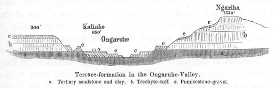
Two valleys, bordered by picturesque mountains, meet together at Katiaho, the Ongaruhe valley from the North, and the Mangakahu valley from the East. Between the two, opposite the settlement, arises the Ngariha mountain. The Ongaruhe is the main river; the Mangakahu only a small tributary; and Katiaho lies just opposite the junction of the two rivers on the right bank of the Ongaruhe. The latter rises in the Hurakia range, runs through an extensive table-land of pumice-stone, called Tetaraka, where it receives the Waimiha river rising at the Pukeokaku in the Rangitoto range, and reaches near Katiaho very nearly the size of the lower Waipa. It is here 40 to 50 feet wide and at an ordinary stage of water 8 to 10 feet deep. Below Katiaho, at the rapids of Pikopiko and Onehunga, which we had passed in the preceding night, it makes a sudden bend towards West, and 15 to 20 miles farther below, near Ngahuinga (i.e. coming together; junction), it empties into the Wanganui. 9
[Image of page 353]
The terrace formation, so remarkable on the Waipa, is still more marked in these as well as in all the other valleys of the Upper Wanganui district. There are here three terraces in the valley and as many on the declivities of the bordering hills. The former are cut into thick beds of pumicestone gravel, which fill the bottom of the valley; the latter into trachyte-tuff, composing the hills and mountains on the sides of the valley. To the ter-
races on the sides of the valley correspond farther up the valley extensive table-lands covered with pumicestone, and everything indicates to the observer that he is drawing nearer and nearer to a powerful volcanic hearth, from which those huge masses of pumice-stone and trachyte-tuff are originating.
Hoping to have a view of the Tongariro and Ruapahu, which we had approached by this time to within a distance of twenty-five miles, and in order to execute another series of observations for the compilation of a map, I ascended the Ngariha on the 10th of April. Although the mountain rises only 900 feet above the bottom of the valley, and is entirely free from woods, the ascent was nevertheless quite difficult, as we had to break our way through ferns of the size of a man. Bathed in perspiration, we at length arrived at the top; but we found ourselves amply rewarded for our toils by the view now presented to our eyes. Even the natives, who had accompanied us from Katiaho, and who had never before scaled this hill, were greatly surprised. The eyes of all turned in one direction. There lay the volcano Tongariro before us, all clear from foot to top. The still active cone, called by the natives Ngauruhoe, with its regular conical form arises majestically
[Image of page 354]
from the midst of a circular range shutting it in all around and open only on the Southwest, similar to the Vesuvius encircled by the Somma. The funnel-shaped crater at the summit of the cone could be distinctly seen, indeed almost looked into, the Westside of the crater being much lower, than the Eastside. Consequently the crater presented itself to us in the form of an ellipse, from which continually dense, white steam-clouds arose, which sometimes enshrouded the whole peak, and at other times were driven southward by the wind, which afforded us a view of the blackened edges of the Eastside of the crater. The generation of steam was to-day much stronger than at a former time, when I saw the mountain from Pukewhau. The natives assured me that the Westside of the crater had fallen in at the earthquake of Wellington in 1855, and that at that time also a second crater to the North had been active. Farther North, on the slope of the mountain, a briskly steaming solfatara was visible. The Tongariro was entirely clear of snow. But to the right of the Tongariro arose the towering mass of the Ruapahu; its summit wrapped in dense clouds, and below the cloud-cap, the snowfields of the peak were seen to reach down as far as an absolute height of about 7800 feet. At the base of these mountain-colosses, dark forests extended; but in the foreground, mountains with sharp edges and deeply fissured precipices; and at our feet the valleys with their long stretched terrace-lines. Thus we beheld in one glance the effects of fire and of water on the grandest scale in one and the same landscape-view.
My stay at Katiaho enabled me also to buy from a Maori for the price of one pound Sterling the pelvis of a small Moa which had been found near Teruakuaho a few miles above Katiaho on the Ongaruhe, under a cliff of the Herepu mountain. This was the first Moa relic, that fell into my hands, and I was not little gratified at the lucky circumstance.
April 11. The terminus of our to-day's journey was Petania at the foot of the Tuhua-mountain, a distance of about 16 miles from Katiaho. At the mouth of the Mangakahu we crossed the Ongaruhe by means of canoes, and followed the river up the
[Inserted page]
[Image of page 355]
valley in an easterly direction on a miserable road, which, in a manner very fatiguing to the traveller, led continually up and down over the terraces, through swamps, over numerous small creeks, and several times across the river itself. In the valley there was a successive change of grass, luxuriant shrubs and picturesque groups of Ti-trees. At a distance of three miles, the valley turns South-East towards the Tuhua-mountain, the most prominent point in the whole country, about 3400 feet high with a broad platform and a steep descent on its South side. At the bend of the river I counted no less than eight terraces on both sides. The valley here changes its character; it contracts into a rocky gorge shut in by vertical walls of trachytic rock, which present a beautiful columnar array, and through it the river rushes along over powerful blocks obstructing its course. About noon we reached a romantic spot, Koapaiari, where amongst sugarloaf-rocks of trachyte a small creek Komahina forms a picturesque cataract shaded by beautiful groups of trees and bushes. Here we stopped to make tea.
The Mangakahu there taking an eastward course, the road diverges from it, leading in a southerly direction over the terraces and over woodless hills with a steep ascent on to the table-land Pokomotu, 1386 feet above the level of the sea, at the western foot of the Tuhua mountain. This plateau is litterally covered with pumicestone. After having advanced about three miles, we came to the banks of the Piaua, a small stream running in a southerly direction to the Taringamotu river. Here a view was opened over the magnificent landscape at the junction of the Ongaruhe, Taringamotu and Wanganui rivers. The chief ornament of this landscape is the Hikurangi (i.e. ascending towards heaven), at the right between the Piaua and the Ongaruhe rivers, a volcanic cone of a very regular shape, rising from a very gently sloping base steeper and steeper to a height of 800 to 1000 feet, the top appearing as if cut smooth with a knife. Dark woods cover its declivities. The top is said to contain a water basin at the bottom of a funnel-shaped crater, and on the South-Eastside two powerful mineral springs (probably chalybeate) bubble out. In proceeding from the
[Image of page 356]
Piaua valley over low woodless hills, from which the Tongariro and Ruapahu are visible in all their grandeur and majesty, the traveller comes to the Taringamotu valley. We had no difficulty in wading through the river, as it rippled along over its broad shingle-bed, and proceeded up the valley along the left river-bank; crossed the river a second time and were in Petania (Bethany). Such is the Christian name of a Maori village formerly called Teterenga, and known also by the general designation Tuhua Settlement. It is situated at the southern foot of the Tuhua-mountain, 754 feet above the level of the sea. Our guide had to adjust various articles of his toilet before entering through the enclosure into the Kainga. The Maori-women also, who had joined our party from Katiaho, now began to adorn themselves, putting on an odd looking, towering head-dress made of plumes (Tauwakereru); the women in the village, on the other hand, commenced with doleful cries -- which, however, were merely intended to express friendly salutation -- to whine their "haere mai, haere mai ki konei", i.e. "come, come to this place", and after we had assembled all together at the place in front of the hut of the chief, they commenced in due form their Tangi, a lamentation, such as I had never heard before. They uttered the most doleful cries of anguish, clasping their hands now over the breast, now over the back, then bending low to the ground; thus expressing, by all sorts of convulsive motions their utter misery and anguish. This scene lasted for a whole hour without interruption; it was enough to move the stones to pity. But we could do nothing else than look on quietly and listen; for during all that doleful wail of lamentation the men stood in silent awe, wrapped in their blankets, without moving a muscle. Such is the Maori-custom, when friends or relatives happen to meet again after a long time of separation; they thus mutually lament their kindred, departed since the last meeting. The doleful scene ended at last in a general rubbing of noses and a cordial invitation to sit down to the meal, that had been prepared in the meantime; it consisted of potatoes, which were served steaming hot, in plaited baskets.
[Image of page 357]
April 12. -- Before breaking up I made some few purchases in Petania. From the chief I bought, for five shillings, after much parleying, a Moa leg-bone which he had carried for many years as a kind of club; I also enchanged a red woollen blanket for a piece of New Zealand national costume, a beautiful flax-mantle, Tatara, such as were in former times universally worn, before woollen blankets were introduced. Now-a-days such garments are only to be found in the remoter parts of the interior, where there is as yet but little intercourse with Europeans. They are now but rarely manufactured, the rising generation being unacquainted with that useful art. The distance from Petania to Lake Taupo is estimated a two days' journey. The road, however, is extremely difficult; it leads up and down from valley to valley, from mountain to mountain, across the ridges springing from the Tuhua-mountain in a southerly and southwesterly direction, and through dusky primeval forests. It traverses the sources of the Wanganui, and, ascending higher and higher, it finally reaches the watershed between the Wanganui and Lake Taupo. We were three whole days passing over this route. On the first day, after a most fatiguing passage through deep ravines cut into pumicestone gravel, we crossed the Takaputiraha range (1534 feet high), and encamped on the left bank of the Pungapunga river upon a beautiful grass-plain, called te Patate, 897 feet above the level of the sea.
April 13. -- We had now to scale the Puketapu, This mountain is the most remarkable point on the road from Tuhua to Lake Taupo. The ascent is extremely steep. According to my barometrical observations the height of the mountain is to be estimated at 2073 feet. As the summit was covered only with young underwood, I ordered the same to be cut down, and thus gained an interesting view of the sources of the Wanganui, over a sombre mountain-country and wood-landscape, in the back-ground of which the Ruapahu loomed up in all its majesty, its peak wrapt in clouds. Southwest of the Ruapahu another volcanic cone, 3000 feet high, was visible; it was pointed out to me as Hauhanga. To the Northwest and West the Tuhua-mountain and the Hikurangi-cone
[Image of page 358]
were the most prominent points. In clear weather, Mt. Egmont also is said to be visible from here. The Puketapu is moreover especially remarkable for the circumstance, that, in the midst of a landscape, in which every thing is covered by volcanic tuffs and pumicestone, it is composed of clay-slate of exactly the same description as at the Taupiri on the Waikato.
After leaving the Puketapu we were continually in the bush; it seemed as though it would never come to an end. Up and down, from ridge to ridge, from dale to dale; we passed the Waipari, then the Waione, cold creeks, the water of which showed a temperature as low as 50 deg. F. Again we had to climb up-hill, over roots and logs in the sombre dusk of the bush, the huge crowns of the tall forests trees shutting out the light of day, and the sky being moreover veiled by dark, dismal clouds of rain. The magnificent fern Leptopteris hymenophylloides grows in those damp woods with a extraordinary luxuriance, in the shape of the variety called superba. At length we came to a small creek flowing in a direction different from that of all the other creeks we had hitherto passed; it was the source of the Kuratao, running in a N.E. direction towards Lake Taupo, a sign that we had crossed the water-shed, and we hailed with joy the first indication of our having come quite close to our long looked-for destination. It was 5 o'clock p. m. when we emerged once more from the darkness of the bush into open daylight. Involuntarily we all with one accord burst out into a loud shout of joy, as we stepped out upon the open, grassy plain. Of the lake, however, the sight of which we had expected to greet our longing eyes, there was as yet nothing to be seen. But in its place two beautiful mountain-cones, the Kuharua and the Kakaramea, rose before us. We had reached a Pumicestone-plateau, called by the natives Moerangi, and I was greatly surprised at finding the result of my barometrical observations to show a height of 2188 feet. We pitched our tents by the banks of the Kuratao river, which, cutting through the pumicestone, forms a ravine about 100 feet deep with triple terraces.
[Image of page 359]
April 14. -- The distance from the lake was greater than we had supposed, and the day a dreary one, indicating rain. Travelling by turns through woods and lawns, we struck once more the Kuratao valley at Whakaironui, a potato-plantation at the margin of the plateau. The valley of the river is here already wider by far and deeper than at the place, where we had spent the night. We had to climb down over four terraces, a depth of about 400 feet and crossed the river at a point where it forms a picturesque cascade 20 feet high, thence rolling on in a narrow bed between vertical bluffs of trachyte-tuff. A bridge leads below the falls across the defile. 10 On the opposite side we were again obliged to climb over miserable, slippery paths, from terrace to terrace, up to the height of the pumicestone plateau, and arrived at the village Poaru, where we took our dinner. The distance between the latter place and the lake is three miles. After we had plodded along through marshy woods, we came to an open eminence, whence we had the first view of the lake. Like a sea it lay there spread out in the distance, without our being able to discern the opposite shore in consequence of the murky weather. Gently sloping down-hill, and passing along the foot of the Kuharua, -- a beautiful wood-clad mountain-cone, -- our path led us across a small creek Hauwai on to an elevation, from whence we saw the celebrated pah Pukawa, the residence of the great Maori-Chieftain Te Heuheu, situated beneath our feet at the margin of the lake.
It was a cold and dreary day, and now it moreover commenced to rain. "When strangers come, the mountains weep", is the Maori adage. I should have much preferred to have it read: "When strangers come, the sun doth smile", and that the latter version had proved true in our case.