CHAPTER XVII: Lake Taupo, Tongariro and Ruapahu.
[Image of page 360]
CHAPTER XVII
Lake Taupo, Tongariro and Ruapahu.
Rev. Mr. Grace. -- The Maori-Chief Te Heuheu. -- Lake Taupo. -- Volcanic cones at the South-shore. -- Hot springs of Te Rapa and Tokanu. -- The Waikato-Delta. -- The Volcano Tongariro, its cones and craters. -- Mr. Dyson's ascent of the Tongariro. -- Legends of the conflict between Tongariro and Taranaki. -- Ruapahu the highest mountain of the North-Island. -- Pumicestone-plateau. Terraces. -- Climate of the Taupo-country. -- Legend of Horomatangi. -- Population. -- Fauna. -- The East-shore of the lake. -- Rhyolite. -- Outlet of the Waikato.
The name Taupo reminds me of one of the grandest natural sceneries, I have ever seen, and at same time of the generous hospitality of the Rev. Mr. Grace and his amiable family. The missionary's house is only a few hundred yards distant from the Maori Pah Pukawa; picturesquely built against a bluff, upon a terrace 200 feet above the lake. Beneath its hospitable roof I passed five days, during which time I was engaged in sketching a detailed map of the lake. Mr. Grace, by virtue of his exact local knowledge, was of great assistance to me in this work; he accompanied me on my excursions, while the arrangements of the excellent lady of the house made us utterly forget, that we were sojourning in the remotest interior of New Zealand. The picture of that happy family circle, blessed with a number of blooming children, was truly calculated to awaken the most grateful emotions. How oddly contrasted with this picture the Maori-character, such as it was represented with all its former pagan splendour in the neighbouring Pah in the person of the celebrated Maori-Chieftain, Te Heuheu!
[Image of page 361]
Long ago I had hoard of the great and mighty Te Heuheu, residing in Pukawa at Lake Taupo. His name is known wherever the Maori-language is spoken; for he belongs to one of the oldest and most renowned noble families of the country, and is numbered among the heroes or demigods of his people. He had been pictured to me as a man of considerable talents, as the best and worst fellow at the same time, as proud, shrewd, generous, as a mysterious medley of modern civilization and ancient heathenism. I was curious to make his personal acquaintance, and had arranged with my travelling companions to pay the dreaded potentate of the country a visit of respect and homage in all due form. Having employed, however, the first day of my stay, -- on account of the fine weather, -- for an excursion to the hot springs near Tokanu, it was not until the second day after my arrival at the lake, that I carried my purpose into execution.
Mr. Grace accompanied me to the Pah. It is situated upon a peninsular projection into the lake, with an enclosure of strong palisades, through which two sliding gates give admittance. Entering through one of the gates we came to an oblong place at the upper end of which a sightly provision-house (Pataka) first attracted our attention. It was painted red, and based upon four round posts, to protect the provision-supplies stored within from the voracity of the rats. Its front was ornamented with extravagant carvings after the style of art peculiar to the Maoris. Neat flourishes and arabesque-like figures alternated upon the gable-field with grotesque, big-headed and big-eyed human forms. Opposite the this Pataka stood an unsightly hut without any architectonic ornament whatever, but with a little porch beneath the protruding roof in front, as is customary in all Maori-huts of better quality, -- it was Te Heuheu's residence and in the verandah of that Maori-palace sat a man of stern and gloomy mien, wrapt in a dirty woollen blanket, -- it was Te Heuheu himself.
My reception at his hands was any thing but a gracious one. It was not until the missionary had spoken with the chieftain, that the latter condescended to extend his hand to me, inviting me, to
[Image of page 362]
seat myself beside him upon the unrolled mat. He scanned with his flashing, black eyes the group of my companions, who saluted him most reverentially, and then addressed to me the little amiable question, whether I was aware, that the natives, I had with me as guides and carriers, were not slaves, but the sons of free and independent chiefs, which interrogatory was followed by a long, expatiation. Te Heuheu stated that he was always glad to become acquainted with independent Europeans of better rank and station, they always being worthy people, who meet and treat the natives with due respect; that, on the other hand, the common Europeans such as run-away-sailors and other rabble, with which New Zealand was flooded from Europe and Australia, were detested by him as the worst and most contemptible kind of people; that, numbering me among the former class, he had expected my visit already the day before, and made all suitable preparations to receive me with all due form as well as with a cordial welcome; but that, as I did not choose to come at the expected time, it was my own fault, if I found him to-day in his ordinary every-day-clothes. It required repeated apologies, and various explanations to propitiate the offended pride of the noble chief; yet I must state
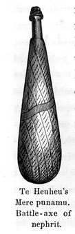
to his credit, that he did not bear me a long grudge; for on the same day he ordered a fat pig to be killed for my Maoris, and, moreover, entertained them in his Pah through full five days without accepting any pay whatever in return. He also showed me a magnificent Mere punamu, a battle axe, 15 inches long, and cut out of the most beautiful, transparent nephrite, an heirloom of his illustrious ancestors, which he kept as a sacred relic. He explained to me that this murderous weapon was taken from a hostile chief in bloody combat, that five times already it had been buried with his ancestors, and that the notch on one side of it dated from the last fatal blow struck at a hard skull. A second piece, which he showed me with much pride, was an English saddle, which, with a horse, had been presented to him
[Image of page 363]
years ago by Sir George Grey, in acknowledgment of his services as guide and travelling companion on a journey to Lake Taupo. Iwikau Te Heuheu has five wives, and at the time of our visit he expressed himself inclined to take two more. He is the worthy sire of a numerous progeny, his pride and his joy; but, although not quite averse to Christianity, he has always refused to be baptized, fearing to lose by such a step his influence and authority as chief, which is based upon various pagan notions, especially upon his supposed power over the evil spirits of the earth, water and air. He is of middle size, delicately rather than robustly built, wearing his black hair in long locks. His beardless face, but imperfectly tattooed upon the right cheek, with the small sparkling eyes characterized him to me as a man of cunning, calculating shrewdness. He has nothing of the imposing, majestic hero-stature of his deceased brother Tukino Te Heuheu, who is said to have been a giant nearly seven feet high with silvery hair, the great man, to whom the present Te Heuheus owe their fame and authority. Tukino Te Heuheu had met his death by an awful catastrophe in May 1846, in the neighbouring village Te Rapa. He was burried alive with his six wives and fifty-four persons by a land-slip connected with a flood, which occurred during night time. Iwikau had the corpse of his brother exhumed from the entombed village, and accorded him a solemn interment. According to Maori custom in the case of great chiefs, the remains were disinterred after some years, laid out upon a kind of bed-of-state, and preserved in a magnificently carved coffin. The sacred remains were intended to be then conveyed to the summit of the Tongariro; for the deep crater of the volcano was intended to be the final grave of the hero, with the heaven-ascending pyramid of scoriae and ashes for his monument. But the grand idea was but half carried out. As the bearers were approaching the top of the ever steaming cone, a subterraneous roaring noise became audible, and awe-struck they deposited their heavy load upon a projecting rock. There the remains still lie. The mountain, however, is most strictly tapu, and nobody is allowed to ascend it.
[Image of page 364]
The present Te Heuheu, moreover, erected in his memory a mausoleum (Wahi-tapu), said to have been a master-piece of Maori-architecture. All we found remaining of it, were at the lower end of the Pah, under picturesque groups of Karaka and Kowai trees, several artificially carved posts with most note-worthy representations, which all seemed to have reference to the inexhaustible manly vigour of the departed hero and to the prolificness of his numerous wives. Within the enclosure of the Pah there live besides Te Heuheu only his nearest kinsmen and friends. In the lower part I noticed moreover, a cucumber-patch, and a piece of a vineyard, started by the Rev. Mr. Taylor, but now utterly neglected. The vines were full of grapes, which, however, were sour and utterly unfit to eat. Outside the Pah various huts are scattered about, the dwellings of Te Heuheu's subjects.
The proud chief returned my visit in an elegant suit of black. Many another hour did I sit together with the interesting man during my stay at Pukawa, listening to his observations and recitals. It is from his lips, that I have the interesting legends, which in the tradition of the Maoris are attached to the Taupo country, and which I shall recite here-after. In his political views, he proved himself a zealous advocate of the national party, avowing most solemnly, that he would never visit again the "Pakeha-City" Auckland, where at his last visit he had been treated like a dog. At our departure he sent me word through the missionary, that he would be glad to receive and keep me again at any future time; that however he warned the Englishman, who accompanied me by order of the Governor, from a second visit to his Pah; stating that he had tolerated the latter only on my account, I being a stranger and not master of the Maori-language.
That was Te Heuheu, one of the few surviving representatives of the old heathen-times, around whose head there is still a faint halo of that romantic heroism, which like a dim, dark legend reminds us of the classical age of a savage cannibal people, hastening, under the influences of European civilization, with rapid strides towards its final extinction.
[Inserted page]
[Image of page 365]
Many other interesting personages of the higher Maori-aristocracy at Lake Taupo might be characterised, such as Te Heuheu's rival in Tokanu, the sullen Herekiekie; or the fat postmaster Puhipi, the David of the Maori Jerusalem (Hiruharama, a village at the Northend of the lake), a famous gormandizer; but let us look now upon the lake and its environs.
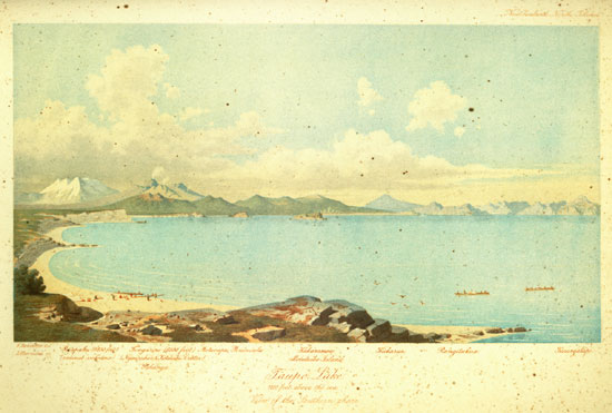
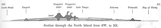
Lake Taupo 1 is a real inland-sea, 25 miles long from Southwest to Northeast, its greatest breadth about the 20 miles, and of a depth as yet not fathomed. It lies 1250 feet above the level of the sea; this is the mean result of a number of barometrical observations which I made at the shores of the lake. Dieffenbach fixed its height from the temperature of the boiling water at 1337 feet. The lake is everywhere surrounded with volcanic formations. Quartzous trachytic lavas, -- which of late have been distinguished from the common trachyte by the name of rhyolite, -- in the most different modifications of structure and colors (crystalline and vitreous), together with huge masses of pumicestone, are the prevailing rocks. They form round about the lake a high table-land from 2000 to 2200 feet above the level of the sea, upon which numerous volcanic cones arise built up of trachyte, phonolite, trachy-dolerite or andesite, and partly also of basalt. The lake itself evidently owes its origin to a break in the plateau, and seems to be of an extraordinary depth especially in its western half.
The West shore of the lake is formed by vertical bluffs of rocks, which near Karangahape, at a promontory projecting far into the lake, attain a height of more than 1000 feet. Upon that side of the lake a landing is practicable only at the few points where little rivers empty into the lake. The long-stretched wooded ridges of the Rangitoto and Tuhua mountains, rising to a height of 3000 feet above the level of the sea, shut out the horizon in a northwesterly direction, and only one point attracts the attention
[Image of page 366]
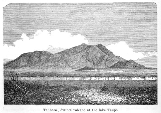
by its rather singular form, -- I am speaking of the Titiraupenga mountain, from the summit of which a bare pyramid towers up, resembling a ruined castle. The East shore in its greatest part is flat, and formed by a broad sand-beach, upon which the road leads along the lake. Widely gleaming, white pumicestone cliffs border the strand. Above them extend pumicestone-plains, covered with grass and bushes, which rise in terraces up to the foot of a high wooded range, which under the name of Kaimanawa forms the continuation of the Ruahine-chain in the province of Wellington, and, together with this chain, is to be considered as a continuation of the Southern Alps of South Island. The foot of the range is ten to fifteen miles from the East shore of the lake; behind the wooded ranges, rocky, pyramidal peaks tower to the sky, which attain a height of 6000 feet and more above the level of the sea, and present with their rugged Alpine character a picturesque contrast to the regular conical shape of the volcanic mountains on the South side of the lake. Farther to the N.E. the mountains are growing lower, and bear the name of Te Whaiti. The range in its whole length from Cooks Strait to the East Cape, was and for the greater part is still a terra incognita, and if there is anywhere upon the North Island a prospect of finding gold, silver and other metals, it is in those unexplored mountain-chains. I was greatly surprised at the sight of them, because I had not found upon any map of New Zealand even the least intimation of the existence, between Lake Taupo and the East-coast, of such a high chain of mountains. In that range all the numerous and partly considerable rivers rise, which empty into the lake from the East. The detritus, which they carry with them, consists mostly of bluish slate, and of gray sandstone. At the North-end of Lake Taupo the beautiful cone of the Tauhara points out the region, where the Waikato leaves the lake, as a stream of a quite considerable size. By far the most attractive parts, however, are the southern shores. They are bordered by a successive series of picturesque volcanic cones, behind which the Tongariro and Ruapahu rear their lofty heads. From the South-shore itself those two giants
[Image of page 367]
are not visible; but from the East- and North-shores they are everywhere seen towering high above those lower mountain-cones, by the natives so well designated their wives and children. Their names are: Pihanga, Kakaramea, Kuharua, Puke Kaikiore and Rangitukua. Pihanga, the eastern one of those cones, is also the highest. I estimate its height at 3500 feet above the level of the sea. Only its topmost peak, cleft by a deep chasm, is woodless, and displays already from a far a crater open towards North. Likewise the Kakaramea, the summit of which is of a red colour, bears probably a crater. Both craters are deemed extinct; but, the volcanic forces below have by no means been as yet lulled to their final repose; for on the northern declivity and at the foot of the Kakaramea it steams and bubbles and boils in more than a hundred places.
I visited those hot springs on the very first day after my arrival at the lake in company of the Rev. Mr. Grace. East of Pukawa, in the rear of a steep promontory, a small bay extends south. The western-shore of this cove is formed by vertical bluffs consisting of alternating horizontal banks of trachyte, trachytic conglomerate and tuff. A small creek, the Waihi, plunges quite close to the South-end of the cove, in a magnificent fall about 150 feet high over this bluff of rocks. At this cascade the mountains recede somewhat from the lake; and here already, from the conglomerate-layers forming the beach, hot water, of 125 deg. to 153 deg. F., is seen bubbling forth. By conducting this water into artificial basins, the natives have prepared several bathing-places, the water in which showed a temperature of 93 deg. F. Conferves of a magnificent emerald-green cover the places, where the water flows, and silicious, not calcareous, sinter is deposited in them. But strange to say, there is amid those alkaline springs also a chalybeate one of 156.5 deg. F., which deposits large quantities of iron ochre. Above these springs on the side of the mountain, probably 500 feet above the lake, steam issues from innumerable places. The whole Northside of the Kakaramea mountain seems to have been boiled soft by hot steam, and to be on the point of falling in. From every
[Image of page 368]
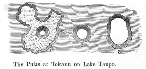
crack and cleft on that side of the mountain hot steam and boiling water are streaming forth with a continual fizzing noise, as though hundreds of steam-engines were in motion. Those steaming fissures in the mountain-side, upon which every stone is decomposed into reddish clay, the natives call Hipaoa, i.e. the chimneys, and it was at the foot of that mountain-side, that in the year 1846 the village Te Rapa was overwhelmed by an avalanche of mud, and the great Te Heuheu perished. The inhabitants of the Pah Koroiti upon the mountain terrace near the Waihi-falls use those steam-holes for cooking their victuals over them. The little cold brook, which empties into the lake at Te Rapa, is called Omohu. The chief range of springs, however, is on the Southside of that cove near the Maori village Tokanu at the river of the same name. From the small mountain-cone Maunganamu to the mouth of the Tokanu river it comprises an area of about two square-miles. It is, impossible, to describe every single point; I will therefore mention only the principal springs.
The powerful column of steam visible far over the lake-shore, which is seen to ascend at Tokanu, belongs to the large fountain Pirori. Pirori signifies fountain, eddy. From a deep hole on the left hand bank of the river Tokanu, a boiling-hot water column of two feet diameter, always accompanied by a rapid development of steam, is whirling up to a height of six to ten feet. The natives, however, told me, that the water was frequently thrown up with a booming noise to a height of more than forty feet. At a few paces from it there is a basin eight feet wide and six deep, covered with a silicious deposit resembling chalcedony; it is called Te Korokoro-otopohinga, the jaws of Topohinga, in which the water is continually boiling. Farther-on we came to a warm creek Te Atakokoreke with a temperature of 113 deg. F., a favorite bathing-place of the natives. On the other side of the creek, there are three basins close together. Te Puia-nui, the large spout, was filled with clear, and but gently bubbling water of 186.8 deg. F. 2 to
[Image of page 369]
the very brim so that it ran over into the second basin. In this basin, eight feet wide, grayish white mud was boiling, which showed a temperature of 188 deg. F.
The third basin contained again clear boiling water. All three basins are lined with crusts of silicious deposit, and bear to each other a relation of periodical exchange, so that No. 1 is filled, while in Nos. 2 and 3 the water falls, and vice versa. The natives likewise assert, that the middle basin which I beheld only as a boiling mud pool, was in March and April of 1846 an immense geyser, throwing out a spout of hot water to a height of nearly 100 feet, so that the village was completely flooded by it. It is evident also from other sources, that in that range of springs continual changes are going on, and that those phenomena are periodical with a great many of the springs, similar to the Geyser and Strokkr in Iceland.
A crust of silicious deposit, three feet thick, under which fine clayey mud is bedded, covers the larger portion of the spring-region. In smaller apertures, from which nothing but hot steam emanates, the thermometer rises to 208 deg. F. Here also the natives employ the steam-fissures for cooking; they have special huts for the winter, erected upon warm ground. They call the hot springs Puia, distinguishing Papa Puia, springs with clear water, yielding silicious deposits, and Uku Puia, the boiling mud-pools and small mud cones. Of sulphuric acid or of sulphuretted hydrogen I could discover in this spring-region only faint traces. I believe, if any one at Tokanu or on the declivity of the Karakamea would endeavour to count the several spots, which give out either hot water, steam, or boiling mud, he would find more than 500 of them. This, however, is only one, nor by far the most important of those numerous hot spring regions of the North Island. 3
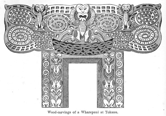
The settlement Tokanu is noted for a magnificent Wharepuni,
[Image of page 370]
a remnant of the good old times of the Maoris. The annexed wood-cut is intended to illustrate some carvings on the door-posts.
One figure had fallen off the roof, and lay on the ground in dust and dirt. I wished to purchase it from the chief of the place; he, however, was much astonished on hearing my demand, and informed me, that the figure in question represented his grand-father, and that it was utterly impossible for him to sell his grand-father to a Pakeha.
The fertile low-lands about Tokanu are already to be considered as a part of the extensive delta of the Waikato river, which here, at the South-East side, flows into the lake. The river in its delta is divided into four branches; the natives, however, very strangely do not call it Waikato, but Tongariro, like the village situated on its bank not far from the mouth. It is formed by two rivers uniting at the foot of the Pihanga, the one coming from the South bearing the name of Waikato, the sources of which are at the Tongariro and Ruapahu; the other, rising in the Kai-
[Image of page 371]
manawa range, and, as it seems, the larger branch, retaining the name Tongariro. Evidently it would have been more correct to name the tributary coming from the Tongariro volcano also Tongariro, and to leave the name Waikato to the main-river. Consequently, according to the Maori nomenclature, the Waikato loses its name for the distance from its junction with the Tongariro river to its influx into Lake Taupo.
The foot of the Tongariro is about twelve miles distant from the lake. Between the volcano and the Pihanga and Kakaramea mountains lying before it, there intervenes a broad valley with the beautiful lake Rotoaira, three miles long. The outlet of this lake, the Poutu, is one of the principal tributaries of the Waikato. Dieffenbach mentions here also another smaller lake Roto Punamu, shut in round about by mountains as in a crater-basin, 2417 feet above the level of the sea. In order to scale the Tongariro, it is necessary to set out from lake Rotoaira. However, the difficulties which the natives oppose to such designs, are the same now, as in 1841, when Dieffenbach was endeavouring in vain to obtain permission to ascend the mountain; or in 1850, when the same thing occurred to Sir George Grey. The mountain is tapu; and even, should Te Heuheu let himself be persuaded, to give his consent to scaling the mountain, Te Herekiekie most certainly would oppose it the more determinately. The only two Europeans, who are said to have been on the top, carried out their purpose without the least knowledge of the natives. 4 I made
[Image of page 372]
no attempt to extort a permission, or to elude the natives, as the weather was much too bad for such an undertaking, and only a greater expense of time, such as a thorough exploration of the volcano necessarily required, could have led to any satisfactory result. Nevertheless I deem myself capable of contributing something to a better understanding of the Tongariro system, and will endeavour to describe the several portions of that grand volcanic mountain according to the knowledge which I gained from the West- and North-sides, of course only at a distance of several miles; yet, with objects so grand, the general proportions are much more easily and therefore often much more correctly viewed at a greater distance, than by climbing for whole days along the colossal sides. The Tongariro is not a single mountain like the Ruapahu, but is composed of a whole group of mountain-cones. The beautiful cone, towering high above the other parts of the group, is distinguished by the special name of Ngauruhoe. 5 It bears a funnel-shaped top-crater, the principal active one of the Tongariro. The Ngauruhoe together with the grand circular range, from the centre of which it rears its head, forms the southern portion of the Tongariro system. It is a cinder-cone of the most regular conical shape with a slope of 30 to 35 degrees; the height from the basis to the top I estimate at 1600 feet. It overtops the heighest points of the other parts of the system by about 500 feet and attains probably an absolute height of 6500 feet above the level of the sea. 6 The outer circus, shelving off inside with steep walls, and from all appearances forming a grand mountain-amphitheater with rocky precipices of 1000 feet in height, is opened on the West-side by a broad chasm; and no doubt, it is through this chasm, from the atrium between the cone of cinder and its circumvallation the that chief-source of the Wanganui river flows. This seems also
[Image of page 373]
to be the only side, from which the cone is accessible, and those who did ascend the mountain, must necessarily have chosen this direction.
I have never heard of any native having been at the top. The dread of the demoniac powers of the lower regions seems to have kept them from such an undertaking; and the mountain was tapu. As far as I can learn, as yet only two Europeans have succeeded in ascending the Ngauruhoe, Mr. Bidwill in March 1839, and Mr. Dyson in March 1851. Dyson's account of his adventures during the ascent, was communicated to the 'New Zealander' by Dr. A.S. Thomson, as follows:
In the month of March, 1851, a little before sunrise I commenced my ascent alone, from the northwestern side of the Rotoaire lake. I crossed the plain and ascended the space to the northward of the Whanganui river. Here I got into a valley covered with large blocks of scoriae, which made my progress very difficult. At the bottom of the valley runs the Whanganui river. After crossing the river, which at this place was then not more than a yard broad, I had to ascend the other side of the valley, which, from the unequal nature of the ground, was very tedious, and I kept onwards as straight as I could for the top of the mountain. At last I came to the base of the cone, around which there were large blocks of scoria which had evidently been vomited out of the crater, and had rolled down the cone. The most formidable part of my journey lay yet before me, namely the ascent of the cone, and it appeared to me from the position where I stood that it composed nearly one fourth of the total height of the mountain. I cannot say at what angle the cone lies, but I had to crawl up a considerable portion of it on my hands and feet, and as it is covered with loose cinders and ashes, I often slid down again several feet. There was no snow on the cone or the mountain, unless in some crevices to which the sun's rays did not penetrate. There was not on the cone any vegetation, not even the long wiry grass which grows in scanty patches up to the very base of the cone. 7 The ascent of the cone took me, I should think, four hours at least; but as I had no watch, it is possible from the laborious occupation I was at, that the ascent of the cone looked longer as it was. But whether it was three hours or four that I was clambering
[Image of page 374]
up the cone I recollect I hailed with delight the mouth of the great chimney up which I had been toiling. The sun had just begun to dip, and I thought it might be about 1 p.m., so that I had ascended the mountain from the Rotoaire lake in about eight hours. I must confess as I had scarcely any food with me that I kept pushing on at a good pace. On the top of Tongariro I expected to behold a magnificent prospect, but the day was now clowdy and I could see no distance. The crater is nearly circular, and from afterwards measuring with the eye a piece of ground about the same size, I should think it was six hundred yards in diameter. 8 The lip of the crater was sharp: outside there was almost nothing but loose cinders and ashes; inside of the crater there were large overhanging rocks of a pale yellow colour, evidently produced by the sublimation of sulphur. The lip of the crater is not of equal height all round, but I think I could have walked round it. The southern side is the highest, and the northern, where I stood, the lowest. There was no possible way of descending the crater. I stretched out my neck and looked down the fearful abyss which lay gaping before me, but my sight was obstructed by large clouds of steam or vapour, and I don't think I saw thirty feet down. I dropped into the crater several large stones, and it made me shudder to hear some of them resounding as I supposed from rock to rock, --- of some of the stones thrown in I heard nothing. There was a low murmuring sound during the whole time I was at the top, such as you hear at the boiling springs at Rotomahana and Taupo, and which is not unlike the noise heard in a steam engine room when the engine is at work. There was no eruption of water or ashes during the time I was there, nor was there any appearance that there had been one lately. I saw no lava which had a recent appearance; 9 notwithstanding all this, I did not feel comfortable where I stood in case of an eruption. The air was not cold -- the ascent had made me hot -- but I had time to cool, for I remained at the crater nearly an hour. At about 2 p.m., I commenced my descent by the same way that I ascended. A fog or cloud passed over where I was, and caused me to lose my way for a short time. When descending I saw between Tongariro and Ruapahu a lake about a mile in diameter. I could see no stream flowing out of it on its western side. An extinct crater may also be seen near the base of Tongariro. It was almost dark before I reached the Whanganui river, and,
[Image of page 375]
although in strong condition and a good walker, I felt completely done up, and I fell asleep in a dry water-course. The night was cold, but I slept soundly until daylight, when I immediately rose and continued my descent, and at 10, a.m., I reached my residence at Rotoaire, with the shoes almost torn off my feet.
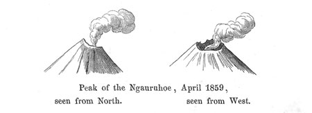
This account agrees in its main-points perfectly with Mr. Bidwill's descriptions. 10 The Ngauruhoe crater, consequently, seems to be at present in the state of a solfatara throwing out continually large masses of steam and other kinds of vapour. The natives know nothing of lava-flows; yet from time to time the crater is said to eject cinders and hot mud, and during such eruptions, now and then, a fiery shine is said to be visible over the mountain. 11 Such is specially said to have been the case in the month of February, in 1857, when the ejection of cinders and ashes lasted from two to three weeks. Such ejections seem to exercise a changing influence upon the topmost craterlip. I always saw the point of the
cone such, that it was evident, the western lip of the crater was necessarily much lower than the eastern. A trifling change however, seems to have taken place since, concerning which my friend Dr. Haast writes to me as follows: Mr. Ch. Smith of Whanganui sojourned in the month of December 1859 in Tokanu at Lake Taupo for the purpose of negotiating with Te Herekiekie, the chief of that district, concerning a pasture for sheep. He related
[Image of page 376]
to me, that in the first days of December, with a cloudless sky, but an oppressively sultry atmosphere, about 11 a.m. suddenly a subterraneous noise like thunder was heard, lasting for the space of 1 1/2 hours; meanwhile, there was not the least concussion of the ground noticeable, such as is generally felt during an earthquake, and Lake Taupo was quiet as before. Only the hot springs of Tokanu were in an unusual commotion, throwing out intermittent spouts of water with great power to the height of 30 feet. The natives at once ascribed the roaring noise to the Tongariro, the top of which, however, is not visible from Tokanu on account of the protruding Pihanga. A week later, on his return via Onetapu, Mr. Smith noticed with great astonishment, that the Ngauruhoe, which a fortnight before when seen from the same point, showed an unbroken peak, was now broken in and had two sharp horns. There being nothing seen of an ejection of ashes or other substances, the whole seems to have been an eruption of vapors and hot water, which in connection with an explosion burst the upper crater-lip.
The Ngauruhoe does not reach the limit of perpetual snow; yet, the native assured me, that in winter-time, when the lower parts of the mountain are covered with snow, the latter would not stick to the Ngauruhoe; so that the whole cone seems to be heated from within.
The Ngauruhoe, however, is not the only crater in the Tongariro system. Bidwill mentions, that from the top of the Ngauruhoe towards the north he noticed upon another part of the Tongariro a circular lake. This remark most probably has reference to the truncated peak immediately north of the Ngauruhoe, which the natives designate as Ketetahi, the crater of which acts periodically. In the year 1855, at the time of the earthquake in Wellington, an eruption of ashes seems to have taken place from it, and the mountain is since seen to steam from time to time. From the Northend of Lake Taupo, on the 21th April, I saw large and dense volumes of steam, larger than those from Ngauruhoe, emerging from the Ketetahi crater. To the northwest of the Ketetahi there
[Image of page 377]
is a third cone, likewise truncated, and nearly 6000 feet high. Concerning the condition of its top I an unable to give any positive information; I merely suppose, that it also contains a deep crater. On its northern side, at a height of about 4000 feet above the level of the sea a fissure is to be seen, from which, as from the Ngauruhoe crater, dense clouds of steam are continually streaming forth. This seems to be a great solfatara. The hot sulphurous springs of that solfatara are often visited by the natives on account of the relief they experience in cutaneous diseases. The outlet of these hot springs flows into the Rotoaire. A fourth cone, north of the Ketetahi, or northeast of the last mentioned cone, shows on its northwestern slope, at a height of about 3500 feet above the level of the sea, a crater, apparently entirely extinct. From the East-shore of Lake Taupo, to the right of the Pihanga, the dark black hole can be plainly seen.
Although this grand volcano with its various craters, has within the last centuries, as far as it is known, not had any eruption of lava, yet I would not venture to assert, that such might not suddenly recur again. At present it is in the state of a solfatara. Earthquakes of such vehemence, as they have occurred at a distance from this central point of volcanic activity upon the North and South Islands at various coast-points (Wellington, Wanganui, Cloudy Bay), are not known in the Taupo district; light shocks, on the other hand, accompanied by a subterraneous noise, are no rare occurrence.
South of the Tongariro rises the Ruapahu. The feet of the two mountains gently slope together forming a plateau about ten miles wide and 2200 feet above the level of the sea. Upon this plateau four lakes are said to lie, two of them about three miles long, the other two smaller. One of these lakes is called Taranaki; its outlet flows into the Wanganui. The natives have a peculiar legend to the effect, that a third giant, named Taranaki, formerly stood by the side of Tongariro and Ruapahu. They were friends until Taranaki attempted to carry off Pihanga, the wife of Tongariro. This brought about a conflict between Tongariro and
[Image of page 378]
Taranaki. Taranaki was worsted in combat and compelled to flee; he hastened down the Wanganui, drawing the deep furrow of that river. He fled as far as the sea, where he now stands in solitary grandeur, the magnificent snow-capped beacon of Mount Egmont (8270 feet). In his flight, however, two pieces were torn off; and the natives show to this very day two blocks of rock as the fragments torn off the Taranaki masses, which, differing in their nature from the formations contiguous to the Wanganui, lie at a distance of 18 miles from the source of the river at Waitotara.
The Ruapahu 12 has the shape of a truncated cone, towering up into the regions of perpetual snow. No one has ever ascended or explored it. Nevertheless there can be no doubt as to its volcanic nature, but it seems to be perfectly extinct; there is no trace of a solfatara to be discerned in the distance either at its sides or at the top; and it is totally unknown whether the broad summit forms a plateau, or whether it contains a crater. 13 The mountain is but rarely free from clouds; and if once the weather happens to be clear, large snowfields are seen covering the summit, and running down along the fissures, by which the slope of the mountain is channelled, as though they terminated in glaciers. The limit of perpetual snow in the latitude of the Ruapahu (39 deg. 20'), is at a height of about 7800 feet, and to judge by the colossal extent of the snow-fields even in midsummer, the mountain appears to reach a height of 9000 to 10,000 feet above the level of the sea. 14 At any rate the Ruapahu is by far the highest mountain of the North Island. A portion of the mountain bears the name of Paratetaitonga. At the eastern declivity of the Ruapahu rises the southernmost source of the Waikato. It forms a waterfall according to
[Image of page 379]
the statement the natives; and 50 yards from the source of the Waikato, the source of the Wangaehu is said to lie, which flows South, and empties into Cooks strait East of the mouth of the Wanganui river. Its water, the natives say, has a milky color, and a bitter, astringent taste.
The pumicestone plateau, upon which the Tongariro and Ruapahu rear their colossal heads, assumes on the South-East side of the Ruapahu, where it forms the watershed between the Waikato and Wangaehu, the character of a sandy desert. The natives call the plateau Rangipo, and the sandy desert Onetapu. Superstitious notions are connected with this sandy plain. The road from Lake Taupo to Wanganui, the so-called Rangipo-Road leads over it, and the natives have driven pegs into the ground in order to point out the direction of the road.
From the southern foot of the Ruapahu the country slopes gradually towards Cooks strait in the same manner as from the North-end of Lake Taupo towards the Bay of Plenty. It consists on both sides principally of pumicestone, pumicestone-tuffs and rhyolite lavas, and it can be justly said, that the foot of the two volcanic colosses reaches from sea to sea.
Consequently the Taupo volcanoes arise upon a huge flat cone, which was formed by the first submarine eruptions, and rose only gradually by the upheaving of the land above the sea. In close connection with this rising is the terrace-formation in all the river-valleys of that cone, a phenomenon which is very characteristically marked on the shores of Lake Taupo. The first terrace is at Pukawa about 100 feet above the present level of the lake. It is covered with the sand- and boulder-alluvium of the lake, and so very characteristic that even the natives could not help noticing it.
[Image of page 380]
They say, that in former times before the breaking through of the Waikato to the North, the lake had stood at that height. The second terrace is 300 to 400 feet above the lake, and forms extensive plains round about the lake. Yet, it is only the third stage that leads on to the pumicestone table-land 700 to 800 feet above the lake. The formation of the terraces is most perfect in the Kuratao and Waikato valley upward from the lake, and along the eastern side of the lake.
The climate of the Taupo-district is not so mild, as the climate of the coast districts; especially the winter-season is cold and chilly. The rough blasts so frequent here are partly to be ascribed to the high mountain-ranges of the country. 15 We had sufficient proofs of it. The weather, unusually fine and pleasant in the first half of April, had undergone a total change during our stay at Pukawa. The bright aftersummer was followed by a rough and blustering autumn. On the 15th April, after a long calm, suddenly a N.W. gale broke forth, which became really dangerous during our passage across the small southern cove of the lake near Te Rapa, our canoe being very rudely tossed to and fro by the squally waves of the lake. The Northwester was followed on the 16th April by chilly blasts from southwest, which lasted three whole days, accompanied by heavy showers of rain and pelting hailstorms. In the mountains it snowed. The temperature fell during those storms at night as low as 38 deg. 7 F., nor did it rise even during the day above 54 deg. 5 F., so that we found the chimney-fire at Mr. Grace's quite comfortable. The lake during those days presented the appearance of a wild sea. White-foaming surges were rolling towards the shore, producing a roaring surf as at the open sea-coast; terrible blasts came breaking forth from the ravines and valleys on the South-side of the lake. In mad uproar they swept
[Image of page 381]
over the watery plain, and where they met together from opposite directions, eddies were formed from which the spray was dashed high into the air. Whoever happens to be overtaken by such weather in a canoe upon the lake, is irrevocably lost. The lake, therefore, for the imperfect vessels of the natives, -- here called tiwai, -- is much more dangerous, than even the open sea, because the fresh water is much more easily stirred up by the wind than the salt water, forming short, tumbling waves; moreover the shores present but few landing-places. The natives therefore, are extremely cautious, venturing on longer trips, only, when they can safely rely upon serene weather. Nevertheless fatal accidents are of frequent occurrence, and every dweller near the treacherous water tell of cases, when he had a hair-breadth escape from the grasp can of the hungry sea-sprite (Taniwha) Horomatangi, haunting that spot, according to tradition, and stirring up bad weather.
Horomatangi is said to be an old man and as red as fire. Thus the natives assert to have seen him. He lives in a cave on the island Motutaiko in the lake. There he watches the passing canoes, dashing forth from his lurking-place as soon as he espies one. He churns up the water into mad surges bubbling up like the big spout Pirori near Tokanu; together with the water he throws up large stones, which falling upon the passing canoes upset them. He devours whatever comes within his reach; carrying on his work of treachery and destruction both in fine and bad weather. The natives point out a place, situated almost in the centre of the lake between the island Motutaiko and Te Karaka Point, as chiefly dangerous, avoiding even in the finest weather to venture here too close to the haunt of the evil spirit. Even when the general surface of the lake appears smooth, the water on this spot is in boiling commotion; in stormy weather it appears as one large patch of foam. The canoes passing over it are said to be turned from their course. These phenomena being real matters of fact, the observer might be tempted to suppose the existence of a spouting submarine spring at that place, or even of submarine volcanic eruptions; for such an explanation, however, further indications are wanting, and
[Image of page 382]
it is perhaps nothing but a current disturbed by the transverse influx of several extensive streams of water, which current passes through from the influx of the Waikato to where the river leaves the lake, and makes itself specially felt at that place. By supposing the existence of such a current, we likewise have an explanation for the assertion of the natives, that the canoes at that place are always turned in a direction from southwest to northeast.
Horomatangi has moreover special relatives, the Kaukapapas, distinguished by peculiar attributes, and on that account held in great esteem. Te Toko of Ornanui, a village north of Lake Taupo, is said to be such a Kaukapapa, often disappearing suddenly, reappearing at Lake Rotorua, and returning with equal suddenness. In like manner Te Ihu at Tapuaiharuru is reported as being able to live with Horomatangi under water in the cave on the Island Motutaiko. Incredulous minds, of course, assert, that this cave, the entrance to which is under water, rises higher at some distance from its mouth, being quite dry there, so that a man can very easily live in it. Such and a great many similar stories are in vogue about the lake. -- Yet, sooner or later, I thought, the time will come, when well-constructed vessels of European style, when even steam-boats will navigate this magnificent lake. Then the reign of those dreaded Taniwhas will be at an end for ever.
The temperature of the lake I always found to be several degrees higher than the temperature of the brooks and rivers running into it; on the 15th April, at Pukawa, the lake-water had a temperature of 59 deg. F.; during the cold days from the 16th to the 18th of April the temperature fell; and on the 19th and 20th April I observed at several points of the East-shore 58 deg. to 60 deg. F., while none of the tributary rivers showed more than 56 deg. F. 16
The population about the lake was estimated by Dieffenbach in 1841 at 3200 inhabitants; in 1859 there were only 2000, living
[Image of page 383]
scattered in numerous villages about the lake. The settlements are nearly all situated at the mouths of the rivers running into the lake, the natives preferring to cultivate the fertile river-alluvion. The Waikato-delta especially is a perfect granary, while the plantations upon the pumicestone plains are yielding only scanty crops. It is quite characteristic that the Taupo-Maoris, who have hitherto kept comparatively most aloof from European influence, are decidedly to be numbered among the best and stoutest representatives of their race, and that here, as I was told, the families are yet blessed with numerous offsprings.
The Fauna of the lake is very scanty. Ducks, sea-gulls, and other water-birds are found on the shores; and in the water there are only three small kinds of fresh water fishes, Inanga, Koaro, and Kokopu of the natives, species of Elaeotris, very much like the English whitebait. The latter are caught in large quantities by the Maoris and are considered quite a dainty food. But strange to say, the Taupo district is entirely destitute of eels. The numerous rapids of the Waikato after its leaving Lake Taupo, it seems, are the impediment preventing the migrations of the eels to the lake. Besides those kinds of fishes also a cray fish, Koura, is found; likewise some fresh water shells, Unio, Cyclas, and small species of Hydrobia only 2 or 3 lines in size. 17
On the 19th April we took leave of Mr. Grace and his amiable family; and set out along the East-shore of the lake. After passing the Waikato-delta we came to the strand. It consists of loose pumice-stone-sand, and pumice-stone gravel interspersed with small fragments of obsidian, upon which the walking is both difficult and disagreeable. Sometimes pumice stone blocks are found here having a diameter of three or four feet. Those large blocks are gathered by the inhabitants of the country, cut in square-stones or in the shape of bricks, and used for building. Mr. Grace had an ad-
[Image of page 384]
dition to his house built entirely of pumicestone, and highly praised the dryness of the material. The first river to be passed is the Waimarino (placid water). On the northern shore there is a settlement of the same name, where we stopped to dinner. From Waimarino we passed the rocky peninsula Motuoapa, -- it is connected with the main-land by a low neck, and was no doubt, in former times an island like Motutaiko, -- then the Tauranga river, next to the Waikato the principal tributary of Lake Taupo, and at sunset we reached the Pah Motutere. The Pah is situated upon a low neck of land jutting far out into the lake, and surrounded by a row of palisades of stout posts bearing carved figures. We found, however, not a single inhabitant, because the whole population had gone to a large Maori-meeting at Ahuriri. We pitched our camp for the night in the spacious church (Ware karakia), situated outside of the pah.
April 20. -- Motutere is halfway between the South- and North-ends of the lake. About three miles from the shore lies Motutaiko, the only island in the lake. In times of war it was always a safe place of refuge for the inhabitants of the neighbouring shores, and is said to be an extremely romantic place of sojourn. The northern side of the island is formed by a vertical precipice. Motutaiko, moreover is said to be the only place in the Taupo-district, where the beautiful Pohutukaua-tree (Metrosideros tomentosa) is still found. Just before our departure I had the pleasure, to see the Ruapahu gleaming brightly in the morning sun up to its highest points. From Motutere the shores grow steep and rocky. Twice we had to climb over high projecting rocks, called Poroporo; the path is artifically cut in the brittle sandy mass of stone. It is a kind of trachytic (or rhyolitic) tuff full of quartz-crystals, clear as water, and of the size of a pea. Thence the road leads again down upon the sandy beach, and the traveller arrives at the village Totara (likewise called Hamaria, i. e. Samaria). In the rear of the village are vertical bluffs of a very regular columnar rock. The natives call the rocks Taupo, and the lake is said to have its name from them. It is singular, that these very rocks, by the natives called Taupo, consist of an
[Image of page 385]
extremely remarkable kind of rock which has attracted the attention of every stranger travelling along the lake. It is a volcanic rock of a very striking, lamellar structure Like the leaves of a book, sometimes of a microscopic fineness, the thin lamellar sheets of stone lie one above the other. Grayish black layers resembling silicious schist, of various lighter and darker shades, alternate with pearl-gray, violet flesh-coloured, sometimes even with brick-coloured layers, so that the streaky mass reminds the observer of agate. From the numerous, white, transparent quartz-grains, and small, yellowish-white felspar-crystals (sanidine) enclosed, it moreover receives a porphyritic structure, while in smaller or larger vesicular spaces light-brown mica appears. There can be no doubt as to the genuine lava-character of the rock. As by the stretching and pulling of a mass composed of mixed fusions, artificially streaked glass is produced, so this rock is likely to have originated from a volcanic magma composed of various stone-fusions. My friend, Baron v. Richthofen has, in 1860, described quite a similar kind of rock from the vicinity of Telkibanya, Mad, Tokay, Sarospatak etc. in Hungary, under the name of Lithoidit, or lithoidic Rhyolith, while Dr. J. Roth has named a similar lava upon the Liparian Islands Liparit. 18
North of the Totara the Hinemau river (al. Hinemaiai), empties into the lake. Its valley is distinguished by numerous, extremely regular terraces. From that point off, the shores of the lake are formed by towering cliffs, the snow-white colour of which had long ago attracted our attention from afar. We now found that those bluffs rising at some places to the height of 300 feet, consisted of pumicestone. Although I had long ago become accustomed to the huge masses of pumicestone, scattered everywhere throughout the North Island, yet, I could not help gazing with astonishment, on beholding here, in the mother-country as it were, where all the pumicestones originate, pumicestone deposited in small fragments
[Image of page 386]
and in colossal blocks to a height of 300 feet. It is undermined by the surf of the lake during northwesterly gales. Then sometimes whole bluffs fall in, covering the lake with their ruins, which are carried by the Waikato to the western coast. Between the pumicestone, now and then also a coarse conglomerate is seen to intervene, consisting of hyaline varieties of the rhyolite group, such as obsidian, perlit, etc. The passage along the foot of the cliffs, in the loose masses of sand and gravel, is extremely difficult, until Tekohaiataku Point is reached, where the strand spreads itself into a broad bay, in which the lagoon Roto Ngaio is situated, with a settlement of the same name upon the narrow strip of land separating the lagoon from the lake. Here, although we had made but a very short day's journey, I had our tents pitched, and was occupied until even-tide with observations for a map of the lake.
April 21. -- After leaving Roto Ngaio, the picturesque Tauhara-mountain with the small cone Maunganamu alongside of it is the main object, which the traveller has continually before his
[Image of page 387]
eyes, and to which he is gradually approaching. The path winds along the shore of the bay which, in a beautiful curve extends to the North-West. We had to ford the Waitanui (or Waitahanui), a considerable, rapid river, running for a great distance parallel with the strand; and, two miles from the lake we turned into the interior over steep pumicestone terraces, channelled by numerous dry water-courses. Large blocks of dark-black obsidian-porphyry, interspersed with white quartz and sanidine crystals, are scattered over those plains; and it took us some time until we succeeded in knocking off suitable pieces from the brittle, crumbling mass. We reached the shore of the lake again at the northern-most bay, where the Waikato leaves the lake, and followed the shore as far as the outlet of the Waikato. The strand and the shores are here likewise formed of all sorts of rhyolitic gravel furnishing to the scientific collector various and interesting specimens.
Like the South-end, so also the northern-most end of the lake is remarkable for its hot springs. The lake steams for a whole mile along the shore as though it were a lake of hot water, and when I endeavoured to ascertain the temperature of the water in the surf lashed by a strong West-wind, the thermometer rose to 100 deg. F. The hot water issues forth at various places cementing by its silicious deposits the sand and gravel of the strand, into a solid sandstone, which covers the shore in large slabs, occassionally 3 to 6 feet thick, and resembling floating cakes of ice. A slight smell of sulphuretted hydrogen is noticeable near the of hot springs. Likewise a warm brook, Waipahihi, which probably rises at the Tauhara mountain, flows here into the lake; forming a steaming cascade, at the spot where it plunges over the last low terrace. The water showed a temperature of 87 deg. to 88 deg. F. A second smaller brook not far from the Waipahihi had a temperature of 81 deg. F.
About noon we reached the point, where the Waikato flows out of the lake. Large as the stream is, which here in rapid course rushes out of the lake, I could not refrain from thinking, remembering the many tributaries of the lake, that the Waikato cannot be the only outlet, but that the elevated Taupo-Lake is a reservoir,
[Image of page 388]
from which parts of the water are drained by subterraneous channels, reappearing in the form of the innumerable hot springs, which are found between Lake Taupo and the East-coast.
As the mailroute from Auckland to Ahuriri leads here across the river, there were cables stretched from bank to bank for the benefit of facilitating the crossing of the river, thus establishing a kind of ferry. We crossed over, and arrived in Tapuaiharuru, the residence of the chief Puhipi, the post-master of the lake country, to whom we had forwarded from Auckland a supply of provisions, which we had been eagerly expecting for some time past. Puhipi himself was absent on a journey; but we found our provision depot in best order, so that we had ample chance to have one jolly day yet before leaving the lake.