CHAPTER XXI: The Southern Alps
[Image of page 478]
CHAPTER XXI
The Southern Alps.
The Southern Alps proper. -- Explorers. -- Dr. Haast's merits. -- Sacrificed lifes. -- Summits of the central range: Kaimatau, Mt. Tyndall, Mt. Cook and Mt. Tasman, Mt. Aspiring. -- Structure of the central chain. -- Strike of beds. -- Jointed structure of the rocks. -- Two systems of valleys. -- Passes. -- Geological features. -- Two sections through the South Island. -- The glacier regions. -- Rangitata valley. -- Terraces. -- Enormous mass of detritus. -- The Forbes glacier. -- Red snow. -- The Clyde glacier. -- The Ashburton glacier. -- Lake Te Kapo. -- The Godley glacier. -- Lake Pukaki. -- The glacial region near Mt. Cook. -- The great Tasman glacier. -- The Hourglass glacier. -- Glaciers on the West Coast. -- The Francis Joseph glacier. -- Difference between the climate of the West Coast and East Coast. -- Signs of enormous glaciers of the pleistocene period. -- Causes of the pleistocene glaciation. -- Extensive distribution of the drift deposits. -- The Canterbury plains. -- Their formation. -- The rivers of the plains.
Appendix. The Otira road, the first road across the Southern Alps.
The Southern Alps proper commence South of the saddle between the Teramakau 1 and Hurunui rivers, on the boundary between the provinces of Nelson and Canterbury. Here, in the middle of the Southern Island, the mountains attain their greatest height; and as far as Haast's Pass on the boundary of the Province of Otago, leading from Lake Wanaka to the West Coast, -- a distance of 200 miles -- they form in the direction from N.E. to S.W. a chain of towering mountains, which as to the height of their summits, 2 and as to size and extent of their snow-fields and glaciers, rival with the Pennine and Rhaetian Alps. The first navigators on the coast of New Zealand looked already with wonder at those
[Image of page 479]
magnificent Alpine heights clothed in perpetual snow, the giant summits of which now bear the names of Cook and Tasman. The wild forms of the huge rocky masses on the West Coast towering to the skies, and bidding defiance to the terrific breakers, were always an object of deep admiration to the sailors visiting these shores; but up to our times this mountain region remained a wilderness, untrodden by the foot of man. On the discovery of New Zealand it was uninhabited, -- for the natives shunned this solitary mountain wilderness, -- and it has remained uninhabited to this very day; incontestably one of the most remarkable and the grandest objects, which has been reserved for the physico-geographical and geological investigations of our time. It is only within the last ten years, -- since European colonists from the rapidly rising and prosperous settlements of Lyttleton and Christchurch, situated in the neighbourhood of the excellent harbours of Banks Peninsula, have taken possession of the fertile plains at the eastern foot of the Alps, -- that any attempt has been made to penetrate the unknown mountain districts. Some few squatters have advanced with their runs to the grassy valleys and downs at the foot of the Alps; and of late years intrepid men, inspired by a bold spirit of discovery, have penetrated to the icy glaciers of the highest mountain masses, while the discovery of the rich goldfields on the West Coast has accelerated the construction and opening of the first road across the mountains. 3 Thus we see now the chaos of this grand alpine system become, through geographical and geological explorations, more and more disentangled and its formation and structure brought to light.
Foremost among the alpine explorers stands the name of my energetic friend, Dr. J. Haast, who as Government geologist of the province of Canterbury penetrated, in 1861, to the sources of the Rangitata, in 1862 undertook the task of exploring the headwaters of the Waitaki in the neighbourhood of Mount Cook, and in the last years repeatedly has crossed the dividing range to the West Coast. His animated descriptions and interesting communi-
[Image of page 480]
cations form the main part of this chapter, and we shall follow his footsteps into the very heart of the Alps. But in mentioning first of all the name of my friend Haast, I must not omit to mention also the names of the other explorers, who for the sake of science and knowledge were induced to undergo hunger, fatigue, cold and all the dangers connected with New Zealand alpine explorations, and some of whom by their bold spirit of discovery were even led to sacrifice their lifes. 4 To the geologist Dr. Hector, to the botanist Dr. Sinclair, to the surveyors and civil engineers Messrs. Brunner, J.T. Thomson, E. Dobson, G. Dobson, A. Dobson, W. T. Doyne, H. Whitcombe, Charlton Howitt, Rob. Park, Browning, J. Rochfort, James and Alexander Mackay, J. Burnett and many others, to all of these a tribute is due for their merit of contributing to the knowledge of the New Zealand Alps.
Three colossal peaks, towering up to a height of 11,000 to 13,000 feet above the level of the sea, are most prominent in the central range of the Southern Alps. In the North, the colossal snow-pyramid of the Kaimatau (lat. 42 deg. 58'; long. 171 deg. 35'), the ice-fields of which are feeding the sources of the Waimakariri; further South, Mount Tyndall (lat. 43 deg. 20'; long. 170 deg. 46') with its neighbours Mount Arrowsmith, Cloudy Peak and Mount Forbes 9000 to 10,000 feet high, the glaciers and snow-fields of which give rise to the Rangitata; finally Mount Cook (lat. 43 deg. 36'; long. 170 deg. 12') with its giant neighbour Mount Tasman, 5 and the adjoining peaks of Mount Petermann, Mount Darwin, Mount Elie de Beaumont, Mount De la Beche and Mount Haidinger, from which the headwaters of the Waitaki rise. Although some of the last named peaks are almost equal in height to Mount Cook, yet the
[Inserted page]
[Image of page 481]
latter surpasses by far all the other peaks in grandeur. The gigantic snow and rock-pyramid of this mountain terminates in a curved sharp ridge, the northern point of which is about 600 feet higher than the southern, and the sides of which are so keen and steep, that an ascent of it seems impossible. The first attempt to ascent the Mount Cook Range was made by Dr. Haast in 1862 and is described by him, as follows. 6
"The weather, which for several days had been very tempestuous, cleared up at last, and on the 12th of April at daylight, we started to ascend Mount Cook Range. It was a cold but sunny morning, and with great expectations we climbed through the fagus forest, which, for the first six or seven hundred feet, intermixed with sub-alpine shrubs covers the side of the range. After leaving the forest, we came to alpine vegetation, becoming still more characteristic about 1800 feet above the valley amongst the rocks, where we climbed along to the crest of the mountain leading towards Mount Cook proper. But, although the ridge, as seen from the valley, seemed quite smooth, it consisted of huge rocks, broken up into very sharp prismatic fragments lying loosely upon each other, often with deep precipices on both sides, where one false step would have cost life or limb. Soon patches of snow appeared which were remaining from the last storms, over which we worked our way higher and higher. The view became every moment grander, and, having reached an altitude of 6500 feet, I established my first station. Although the sun shone brilliantly from a cloudless sky, it was extremely chilly in the shade amongst the rocks, where we went to shelter ourselves from the icy blowing winds. The thermometer at 11 o'clock stood below freezing point. Again on our road, the rocks became more and more broken; hitherto they had consisted of dioritic sandstones, but now slates made their appearance, and about 7500 feet above the sea we came upon a precipice of about 10 feet wide and 30 feet deep, the vertical stratum of clayslates between two others of dioritic sandstone having
[Image of page 482]
been here removed; and as it was impossible to round it, and we had no ladder with us to throw across, we were obliged to retreat. The view from this point was admirable in the extreme. The bold tent-like form of Mount Cook proper occupied the foreground, surrounded by many peaks of every conceivable shape. Deep below us the great Tasman glacier carried slowly but steadily its heavy detritus load down to its terminal face, whilst towards the South the large watershed of Lake Pukaki appeared on the horizon."
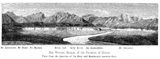
From the main sources of the river Rakaia to Mount Cook Range the Alps consist of one chain sending off divergent branches, which become gradually lower till they reach the Canterbury plains; but near Mount Holmes at the southern termination of the Mount Cook Range and its branch, called the Moorhouse range, an important change in their orographical structure occurs. The Southern Alps divide into two almost equal chains, of which the eastern one extends along the western bank of the river Hopkins to Mount Ward, whence it turns in a south-west by west direction towards Mount Brewster. The western chain commences also near Mount Holmes, losing near the sources of the Hopkins somewhat in altitude, but afterwards rises again to a great height, being formed by magnificent ranges, of which Mount Hooker and the Grey range are the most conspicuous. It runs in a south-west direction till it is broken through by the river Haast, after the junction of the Clarke, the broad valley of the latter occupying the space or basin between those two alpine chains. After this second break the Alps rise again, on the left side of that river, to a considerable altitude covered with vast fields of perpetual snow, both chains uniting at Mount Stuart, and running down in one longitudinal chain towards Mount Aspiring (lat. 44 deg. 25', long. 168 deg. 49') a mountain situated upon the frontier-line of the provinces Canterbury and Otago, and represented as a colossal cone of very regular shape, 9135 feet high.
It is a singular fact that the three principal peaks above named are all situated precisely in one and the same straight line, striking in the direction from E. 35 deg. N. to W. 35 deg. S. This line, passing towards Southwest over the Pembroke Peak (6710 feet) intersects
[Image of page 483]
the West Coast near Milford-Haven, at the point where the striking fiord-formation on the Southwest Coast of the Island commences. Towards Northeast it strikes the coast between Cape Campbell and Queen Charlotte-Sound on Cook's Strait, thus intersecting the South Island diagonally and forming the dividing line between the West and North Coast on one side and the East and South Coast on the other side.
The explorations of Dr. Haast at the head-waters of the Molyneux, the Waitaki, the Rangitata, and the Rakaia, and those of the Provincial Engineer Mr. E. Dobson in the upper valley of the Waimakariri, have fully established the fact that throughout the entire length of the Southern Alps in the province of Canterbury there are only three real passes, viz, the Hurunui Saddle, dividing the sources of the Hurunui and Teramakau; Haast's Pass at the head of Lake Wanaka, which leads over a very low saddle into the valley of the Haast river, which falls into the sea near Jackson's Bay; and Arthur's Pass, which is nothing more than a great fissure, running in a tolerably direct line from the valley of the Waimakariri to that of the Teramakau. The so-called North Rakaia Pass has no real claim to the title; its eastern face being simply a wall rising abruptly from the valley to a height of 1500 feet, and being at so great an elevation as to be buried deep in snow during eight months in the year.
This absence of passes throughout so great a distance can only be accounted for by the very peculiar structure of the central chain, as clearly explained by Mr. E. Dobson in his able report upon the Passes through the dividing range of the Canterbury Province. 7 The first point, says Mr. Dobson, to be noticed in regard to the central chain is, that it does not, as is popularly supposed, present an unbroken line of watershed, but rather a series of peaks and broken ridges separated from each other by deep ravines, and for the most part perfectly inaccessible. The clue to this
[Image of page 484]
system of ravines and ridges is to be found in the fact that the palaeozoic rocks forming the main range, have been at a very early period subjected to intensive pressure, the effect of which has been to crumple them up into huge folds, the upper portions of
[Legend of Map]
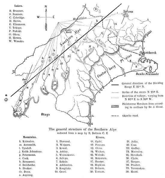
Lakes.
B. Brunner. S. Sumner. C. Coleridge. II. Heron. E. Ellesmere. T. Tekapo. P. Pukaki. 0. Ohau. H. Hawea. W. Wanaka.
General direction of the Dividing Range E 35 deg. N.
Strike of the strata N 22 deg. E.
Direction of valleys, varying from N 82 deg. E to S 30 deg. W.
Pleistocene Moraines from according to outlines by Dr. J. Haast.
Okarita road.
Mountains.
k. Kaimatau, as. Arrosmith. t. Tyndall, j. Keith Johnstone. p. Petermann. c. Cook. b. Beaumont. d. Delabeche. h. Hooker, da. Dana. a. Aspiring.
1. Hurunui. 2. Waipara. 3. Kowai. 4. Ashley. 5. Waimakariri. 6. Selvyn. 7. Rakaia. 8. Ashburton. 9. Rangitata. 10. Orari.
Rivers.
11. Opihi. 12. Pareora. 13. Otaio. 14. Waihao. 15. Waitaki. 16. Makarora. 17. Hunter. 18. Hopkins. 19. Dobson. 20. Tasman. 21. Jollie. 22. Cass. 23. Godley. 24. Macaulay. 25. Havelock. 26. Clyde. 27. Harper. 28. Poulter. 29. Teramakau. 30. Haast.
which have been removed leaving the remaining portions of the strata standing up on edge, either in a vertical position, or at very steep inclinations. The strike of the beds, corresponding with the
[Image of page 485]
direction of the axes of the foldings is tolerably regular, being generally about N. 22 deg. E. (true), thus differing from the general direction of the dividing range by 33 degrees. At the same time it is important to observe that the rule which has been found to prevail in other mountain chains of similar formation, appears to hold good also in the central chain, viz., that the greatest amount of denudation has taken place along the original ridges which are now occupied by valleys, whilst the existing peaks and ridges are on the sides of former depressions.
The next feature to be noticed is the jointed structure of the rocks. Although the joints cross each other in all directions, apparently without order, there are two prevailing systems of joints, which have an important influence on the configuration of the surface. These are: first, a system of vertical cross joints at right angles to the stratification and running in unbroken lines for great distances with such regularity that they might easily be mistaken for planes of stratification, were it not for the frequent occurence of beds of trap rock, the outcrop of which marks unmistakeably the true bedding; secondly, a system of joints more or less inclined to the horizon, not running in parallel planes but arranged in a series of curves radiating from a common centre.
The effect of this system of jointing combined with the strike of the beds or the direction of the axes of folding is to produce two distinct systems of valleys in the central chain, the direction of which is very remarkable. The one radiates from a common centre, situated about 50 miles North of Mount Darwin in the sea near Cliffy Head. This system includes all the principal valleys, from the Teramakau on the North to the Makarora on the South, their direction varying from N. 82 deg. E. to S. 30 deg. W., giving the idea that the country has been starred, just as a mirror is starred by a violent blow; or, as in rock blasting, a set of radiating fissures is sometimes produced, by a single shot. To the other system belong the valleys of rivers and watercourses running either on the strike of the beds or in the direction of the cross joints, or in a compound zigzag course, following alternately these two direc-
[Image of page 486]
tions, like a line struck diagonally across a chess board, but following the sides of the squares, and giving to the cliffs which bound these valleys a peculiar rectangular appearance, resembling ruined masonery on a gigantic scale.
With the exception of the Hurunui valley none of the radiating valleys runs directly across the main chain, which at the heads of the Rakaia and Waimakariri, stands up like a wall barring all further progress. Haast's Pass, the lowest, and probably the easiest of all, does not extend across the northern branch of the chain, but leads to the coast by following the westerly course of the Haast river. 8 Arthur's Pass does not, as it were, cross the range in a direct line as does that by the Hurunui, but leads along it from one radiating valley to another; the Waimakariri and the Teramakau overlapping each other to the extent of about 20 miles. Thus it will be understood that the three passes occur under three distinct sets of conditions. Haast's Pass, at the head of the Wanaka Lake, is both in the line of one of the great radiating valleys and also in the direction of the axis of the great foldings of the strata, these two causes in combination having formed an unusually low gap in the mountains. The Hurunui Pass, on the other hand, is one of the fractures running directly across the range, whilst Arthur's Pass 9 is a fissure parellel to the planes of stratification, from which the rock already bruised and shattered, when the surface of the country was crushed up into the huge foldings before referred to, has been gradually removed by glacial action and by the weathering process constantly going on over the whole face of nature.
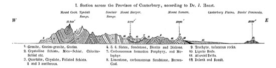
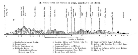
The general features of the Geology of the Southern Alps have been established by Dr. Haast's and Dr. Hector's researches in the provinces of Canterbury and Otago 10 and may be illustrated by the accompanying sections.
[Image of page 487]
[Image of page 488]
The formations are following from West to East pretty much in the natural sequence of their geological age; sections taken in this direction will, therefore, explain the geological structure most satisfactorily.
The western slope and part of the central chain consists of crystalline rocks and metamorphic schists, highly auriferous and resting upon a basis of granite, that presents itself here and there to the view in the rugged bluffs and declivities on the West coast. 11
[Image of page 489]
To the eastward of the crystalline zone, stratified sedimentary rocks appear, such as slates, sandstones, conglomerates, indurated shales interstratified with trappean rocks of a dioritic or diabasic nature. These compose by far the greater part of the eastern side of the central chain, exhibiting everywhere there huge foldings. This extensive formation of sandstones and slates in some places is overlaid uncomformably by a carbonaceous system. The relation of these sedimentary formations one to another, and their exact geological age, as compared with the European series of formations, has at yet not been distinctly made out. 12 The extensive development of limestones, such as are peculiar to the European Alps, is totally lacking; and a simple glance at the above sections shows farthermore, that only the eastern half of a complete mountain-system has been preserved, while the western half is buried in the depth of the main. The eastern foot of the mountains is formed by tertiary and alluvial deposits broken through by volcanic rocks. The period of volcanic energy was one of upheaval; and since it closed we see no evidence of there having been any submergence of the island on the East side, whilst on the West coast, the evidence derived from the mountains rising directly from the sea and penetrated by the fiords, indicates rather a gradual submergence. Another very remarkable feature of the magnificent snow clad range of the Southern Alps, is the enormous amount of glacier surface and glacier action, and moreover, the constant traces of those glaciers having at no remote period extended far below their
[Image of page 490]
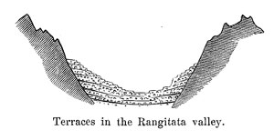
present limits. I shall here follow the footsteps of my friend Dr. Haast, who, in 1861, undertook the task of exploring the headwaters of the river Rangitata, and on that occasion first examined and described the beautiful glaciers of the New Zealand Alps. In ascending the Canterbury plains along the course of the Rangitata we reach near the gorge of the Rangitata the place, where the river enters the mountains, or, properly speaking, issues from the ranges and enters the plains by a deep rocky gorge about 260 feet deep. On the other side of the gorge the river-bed widens into a basin-like valley, several miles broad and about twenty miles long. The sides of the valley rise with steep walls, whilst the bottom is filled to a depth of more than 1000 feet with immense masses of boulders and sand, into which the river has excavated its
channel by terraces. The regularity and the great number of those terraces -- in some places as much as twenty-eight have been counted -- is truly astonishing; and in fact, no greater contrast can be conceived than the long horizontal lines of the terraces on the sides of the river-bed, their steps ascending the valleys with a gradient of 1 to 3 degress like broad, artificially laid out roads, and the broken outlines of the wild jagged rocky peaks above them. The river-bed itself has still, even here, the considerable breadth of one or two miles. The banks are covered partly with dense scrub, partly with Fagus forests, and partly with a growth of grass and with the "spear-grass" of the settlers (Aciphylla grandis Hook.). At the upper end of this deeply excavated valley, the terraces disappear gradually, and the river divides itself into two branches, the Havelock and the Clyde. At the junction of the Clyde with the Havelock, the bed of the river lies about 2200 feet above the level of the sea. The broad valley of the Rangitata is here divided into two narrow defiles running higher and higher to the flanks of mountains covered with perpetual snow and ice, and bear in
[Image of page 491]
their upper-parts the character of wild mountain gorges. The masses of debris filling these valleys take more and more the character of the ordinary mountain detritus, and are detached from the steep and precipitous mountain sides in the shape of sharp-edged fragments of rock, which are carried further along and rounded by the rushing waters of the river. The enormous mass of detritus in the mountains is truly astonishing. Haast says that mountain sides rising 5000 or 6000 feet above the valleys are often covered from their tops to the bottom with one unbroken talus of debris, so that not one projecting rock is to be seen. Avalanches, numerous watercourses, frequent rainfalls together with violent storms and frost, are, combined, the chief causes of this enormous denudation among the easily crumbling sandstones and slates. At altitudes above 3000 feet the temperature at night for at least six months in the year, is below the freezing point, while during the day it is so warm that generally a continued freezing and thawing takes place. The beds of the rivers have for a long course upwards a width of nearly a mile, but masses of detritus of every description, and gigantic blocks of rock (old moraines), which appear at times to shut up the whole valley, make it very difficult to proceed; even the vegetation assists in obstructing the way. He who has not seen the subalpine vegetation of New Zealand, writes Haast, can form no idea, how difficult it is to pass through it. The growth of scrub is in some places so dense, that it is necessary to walk literally on the top of it; the natural consequence being to break through, and then only releasing oneself with the greatest trouble and exertion. This occurs chiefly where the wind has bent the branches in one direction, giving them the appearance of clipped hedge rows. There is very indifferent feed for horses in these high alpine valleys; snowgrass and the leaves of the Celmesia coriacea, called "cotton plant" by the settlers, are often the only feed procurable.
Deep mountain ravines issue from the sides into the main valleys, and the higher the traveller ascends, the more grandly the great majestic character of this high mountain region becomes developed. From ten to fifteen miles from the already mentioned junction,
[Image of page 492]
both branches divide into numerous streams which spring from the glistening ice-portals of great valley glaciers (glaciers of the first order), plunging with deafening roar over a chaos of broken rocks, whilst high above, from the crest of the mountains, cascades fall down from the high-glaciers (glaciers of the second order), which hang like gigantic icicles from the vast snow fields; wild torrents are gushing, which like ribbons of silver, come down between the bare walls of rock, or spring from crag to crag in picturesque waterfalls, dissolving into spray and falling into the valley in the form of gentle rain.
Dr. Haast writes as follows about his first glacier journeys in those distant mountain regions: -- "On the 14 March (1861) I broke up camp in the Havelock valley and followed up the first stream coming in on the right, which I named after the distinguished English naturalist Forbes. I had to cross numerous mountain streams, which issuing from high glaciers plunged down the steep declivities of the mountains with a noise of thunder, and after a laborious scramble of several hours over the fallen rubbish and enormous blocks of rocks, I came at last in sight of the first valley glacier, which I named the Forbes glacier. At its lower end the breadth was 600 feet, and the height I estimated at 100 feet, consisting of well stratified masses of ice, the layers of a thickness from three to five feet, concave and apparently adopting the form of the valley. The ice itself was dirty, and the glacier completely covered with fragments of rocks, some of them of an astonishing size. From a glacial cave twenty feet high and equally wide, issued a discoloured glacial stream, which sought foaming and roaring for a course among the huge blocks of rocks, as they fell continually from the top of the terminal face of the glacier. I climbed in to the ice-grotto, where I found protection from the tumbling pieces of rocks and ice. A beautiful azure-blue twilight shone through the grotto; but the walls of ice were so loose that at a single blow from the hammer shattered large masses into a thousand pieces. But I was not allowed to stay there very long. Seeing that a part of the vault was giving way, I retreated,
[Image of page 493]
and being warned by the call of my companions, I had to stop behind a large rock, whilst an enormous fragment fell down into the river with a tremendous crash. The temperature of the water near its issue from the ice-portal was 32 deg. Fahr.; three miles lower down from the glacier it was already 39 deg. Fahr. By joint observations with my aneroid and the boiling water apparatus, I found the altitude of the glacier to be 3837 feet above the level of the sea. As far as I could see, the glacier was wholly covered with debris. The rocky cliffs on both sides of the glacier were about 500 feet high, almost vertical, and showed plainly streaked slips, a proof that the glacier must have been much higher in former times.
A few hundred yards below the origin of the Forbes a second glacier stream joins the former. There being no chance for me to cross the stream, I had to content myself with observing the second glacier, that gives rise to the latter stream, in the distance. It consisted of pure white ice; only a few blocks lay scattered over its surface. Extensive ice and snow-fields were looming up from the glacier to gigantic rock-pyramids. The uniform surface of the icefield appeared at the starting-point of the glacier fissured, and a grand ice-fall was to be observed, on which the glacier-ice was not only broken into the most differently shaped crags, needles, towers and walls, but also glistened in all shades from the brightest blue to the deepest green, few of the icicles appearing dyed in a deep pink. 13 The terminal face of this glacier lay about 200 feet higher than that of the former, and the shorter descent seems to be chiefly caused by the circumstance, that this glacier was not protected from the rays of the sun by piles of stones and rubbish like the other.
[Image of page 494]
It was with intense admiration that I gazed on the indescribably magnificent panorama before me. All around the patriarchs of the alps were enthroned, veiled in solemn, silver coverings of dazzling snow with venerable heads, whence flowed their long icy beards. Only the thunder of the avalanches, or the mournful cry of the large alpine parrot broke through the stillness of virgin nature. A deep feeling of veneration and holy overcame me, when I reflected that on the spot where I stood in the solitary wilderness, human foot had never pressed before."
The exploration of the Havelock valley was followed by an exploration of the second branch of the Rangitata, the Clyde. The first tributary from the left, or from North, was named Lawrence. It springs from Mt. Arrowsmith, a mountain-colossus about 10,000 feet high, from the slopes of which huge glaciers descend in all directions. Like the Lawrence so also the other tributaries of the Clyde, St. Clair-Creek, and M'Coy Creek, are glacier streams. Following the main valley to its upper end Dr. Haast discovered the principal glacier descending from Mt. Tyndall, 14 which he named the Great Clyde glacier. The end of this glacier is 3762 feet above the sea; it forms an ice-wall 1300 feet broad and 120 feet high. The river springs from a large glacial cave; and above the cave, about twenty feet below the surface of the glacier, a second stream issued forth from a round hole as from the gutter of a house. The glacier was entirely covered with stones, so that the ice was scarcely visible on the surface.
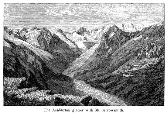
The third region of glaciers, which Dr. Haast visited, was that of the Ashburton river. The Ashburton glacier lies at the eastern foot of Mt. Arrowsmith. It descends to a height of 4823 feet, and at its terminal face is only 300 feet broad, and 30 to 40 feet high. It pushes a large moraine ahead of it, and appears very remarkable by its clean surface, which bears no stones whatever, as well as by the clear stratification of its ice. Its inclination near the terminal face amounts to 7 or 8 degrees; farther up the valley an ice-fall is to
[Image of page 495]
be seen, from which the ice, traversed by deep fissures and clefts, ascends in terraces up to the snow-fields. Great portions of this glacier having melted off on the sides of the valley, even its lower surface could be seen resting upon large rounded boulders as upon rollers, so that it was possible to creep between the larger boulders
under the glacier. The commencement of winter put an end to Dr. Haast's investigations. Till end of May, my friend wrote to me, the weather was delightful, despite the very cold nights, in which the thermometer fell as low as 24 deg. Fahr., but now winter set in with fogs, rain and snow; it was time to retire to the lower regions; but it was most reluctantly that I parted from that grand nature and from the majestic scenery of the Southern Alps. 15
[Image of page 496]
Still grander glacier-regions has Dr. Haast discovered in the summer of 1862 at the headwaters of the Waitaki river on Mount Cook and on the neighbouring gigantic heights of the Alps. The Waitaki (or Waitangi), one of the principal rivers of the East coast, is formed by three branches, springing from three mountain-lakes on the S.E. foot of Mount Cook, the Tekapo, Pukaki and Ohau. Lake Tekapo lies 2468 foot above the level of the sea; it measures 15 miles in length and about 3 miles in breadth. The water of the lake is turbid of a milky colour and it is only after months of cold and dry weather, that the water becomes somewhat clearer. The difference between high and low water amounts to 8 feet. The lake abounds in large eels, which, however, disappear in the month of April with the setting in of winter, and do not reappear until October. It is plainly visible that the lake is filling up rapidly, as the river deltas are extending far into the lake. The shore on the lower end of the lake seems to have been formed by the colossal moraine of an old glacier, through which the outlet of the lake gradually forced its way. The principal tributary of the lake from the North was called Godley, the northeastern one the Cass. 16 Both spring from large glaciers descending from the mountains North of Mount Cook, the Godley from the great Godley glacier and the Classen glacier, the Cass from two glaciers situated about 20 miles from the lake on the slopes of Mount Darwin. The great Godley glacier -- at its terminal face one and a quarter of a mile in breadth, but farther up, where it receives the Grey glacier about three miles broad -- may be designated as the "Mer de Glace" of New Zealand. The view from its middle moraine upon the ice-and snow-fields 17 of Mount Tyndall, Mount Petermann, and the Keith-Johnston range Dr. Haast pictures as the grandest scenery he ever beheld in the Alps.
Lake Pukaki, measuring 10 miles in length and 4 miles in
[Image of page 497]
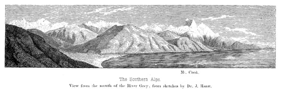
breadth, has an elevation of 1717 feet above the sea, 18 its water likewise being milky-turbid. It is shut in by an old terminal moraine attaining a height of 186 feet above the lake. The view from the outlet of the lake towards the Southern Alps with Mount Cook in the centre and a wooded islet in the foreground is described as sublime in the extreme, and when we imagine villas and parks around its shores, the Lago di Como or Lago Maggiore would not bear comparison with it. The main-tributary from the North is the Tasman river, a sluggish stream, separated into numerous branches -- Dr. Haast in one place counted 34 of them -- and flowing through a broad valley, which is noted for swamps and dangerous tracts of quick-sand. This valley leads to one of the most extensive glacier-regions of the Alps.
Five large glaciers extend from the slopes of Mount Cook and of the adjoining peaks, -- which Dr. Haast has designated by the names of Mount Haidinger, Mount de la Beche, Mount Elie de Beaumont and Mount Darwin, -- in a southerly and southeasterly direction far down into the valleys. The Great Tasman glacier, the main source of the river Tasman, of a length of 18 miles, and a breadth of nearly two miles at its terminal face is the largest glacier hitherto observed in New Zealand. 19 For a distance of three miles upward this glacier is entirely covered with an enormous load of debris, so that the ice is only now and then visible in transverse and longitudinal crevasses and in large holes 100 to 150 feet deep. About nine miles up the valley it receives from a western side-valley a glacier one mile broad, which descends in two arms from the slopes of Mount Cook, Mount Tasman and Mount Haidinger, and which my friend Haast was pleased to designate after my name -- Hochstetter glacier. The streams from the Tasman glacier flow on both sides of the glacier. The Murchison glacier,
[Image of page 498]
East of the Tasman glacier, brings the ice masses down from Mount Darwin and Mount Malte Brun. The river streaming from it issues from a glacial-cave on the extreme East-side of the glacier. The Hooker glacier comes in two branches from the southern foot of Mount Cook; whilst the ice masses of the Mueller glacier descend from Mount Sefton and the Moorhouse range. 20 Near the head of this glacier is a pass over a wall, formed of nearly perpendicular rocks about 100 feet above the glacier, which would bring us upon the Selwyn glacier, forming one of the sources of the River Dobson, falling into Lake Ohau (or Ohou). 21 About a quarter of a mile down the Dobson river valley another glacier, of a very peculiar formation, comes down the principal peak of the Naumann range, which runs from the Moorhouse range between the two main branches of the Hopkins river to their junction. Owing to the great steepness of the mountain sides, a large portion of the ice is pushed before it can melt, at many spots over the perpendicular ledges, and falling down with a tremendous crash, is again cemented together to expand to a new glacier; at the same time a narrow channel between the upper and lower glaciers brings down the remains of the upper ice masses, which have escaped being thrown over. Dr. Haast named this glacier the Hourglass glacier, from its peculiar form. The elevation of its terminal face is 3816 feet.
What an impassable wall of ice and rock the Southern Alps proper present, is still more apparent at the West Coast, where also glaciers scarcely less inferior in size to their eastern neighbours descend towards the West Coast plains. It is there where the existence of a glacier is stated, the terminal face of which lies only 705 feet above the sea, with a rich and varied vegetation close to
[Inserted page]
[Legend]
View from the Waiau River, West Coast.
View from Lake Ohau.
Printed by F. Koke, Vienna
[Image of page 499]
it, and is was again Dr. Haast, who during- a journey along the West Coast between Hokitika and the Waiau river, in 1865, has discovered that very remarkable glacier and named it Francis Joseph glacier in honor of His Majesty the Emperor of Austria and in remembrance to the Novara Expedition, which had been sent out by His Majesty. 22 The Francis Joseph glacier comes down from
[Image of page 500]
the snow-fields of Mount Tasman, Mount Haidinger and Mount de la Beche and feeds the Waiau river. The position of the glacier
[Image of page 501]
is about lat. 43 deg. 35 min. S, long. 170 deg. 12' E. of Gr., corresponding in the northern hemisphere with that of Montpellier, Pau and Marseilles in France, and Leghorn in Italy, where already the orange and lemon tree, the vine and the fig tree, are covered with juicy fruits, and where palm trees raise their graceful crown into the balmy air. Even in the European Alps, which lie some degrees further north, the average altitude of the terminal face of the larger glaciers is about 4000 feet, whilst we have to go twenty degrees more to the north, till we find, in Norway, glaciers descend to the same low position, and to about 67 deg. north, before the terminal face reaches the sea. Thus, we see, that the glaciers of New Zealand in proportion to the heights of the mountains are much larger, than the glaciers of the European Alps.
We may, therefore, justly ask for the reasons of the enormous size of the glaciers in the Southern Alps, considering the narrowness of the central chain, and for the causes to which we must attribute the remarkable occurrence of a glacier in such a low position, as the Francis Joseph glacier on the West Coast. We may best explain that by regarding the equal and humid oceanic climate of New Zealand, and the great difference of the climate on the two coasts. From the first explorer, who ever set his foot on the West Coast, to the discovery of the gold-fields, the difference of rainfall on the two coasts has always been a topic of great interest. While on the East-side the country was languishing for rain, on the other side the exploring parties suffered day after day from deluging rain and heavy mists. Fortunately we have now some data to go upon to determine that difference more accurately. According to the very valuable observations of Mr. J. Rochfort 23 during
[Image of page 502]
the period from the month of May to end of December 1865 the rainfall at the West Coast was more than five times as great as at the East Coast, amounting at Hokitika to 96,136 inches, and at Christchurch only 17,395. In the southwestern part of the island Dr. Hector, in 1863, during a period of seven months from the first of June to end of December had observed 87 inches, whilst in Dunedin the rainfall was only 23 1/4 inches. Thus, it is obvious, as the perpetual snow-line, owing to the equable and humid climate, is at the West Coast very low, probably about 6500 feet near Mount Cook, and as the fall of snow and condensation of moisture must still be greater in those higher regions, where the equatorial currents come in contact with the cold surfaces of the Alps, that all necessary conditions exist not only for the formation of large glaciers, but also for their descent to much lower regions than at the East Coast, where the line of perpetual snow in a latitude from 43 to 44 degrees probably only reaches 7500 feet. The difference between the eastern and western side of the central chain is well exhibited by the great Tasman glacier, which, although of much larger dimensions than the Francis Joseph glacier, yet descends only to 2774 feet above the sea-level, whilst the latter reaches more than 2000 feet lower, namely to 705 feet above the sea. It is true that particular circumstances, as, for instance, a large cauldron-like basin, sheltered from the sun's rays by Mount de la Beche and its out-running spurs, in which these enormous snow-masses can accumulate, are very favourable for allowing the glaciers to descend to such a low position above the sea level, where arborescent ferns, pines, and other low-land trees are growing. But if we compare its position with others in South America, we shall find that, from ranges which are not so elevated as the Southern Alps, even in latitudes corresponding with the northern end of Stewart's Is-
[Image of page 503]
land, enormous glaciers descend in latitude 40 degrees 50 minutes, according to Darwin, to the level of the sea, their terminal face being ultimately washed away and carried along as huge icebergs. Thus the conditions for the lowering of the snow-line and of the excess of moisture must still be greater in that part of America than in New Zealand, where the neighbourhood of Australia and Tasmania will certainly exorcise some moderating influence, which in Terra del Fuego does not exist. From observations made in those and other regions, it is clear that the lowering of the snowline does not depend on the mean temperature of the year, but on the low temperature of the summer. 24
Although, as we have seen, the size of the principal glaciers in the Southern Alps is enormous, considering the height and narrowness of the central chain, the astonishment of the geological observer increases on meeting every where the signs of a still more considerable glaciation during former periods. There are perhaps, as Dr. Haast states, nowhere in the well-known regions of the earth so easy of access, and in such comparatively low positions above the level of the sea, such clear and fresh signs of the existence of enormous glaciers during the pleistocene epoch, than upon the Southern Island of New Zealand. Far below the moraines at the terminal face of the present glaciers old moraines are met with, striking across valleys several miles broad and overgrown with a dense subalpine vegetation, which is nearly impenetrable to horse and man. Combined with them the strait courses, the great depth and breadth of the valleys, which are in no proportion to the rivers now running through them, and the rounded outlines of the lower mountains (roches moutonnees) are unmistakable indications, that the
[Image of page 504]
valleys have been excavated by glacier-action, and that glaciers of great dimensions had filled them and polished their sides. 25 On the western coast the valleys have been scooped out to a depth which is now at least 1800 feet, in some cases, beneath the present sea-level, 26 while on the East-side, where the depression of the land has not been so great, these valleys are occupied by lakes, the surfaces of which have a mean altitude of 1000 to 2000 feet, but the bottoms of which are partly considerably below the sea-level. The borders of those lakes are formed by the enormous lateral and frontal moraines of glaciers of earlier date, while the lateral moraines are now represented as fringing shelves along the sides of the valleys, just like the terraces skirting the valley of a river, which is changing its course from side to side of a gradually deepening channel.
In inquiring into the causes of the pleistocene glaciation of the
[Image of page 505]
South Island we need not resort to the hypothesis of a general ice-period caused by cosmical influences, and which was supposed to have covered the surface of the globe from the poles to the torrid zone with snow and ice, but find the must reasonable explanation in physical causes now in existence, if we only suppose, that the Southern Alps during the pleistocene period differed somewhat from their present features, forming higher and more plateau-like ranges, while the climatical influences as well as the action of water and ice at that period were the same as at present. My views in this respect are perfectly in accordance with the views advocated by my friend Dr. Haast. 27
From the extensive tertiary strata, covering large areas upon the South Island even to an elevation of more than 2000 feet we may infer, that during the tertiary period the South Island was to a great extent submerged below the level of the sea. The country emerging again the physical feature was a high, plateau-like mountain mass, but with depressions existing before the tertiary submergence -- now partly obliterated. After the mountains had risen above the line of perpetual snow, the accumulation of snow and ice fields (neves) began. It would be however a mistake, to estimate the size of glaciers generated merely by the altitude of the mountain region, as it is truly the area which in the districts is elevated above the snow-line together with the climate, that determines their extent. The neves, considering the insular position and the oceanic climate of New Zealand -- its principal backbone running from S.W. to N.E., thus lying at a right angle to the prevailing air currents, the equatorial north-west and the polar southeast, both bringing moisture with them -- must soon have attained an enormous extent, even had the land not been raised, at it is probable, to a higher elevation than at present. The consequence was, that glaciers were formed descending down the natural out-
[Image of page 506]
lets and grinding down the rugosities of bottom and sides. Thus the scooping and ridge making action of ice and water began. If this be the case, the area of the snow-fields, as the mountains began to become more and more eaten into by the eroding action of the descending ice and the wearing away of the heights by atmospheric influences and sharp ridges and peaks were more and more formed, must have been rapidly diminishing; and in the same measure as the valleys were scooped out, the glaciers must have retreated from the coast towards the centre of the mountains and their extent diminished. Thus we have the most simple and natural explanation for the fact, that the glaciers of New Zealand since the pleistocene period have been more and more retreating into the deep alpine valleys to their present limits: and we need not suppose, that the pleistocene glaciers, although generally larger than the present ones, attained such an enormous length, as the distance of their terminal moraines seems to indicate. Judging, however, from the structure of the Sounds on the West-side of the mountains, and that of the Lake districts on the East-side, it seems probable that the opposite sides of the mountain range have besides undergone repeated and alternate oscillations to the extent of at least 1000 feet in either direction from a nominal point; and that the western district being at present near to the period of greatest depression the re-elevation of the land to the other extreme would be also sufficient to extend again the glaciers to farther limits.
From the present features of the New Zealand Alps we can easily imagine what enormous masses of rock must have been destroyed in course of time by the combined action of atmospheric influences, of ice and of water. We need only look upon the immense extent of drift, partly glacial, and partly alluvial throughout the Alps, and as far as the borders of the sea, to know what has become of them. The rocks desintegrated into boulders shingle sand and mud, and the colossal moraines of the glaciers have furnished the material for the drift-formation, which on the foot of the mountains forms extensive plains, filling the valleys up to a height of more than 1000 feet, and which extends from valley to valley across
[Image of page 507]
the mountain-passes, reaching sometimes the height of 5000 feet, thus enabling the traveller to proceed from range to range, from valley to valley, without once setting foot upon the native rock. The most prominent example of drift-formation, formed partly by the accumulations of the old pleistocene glaciers, partly by the deposits of the torrents falling from the ranges to the sea, are the Canterbury Plains, the formation of which has been so clearly shown by the combined labours and investigations of Messrs. Haast, E. Dobson, Beetham, Doyne, and several others. 28 In concluding the chapter of the Southern Alps, I may be allowed to dwell upon those plains, which, by their position, nature and general characteristics, form such a prominent feature upon the South Island.
The Canterbury Plains extend from Double Corner, South of the mouth of the Hurunui to the dolerite plateau of Timaru. Their length from N.E. to S.W. is 112 miles. Their breadth from a few miles at both extremities, North and South, augments as we advance towards their centre, having their greatest lateral extension near Banks' Peninsula, where in a direction from East to West they stretch a distance of more than fifty miles to the base of the mountains. A long uninterrupted shore-line, called the Ninety miles Beach, streches from Timaru towards the volcanic system of Banks' Peninsula which rises so conspicuously from that low shore, and to the existence of which a great portion of the loose strata composing the plains owe mainly their preservation from the destructive agencies of the waves and currents. The plains rise from the East Coast towards the mountains, reaching at the foot of the hills a height of 1500 feet. A general section, taken in a direct line from the sea to the hills may be described as a curved line, differing but little from dead level near the coast, but rising at a gradually increasing gradient until it reaches the hills, which, in most places, rise abruptly from the plains. The material as found upon the surface of the plains, and for a depth, as proved by wells sunk
[Image of page 508]
of nearly 200 feet below it, from a few miles within the coast line to the foot of the hills, is altogether composed of hard grey shingle and gravel filled up with variable proportions of sand and fine silicious silt. It is usually quite permeable to water; but nearer the sea, where the finer mud has been deposited in lagoons, deep beeds of impermeable soil are found. Nowhere over the whole extent of the plains has a trace of marine deposit been discovered.
The plains are intersected by numerous rivers, which the settlers divide into three classes: snow rivers, rain rivers and leakage rivers. The snow rivers, to which the Waimakariri, Rakaia, Ashburton and Rangitata belong, have their sources in the central chain. They are wild torrents issuing from the deep rock-bound gorges of the Alps, fed by the glaciers and melting snows, and are consequently subject to sudden and powerful freshes. They never dry during the autumn or summer months. The so-called rain rivers are those which have their origin in the outrunning spurs of the Alps, as, for example the Selwyn, Hinds, Ashley and others. One of their characteristic features is, that they generally dry up during the summer and autumn months, that to say, that they disappear in their course below the shingle, of which the plains are composed. The leakage rivers consist of those smaller water-courses which take their rise on the plains themselves, as for instance the Heathcote, Avon, Styx, Little Rakaia and many others. They are merely formed by the waters of the rivers of the former two classes, which, losing themselves among the shingle till they find impermeable beds to arrest their further sinking, and on which they flow downwards, form underground streams till forced to the surface by meeting a change of the strata. The water flowing from each of these outlets is remarkably uniform throughout the year, and is always beautifully clear. 29
[Image of page 509]
The snow rivers are those, by the action of which the surface of the plains has derived its present form. In their passage through the mountains they carry with them the desintegrated materials they meet with. These are of every variety of size, from impalpable mud to large boulders; they are deposited along the beds of the streams, the heaviest particles highest up and the remainder over the whole length to the sea. Thus the beds of the streams become built up to, and above the level of the already illdefined banks; the waters leave the old courses and cut out new ones; these they rapidly widen till the water spreads and rambles over miles in width, and again deposits the materials brought down. Each stream thus roams over a large area, its various courses radiating from a centre at or near the gorge through which it debouches on the plains. It builds up, by layer on layer, that portion of the plain which it is destined to work over, and is ever thus travelling from north to south, and south to north, over a distance averaging about forty miles. It thus leaves within its field of operations a nearly level surface, slightly corrugated in lines radiating from a centre, and closely resembling a lady's fan, by which name it has been most appropriately designated in Dr. Haast's report. This operation has been in action since the pleistocene period, and no doubt, the present rivers repeat simply on a smaller scale the action of the large pleistocene torrents which formed the upper part of the plains. The present rivers have, in consequence, according to their present size and position of sources cut more or less deeply into the old fans at the foot of the mountains, whilst they raise their beds at a greater distance from the mountains and forme there the new fans near the sea coast. Thus, the river beds themselves rise from the sea to the mountain gorges at a tolerably regular slope of from 20 to 30 feet per mile; running from the gorges between terraces of great height, which gradually diminish until they die away altogether, leaving the rivers to run on the surface of the plains for a short space, after which they begin, instead
[Image of page 510]
of excavating to fill up and raise their beds, and run to the sea upon elevated dams, similar to the Po and the Adige in Upper-Italy, and between high cliffs of shingle, whose height varies with that to which the edge of the plains rises above the sea beach. With few exceptions, therefore, every one of these rivers presents a point at which it may be crossed on the general level of the country, below which it is either inaccessible on account of the cliffs by which it is bounded, or difficult to cross on account of the number and depth of the channels into which it spreads on the surface of the plains, and above which it can only be approached by long sidling descents cut in the terraces. 30
Such are the laws which guide these rivers, by the action of which extensive and fertile plains have been formed at the foot of an inhospitable mountain range. These plains, which will one day be the centre of a rich, industrious and large population, are now the home of an energetic and high minded class of settlers, in the name of which Mr. Dobson, the Vice-President of the Philosophical Institute of Canterbury at the annual meeting on November 5, 1866, could indeed proudly say: "With scanty means, and a comparatively small population, we have succeeded in introducing amongst us most of the great inventions of the civilised world. We have our telegraph through the country, and our submarine
[Image of page 511]
cable connecting our capital with the seat of Government in the Northern Island. We have our great tunnel in construction, and our road across the New Zealand Alps. We have our goldfields, our coal mines, our founderies, our broad acres tilled with the steam plough, our clipper steamers, our mail coaches, and our locomotive railways, and we have all this in a country which, fifteen years ago, was an almost unknown land, but which is now, by God's blessing, the happy home of prosperous thousands of our fellow men."
Appendix: The Otira or Arthur's Pass road, the first road across the Southern Alps.
Appendix.
The Otira or Arthur's Pass road, the first road across the Southern Alps.
31 Amongst the public works of the Province of Canterbury stands prominent the new road, just constructed, by the gorge of the Otira, across the New Zealand Alps, connecting the City of Christchurch with Hokitika and Greymouth, the ports of the western goldfields. The Otira road is a remarkable work, in every point of view; whether we consider the grandeur of the scenery through which it passes, the geological interest of the Alpine districts which it traverses, the engineering difficulties attendant on its con-
[Image of page 512]
struction, or the hardships manfully endured by those engaged on the undertaking, it is in every way a work reflecting credit, not only on the Canterbury province, but on all New Zealand.
Up to the commencement of the year 1865, there was no road from the Canterbury plains to the West Coast, except a very rough and dangerous path, cut across the Hurunui saddle by Mr. Charlton Howitt, in 1862, by means of which, at considerable risk, horses could be taken as far as Lake Brunner. Mr. Howitt was engaged at the time of its death, in 1863, in cutting a track from Lake Brunner to the mouth of the Greenstone Creek, but it was not practicable for horses. Up to the date last mentioned, but little attention had been paid to the fact that, notwithstanding the inaccessible nature of the country, a very large number of diggers had found their way into Westland, and were pursuing their vocation with considerable success. About the beginning of 1865, however, the reports sent by the miners to their friends were of such a favourable character, that a violent rush set in from Eastland to the new El Dorado, and the attention of the Government was directed to the best method of opening up a communication with the goldfields. To this end Messrs. Edwin and Walter Blake were sent to improve Howitt's track by the Hurunui and Teramakau to Lake Brunner, and to explore for a line of road in continuation across the country between the Teramakau and Hokitika. At the same time, Mr. George Dobson and the Provincial Engineer were charged with the examination of the Waimakariri and its tributaries, to ascertain whether there were any passes which might afford greater facilities for constructing a road across the Alps than that by the Hurunui saddle. The results of these explorations were published in a report from the Provincial Engineer, dated May 15, 1865, amply illustrated with maps and sections.
In accordance with the recommendations of this report the Government at once took steeps for the construction of a bridle road over Arthur's Pass, descending into the Teramakau by the gorge of the Otira. It was at first intended to construct a mere bridle track, but the importance of the new goldfields developed itself so rapidly, that within a few weeks of the commencement of the works it was decided to construct a coach road throughout. From the date of this decision the works along the whole line of road from the plains to the sea beach were put in hand as rapidly as possible, and pushed forward with such energy, that by the 20th of March, 1866, the road was open for traffic from end to end. and has been regularly travelled ever since by four-horse coaches running twice weekly each way; the distance of 150 miles between Christchurch and Hokitika, being completed in 36 hours, including a night stoppage of 12 hours at the halfway station.
[Image of page 513]
It is very difficult by a verbal description to give any idea of the obstacles that presented themselves to the construction of this road. Perhaps the greatest of all arose from the inaccessible character of the country; the only way of getting tools and stores to the central portion of the work being either by pulling canoes up the Teramakau from the beach, or by pack-horses travelling over the Hurunui saddle, from the edge of the plains -- a journey of seventy miles, and, moreover, this had to be done in a densely timbered country, in the depth of the winter.
No pen can describe the sufferings endured by both man and beast, during that terrible winter, exposed to sleet and snow and bitter frost, hardly lodged and scantily fed, whilst the working parties were liable at any moment to be cut off from communication with each other by the rising of the rivers. By the end of July, however, a pack-horse track was opened through the Otira Gorge, which enabled supplies to be taken into the Teramakau valley with comparative ease, and the works in the latter valley were greatly facilitated by the use of drays, which were carried in pieces across Arthur's Pass, and put together in the Teramakau river bed which was used as a temporary road whilst the bush clearings were being made. As with the opening of the tracks greater facilities were given for the conveyance of stores to the works, the number of men employed was increased, until it amounted to upwards of a thousand.
Since the opening of the road the work has gone steadily on, and may now be said to be completed, although, from the nature of the country through which it passes, it will always require constant attention to keep it in repair, especially in the valley of the Teramakau, which is periodically visited by dangerous floods.
The total distance from Christchurch to Hokitika, by the Otira route, is 150 miles as above stated, of which about one hundred miles of road from the eastern foot of the hills to the sea beach at the mouth of the Arahura have been made and metalled between May 1st, 1865, and October 31st, 1866, at coast, in round numbers, of £145,000, or something under £1,500 per mile.
The engineering works upon this line are of a very varied nature. In some places the cliffs are scarfed out for a portion of the width of the road, the remainder being carried on timber brackets in the fashion of Trajan's celebrated road on the bank of the Danube; in others, the line is carried across ravines on embankments faced with walls made of timber cribbing, filled with blocks of stone.
The fords in the rivers have been protected by wing dams formed of large trees, backed with boulders; whilst in many places the mountain tor-
[Image of page 514]
rents have been made passable by building timber weirs across them, and filling up their beds to a uniform level with stones and gravel. Through the swampy forest the ground has been drained and fascined for many miles, whilst the whole length of the road has been thoroughly metalled. Amongst the bridges, that over the Taipo, 270 feet long, built upon pies with steel shoes, driven into a mass of granite boulders, deserves mention, as being a difficult work successfully executed, and which has, up to the present time, resisted the heaviest floods, although the stream has been at times blocked with drift timber from bank to bank.
Altitudes along the Arthur's Pass road.
Cook's Accommodation House.............. 217
White's Accommodation House.............. 623
Southern base of Little Race Course Hill.......... 995
M'Cray's Accommodation House.............. 1327
Riddle's Accommodation House, foot of Porter's Pass...... 2091
Summit of Porter's Pass................ 3234
Lake Lyndon.................... 2814
Watershed between Lake Lyndon and River Porter...... 2852
Springs, sources of River Porter............. 2609
Riverbed of River Porter, crossing of road......... 2270
Summit of terrace on its western side........... 2473
Stables of Cobb and Co., near Mr. Enys's station....... 2548
Top of terrace of Broken river.............. 2413
Bed of Broken river, where crossed by road......... 2168
Top of Cragieburn saddle................ 2843
Cragieburn Accommodation House............. 2221
Lake Pearson.................... 2095
Roches moutounees, near River Cass and Lake Grasmere, eastern base 2157
Road crossing of River Cass............... 1879
Saddle between the Cass crossing and the River Waimakariri... 1938
Bed of Waimakariri between the two cuttings........ 1863
Bealey Township, Police reserve............. 2155
Southern foot of Arthur's Pass (Mr. Smith's camp)....... 2534
Arthur's Pass, highest summit.............. 3038
Southern foot of Moraine................ 2697
Summit of Moraine.................. 2865
Mr. Wright's camp.................. 2238
Riverbed of Otira, near first bridge............ 2026
Junction of the two branches of the Otira near the stockyard... 1449
[Image of page 515]
Bed of Teramakau river, near junction of the Otira where the road joins the former................. 769
Western bank of River Taipo, near the junction of the Teramakau... 356
Waimea, where the road leaves the Teramakau........ 148
Foot of terrace between the Rivers Teramakau and Kawhaka... 121
First terrace.................... 292
Summit of highest terrace ............... 647
M'Clintock's store, near Kawhaka Creek.......... 410
Junction of Kawhaka with Arahura............ 145