CHAPTER II. PHYSICAL GEOGRAPHY.
[Image of page 70]
CHAPTER II.
PHYSICAL GEOGRAPHY.
FROM the entrance of Blind Bay, the mountain chains by which it is enclosed may be distinctly traced as they stretch towards the south. That on its western side is continuous for a considerable distance, rising at Separation Point, and running thence southward towards the western extremity of Mount Murchison, where it appears to terminate abruptly. On the eastern side of the bay, over the low hills which surround the city of Nelson, are seen the high mountains named Ben Nevis and Gordon's Knob, forming part of a chain beginning near Queen Charlotte Sound, and running thence to the Spencer mountains. Between these two ranges an undulating table land is visible, apparently of little height, which stretches in a south-westerly direction to the base of Mount Murchison. On ascending the last-named mountain, an opening between the eastern and western chains becomes visible, extending as far as the eye can reach in a south-south-westerly direction. At a distance of seventy-five miles in a straight line from the city of Nelson, this opening or fissure, on each side of which the above-named ranges have been upheaved, and which up to that point maintains an average breadth of eight to ten miles, narrows, and the mountain chains reach their greatest altitude. Their spurs run into each other, almost uniting their rugged masses, and forming for eight miles a succession of narrow gorges, through which several rivers flow. The mountains then again recede from each other, the eastern chain running in a southerly direction, and the western turning southwest towards the West Coast, whilst the lower land between widens to a considerable extent.
In the northern part of this remarkable fissure, the lakes which occur are found at the foot of the eastern chain, whilst on its southern sides lakes are found (in the Province of Canterbury) lying at the foot of the western range, thus indicating the natural watershed of the island.
But this is not the only fissure by which the northern part of this island is divided; another large opening cuts in a transverse direction through the two mountain systems above described,
[Image of page 71]
running east by north and west by south, and intersecting the longitudinal fissure near Mount Murchison. A few miles to the north of Lake Roto-iti the eastern chain is broken through, and a pass of little elevation leads into the valley of the Wainui, the course of which from this point can be traced almost to the sea. The western chain is in like manner broken through by the Buller river, whose course can also be followed by the eye to its mouth on the West Coast.
The longitudinal fissure above mentioned has an average altitude of 2,000 to 2,500 feet above the level of the sea, and exhibits a hilly plateau, on which, near the eastern chain, several regular conical and dome-shaped mountains rise to an altitude of 3,500 to 4,000 feet above the sea level. This plateau is moreover intersected by streams which run in deep gullies, and, with the exception of some grassy terraces and open patches on the banks of these rivers, is densely covered with forest. The openings through which the Wairau and the Buller flow are merely the valleys of rivers, narrowing where they receive no tributaries, to mere gorges, and breaking in a transverse direction through high mountain ranges.
As I began my exploration at Lake Roto-iti, I shall adopt it as my starting point in describing the physical character of the eastern lateral chain, at the same time connecting with it the description of the sources of the Buller and its tributaries. This eastern chain attains its greatest elevation (rising abruptly on the eastern side of the longitudinal fissure) in the Spencer mountains, whose peaks attain an altitude of at least 10,000 feet, and are covered with perpetual snow. Three of these peaks are very conspicuous; the central one, named by me Mount Franklin, lies in latitude 42 deg. 1 min. South, and longitude 172 deg. 37 min. East. From this, as a centre, the various ranges branch off to the northward and southward. I found, upon a careful examination, that the main ranges below the above-mentioned peaks are 8,000 feet, and the ranges which branch from them 6,500 feet high. These ranges are covered, to an altitude of 4,000 to 4,500 feet, with dense forest, above which an Alpine vegetation begins, and the summits form meadows of short smooth snow-grass, the whole reminding me greatly of the wild Alpine scenery of Switzerland.
The most easterly of the branching ranges which came within the limit of my researches, was the St. Arnaud range, so named by Mr. Travers when he passed through the gorge of the Wairau in 1854, and lies on the western side of that river, forming, until it reaches the Top-house, the watershed between the east and west coasts. This chain, beginning on the southern side of the old pass from Nelson to the Wairau, soon rises to an altitude of 6,500 feet, its western base forming the eastern shore of the beautiful Alpine Lake Roto-iti. On the south-western side of this splendid water basin, a second range begins, forming, above
[Image of page 72]
the lake, a small plateau 4,700 feet high, from which afterwards this mountain rises to an altitude of 6,200 feet.
This second chain I have named the middle range. These two ranges appear to unite about six miles south of the southern extremity of Lake Roto-iti, and form a high serrated nucleus of peaks from 7,000 to 7,500 feet high, which I named Mount Travers, after my energetic friend Mr. W. T. L. Travers, who has done so much towards our knowledge of this hitherto unknown region. It is in this range that we have to look for the principal feeders, and, considering the distance from its mouth, for the actual sources of the Kawatiri, or Buller. Out of the southern extremity of the valley formed by these two ranges, flows the principal feeder of the Roto-iti lake, meandering, as I observed from Mount Robert, which lies above it, for a few miles through a picturesque valley, and then lost in a frightful mountain gorge. The sources of this river are sixty-three miles in a straight line from the mouth of the Buller.
On the western side of Mount Travers we meet the sources of the Pukawini, or Howard river, which falls into the Roto-iti river about nine miles below the lake. The united ranges then stretch towards the south, and form, above Lake Roto-roa, a conspicuous dome-shaped mountain mass, 7,500 feet high, which I named Mount Mackay, after Mr. James Mackay, who was my companion whilst exploring this part of the country. Here the chain falls abruptly, and a large valley appears, through which flows one of the principal feeders of the lake, having its source near that of the Waiau-ua, on the eastern side of the Spencer mountains, whilst another streams joins it, flowing in the southerly direction from Mount Travers to the eastward of Mount Mackay.
The Maories, in travelling in former years from the Port Cooper plains towards Wakatu (Nelson), used this pass, and describe it as easy, and as possessing a gradual and uniform gradient. Here, therefore, we have a lateral break in the chains, dividing their northern parts from the Spencer mountains proper. Lake Roto-roa lying more to the westward, and 258 feet lower than Lake Roto-iti, has, besides the first-mentioned feeder, which I called the Sabine, the course of which is north-north-west, another important one, which I named the D'Urville, running through a deep gorge, in a nearly northern direction from Mount Franklin. The western side of this stream is formed by another diverging range, stretching from the highest mountains in the northern part of this island, and running parallel with the D'Urville to the lake, where it terminates abruptly. The outlet of the waters of Lake Roto-roa, which are at least double the volume of those flowing from the Roto-iti, joins the latter near Mount Murchison, after a rapid course of five miles and a-half, and their united waters then take the name of the Kawatiri, or Buller, the Roto-iti passing to the junction through a valley formed by wooded mountain spurs,
[Image of page 73]
having gentle slopes, and called the Devil's Grip, a name given to it by a former explorer, not from the ruggedness of its natural features, but from the luxuriant growth of lawyers, wild irishmen spear-grass, and other prickly vegetation with which the banks were encumbered.
The Buller, from this point, is a fine large river, and only fordable after a continuance of fine weather at a point where a large shingle bed forms a diagonal ford. After flowing in an easterly direction for six miles, it receives the Owen from the north, which runs into it through a large valley trending north-north-east from the high mountain chain which forms the watershed between the West Coast and Blind Bay. After its junction with that stream it turns suddenly to the south, and receives the Murchison, a fine stream rising in the mountain of that name, and flowing nearly due west. Five miles lower down it receives the Tutaki, or Mangles, the sources of which lie in the Spencer mountains. One of the branches of the Mangles, named the Tiraumea, comes from Mount Franklin, having between it and the D'Urville, as a dividing range, the ridge before mentioned, whilst nearer Lake Roto-roa it receives its waters from the cone and dome-shaped hills named Mounts Baring, Hutton, and Playfair, which lie on the southern side of the lake. Another and more easterly branch appears to flow through a deep gorge between Mounts Franklin and Humboldt, in a nearly northerly direction. If my eye (assisted by a glass) did not deceive me as I looked from the highest summit of Mount Murchison, a lake, with almost perpendicular walls on three sides, forms the cradle of this last-mentioned mountain stream. These two streams unite in the Tiraumea plains, where they are joined by another smaller stream, flowing from the north, and conveying from one side a part of the waters of Mount Murchison, and from the other those from the southern slopes of Mount Maclean, and from the northern slopes of Mounts Baring and Playfair. The river, after the junction of these three streams, turns suddenly towards the west, and after a winding course of nearly seven miles, unites with the Buller a little above the Mataki-taki plains.
The next and principal tributary of the Buller is the Matakitaki; its two more northerly branches flow from Mount Humboldt, whilst its furthest source lies near Mount Una, the water of the latter flowing in a southerly direction through the longitudinal fissure before mentioned, in which it iis joined by the two northerly branches, and then runs through a large valley, which extends to the banks of the Buller, and is known as the Matakitaki plains. The fall of the main stream from its source to its junction with the Matakitaki, as will be seen by the tables of altitudes, is enormous, and it will readily be understood that to cross it, even at the few places where the water is shallow, is attended with no little exertion. The next tributary of the
[Image of page 74]
Buller is the Maruia, the sources of which are also in the Spencer mountains, near the head of the Mataki-taki; but instead of following, like the former, a northerly course, it turns towards the south-south-west, breaks through the slaty ridges of the western chains, and, after flowing to the westward for seven miles, enters a deep gorge, called by the Maories the Kopi-o-kai Tangata, or Cannibals' Gorge.
The river, leaving this wild country, turns towards the north, and enters the Maruia plains, formed of several terraces, rising one above the other, to a total altitude of 250 feet, with an average breadth of two miles, and covered with grass and occasional scrub. For a distance of thirteen miles the river meanders through this smiling district, which is surrounded by serrated mountain chains, and receives at its northern extremity the Warwick, a tributary of about equal size, conveying the waters from the chains lying to the eastward. Leaving the plains, the river again becomes confined between the hills, through which its course is extremely serpentine, vexing enough to the explorer who follows its course, and who, after some miles of heavy walking through dense bush, finds that he has only made a few hundred yards of direct headway. The river washes the foot of Mount Mantell, a rocky isolated mountain mass, 6,000 feet high, at the eastern foot of which flows the Mataki-taki. The last-described river is the last which conveys water from the Spencer mountains to the Buller.
On the southern slopes of this wild Alpine stack we find the principal sources of the Grey, or Pohaturoha; on its north-east side the sources of the Wairau; on its eastern, those of the Acheron and Clarence, and in the deep recesses of these snow-clad giants, those of the Waiau-ua or Dillon; so that we may say that, with the exception of the Takaka and Aorere, which fall into Massacre Bay, the Wangapeka and Motueka, which run into Blind Bay, and the Karamea and other smaller streams, which reach the sea on the West Coast to the north of the Buller, all the rivers of any size on the northern part of this island take their rise in this magnificent chain.
I have already alluded to the high rocky ranges which lie in the same latitude as Nelson, from which the River Owen takes its rise. This chain consists of a large mass of rocky peaks, from 6,000 to 7,500 feet high, partly isolated, and partly connected with each other by lower ridges. As the principal object of my mission was the exploration of the Grey district, and these ranges could be much better explored from Nelson, whence they are easily reached, I could only mark their boundaries towards the Buller. Unfortunately, from both the mountains near them which I ascended, the view in their direction was very much closed in, from Mount Murchison by the rugged masses of Mount Owen, and from Mount Francis by the higher ridges of Mount Newton.
[Image of page 75]
The general features of these chains, named by Mr. James Mackay the Marino ranges, are similar to those of Mount Owen and Mount Mantell, which form their isolated extension towards the south, constituting an assemblage of rugged peaks of all possible forms and shapes, and retaining patches of snow in their deep crevices during the whole year. The main river flowing from this chain towards the south is the Matiri, not inferior in size, if not even larger, than the Mataki-taki. On the banks of both of these rivers we found large tracts of level land, principally covered with valuable pine forests. The Matiri, about six to eight miles above its junction with the Buller, forks, one branch running near the western base of Mount Owen, having its source in the eastern part of the range, the other, and larger branch, flowing from the northward for fourteen to fifteen miles, out of a deep gorge. A third branch skirts the eastern flanks of the Lyell range, and seems to flow from a remarkable opening between the Marino and Lyell ranges, of which I shall speak in the sequel. As a large open space between these ranges is visible from Mount Murchison in a north-westerly direction, it will probably be there that the lake, described by the natives from tradition, lies, bathing the southern foot of this unknown mountain region.
In the preceding pages I have treated principally of the ranges, upheaved on the eastern side of the meridional fissure. These ranges, from below the point at which the waters of the Grey or Pohaturoha river have their sources, become much lower in elevation, and broken in their ridges, and before falling to the level of the Hurunui, the southern boundary of this province, present only three large and apparently isolated mountains, rising over these lower ranges to an altitude of 7,500 to 8,000 feet, and called by the first explorers Plinlimmon, Skiddaw (Wakarewa), and Helvellyn (Tekoa). I shall now proceed to describe the western ranges, which rise near Cape Farewell, and stretch in a southerly direction through the whole province of Nelson. The highest and broadest part of this range occurs near the sources of the Taramakau, close to the southern boundary of this province, its peaks there rising to an altitude of more than 8,000 feet. The general elevation of the western part of these chains, which are in fact a continuation of the Lyell range, is pretty uniform. The mountains rise like a wall from the Grey plains to an average height of 6,000 to 6,500 feet, and have in their front a series of lower, densely wooded, and dome-shaped granitic hills, which are isolated by streams flowing nearly round them from the higher range. These central mountains have bold distinct forms, and attain in their highest needle-shaped or pyramidical peaks, in the Victoria range, at the western side of the Maruia plains, to an altitude of 7,500 feet. The eastern part of this mountain system consists of several parallel chains, attaining to a height of 6,000 to 6,500 feet on the south of the Buller, whence it stretches,
[Image of page 76]
broken through, however, by three large rivers, to the Hurunui and Taramakau. The interesting fact that nearly all the waters flowing from these western ranges, as well as the principal rivers rising in the Spencer mountains, fall into the sea on the West Coast, and form considerable rivers, whilst we scarcely meet any but small streams flowing from these chains towards the east, and uniting themselves with the streams running in the meridional fissure, proves that this island, as my distinguished friend Dr. F. Hochstetter first pointed out, is rising on the eastern side, and sinking on the western, the axis of equilibrium passing through its centre. In the geological part of this report I shall dwell at length on this interesting subject.
At the western side of the south and south-western continuation of the Maruia plains rises a high pyramidal mountain of the same altitude as the peaks of the Victoria range, to which Mr. J. Mackay has given my name. It is at the north-western base of this mountain that we must seek for the sources of the Inangahua, the last large tributary of the Buller before it enters the sea, and which joins the Buller about twenty miles from its mouth. The waters of the Inangahua are increased by those of the Waituhu, having its sources near the head of the Ruhu, a small stream falling into the Maruia, and of another stream which I called the Brown Grey, and which unites with the Grey where the latter enters the southern continuation of the Maruia plains, after having broken through the slaty chains at the eastern side of it. The Inangahua is further increased by the Awarau, its own most important tributary, which rises in the Victoria range, and brings down from that wild rugged nucleus of mountains, as well as from the western chain through which it breaks in its course, a very considerable body of water. Below the confluence of the Matiri and Buller, the mountains on both sides close in towards the river, and form in places, where their spurs run down to the water's edge, steep and densely wooded gorges, through which the river runs in deep narrow channels. After flowing seven miles further it receives the Maruia, and, piercing through the mountain chains, forms many falls and rapids. This renders it impossible to ascend it beyond this point with a canoe, which in summer time can easily be done as far as the junction of the Inangahua. On its northern side several streams enter from the Lyell range, amongst which the most important is one which I have named the Lyell, falling into the main river eight miles west of the Maruia junction.
The valley of the Inangahua, or Oweka plains, forms part of the level country of the Grey. The open country begins near the Mokihinui, where it consists in great measure of low hillocks, and is six miles broad, running in a south-south-west direction towards the coast, where, near Lake Brunner, it becomes twenty miles broad, and consists of terraces covered with grass and scrub, and
[Image of page 77]
table lands from 100 to 250 feet high, covered with forest. Through this country all the rivers, except the Inangahua, flow diagonally the latter having a northerly course. That portion of these plains which is situated in the province of Nelson is bounded on its western side by a continuous mountain range, commencing on the northern bank of the Grey near its mouth, and stretching in the same direction as the plains themselves towards the Buller, by which it is broken through. This range, called by the natives Paparoha, is composed on both its slopes of dome-shaped mountains, from 4,000 to 5,000 feet high, between which rises a rugged chain of serrated peaks, to the height of 5,500 feet, attaining in the Buckland peaks, eight miles south of the Buller, its greatest elevation, which I estimate at from 6,500 to 6,800 feet. The same mountain chain, but lower and narrower, continues beyond the northern bank of the Buller, under the native name of Papahaua, its three highest points attaining an altitude of 6,500 feet, and terminating near the Ngakuwaho stream. Through the northern part of the opening between the Lyell range and Papahaua, several streams flow into the Buller, of which the Orikaka is the largest. From the Paparoha chain also several rivers flow, amongst which the Ohikanui and the Ohikaiti, both having their sources in the Buckland peaks, are of considerable size. Although the greatest part of the Grey plains are covered with forest, they afford to the traveller, who for many days has toiled through wooded mountain gorges, a splendid prospect, as he sees before him, bounded only by distant ranges, this fine tract of level country, destined at some not far off period to become the home of a large and busy population.
I have now to return to the sources of the Grey, which were discovered by Mr. Travers, and were afterwards more minutely examined by Messrs. Lewis and Maling, of the survey department. Mr. Lewis has drawn up a careful sketch map of this part of the country, through which I had not personally an opportunity of travelling, and has given such a description of it that I have been enabled to introduce into my topographical map the result of the explorations of these three gentlemen.
From Mount Una stretches a spur in a south-south-west direction, on the north-western side of which lie the sources of the Maruia, the waters of which skirt the ridge of the Travers peak. This peak, which rises to a considerable altitude, is a western continuation of the same ridge, and slopes abruptly on its northwestern side towards the Cannibal's Gorge, through which the Maruia flows in a westerly direction. The sources of the Grey lie on both sides of this ridge. The eastern one, called by Mr. Travers the Boyle, takes its rise opposite to the sources of the Ann, one of the tributaries of the Waiau-ua, from which it is only separated by a low saddle about 400 feet high. The western one springs from some swampy ground on the western side of the
[Image of page 78]
same ridge, to the southward of the Travers peak, an ascent of only 400 feet bringing the traveller from it to the Maruia. I propose to name this second branch the Lewis. After having skirted the ridge for eight to ten miles, the ridge itself then terminates, these two streams unite, and form a river of considerable size, which from this point is called Pohaturoha. Instead of continuing its south-south-west course, the river then enters the slaty mountain chains in a westerly direction, and breaks through them, its course alternating from north-north-west to west for about eight miles, after which it enters the southern continuation of the Maruia plains; it then resumes a south-west course and receives the Brown Grey, so named by me from the colour of its waters. In the gorge through which it breaks as above mentioned, the Pohaturoha receives some considerable tributaries, both from the north and south, as I judged from seeing several longitudinal valleys in the slaty chains, all of which abut upon the gorge.
We have now to return to the grassy terraces on the eastern side of the Maruia plains, which extend towards the south. Prom these terraces the traveller ascends, upon a scarcely perceptible gradient, to a tract of boggy ground, one swamp succeeding another, and having between them patches of stunted manuka and beech. On the highest point between the Maruia and Grey lies the most extensive tract of this swampy ground, the waters oozing from which flow sluggishly towards both sides, those of the northern feeding the Ruhu and other streams flowing from the eastern chains, and those on the southern side running into the Brown Grey. Five miles from this bog-saddle, a considerable stream, having grassy banks on both sides, flows from the north; the hills which bound it are low, and there can be little doubt that a pass into the Inangahua will be found amongst these hills, one of its main sources lying close to this depression in the chain. The stream above mentioned is that which I have named the Brown Grey, and flows from this point towards the south-south-west for three miles, receiving on both sides numerous streamlets, one of which, on its western side, passes through a deep picturesque gorge, formed by its passage through the high mountain ranges. After its junction with this stream, the Brown Grey unites with the Pohaturoha, which, divided into several branches, then enters the above-mentioned depression in the hills, and has grassy banks on both sides. This river then takes a south-westerly course for seven miles, and contains a very considerable body of water; and notwithstanding a course of several miles, during which it receives numerous tributaries, it does not appear to be materially increased until its junction with the Mawhera-iti. In these seven miles, several mountain torrents fall into the river, forming beautiful cascades, and flowing through deep channels which they have worked through the terrace land on each side of it. At this point of the river the fall is enormous, and it forms, for some miles, an almost
[Image of page 79]
continuous rapid, the many rocks in its bed confining the water in deep channels, which render it unsafe to ford it. At the end of this south-westerly reach, another small river enters it from the south-south-east, flowing through a valley almost a mile broad, and draining the mountain ranges between the Ahaura and the Grey. The Grey now, instead of following the line of depression in the mountains, which continues towards the south-south-west, and stretches to the banks of the Ahaura, makes a sudden turn towards the north-north-west, and flows for five miles through a large valley, clothed on both sides with scrub and grass, offering in its course several good fords. Its direction then again changes, becoming nearly west, with only a slight tendency to the northward; the valley too becomes narrower, and the river winds between the numerous spurs which slope from the mountains on both sides. Between these spurs is a terrace about 200 feet high, which is broken through by streamlets flowing from the gullies formed by the spurs. After following this course for two miles the valley again widens, and the Alexander stream joins the Grey from the north, bringing down the greater part of the waters of the high rocky ranges which lie between the Grey and the sources of the Inangahua. This stream, which has a remarkably straight course, is separated by a narrow and low saddle from the Inangahua, and also drains in its course the two isolated mountains which here border the Grey plains, and were named by Mr. Mackay, Conical Hill and Mount Gore. The last-named one is 4,500 feet high, and the Inangahua, after having skirted its south-eastern and southern bases, then enters the plains. The Pohaturoha, on leaving the mountains, flows partly through deep precipitous gorges, and partly through open land round Black-hill, which, with the continuation of the chain to the south-west, forms the boundary range on that side of the plains.
Four miles from the Alexander stream, on a south-west course, we meet a stream from the south-east, which I named the Robinson, and which drains, to a considerable extent, the ranges between the Grey and Ahaura. On its southern side commences the rocky range named by me the Herschel mountains, distinguished by the ruggedness of their outline. The Grey, after receiving the Robinson, flows thirteen miles west-north-west, during which its bed widens, large shingle beds appear, grassy terraces replace the dense bush, and the explorer, instead of toiling through the tangled vegetation of the forest, can avail himself, by occasionally crossing over shallow rapids, of long reaches of shingle. No stream, or even rivulet of any size, enters the Grey between the Robinson and the Mawhera-iti, which latter conveys the waters from the Paparoha range. Ascending this last-mentioned stream, the brown coloured waters of which show that it drains considerable tracts of swampy ground, we find that the greater part of its waters are derived from the western
[Image of page 80]
range, supplied by rapid flowing streams, between which lie terraces from two to four miles broad and about 150 feet high, covered with stunted manuka and coarse grass, and which in many places are swampy and boggy. These terraces are confined to the western side of the river, for, on the eastern, low wooded hillocks appear. Twelve miles up, this river forks, then flowing through forest, with low ground on both sides, the larger branch coming from the Paparoha range, and the smaller one from a table land, the southern boundary of the Inangahua, which is about half a mile distant, and is reached by a descent of about 200 feet, and is even then a considerable stream. A mile below the confluence of the Mawhera-iti, the Grey, or Mawhera, as it is now called by the natives, receives the waters of another river, the Otututu, which, after a southerly course of seven miles, is entangled in the Paparoha range, draining the Buckland peaks and Mount Lochnagar, their southern continuation, separated from them by a deep depression in this central chain. This river also has small grassy terraces on its eastern side for five miles upwards from its junction. The Grey, after receiving these two tributaries, becomes much larger, and is very difficult to ford. It then turns towards the south-west, which course it maintains to its mouth. Whilst its western bank is covered with a dense forest vegetation, the eastern forms a terrace 150 feet high, covered with grass, and called by the natives the Ohine-taketake. These plains extend far inland, running parallel with the banks of the Ahaura, which joins the Grey eight miles below the Otututu. It is a considerable river, its waters being indeed little less in volume than those of the main river. It takes its rise in the same meridian of longitude as the Pohaturoha, in a mountain called Wakarewa by the natives, and breaks through the high slaty chains, receiving on both sides several streams. The most considerable of these is the Tutai-kuri, which has its sources near the saddle between the Taramakau and the Hurunui, and flows through the chains in a nearly northerly direction. After reaching the Grey plains, through which the Ahaura has a westerly course with a tendency towards the north, it does not receive any stream worth noticing. Its banks consist of slowly rising terraces, which at the foot of the mountains attain an altitude of 300 feet above the river bed. Some smaller streams from the westward fall into the Grey below the Ahaura, and the former now becomes so deep, that it is no longer possible to cross it on foot. On its western bank lies a table land from seventy to one hundred feet high, which, rising almost imperceptibly, stretches to the foot of the mountains. Seven miles below the Ahaura the Grey is joined by the Tawaukarito, the outlet of Lake Hochstetter, which lies in the centre of the plains, and receives its principal supply from the Werner range, a rugged mountain chain north of the Taramakau. This lake is two and a half miles long, and one and a half to two miles broad. A low line of hills, perhaps
[Image of page 81]
150 feet high, rises on its northern side above the surrounding level, and runs for some miles parallel with the stream by which the waters of the lake are emptied into the Grey. About the same point another stream joins the Grey from the westward flowing north-west and south-east, through a distinct depression in the Paparoha chain. Between the Tauwarikarito, which flows in a nearly westerly direction, and the Kotukuwakao, which discharges the waters of Lake Brunner, and which are about four miles distant from each other, is another ridge of small hills, running in a south-easterly direction through low level country, covered with valuable timber. The Kotukuwakao is a considerable stream, flowing north-west-by-north for twelve miles towards the Grey, without offering a single fording place in its whole course.
Lake Brunner is a splendid piece of water, above which, on its eastern and south-western sides, high mountains rise. It has a superficial area of twenty-four square miles, and will one day be visited for its picturesque scenery by the future settlers in the Grey plains and inhabitants of the town near the mouth of the river. This lake receives its waters from a smaller lake called Piherua by the Maories, which lies three miles distant from the former, having between them only an isolated conical mountain, round which, at its northern base, flowing through marshy ground, lies the connecting river. The Piherua itself is formed by a stream rising in the Werner range, to the foot of which this lake extends. From Lake Brunner, the Kotukuwakao, to its junction with the Grey, and the Grey thence to its mouth, form the boundary lines of the Nelson and Canterbury provinces. After the union of the two rivers, the Grey enters the gorge which it has cut through the southern slopes of the Paparoha chain, then assuming a more westerly course. Two miles lower down it leaves the gorge, the hills recede on both sides, a large triangular flat lying on its northern bank, bounded by a narrow limestone range, which rises to the height of 150 feet, near the sea coast. Five miles more bring the traveller to its mouth, where this dine river is a quarter of a mile broad, and of considerable depth.
I have now described, as far as necessary, the general physical features of the country explored by me, and I have, I think, shown, that although huge mountain chains preponderate, there are, nevertheless, some excellent and extensive valleys and plains, which must, at some not very distant day, prove useful to the European population of this province. I shall now proceed to describe the coast line from the Grey to Cape Farewell, along which, with the exception of a few miles, where perpendicular cliffs jutting into the sea would not permit me to pass round them I have travelled the whole way. I may here state that the bad reputation which the west coast of this island had gained of being,
[Image of page 82]
amongst other disadvantages, exposed to very heavy seas, is in many respects unfounded. At the mouth of the Grey, as well as at that of the Buller, at both of which we experienced heavy gales from all quarters, the breakers on the bar were not so high as I should have expected, nor did they extend any great distance seaward, but few lines of breakers being visible. I am, in fact, satisfied that the mouths of the Grey and Buller may both be taken in moderate weather by large vessels and steamers, as well as by small coasting vessels.
Before, however, commencing the description of the physical features of the coast line, it is necessary to state in what manner I have prepared the topographical map which accompanies this report. I was furnished by the survey department with a map, which contained, at my own request, a delineation of such tracts of the province as had been actually surveyed. I found upon it a coast line from West Wanganui, round Cape Farewell to Wakapuaka, my last station, the course of the Wairau, the eastern country round Lake Tennyson, and the northern end of Lake Roto-iti, and its outlet as far as the Devil's Grip; and, as Mr. John Rochfort had finished his extensive survey on the West Coast, I was enabled to take advantage of it also in preparing my map. In order to understand what I have to say in the sequel, it may be as well to mention that Mr. Rochfort's survey began at the southern boundary of this province, at the Hurunui peak, the position of which had been fixed by triangulation from the Canterbury survey, the real position of Christchurch, the starting point of the trigonometrical survey, having been previously accurately determined by numerous astronomical observations. Continuing thence, by Lake Sumner, to the sources of the Hurunui, he surveyed across the pass, and down the Taramakau, which rises on the other side, to the south bank of Lake Brunner, upon which he continued until he reached the Kotukuwakao, the outlet of the lake, which he followed to its junction with the Grey, and thence to the mouth of the last named river. Thence he surveyed up the coast as far as the Ngakuwaho stream, which lies seventeen miles north of the Buller. He also worked up the Grey to its junction with the Mawhera-iti, and followed the latter stream up to the Inangahua, so reaching the Buller. This river had been previously surveyed by him, to within a mile and a half from its junction with the Maruia. As the numerous ranges and peaks in the country through which I travelled afforded me good opportunities of fixing, by means of magnetic bearings, the general features of the north-western part of this island, including the coast line from the Ngakuwaho to West Wanganui, I can with confidence lay before you the result of my labours, in which I have been well assisted by Mr. James Burnett. Although I had a pocket sextant with me, I thought it useless to make any observations for the positions of the mouths of the Grey and
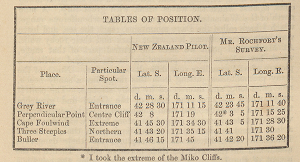
[Image of page 83]
Buller, seeing that in the tables of positions in the New Zealand Pilot, those points, with some others between the Grey and Cape Farewell, are laid down in degrees, minutes, and seconds. In preparing my map I was therefore not a little surprised at finding great differences between the results of the survey of Mr. Rochfort, who started from a well fixed point, and the tables of positions in the New Zealand Pilot.
In order that you may judge for yourself, I here place both results in juxtaposition.
* I took the extreme of the Miko Cliffs.
As it may be expected that within a short time the Grey and Buller rivers will be frequently visited by vessels, it is of the greatest importance to ascertain where the error lies. I may add, that my own hearings and observations accord very closely with Mr. Rochfort's survey, and I believe they will be found correct, principally for the following reason. The three peaks of Mount Murchison, which are visible from Nelson, are also visible from the mountains above the Buller, near its mouth. I had an opportunity of fixing the position of these three peaks from the mountain itself, looking towards Nelson as well as towards Lake Roto-iti and the adjacent mountain peaks, the positions of which I had before ascertained from the shores of the lake. I found their positions accord with my previous observations from all these points, as well as from two mountain peaks near the mouth of the Buller, which I ascended. On my return to Nelson, being anxious to check these bearings, I took them once more from two fresh points, and obtained a similar result, which would have been impossible had the positions of the Buller, Cape Foulwind, Omu Point, and Black Beef (or Northern Steeple) been inaccurately laid down in Mr. Rochfort's survey of the coast line. A great number of barometric observations, many of them in conjunction with the results obtained by the boiling
[Image of page 84]
water apparatus, have enabled me to give, in the accompanying table, the altitudes of many of the principal points over which I passed. I am indebted to Captain Rough and Mr. Christopher Maling for making, during my absence from Nelson, careful meteorological observations, which have assisted me in calculating with accuracy the tables in question.
Between the mouth of the Grey and the Waimatuku stream, the country is more level, and we found near the sea, between it and the foot of the Paparoha chain, a low limestone range of 100 to 150 feet high, forming a bold headland in the Komatiki-tawao cliffs, against which the waves break with great fury. A mile north of the Waimatuku, the spurs of the carboniferous range, which I have called the Davy mountains, reach the sea, and leave very little space between low water mark and their rocky walls. At Maukurinui point we meet the central part of that range, which here slopes down, presenting in its rugged outlines a picture of wild grandeur very difficult to describe. North of the many promontories jutting from this range lies a sandy beach, nine miles long, and intersected by many streams. The central range which rises at the head of the Okiwi and stretches thence in a straight course from north-north-east to south-south-west, is visible over some rugged limestone hills, which run about a mile inland towards the Pororari and reach the sea at the Punakaiki cliffs, known to the explorer for their dangerous ascent and for the caves on their northern side. Thence to the ascent of the Tuhinu, a distance of eleven miles, the coast is a continuous line of hills from 400 to 600 feet high, lying close to the shore and rising to the height of 1,000 feet further inland. Amongst these the Miko cliffs, where the traveller from the south has to descend perpendicular limestone walls for about sixty feet on ladders, are the best known. Here and there granitic hills reach the coast, and the rock, presenting occasionally a cuboidal structure, gives a new character to the scenery. The limestone and green sand cliffs, which principally constitute this part of the coast, are distinguished by the regularity of their stratification, which, from a distance, gives to their bold escarpments a ribbonlike appearance. At the foot of the Tuhinu, a continuation of these hills, which in many places are swampy, and covered with grass and rushes, with here and there a belt of forest, the coast becomes so rough, and the cliffs so steep, that the native track follows the ridge. The character of the country remains still the same, hills from 600 to 1,000 feet high, lie inland, running parallel with the high central chain, one range succeeding another, and each sloping abruptly towards the west. The numerous streams and rivulets which pass through them on their course from the rocky mountains have worked deep beds through the more westerly ranges, which at the Potikohua retire from the coast, and run parallel with the Buckland peaks.
[Image of page 85]
The Waitakere is a nice stream, to whose banks the path from the Tuhinu descends. The mouth of this river offers an anchorage for small craft, but I do not know whether the bar will permit it to be entered. At the northern side of this stream a small belt of forest separates it from extensive terraces, covered with grass and rushes, which commence here, and which are fringed on the coast line and on the margins of the intersecting streams by strips of forest. These terraces stretch across the Buller to the Waimangaroha stream, and are in fact the delta of the Buller, accumulated during successive ages. The coast line from the Waitakere to Tauranga is nearly straight, and consists, for nine miles, of a splendid sandy beach, upon which the Totara and the Okari, two considerable streams which drain the Buckland peaks, empty themselves. Tauranga is a small rocky projection, which has been united to the main land by an accumulation of drift-sand, forming small hillocks behind it, and extending tor several miles towards the south, near the coast; contrasting greatly with the wild scenery of rocks and promontories further down. Although some picturesque rocks occur between Tauranga and Omu Point, bordering the sea, and protecting the loose alluvial formation within against encroachment by the waves, the country still continues of the same character; that is to say, a terraced table land, from sixty to 150 feet high, which, near the Buller, descends to its level in successive terraces, from ten to fifty feet high. The Buller, or Kawatiri river, of which I have already treated, has a better entrance than the Grey, although its waters are shallower over the bar, being, as I have been told, only four feet deep at dead low water. A deep lagoon, of some extent, on its southern bank, offers a safe anchorage for vessels. The level terraced country on the banks of this river extends from six to seven miles inland, and will one day be found useful as an agricultural district, should either the gold fields of the middle Buller, or the extensive coal-fields on its northern bank, induce a European population to settle there.
Advancing towards Cape Farewell, the level land contracts, the Papahaua range approaching the coast. About ten miles north of the Buller the level country ceases entirely, the spurs from Mount Frederic falling to the water's edge. Behind the Ngakuwaho stream, which drains part of the southern slopes of the Papahaua chain, is a good sandy beach. Here again the hills are low, and have between them broad valleys, covered with luxuriant forest, and intersected by small streams. Above them tower the snowy peaks of the Lyell range, the western base of which is five miles distant from the mouth of the Mokihinui, a stream of considerable size, which drains a large extent of country, and derives its waters principally from the northern slopes of those mountains. From the Mokihinui to the Wanganui river a distance of twelve miles, the coast has similar features to those
[Image of page 86]
near the Miko cliffs. Granitic cliffs and promontories, many of them formed by the huge boulders brought down by the numerous mountain torrents which here reach the sea through deep gorges, alternating with limestone cliffs, of which some, like the Bluffs of the Otahu, reach an altitude of 700 to 800 feet, and offer nearly perpendicular faces to the foaming surf, presenting, far away from the seaward, the appearance of remarkable fissures. Here the journey must be performed rapidly, to avoid being caught by the rising tide, it being, in many places, only possible to pass at dead low water. At the Wanganui river, the southern branch of which comes from the Lyell range, we again meet with level land, consisting of terraces, covered partly with valuable timber, and partly with rushes and swamp grass. This low tract of country continues for twelve miles to the north, and at its southern part is from six to seven miles broad, narrowing where the Karamea enters the sea. The Karamea plains are watered by the rivers Wanganui, Otumahaua, Karamea, and Oparara, and offer a fine spot for settlement. The high rocky mountain chain, of an average altitude of 6,000 feet, forming the Tasman mountains, a continuation of the Lyell range, show themselves above the low land in the foreground, running in a northerly direction towards Mount Domett, a gigantic snowy pyramid, in which lie the sources of the western branch of the Karamea, of the Haihai, of the southern branch of the Wakapoai, and of the Aorere, the waters of which fall into Golden or Massacre Bay. The Lyell range has been laterally dislocated at its northern end, and a valley, containing low granitic hills, lies between it and the Tasman mountains, trending towards the Matiri. Through this dislocation I have no doubt that an easy pass will be found from the Karamea plains to the Matakitaki plains on the banks of the Buller.
The Tasman mountains are broken through by many rivers and streams, which run with great velocity towards the coast, and some of which flow through deep and frightful gorges. The sources of the Karamea, the most considerable river north of the Buller, will probably be found near those of the Takaka, and may even extend into the western slopes of Mount Arthur, and thus lie near the head-waters of the Wangapeka, which, after joining the Motueka, falls into Blind Bay. From the great body of water which it carries, it must drain a considerable part of that unknown country. Five miles south of the Haihai, limestone ranges again occur, and thence to the Ihua-tuaroa point, with the exception of the Wakapoai valley, there are scarcely ten acres of level land, wild precipitous cliffs forming the only boundary to the foaming sea. The valley of the Wakapoai, if brought into connection with Collingwood, would offer an excellent situation for a small settlement; but it has yet to be proved whether small coasting craft can enter its mouth in safety.
From Ihua-tuaroa point, where a lower country and sandy
[Image of page 87]
beach replace the huge rocks over which we had wearily dragged for several days, we found, on our way to Cape Farewell, several good sized streams flowing in a northerly direction from the granitic and slaty mountains left behind at Kaurangi point. Cretaceous hills again appear, between which, near the coast, lie hillocks of drift-sand, the former lying at the western base of the Whakamarama range, which itself forms the western boundary of the Aorere valley, and attains in the Haidinger peak, its greatest elevation of about 4,000 feet. This range terminates near Pakawau, and it is here that the cretaceous hills, which, south of the West Wanganui inlet, attain an altitude of 1,000 feet, and strike across the island, only broken through in that interval by the marshy valley of the Mangamangarakau which forms the southern arm of the inlet, reach the east coast, covering the country to Cape Farewell, and presenting the same physical character as the previous limestone country, deep gullies and steep hills, often with perpendicular cliffs on both sides, and which at Cape Farewell are still 500 feet high.
As my distinguished friend Dr. Hochstetter has already treated of the formation of the sand-spit which commences at this cape, I shall not offer any remarks upon this interesting phenomenon, which, from the summit of Cape Farewell, offers so striking an object to the eye of the observer.
TABLES OF ALTITUDES.
The numbers marked with a * are the results of observations obtained both with the aneroid barometer and with the boiling water apparatus.
|
|
FEET.
|
| * Brook-street-hill, near Nelson
|
2,411
|
| Fox-hill
|
263
|
| Saddle between Wai-iti and Motueka valleys
|
1,174
|
| Mr. Hooker's station in Motueka valley
|
879
|
| Saddle between Rainy river and Lake-house valley
|
2,324
|
| * Lake-house
|
1,589
|
| * Lake Roto-iti
|
1,881
|
| Mount Robert, northern plateau, above lake
|
4,722
|
| * Mount Robert, summit
|
6,144
|
| Junction of Howard with Roto-iti river
|
1,419
|
| Summit of hill between Howard and Lake Roto-roa
|
3,415
|
| * Lake Roto-roa
|
1,623
|
| Mount Maclean
|
3,635
|
| Mount Murchison, north-western summit
|
4,672
|
| * " " " " south-eastern summit
|
4843
|
| Saddle between Leader creek and sources of Mangles.
|
2,329
|
| Tiraumea plains
|
1,124
|
| * Junction of the Roto-iti and Roto-roa rivers, forming the Buller
|
1,127
|
| * Junction of the Mangles with the Buller
|
509
|
| * Junction of the Mataki-taki with the Buller
|
427
|
| Mount Francis
|
2,135
|
| * Junction of the Maruia with the Buller
|
334
|
| * Centre of the Maruia plains
|
1,321
|
[Image of page 88]
|
|
FEET.
|
| Bog saddle between the Maruia and the Grey
|
1,623
|
| Point at which the Grey enters the depression
|
1,276
|
| Junction of the Alexander stream with the Grey
|
841
|
| * Deception-hill
|
4,313
|
| * Black-hill
|
4,605
|
| * Junction of the Mawhera-iti with the Grey
|
488
|
| Junction of the Ahaura with the Grey
|
317
|
| Saddle between the Mawhera-iti and Inangahua
|
1,127
|
| Coal-field of the Grey, near the river, main seam.
|
83
|
| Tuhinu-hill
|
756
|
PAPAHAUA RANGE.
| * Mount Rochfort, highest summit
|
3,572
|
| * Mount William, ditto ditto
|
3,611
|
| * Coalbrook Dale, on plateau
|
1,914
|
| Otahu-hill, southern bank of Tunipohu
|
1,067
|