[Image of page i]
[Image of page ii]
[Image of page iii]
[Image of page iv]
[Image of page 1]
EXTRACT FROM THE FEW ZEALAND MAGAZINE.
August, 1862.
A VISIT TO THE GREENSTONE COUNTRY, By Charles Heaphy.
Te Wai Poenamu, or the water of the greenstone, is a name written in the old charts against a lake in the Middle Island. Cook calls the whole island Tovai Poenamu.
The words are corruptions of Te Wahe, or the place of the poenamu.
To explore this country Messrs. Brunner and Heaphy left Nelson on the 18th March, 1846, purposing to follow the western coast on foot. In the previous summer they had been stopped, when on an inland track, by the mountainous and wooded country of the gorges of the Buller river, in lat. 41° 50'.
The course now lay from Massacre Bay, past Rocky Point, and the place marked on the chart as the "5 fingers". On leaving the Aorere river in Massacre Bay, each traveller carried a weight of 85 lbs. of provisions and instruments, the former consisting of 40 lbs. flour, 10 lbs. sugar, 1 lb. chocolate, with 8 lbs. powder and shot, the weight being made up with
[Image of page 2]
spare boots, blanket, book sextant and compass, with a few presents for any natives that might be fallen in with.
By the difficult coast track at Rocky Point, and past the old sealing haunt at Toropuhi, only three miles a day could be made with the heavy loads and the rock-climbing. Large fragments of granite, from ten to sixty feet in diameter, composed what represented the beach; and, at low water, amongst these, and between them and the surf, the path lay.
Inland, high granite ranges, forest-covered, blocked up all passage save where some old war path had been cut to avoid a jutting point which the tide beat against, and where it was necessary to ascend some five hundred feet and keep the hill side for a mile or more; the descent generally being by the bed of a torrent, or by a supple-jack rope over the cliff.
The great disadvantages of a coast route, when there are no natives, is that all the rivers have to be crossed where they are widest, at their junction with the sea. At the Awaruatu, Karamea, and Mokihi-nui, rafts had to be made. The most buoyant raft is made of korari, or the dry flower stalk of the flax, which is made into bundles ten or twelve feet long, and as thick as a man's body. The bundles are lashed together into
[Image of page 3]
a boat-shaped raft about 24 feet long and 4 1/2 feet wide, tapered towards the ends. Paddles have to be cut, and with a weight of 500 or 600 lbs. a river of half a mile broad may be conveniently crossed. With a greater distance the material becomes saturated and the raft loses its buoyancy.
With the exception of the Wakapoai and Karamea valleys, each comprising perhaps 40,000 acres of good land, without a harbour, the whole country, from Cape Farewell to the delta of the Buller river at Cape Foulweather, consists of alternate granite and limestone mountains, with their sides washed by the sea. At the mouth of the Buller is a triangular flat of about 60,000 acres, composed of the debris of the inland valleys, brought out by the river, which has scarped them into terrace shapes like the shelves or "parallel roads" of Lochaber.
The Buller is a noble river, smooth, and upwards of 400 yards broad, here a small canoe, minus one end, was found, and the long and tedious construction of a raft obviated. A lump of clay, carefully renovated during the passage, filled up the end, and the river was crossed safely. Beyond the river a large pine forest has been submerged by the lowering of the coast, and a succession of huge trunks stand out on the sands at low
[Image of page 4]
water mark.
At Tauranga beach, penguins and wekas, or wood hens, were in abundance. After one moonlight night's hunting, with a small Scotch terrier dog, the game list stood thus: 8 penguins, 23 woodhens, together with 2 bull-trouts and 1 eel.
On crossing the low ridge of Cape Foulweather, the coast for nearly 150 miles becomes visible. The winter had set in -- it was the 3rd of May - and the mountains within six miles of us, and far away to Cascade Point, were clothed with snow two-thirds down; and on the ground about us unmelted hail lay during the whole day. Far away to the S. S. W. the glaciers of the Southern Alps of Cook formed the most distant point, all that was not snow-covered being below the water horizon; while out beyond these, looking like a detached iceberg, was the summit of Mount Cook, 13,300 feet high.
The Buller river has at various periods had different outlets on the low triangle of land near Cape Foulweather, and the soil, composed entirely of alluvium and decayed vegetation from the dense forest which everywhere covers it, is of great richness. The entrance of the Buller is, for a bar harbour, tolerably free from breakers, a smoothness which it owes to the projection of the adjacent cape, and cluster of rocks called the
[Image of page 5]
Three Steeples, or, by the sealers, the "Black Reef". Small coasting vessels will one day frequent this haven, and a site for a prosperous settlement exists on the level flat of the cape which may comprise about 70,000acres. 1
The "Black Reef" was, about 40 years since, a great resort of sealers. In its cluster of islets the sealing boat could nearly always find a "lee" from the heavy westerly swell, and the rocks swarmed with the fur seal. Even on the beach at Tauranga, abreast of the reef, the sealers, suddenly landing at low water, have intercepted a "school" of seals, and knocked them on the snout, or lanced them as they made their way clumsily down towards the sea. From Dusky Bay and Milford haven up to Toropuhi, or Rocky Point, the sealers, with a hardihood and contempt of danger which even in whaling finds no parallel, visited every rock and reef on a coast that is iron bound alike to canoe and sailing vessel. 2
Provisions now became scarce: for ten days the ration of flour had been one tablespoonful each, and that was used as thickening for soup, made from any bird that might be snared. The surf was too high to admit of fishing, and mussels, of which there were in some places abundance, caused dysentery. The sea-anemone or toretore was more wholesome, being rather gelatinous,
[Image of page 6]
but, being very salt and gritty, was not palatable. The mamaku (Cyathea medullaris), where it could be found, gave a fair vegetable esculent, and we frequently carried large junks of this as provisions for two or three days in advance.
After the triangular flat of Cape Foulweather was passed, and at the spot marked on the old charts as the "Five Fingers", the mountains again came abruptly down to the sea, and the travelling was again slow and difficult. Progress could only be made at dead low water; and in the short winter days of May the journey so pursued was most tedious. Not unfrequently two and three days would be lost in waiting for a flooded river to subside, or for the surf to go down at some jutting cliff that could not be avoided.
At Potikohu, in the conglomerate rock, is a remarkable cavern, having three entrances from opposite sides, and composed of a vault 140 feet long, 30 feet wide, and 25 feet high, with its various branches. in this cavern, on a gibbet, as a security against rats, we left - for our return journey - our reserve stock of 6 lbs. of flour and 2 lbs. of bacon. Our ration of one tablespoonful of flour a day had been for thirteen days resigned, and during that period we had lived on snared birds and mamaku. Our gun, too, was left here, with three charges of powder; for several weeks it had been
[Image of page 7]
used with the main spring tied in with pack-thread, it having become unrivetted. The old boots were also left as a reserve, and we walked on awkwardly over the rocks in new water-tights.
At Potikohu we were 220 miles from Nelson, and l52 miles from the natives of Wanganui, the nearest point at which we could obtain provisions on our way back. Of the distance forward to the Greenstone Country we had but a vague idea, supposing it to be about 80 or 100 miles. To take us this distance we had not an ounce of food, unless a small scotch terrier dog might be regarded as such - it was in as lean condition as ourselves.
Difficult descents were again unavoidable, and a peculiar description of ledge walking on the slopes of the mountain, over the surf, became necessary, but we had grown used to such clambering. Both the eye and the foot become educated to such work with daily and almost hourly practice extended over a period of months.
So uninterrupted is the expanse of forest on this coast that over 120 miles only one small spot presented itself where fern grew, and its root could be obtained for food. From that place on our return we carried fern root for ten or twelve days.
The peculiar geological formation of granite and
[Image of page 8]
fossilferous limestone in juxta-position, still continued the limestone showing coal at Ngawiakakiri and Irimawi.
At neither of these localities, however, is there a harbour or shelter from the westerly swell and its never-ceasing surf.
On the 19th of May, on passing Maukiranui Point, we saw at a distance of 300 yards a small native village, and some women gathering shell-fish on the sands. A shout immediately arose, and the inhabitants poured out from their pah in wonder at our appearance.
As we approached them they drew up in single file with their chief at the nearest end, and without saying a word presented - man, woman, and child - each a nose to be rubbed.
The village - Kararoa - was an out-station of the Greenstone community, and there were in it one man, two boys, seven women, and twelve children. Of these only the old man and woman had ever seen a white man - they remembered the sealers.
No enquiry as to our object in coming was made, and until cooked food had been placed before us scarcely a word was spoken. Every face looked its astonishment, and each article of our dress and equipment was examined with the minutest scrutiny. Then, after the three or four families had each furnished a mess of potatoes and
[Image of page 9]
dried white-bait - more by far than we could consume, famished as we were - then they asked us how we had passed the Taupare Kaka cliff, and descended the ladders at Temiko; what food we had obtained on the way; and how we forded the Karamea; every quest ion being dictated by a feeling of interest rather than of inquisitiveness. After resting two days at Kararoa, we again started for Tara makau, the chief settlement of the tribe, all the people of the village accompanying us.
Near the Mokihinui river we had for many days found pieces of Baltic deal and English oak, copper fastened, until it became evident that some large vessel had been wrecked somewhere in the vicinity; at last, near Mautoria, we found the broken masts and main top of a ship that must have been of about 400 tons burden. On our way, now, the natives told us of the loss of this vessel, She had anchored near Cape Foulweather for water, and the captain had landed with some of the crew, when a heavy westerly gale prevented their return on board, and the short-handed vessel, in endeavouring to beat off the coast, was embayed and wrecked where we had seen her - some twenty-five miles from where the captain was landed. The crew, thus divided, endeavoured by means of a breastwork to defend themselves against the natives, but after a few days had to surrender, when they were all
[Image of page 10]
killed and eaten, save two, of whom the captain was one. These evaded the native pursuit, and without provisions and barefooted, walked - chiefly at night - along the rocky coast that we had passed towards Cook's Straits, in the hope of reaching the whaling station at Cloudy Bay, 400 miles distant by the path. The west coast natives followed their footsteps as far as Cape Farewell in hope of capturing them, but were continually eluded. Passing Massacre Bay the two fugitives actually reached Totara nui beach, round Separation Point, where the local natives surprised and killed them. Could they have told their tale, no narrative of toil, endurance, and courage could have exceeded theirs in melancholy interest.
The natives described bales of wool as having come ashore from the wreck; she was probably a vessel from Van Dieman's Land on her way to England. 3
We continued on, and passed the entrance of the Mauhera or Grey river, in lat. 42°28'. here there is a fine valley, extending to the northeast, and connected with a splendid district for agriculture, bounded on the south by the Mount Cook range, and on the east by the Southern Alps towards what is now the Canterbury district.
At Taramakau, eighteen miles from Kararoa, we came upon the chief settlement of the Ngaterarua, or Greenstone people, some forty souls in all, and every
[Image of page 11]
man, woman, and child indolently engaged in sawing, grinding or polishing greenstone.
Tara Makau village was unlike any other native settlement in New Zealand; every house had a chimney and there being no pigs or other neighbours, fences were unnecessary, and the Taros and potatoes grew about and between the houses.
That we had at length reached the veritable greenstone country was very evident; outside the principal house the chief of the place had lain by a slab of Poenamu, out of which he was sawing a meri when he came to welcome us. In another place, an old man - too old to move out to meet us - chanted some sort of song of welcome, and kept up a sawing accompaniment. Little children ran about with toy pieces of kawa kawa; and brought us smooth pebbles of it, as presents. Hei Tiki, the uncouth figures with red sealing-wax eyes that are worn hung round the neck - were receiving the last polish; and fragments of greenstone - odd knobs, and rejected cross-grained pieces were lying about the houses, and down towards the beach, in a way that would have made a ngapuhe crazy could he have beheld it.
Along the whole extent of the west coast - from Cape Farewell to Dusky Bay - this is the only Maori community. 4 The people are chiefly a remnant of the Nga i tau tribe, that formerly occupied the country about
[Image of page 12]
Otago and Bank's Peninsula, and extended over the island to the western coast for the purpose of working the greenstone. Rauparaha and the Taranaki tribes with their guns scattered them in a series of bloody engagements on the east coast, and afterwards the Ngatitoa tribe under other leaders came down from Massacre Bay by the coast track that we had followed and defeated them on the west side. But the sight of the poenamu had a pacifying influence, and before long inter-marriages took place; some of the Ngatitoa remaining at Taramakau and others returning to Cook's Straits with a tribute of greenstone meris.
The supple-jack and aka ladders at the miko cliff, and the ledges that we had travelled by coming along the coast had been the war track of this party, - it was too far, however, and too laborious a journey often to be undertaken, and the greenstone people had been left alone by the conquerors - save when occasionally some enterprising chief would make the journey for the sake of obtaining a meri poenamu. Many, however, they told us, had turned back again, when they reached and looked down the precipice at Tau pari kaka.
Cut off by their position from all intercourse with the Europeans - save as I have mentioned with the sealers - these people had received but very few of the
[Image of page 13]
advantages which have accrued from our coming. They had the potato, and a small patch of maize for seed, but neither the pumpkin, melon, cabbage, peach, or any kind of grain. Pigs they had never seen, nor horses. A chief who had gone with the conquerors to Cape Farewell had, on returning, carried on his back two young goats - but one died on the journey, and the attempt to introduce them was unsuccessful. Some of the men had been across to Akaroa, and had purchased there two iron pots which they carried back with therm, and the Maori visitors who came occasionally for poenamu, would bring a steel axe as homai n'homai for a meri.
There were of course no blankets to be seen, or any vestige of European clothing: the coarse koka mat was the most common article of covering, but in their boxes were beautiful specimens of the black-stringed porowai and of the silky kaitaka. In no part of New Zealand had we seen such beautifully made mats, or so many of them.
The forests of the western coast are more tenanted by birds than those elsewhere in the islands. The wood-hen or weka is very plentiful, and the large kaka-po or night parrot, with its green and gold plumage, is snared for its flesh and its skin. Pigeons - unscared by the gun - are in enormous numbers, and are speared in the low scrub by the natives with great facility. A long,
[Image of page 14]
thin, and very limber spear is used, pointed at the end with a sharp and barbed bone, and with this the native steals under the bird, and slowly and quietly insinuates its length through the foliage until the point is within a foot of the pigeon's breast, when with a sudden jerk it becomes impaled.
The native of the bush here - depending for his subsistence during half of the year on what the forest produces - is a very different character to the lazy inhabitant of a northern pa. Every call or whistle of a bird he can imitate, and so well as to lead the weka or kaka-po up to him, as he crouches, covered with his flax mat, and motionless. The call that enticed the bird at 100 yards distance, fails of its blandishment when a few feet only are separating them; and a gutteral croak, repeated with discretion, and at proper intervals draws the stupid wood-hen up, until a flax noose is put, with the aid of a stick, round her neck, her own cry of alarm is then used to entice her companions, who come up to see what is the matter, and are also noosed.
In the forest, one of these men can follow not only a man's trial - that I have often seen them do -but a bird's trail, and will capture a wood-hen, or, amongst the rocks, a penguin, from indications that a Northern native or a white man would not have recognized
[Image of page 15]
Great numbers of wood-hens and pigeons are taken in the summer and preserved in their fat, rendered down, in the bladders of the kelp sea weed. Food of this kind they brought to us at Ara-Hura, together with quantities of dried Inanga or white-bait, taken with fine meshed nets, of enormous length, in the rivers. Sea fishing is impossible on account of the surf, and with the exception of a few small kaupapas, or river shallops, there are no canoes.
The mountainous coast terminates near the mouth of the Mawhera, or "Grey" river, in latitude 42°28'30", and the difficult rock travelling ceases. Long sandy beaches stretch towards Bold Head and Cascade Point, and a fine country, more like Taranaki than any other part of New Zealand, lies inland and abutting on what is now the Canterbury district.
To the north-east the valley of the "Grey" extends inland towards the lakes of the Nelson country and appears fertile and easy of access: to the east some excellent land, apparently of great fertility, extends from the coast to a range of wooded hills about twelve miles back. To the south-east another valley, that of the Arahura, seems to carry level land to the centre of the island - no mountains breaking the horizon or rich wooded land over 20 deg. in that quarter.
[Image of page 16]
On pushing into the hush, the land appeared of a very fertile nature - rich vegetable mould supporting a growth of low forest and scrub, with rills the size of English trout streams every mile or so, and occasionally a river, too deep for wading.
But the surf! Ever heaving in from the western horizon come those heavy long even rollers, with their thundering surf, crashing on the reefs or curling and smoking on the sand beach, with the low hiss of the receding wave - the lee shore of twelve hundred miles of ocean.
The Buller, the Grey, and perhaps the Mokihinui rivers are the only accessible points on this coast. Steamers of light draught may one day navigate these, and well-managed sailing craft may enter the two first. Will surf-boats ever take off the produce from these long beaches? Deal boatmen will take out a 24 cwt. anchor through as heavy a surf.
The poenamu is a vein stone, like quartz or feldspar, and traverses rock of primitive formation. The river Arahura, nine miles from Taramakau, appears to cut through some veins of this stone and to bring down fragments of it in the floods. On the subsidence of the water the natives wade about searching for it in the
[Image of page 17]
river bed, and the heightened colour of the stone in the water soon reveals it to them.
Of poenamu there are the following kinds, viz:
1st., The inanga; 2nd, the kauairangi; 3rd, the kawa-kawa; and 4th, maka tangi wai.
The inanga is the most valued by the Maoris; it is rather opaque in appearance, and is traversed with creamy-coloured veins. The best meris are usually made of this stone.
The kauairangi is of bright green colour, with darker shades or mottled, and is the most translucent; it is a brittle material and not easily worked; ear pendants are frequently made of it.
The kawa-kawa is of a dark olive green, and has rather a dull and opaque appearance, hei tiki and ear pendants are composed of it.
The maka tangi wai is the least esteemed by the Maoris, but by far the most beautiful of all. It is of clear pale green, and is very translucent. The natives will drill a hole through a pebble of it and hang it to a child's ear, but do not care to fashion it into any shape. It is the only kind of poenamu that would be esteemed for purposes of ornament by Europeans.
in order to make a meri a stone is sought of a flat shingly shape - say of the size and roughly of the shape of a large octavo book. Among the primitive rocks
[Image of page 18]
of the Middle Island stones are not wanting of sufficient hardness to cut even the poenamu, and the Ara Hura natives lay in a large stock of thin pieces of a sharp quartzose slate, with the edge of which, worked saw fashion, and with plenty of water, they contrive to cut a furrow in the stone, first on one side and then on the other, until the piece may he broken at the thin place.
The fragments that come off are again sawn by children and women into ear pendants. With pretty constant work - that is, when not talking, eating, doing nothing, and sleeping - a man will get a slab into a rough triangular shape and about an inch and a half thick in a month, and with the aid of some blocks of sharp sandy gritted limestone will work down the faces and edges of it into proper shape in six weeks more, the most difficult part of the work is to drill the hole for the thong in the handle. For this pieces of sharp flint are obtained from the Pahutani cliff, forty miles to the north, and are set in the end of a split stick, being lashed in very' neatly. The stick is about fifteen or eighteen inches long, and is to become the spindle of a large teetotum drill. For the circular plate of this implement the hardened intervertebral cartilage of a whale is taken; a hole is made through, and the stick firmly and accurately fixed in it. Two strings are then attached to the
[Image of page 19]
upper end of the stick, and by pulling them, a rapid rotatory motion is given to the drill. When an indentation is once made in the poenamu the work is easy; as each flint becomes blunted it is replaced by another in the stick, until the work is done.
Two meris were in process of formation while we stayed at Tara Makau, and one had just been finished. A native will get up at night to have a polish at a favourite meri, or take one down to the beach, and work away by the surf. A piece of greenstone and some slate will be carried when travelling, and at every halt a rub will be taken at it. Poor fellows! they had no tobacco, and a grind at a piece of hard inanga seemed to be a stimulant.
At the Arahura river we were 272 miles from Nelson. Mount Cook, though still 69 miles distant, appeared, from the whiteness of its snow and glaciers, and its immense height, to be quite close. It stands high above a range of snowy summits of the southern Alps, as high again as any of them, and has the angular outline of the granite rock, with the precipitous sides and chasms.
The hospitality of the poor people of this place was extreme. The laid-up stores for the winter were freely and unhesitatingly appropriated to our use, and
[Image of page 20]
no mention made, and, I believe, no thought entertained, of payment. We left them, however, an axe, some fishhooks, and a few pipes and needles.
The account may be interesting of how, in the midst of winter, we accomplished the journey back without sugar, tea, meat, or flour. The journey from Nelson to where we first saw the greenstone village had taken us 62 days to walk, and it was not without anxiety that we thought on the long rock-tramp that was before us, with at best, potato food.
On the 6th June we left Mawhera, with 60 lbs. weight of potatoes - carefully washed and sorted - and about 5 lbs. of dried white-bait each, besides blankets, books, and a few presents of poenamu.
Heavy rains and flooded streams detained us four days almost at the outset of cur journey, and a ration had to be at once fixed of six potatoes a day. On the 13th, at Punakaiki, we found two dead ling on the beach thrown ashore by the gale: we made them into soup, and reduced the potato ration for two days to three each. With our heavy loads, the ledges and cliffs at Punakaiki and Pororare were of rather critical passage. On the 14th we descended the cliff by the ladders at Te Miko, and on the next day baked a hangi of mussels at Irimaui.
As on our journey downwards so now only three
[Image of page 21]
or four miles a day could be accomplished - walking at dead low water, and waiting during the flood and first of the ebb. The winter, too, seemed to have driven the birds away to some other district, and a wood-hen or a penguin was now quite a rarity. The potato food began to tell on our strength, and although our loads were lightening, they seemed daily to become heavier.
On the 17th of June, at Potekohua, we endeavoured, but unsuccessfully, to catch some fish in a lee afforded by some outlying rocks. During the detention, however, we baked a hangi of mamaku or fern tree pith.
Three days' detention by rain and floods, with only four potatoes each daily and what fish might be thrown ashore by the surf, depressed us considerably; but on the 22nd we caught, with the aid of the terrier dog, nine penguins - ate one each, and carried on the others towards the Buller river, where we expected detention. Rain, and floods in the Homau river, detained us for three days before arriving there.
On the 29th, however, we caught a wood-hen and found four blind eels cast on the sand. Gathered korari for a raft by which to cross the Buller - the canoe having been taken away by bush natives.
30th. - Made two rafts of dry totara logs and korari, and at flood-tide launched them on the Buller. A heavy swell was rolling in from the bar, but the rafts
[Image of page 22]
breasted it gallantly, and with hard paddling we crossed the river safely. After dinner, walked on to the Oroaiti tide lagoon to catch flat fish by torchlight; fishing a failure, but we killed a wood-hen that was attracted by our light, and we ate it.
On the 3rd duly, at Mahutoria, our potato ration, self-imposed - was three potatoes a day made into broth with what might be found on the beach, and a little shaking of flour from the 6 lbs. reserved in the cave at Potikohua.
On the 5th we crossed the Mokihinui on a raft of dry kahikatea logs. We were now very weak from want of proper food and from dysentery, caused by eating shell fish. Although feeling the want of solid food, thirst was chiefly the manner in which the privation troubled us; at every stream we came to we drank eagerly, the weakness and the rough travelling causing some slight degree of fever.
On the 8th duly we obtained some toretore or sea anemonies. This was the best food, by far, that the beach afforded, there being a good deal that is gelatinous in its nature, but for the toretore soup which we made here I do not believe we should have got farther.
9th. Cliff walking at Otahu, and descended by the watercourse to the beach at Tunupohu after dark in
[Image of page 23]
order to save the tide.
10th. Shot a toria with our last reserved charge of powder; the only bird shot since April 11th.
11th. Found a dead ling at Otumahana; made soup of him.
19th. Still along the cliffs and tide points. Only three miles a day could he attained on an average when walking, with often a detention of three or four days by a flooded river that would not admit of rafting until the freshet had subsided. On Sunday 19th we suffered for the first time from cold; our blankets - one each - were by this time very thin, and as we could not erect a hut each night, we made a large fire on the beach, rolling some logs or stones together for a break-wind, and replenished the fire every few hours, but now a spiteful tonga blew, cold and cutting from the Karamea snowy range, and neither blankets nor fire would keep us warm. Found the remains of a dead pigeon, the rats leaving it as we approached; made soup of it with wild rock parsley.
20th. Saw several seals on the off shore rocks, but had no means of obtaining one; found a dead cormorant, carried it on and supped off it with sea snails.
22nd. Food more plentiful. Last night caught a wood-hen, and at Moutere gathered sea slugs or beche de la mer. At last, on the 24th July, we arrived at the old potato grounds of Rawkawa, and all anxiety as to want of food was over. On the 5th August, to our great delight
[Image of page 24]
we found at Wanganui a tag of 20 lbs. of flour, with some sugar and tobacco, that had been kindly forwarded to the natives of that place for us by Mr. Fox of Nelson.
On the 18th of August we arrived at Nelson, having preserved "Smutty", the little terrier dog, uneaten!
Footnotes.
[Footnotes have been inserted in the text.]
[Image of page 25]
(Pages 107, 108, 109, 111), 111, 166, 167, 166, 169, 170, 171.)
[Image of page 26]
[Page 26 is blank]
[Image of page 27]
[Found between pages 9 and 10]
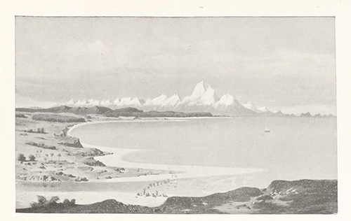
Fig. 80.
THE SOUTHERN ALPS.
View from the mouth of the Brunner River on the West Coast. (From Ferdinand von Hochstetter, New Zealand, 1867, p. 38.)
BRUNNER is an early name of the Hokitika River, after a Nelson explorer who, in 1848, made a noted exploration of the difficult and then inhospitable district of Westland. The earlier Maori tribes were subdued and dispossessed by the more vigorous Ngaitahu, who had already taken possession of the Canterbury side of the island, there dispossessing and driving south the Ngatimamoe. The branch of the Ngaitahu who took up their residence on the Westland side was known as the Poutini.
The view, which looks south, shows a party crossing the river; Abut Head, 40 miles distant, and Cliffy Head, 30 miles, forming the projecting headland seeming to be under the towering mass of Mount Cook, which is about 70 miles distant. That mountain looks exaggerated in the picture; but the artist has not exaggerated the impression that noble block of snowy mountain makes on the observer at all times, and particularly when a clear air allows a sight of the great mountain's lesser but still majestic surroundings. All this Wesland, coast flanked by the wild sea and with its almost impassable rampart of mountain, was a difficult land to woo and to win; a land of swift rivers in deep and steep valleys thickly grown with evergreen bush whose interior was usually thick with ferns and wet with mosses; and whilst the birds of the air and of the earth made it a melodious and weird home, the son of man could hardly find where to lay his head.
The Arahura, famed for its greenstone, some story of which has been told at pages 234-5 above, enters the sea about 6 miles on the hither side of the Hokitika. The whole district was transformed when over-run by the gold-seekers in the early 'sixties. First the early inhabitants were despoiled of their greenstone; then the land itself of its gold. It is still beautiful.