CHAPTER II. ON THE PHYSICAL GEOGRAPHY OF THE CANTERBURY PLAINS, WITH NOTES ON THEIR GEOLOGICAL STRUCTURE.
[Image of page 26]
CHAPTER II.
ON THE PHYSICAL GEOGRAPHY OF THE CANTERBURY PLAINS, WITH NOTES ON THEIR GEOLOGICAL STRUCTURE.
THE Canterbury Plains, which, by their position, nature, and general characteristics, form such a prominent feature in this Island, and which, one day, will be the centre of a rich, industrious, and large population, begin at the dolerite plateau of Timaru, and stretch without interruption to Double Corner, in a general direction from S. W. to N. E., and with a length of about 112 miles.
Their breadth from a few miles at both extremities, north and south, augments as we advance towards their centre, having their greatest lateral extension near Banks' Peninsula, where, in a direction from east to west, they stretch a distance of more than fifty miles to the base of the mountains.
The Pacific Ocean is their boundary on the eastern side, where a long shore line stretches in a line nearly from S. W. to N. E., bulging towards Banks' Peninsula from Timaru to Double Corner, only interrupted by that volcanic system which rises so conspicuously in the middle of that low shore, and to the existence of which a great portion of the loose strata composing them owe mainly their preservation from the destructive agencies of the waves and currents.
The western boundary is formed by the outrunning spurs of the southern Alps, which, as I have shown in the first chapter, have, by their disintegration, offered the material for the present configuration and physical features of those plains.
In their greater bulk they consist of the accumulations of pleistocene torrents, which, having had their glacier sources much nearer to Banks' Peninsula than in present times, were able to throw the boulders, shingle, sand, and loess, which they carried along with them, not only in greater masses but also on steeper slopes than the present rivers which cross them can do for reasons previously given.
These pleistocene fans of huge rivers have covered with an almost uniform gradient the palaeozoic, volcanic, or tertiary rocks, which compose the former sea bottom, and where the present rivers or the sea, from causes already partly explained, had not the power to destroy or to cover them in their lower part.
[Image of page 27]
For instance, we can follow the great united fan of the three largest pleistocene glacier torrents, which form by far the most considerable part of the plains, down to the sea, and study its nature in fine sections exhibited in the present river-beds, and also at the sea shore itself, where the vertical cliffs of shingle and sand, closely packed together, give to the observer every facility for their examination.
The tables which I offer with this chapter will give the general statistics in explanation of the physical features of the plains, and I may add here that as I could not obtain many altitudes taken with the spirit-level, or by similar more accurate manipulations than those procured by barometrical observations, I was obliged to calculate by far the greater part from the latter, which I had in my possession.
In my Progress Report, dated July, 1861, and addressed to the Secretary of Public Works, I pointed out, by giving some other altitudes, what value could be placed upon these observations, which for purely topographical purposes, or others where a mathematical correctness is not required, may be considered sufficient.
I give them only for what they are worth, but think, nevertheless, that they will be found not to be far from correct, till in future days more accurate but more costly and time-taking methods can be employed than those at my command.
The most undisturbed part of the pleistocene accumulations lie between the Ashburton and the Rangitata, and it is here that the mean from gorge to sea shows us a fall of 45 feet to the mile or 1 in 117, whilst the upper part from the base of the mountains to the railway section, has a fall of 49 1/2 or 1 in 106 1/2, and hence to the sea of 33 1/3 or one in 158. In other parts of the plains similar results are obtained.
Some of the rivers, which, by their greater volume of water, had sufficient power to deepen their channels, and, crossing the line of intersection, form new fans over the older ones, show again that the gradient of their newer channel has only a very slight diminution between its upper present bed and the newly-formed channel, as, for instance, the Rakaia, of which we possess accurate data, where the difference is only three inches per mile between its upper and lower course on the plains proper.
In examining their surface, we find that to the eye, when ascending towards the mountains, they seem almost without any rise, the gradient being so inconsiderable; but, going across them, we soon meet many inequalities, as the courses of the former pleistocene rivers, by which the
[Image of page 28]
shingle was distributed, are easily distinguished, forming shallow longitudinal depressions radiating from the gorges of each river. Moreover, the nature of the surface exhibits a great difference. Here and there we pass over very stony tracts, and not much imagination is required to perceive, instead of the yellow grass which grows scantily among the shingle, a torrent of yellow water descend in them. At many other localities the river channels have disappeared, and vegetable earth or loam offers a better and more suitable soil for the endemic vegetation. Several causes may have been in operation to deface the former river beds, or improve their bottom, as, for instance, the surface waters bringing vegetable soil down from higher parts of the plains, or winds being in a minor degree the agents for a similar purpose.
Another obliterating and improving agency, and which I consider the principal one is, if any given locality, which, having been in its turn a river channel, has served afterwards for a long while as a backwater during heavy freshes, forming a good locality for the deposition of loess in more tranquil water. I have seen in some spots beds of loess many feet in thickness, which could have only been deposited by such a process. That a river can in a very short time throw down a great quantity, was shown me conclusively by Mr. Edwin Fereday, at the Rakaia, where, in a single heavy fresh last February, during which the water stood nine days in his garden, the thickness of the loess deposited was from one and a half to two inches.
The ancient rivers, when retreating and lowering their channels, did so in successive epochs, as shewn by the numerous terraces beginning at the gorges, where the rivers leave the mountains, or in the plains, when cutting through the last impediment in their endeavour to lower their beds. These terraces exhibit to us very instructively that the rivers by doing so lessened at the same time the gradient of their fall, so that if the gradient of each successive terrace would be carefully ascertained, it would give, according to their altitude above the present water level, all intermediate gradations between the lesser inclination of the present watercourses to the greater inclination of the pleistocene torrents. These terraces are first narrow and high, parallel to the river, and only gradually widen and become shallower in proportion, so as to disappear at last altogether in the plains.
They resemble, if such a metaphor may be allowed, a set of funnels, one placed within the other, and cut lengthways through their centre.
When speaking of the gradient of the plains, I have further to allude to the fact, of which we ought not to lose sight, that many causes are in operation to arrest or accelerate the motion of shingle--irrespective
[Image of page 29]
of its greater or smaller size, specific gravity and form--or to augment or diminish its quantity; as, for instance, rocky barriers, behind which the shingle would first be arrested so as to fill up the hollow before it could be brought down over them from higher parts of the country to lower regions. The same obstacle would present itself again, if the rivers would, by natural causes in operation, lower their channels above existing barriers, which would first have to be removed by actual erosion before the rivers could again secure the natural gradient, diminishing as the distance from their sources augments.
So, for instance, acts the Gorge Hill towards the River Waimakariri, and almost all the other rivers of the Canterbury Plains before passing their last rocky barriers. I have had occasion to allude repeatedly to the law that rivers in advancing lessen their fall, and, as a consequence, the power of carrying boulders and shingle will diminish in the same ratio; but, as with the exception of the Waimakiriri, which has to be treated of separately, they are all real torrents to their entrance into the sea, they possess this power so effectually that we cannot observe any sensible difference in the size of the shingle they bring down to their very mouth. Thus the newly-formed fans do not present any difference in their appearance from the pleistocene ones.
In the first chapter I have described the formation of a large lake on the western side of Banks' Peninsula, which, as the Wamakariri has principally offered the sediment for partly filling it, may properly be designated as its former recipient, with a large delta thrown across it. The latter being raised above the level of the sea, it not only impeded, from causes which afterwards will be explained, the course of that river, but through it its fall decreased so much, that only gradually the new fan could be formed over it. This operation, if not checked by engineering works, will go on uninterruptedly till the gradient between the spot where it leaves the Gorge Hill and its entrance into the sea will be restored according to the natural laws which act upon rivers.
A glance at the accompanying geological sketch-map of the Canterbury Plains, will show at once the extent of each of the principal agencies which have been at work to form them in their present configuration, and I shall leave the consideration on many other points of importance concerning the same subject for the third chapter, when I shall offer some notes on each river separately.
An examination of the rivers crossing the plains suggests at once that we have to divide them into three classes:
[Image of page 30]
1. MAIN RIVERS (snow rivers of the settlers), which have formed the plains, and which, according to their size, may be enumerated as follows:--Rakaia, Waimakariri, Rangitata, and Ashburton.
All these rivers have their sources in the central chain, deriving by far their largest supply of water from glaciers. As I offer in the appended lists all details as to the gradient of their fall, it will be needless to do so here; but they show instructively that the rule holds good with all of them, namely, the greater the body of water the larger and higher their fan, the terminal face of the feeding glacier having been either on or close to the plains, and, after retreating, the greater was their power of excavating and lowering their present channel.
As already shown, we have to take into consideration that the Ashburton was formerly one of the largest, if not the largest, of these pleistocene torrents, whilst, from physical causes in operation, three of the principal glaciers which brought down their icy masses into the Ashburton Valley have since shrunk back, so that their present outlets belong to the Rakaia and Rangitata basins.
But the Southern Ashburton is still a river of glacial origin, the volume of which is considerably augmented by three other branches, draining the Mount Hutt and Somers Ranges, and falling into the main river on the plains.
All these rivers show by their blue semi-opaque colour that they carry, even in the finest seasons, a certain quantity of fine suspended matter derived from the trituration of rocks by the glaciers to the sea, whilst they never dry during the autumn or summer months.
2. RAIN RIVERS--a second class of rivers are those which have their origin in the outrunning spurs of the Southern Alps bounding the plains, appropriately named by the settlers rain rivers in contra-distinction to the larger ones, which are formed by the glaciers, and to which the term snow rivers has been applied.
To this class belongs the Selwyn, Hinds, Ashley, and all the larger rivers between the Rangitata and Timaru. One of their characteristic features is, that they generally dry up during the summer and autumn months, or perhaps it would be more correct to say, that, the amount of leakage and evaporation is so great, that they disappear in their course below the shingle of which the plains are composed. Two of them would not reach the sea, did they not flow on the junction of the fans of two larger rivers, which thus formed already a lower channel for their reception; thus the Selwyn flows between the fans of
[Image of page 31]
the Rakaia and Waimakariri, and the Hinds between those of the Ashburton and Rangitata. The latter exhibits a still more remarkable feature in proof of the fact, that the fan of the pleistocene Rangitata unites with that of the Ashburton, namely, that as soon as it reaches this junction its course to the sea contains only water in freshes, the whole disappearing at all other times between the shingle. These small rivers of the second class show also that they are acted upon by causes quite different from those of the larger rivers, so that generally when there is a fresh in the smaller rivers the larger ones show sometimes a tendency to fall, and vice versa, such an apparent anomaly being caused by different meteorological agencies at work near their sources.
3. LEAKAGE RIVERS.--A third class consists of those smaller watercourses which take their rise on the plains themselves, as for instance the Heathcote, Avon, Styx, Little Rakaia, and many others too numerous to name. They are merely formed by the waters of the rivers of the former two classes, which, losing themselves among the shingle, till they find impermeable beds to arrest their further sinking, and on which they flow downwards, till forced to the surface by meeting a change in the strata. From the loose nature of the deposits through which all these rivers flow, and which continue to their very mouth, only those north of Banks' Peninsula, which stopped the travelling of the shingle northwards, offer any possibility of crossing their bars with a vessel; but they afford, by studying them at their mouth, where the power of the water in motion is met with by the still more powerful waves and currents of the ocean, many interesting facts, which offer great assistance in understanding former geological changes.
The following tables will, I hope, give some useful information, and I trust that when the preliminary work of the engineers occupied with laying out our railway lines, not alone north and south, but also towards the west, offer us many new facts and data concerning the altitudes of the country, these tables will be found not less correct than can be expected from the only methods which I could employ:--
[Image of page 32]
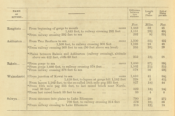
I.--TABLE showing the Fall of the CANTERBURY PLAINS.
* The numbers to which an asterisk has been prefixed are results obtained with the spirit-level, by the Public Works Department.
t The beginning of the pleistocene fan of the Waimakariri lies higher, but the altitude of the junction of the Kowai was the highest datum in my possession, otherwise the result would have been to show a much higher figure, according to the well-established natural laws given in the first chapter.
[Image of page 33]
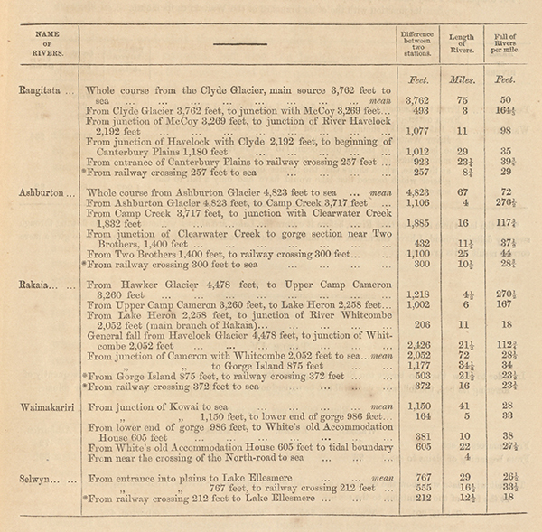
II.--TABLE showing the Fall of the RIVERS of the CANTERBURY PLAINS, from their sources to the Sea, and their intermediate gradients. **
* The numbers to which an asterisk has been prefixed are results obtained with the spirit-level, by the Public Works Department.
** The length of the Rivers is taken by following their general direction.
[Image of page 34]
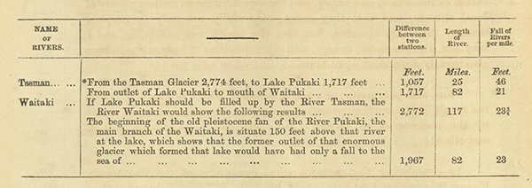
III.--TABLE showing the Fall of the RIVER WAITAKI.
For comparison I may offer the principal data in my possession of the main branch of that River, and after its junction with the other branches of the Waitaki to its mouth.
* As the last three miles of that River, before it enters the Lake, are almost without any fall, it flowing through swampy deltaic ground, I have calculated two miles less for its course than it actually has, so as to give a more correct result of its gradient.
TABLE IV.
In order to show that the larger the River, the greater its power of scouring its channel, and consequently of lowering its bed, the following data will not be superfluous. The Rivers follow according to their volume.
Rivers falling per mile, in feet:--
The following data will show the difference of the fall of the pleistocene Rivers, from the beginning of the plains at the foot of the mountains to the sea:--
But we ought not to lose sight of the fact, that the hardness of the rocks which the Rivers find in their course will cause many modifications, for which we cannot otherwise account. Were not, for instance, the Gorge-hill of the Waimakariri chiefly composed of very hard gritty and dioritic sandstones, which have not yielded so easily to the erosive action of its waters as the looser strata in the gorges of other rivers, this river, according to its size, would have lowered its bed far more than it has been able to do hitherto.
[Image of page 35]
These short notes on the Physical Geography of the Canterbury Plains would he too imperfect did I not offer a few remarks on their climate.
It is needless to observe that on the physical features of a country depends in a great degree its development; that the superficial configuration of mountain, and valley, and the aspect, cause an endless variety of local climate, and that they assist wonderfully not only to people a country favorably situated, but also the health and well-being, and I may add, the character, energy, and other qualities of body and mind are also greatly dependent upon them.
Thus the prosperity of many a country, which is considered to be the result of fortunate circumstances, or even of accident, may be traced by the philosopher to natural causes, principally derived from position and climate.
In considering the meteorological conditions of the Canterbury Plains, it is evident that they would be quite different from what they really are were the barrier of lofty mountain ranges running at right angles to the two prevailing air currents, not placed between the two coasts with such a well-developed longitudinal axis. Instead of the generally fine dry climate which we enjoy on the eastern side of the Island, and a vegetation suitable for the purpose of civilisation and comfort, were this barrier not existing, a great amount of rain would fall all over the Island, a dense and matted forest vegetation would everywhere cover the ground, and the now smiling plains would probably remain for many years to come an untrodden wilderness.
But thus the prevailing westerly winds, which reach New Zealand charged with moisture, which ascend in the equatorial belt, coming in contact with those snowy giants, are deprived of their moisture by the formation of clouds, and their condensation and absorption by the cold surface of these high alpine ranges, and travel on without bringing with them deluging rains.
At the same time, the waters of those inexhaustible suppliers are brought to the sea by our large rivers, bounded for a long time between rocky banks and shingle terraces, and which thus have been and are still not without advantage to us.
If this corollary be correct, we ought with gratitude to look towards the Southern Alps, often deprecated by many a too utilitarian colonist, who considers only the immediate or direct advantage of everything with which he may come in contact.