NOTES TO THE GEOLOGICAL SKETCH-MAP AND SECTIONS OF THE CANTERBURY PLAINS ACCOMPANYING THIS REPORT.
[Image of page 58]
NOTES
TO THE
GEOLOGICAL SKETCH-MAP
AND
SECTIONS OF THE CANTERBURY PLAINS
ACCOMPANYING THIS REPORT.
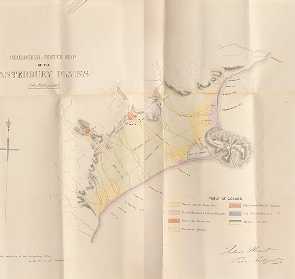
The altitudes in the sections accompanying this Report are, with the exception of those marked with an asterisk, calculated by myself from barometical data. The sketch-map of the Canterbury Plains gives in broad outlines the general geological features of that important part of our province.
To give a map with more detail would involve a larger amount of time than I can devote upon that subject, the object of the geological survey of the Province being less to have a special survey made, which would occupy the lifetime of several geological surveyors, than to have the general geological structure of the Province ascertained and the relative value of each formation fixed.
The Sketch-map of the Canterbury Plains has three principal colours, namely--
1. Green--Pleistocene alluvium, the accumulations of former larger rivers, now scooped out by the present watercourses.
2. Yellow--Recent alluvium, partly derived from the destruction of the pleistocene alluvium higher up the river, or from the disintegration of the Alpine chains, where the sources of the different rivers are situated, and brought down by the present watercourses.
This recent alluvium, by raising the beds of the different rivers and shifting their channels continuously, is depositing new beds over the older (pleistocene) one in some parts of the lower plains.
3. Pink--Raised beaches and estuary deposits, which are either washed away by the present rivers, which form new channels of gravel and shingle in their place, or they are covered by the deposits of these channels without being entirely effaced, or they are still being formed during the present time, making additions to the lower plains, whilst the first one will be gradually destroyed by the action of No. 2, existing watercourses, or the action of the waves as currents of the sea.
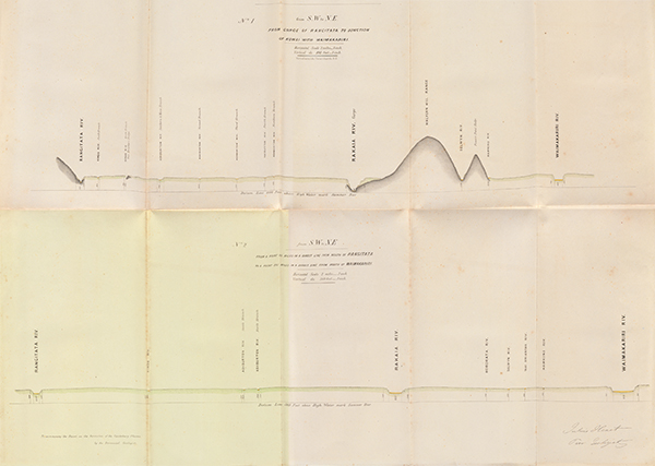
The sections No. 1 to 5 will, I hope, be able also to represent to unscientific persons the structure of the Canterbury Plains.
[Image of page 59]
The Cross Section, No. 1, has been taken from the points where the Rakaia and Rangitata leave the mountains. Not having yet visited the spot where the Waimakariri enters the plains, I could only bring the section to the junction of the Kowai with that river, but consider that it will be sufficient to show, not only the structure of the Canterbury Plains in their upper part, but also to illustrate well the power of the present rivers to scoop their channels through the older alluvium and the rocks lying below it.
It will be seen, that the larger the river the greater has been its power of cutting its channel deeper.
Thus, whilst the Hinds, or some branches of the Ashburton, have done so only for a few feet, the Rakaia has been able to accomplish it for more than 500 feet.
The Cross Section, No. 2, has been prepared by me to show the character of the plains towards their central part.
Here all the rivers are still flowing on pleistocene alluvium; but as the gradient of these older accumulations is greater than that of the present rivers, we are already approaching the line of intersection, where, in several of them, the alluvium of the recent rivers will be deposited over them.
But here the rule still holds good, that the larger the river the greater is its scooping power.
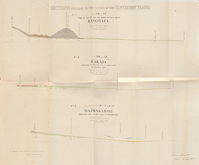
The sections, parallel to the torrents, which have formed the plains under consideration, have been selected so as to show the different characteristics of each of them.
No. 3. Rangitata Section. --This section not only proves that the pleistocene alluvium, in many parts of the plains, continues to the sea through which the river has scooped its channel all the way, but at the same time that these older deposits are met with in a continuous line along the gorges, by which the rivers enter the plains, till we reach the large moraines of former huge glaciers, and of which a beautiful and clear section is exhibited in the valley between Mount Guy and the Ranges bordering the Plains and where it is exposed for about 500 feet vertical height.
The different black lines in the green pleistocene alluvium of the sections 3, 4, and 5, indicate the terraces which become lower towards the sea, till they disappear entirely in the body of the plains.
No. 4. The Rakaia Section shows that the former glacier of pleistocene age advanced into the plains; that when retreating behind this moraine a lake was formed, which became filled up in the course of time by the deltaic accumulations of the river falling into it. In this section the point of change is of importance, when the older pleistocene fan deposits disappear below the accumulations of the present river.
To avoid confusion, I have described raised beaches and estuary deposits as pink, although I should have added also, lacustrine beds, as a large portion of these deposits have accumulated in a lake, separated from the sea by a shingle bank, as Lake Ellesmere is separated from it at present.
[Image of page 60]
As, for instance, what is colored pink in this Rakaia section is mainly lacustrine. Lake Ellesmere, as shown in the Report, having reached so far south, being here filled up by silt, and appearing afterwards above the level of the sea by the rising of the land.
The Section, No. 5, finally, is one of a larger vertical scale than the two former ones in order to give a clearer insight into the structure of that part of the plains, and to show better the relations of the different formations to each other.
Also, here under the head raised beaches and estuary deposits, we have not to lose sight of the fact that lacustrine deposits, similar to those now forming in Lake Ellesmere, are met with; but as these sections have been prepared to give an insight into the structure of the plains, also to unscientific persons, I have thought it necessary to avoid all details of a more strictly scientific character in order to simplify the whole.