[TITLE PAGES]
[Image of page i]
[Image of page ii]
[Page ii is blank]
[Image of page 1]
REPORT
ON
THE HEADWATERS
OF
THE RIVER RAKAIA,
WITH TWENTY ILLUSTRATIONS,
AND TWO APPENDICES,
BY
JULIUS HAAST, PH.D., F.L.S., F.G.S., &c.,
PROVINCIAL GEOLOGIST.
CHRISTCHURCH:
PRINTED, UNDER THE AUTHORITY OF THE PROVINCIAL GOVERNMENT OF THE PROVINCE OF CANTERBURY,
AT THE 'PRESS' OFFICE, CASHEL-STREET,
BY JAMES EDWARD FITZGERALD, OFFICIAL PRINTER FOR THE TIME BEING TO THE SAID GOVERNMENT.
1866.
[Image of page 2]
[Page 2 is blank]
[LIST OF ILLUSTRATIONS]
[Image of page 3]
LIST OF ILLUSTRATIONS.
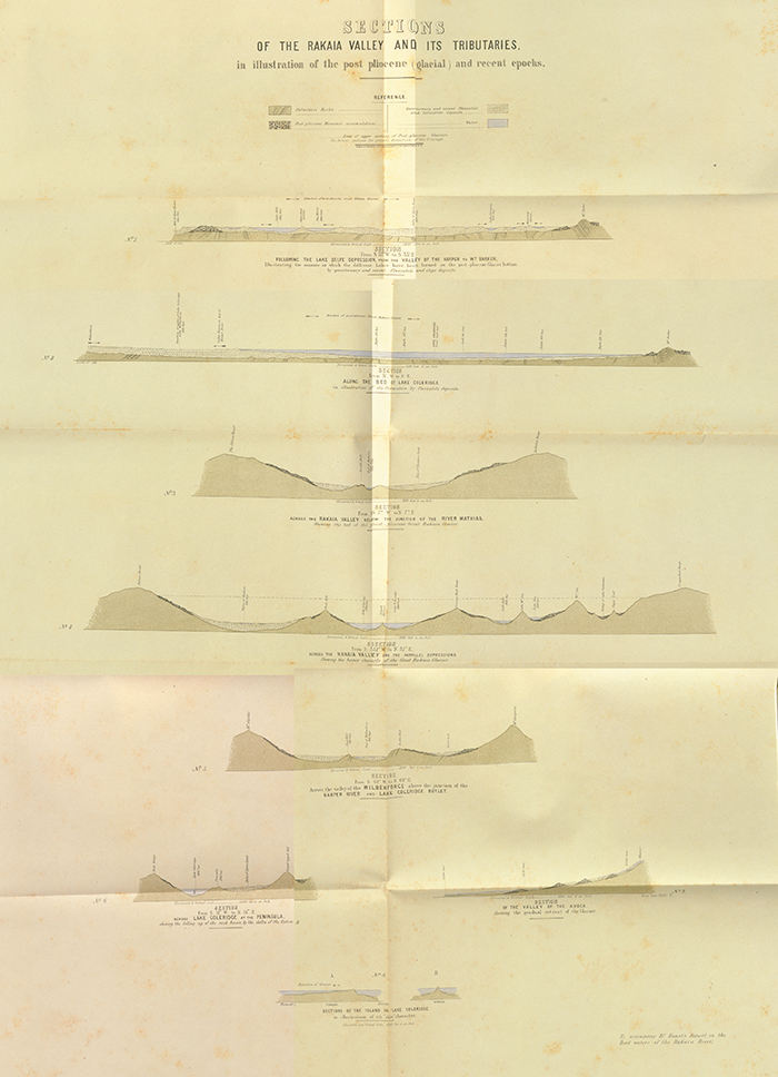
Sections of the Rakaia Valley and its Tributaries, in illustration of the post-pliocene (glacial) and recent epochs.
No. 1.--Section following the Lake Selfe depression, from the Valley of the Harper to Mount Barker.
No. 2.--Section along the bed of Lake Coleridge.
No. 3.--Section across the Rakaia Valley, below the junction of the Mathias River.
No. 4.--Section across the Rakaia Valley and the parallel depressions, showing the former channels of the great Rakaia Glacier.
No. 5.--Section across the Valley of the Wilberforce, above the junction of the River Harper.
No. 6.--Section across Lake Coleridge, at the Peninsula.
No. 7.--Section of the Valley of the Avoca.
Nos. 8 and 9.--Two sections across the Island in Lake Coleridge.
No. 10.--Comparative Diagram, showing sections of the five routes from the West Coast to the East Coast, Canterbury, New Zealand, constructed from barometric observations taken by Julius Haast, Ph.D., F.G.S., &c., Provincial Geologist.
VIEWS.
No. 11.--View towards the sources of the Rakaia, with the Ramsay Glacier, from the junction of Whitcombe Pass stream.
No. 12.--View from Mein's Knob, looking west. The central chain, with the Lyell Glacier.
No. 13.--View from Mein's Knob, looking north. The central chain, with the Ramsay Glacier
No. 14.--View of Whitcombe Pass, from the junction of the Pass stream with the Rakaia.
No. 15.--View of Browning Pass, from the valley of the Wilberforce.
No. 16.--View from the summit of Browning Pass, looking north, with Lake Browning.
No. 17.--View of the headwaters of the River Mathias.
No. 18.--View of Lake Coleridge, from the valley of the Wilberforce, near Cascade Peak.
No. 19.--View of the Sugar Loaves (Roches Moutonnees), from the junction of the Avoca with the Harper, looking south-east.
No. 20.--View of Haast's Pass, looking north.
[Image of page 4]
[Page 4 is blank]