ILLUSTRATIVE VIEWS OF THE CANTERBURY SETTLEMENT.
[Image of page 3]
ILLUSTRATIVE VIEWS OF THE CANTERBURY SETTLEMENT.
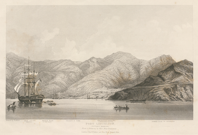
I.
PORT LYTTELTON.
THIS View shows the site of the town of Port Lyttelton, with the hills which separate it from the great plain; the Sumner Road, leading by way of Sumner to Lyttelton, the capital of the Settlement; and the four ships of the first expedition, the last of which, the Cressy, has just cast anchor. Mr. Godley's house, part of the Emigrants' Barracks, the wharves and jetty, and some storehouses and huts, are indistinctly visible. A bridle-path over the hills, the only available road to the Plain when the first colonists landed, may be discerned. Immediately behind Mr. Godley's house and the barracks, is a fifty acre section of land, presented to the College by the widow of the late Mr. Somes, M. P. for Dartmouth, the whole of which is sure to become town land, and highly valuable. This property is given for a scholarship to be named after the founder. At the time represented, the Sumner Road was still unfinished at some places of difficult engineering; and the first settlers, having but just arrived, had erected no permanent residences. At the time of the latest advices (March last), the passengers by the first four ships had selected their rural lands, and the greater part of them had removed from the Port to settle at and near Lyttelton in the Plain. The highest point of land indicated in this view, is Mount Pleasant, 1670 feet above the sea.
[Image of page 4]
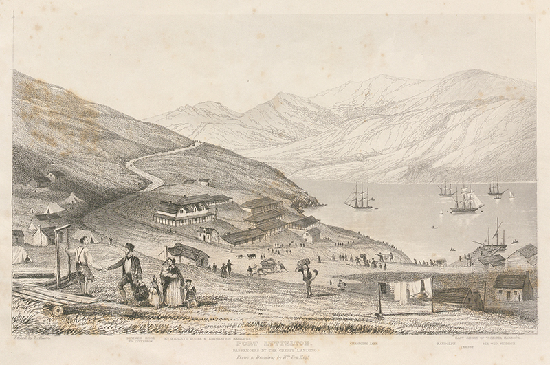
II.
LANDING OF PASSENGERS FROM THE 'CRESSY.'
This Sketch represents Port Lyttelton from a different and much nearer point of view, showing more distinctly the nature of the buildings which had been erected before the arrival of any colonists, and of the sort of places which the first passengers put up for temporary shelter immediately after their arrival. In this View, the shore of Victoria Harbour, opposite to Port Lyttelton, is represented; and the way of exit from the harbour is indicated. The passengers from the Cressy landed eleven days after those by the Charlotte Jane, Sir George Seymour, and Randolph; the three last-named ships having sailed from England on the same day, and entered Victoria Harbour on the same day, after a prosperous voyage of ninety-seven days. They have at the present time (July, 1851) been succeeded by thirteen large ships, making seventeen in all since last September.
[Image of page 5]
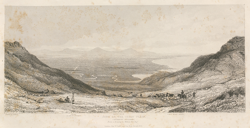
III.
PART OF THE GREAT PLAIN.
THIS View is taken from the highest point of the bridle-path leading front Port Lyttelton to the Plain, about 800 feet above the sea. It comprises a wide space of country, the outline of which is delineated by the 'Forty-miles Beach,' and a mountain range of equal extent. At the time when this sketch was taken, the Plain was a complete wilderness, with the exception of the farm of Messrs. Beans, which is indicated by some smoke at the site of Lyttelton, now the capital town, which at this time (July, 1851) probably contains not less than a thousand inhabitants. But the Plain, being covered with grass, except in the few places where forest is indicated, required no labour to fit it for maintaining live stock; and by the latest accounts (down to March last), horses, cattle, and sheep, in large numbers, imported from the Australias and Van Diemen's Land, had been driven by the bridle-path over the hill from Port Lyttelton to the natural pastures of the Plain. Settlers travelling with their stock are seen in the View.
In order completely to understand the position and extent of land visible at the spot from which this View was taken, it is desirable to inspect the large map of the Settlement, which may be seen at the Colonists' Rooms, 9, Adelphi Terrace, London. The Topographical details of the country in the neighbourhood of Lyttelton and the Port together with the first selections of rural land, are delineated in a map just published by the Canterbury Association, copies of which may be obtained at the Adelphi.
[Image of page 6]
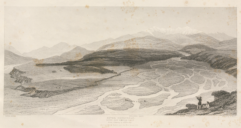
IV.
THE RIVERS COURTENAY AND HINDS.
THE main river is the Courtenay, which enters the sea near the middle of the Forty-miles Beach, delineated in the preceding Sketch. The junction of the Hinds with the Courtenay is at a short distance below the spot where this View was taken, more than thirty miles from Lyttelton. The time was the height of summer, when the bed of the Courtenay, a mile wide at this place, is a dry shingle, intersected by a net-work of streams. These streams are maintained in the driest weather by the melting of snow on Mount Torlesse, but are fordable at some places except at the time of heavy rains. The woods here delineated are of evergreen trees of great size; and they exhibit the general character of the natural forest in New Zealand. Indeed, the present combination of mountain, grassy plain, bright flowing water, and evergreen forest, is highly characteristic of the scenery of the Middle Island.
[Image of page 7]
[Image of page 8]
[Image of page 9]
[Image of page 10]
[Image of page 11]
This day, 3s.; with a Large Map by Arrowsmith, 4s. 6d.
THE SIX COLONIES OF NEW ZEALAND.
BY WILLIAM FOX.
PREFACE.
SINCE the termination of the ten nights' debates on New Zealand in the House of Commons in 1845, and the cessation of the native war which ensued soon afterwards, the public mind in England seems to have forgotten the colony altogether. Any interest which is taken in it seems limited to the movements of the Canterbury Association, or to the Parliamentary Grant, which once a year is made in its behalf, when financial reformers express their astonishment that so flourishing a colony as it is represented to be should require such large amounts of British money for its support. On returning home, after nearly nine years' residence in the colony, I find the ignorance of the many, who know nothing about it, only exceeded by the misapprehensions of the few, who know a little. Under these circumstances, it seems a duty incumbent on me not to keep back the results of my experience.
I left England in 1842, intending to follow the avocations of a private colonist, being a barrister of the Inner Temple, and a graduate of Oxford. In 1843, on the lamented death of Captain Arthur Wakefield, the Resident agent of the New Zealand Company at Nelson, I succeeded him in that office. I held it till early in 1848, when I received the appointment of Attorney-General of the southern province, which I accepted on the distinct assurance that self-government was immediately to be bestowed on the colony. Finding it was not, I resigned; and shortly afterwards, on the death of Colonel Wakefield, the Principal agent of the New Zealand Company, his office devolved on me. It placed me in charge of the Company's interests in the whole of the southern settlements (including New Plymouth), and afforded me the opportunity of becoming acquainted officially and personally with all their affairs. Immediately before leaving the colony, I was appointed Honorary Political Agent in England for the settlement of Wellington. In addition to five years' residence at Nelson, and three and a half at Wellington, I visited Auckland for three weeks, New Plymouth for ten days, Wanganui twice, Otago twice, Canterbury thrice (exploring a large part of the district), and many other parts of the country, where no inhabitants, either European or native, are to be found.
My opportunities for observation, and my inducements to observe, have therefore been at least equal to those of any person who ever visited the colony; and this will, I hope, be held to afford a sufficient excuse for the publication of the following pages.
For the valuable Map which is attached, I am indebted to Mr. Arrowsmith, who obligingly placed the plate at my disposal. It is the only Map of New Zealand that I have met with which is at all complete or accurate; and it brings down the geographical corrections and discoveries to the latest date, being founded on the most authentic, recent, and original documents.
Nos. I. to X. 6d. each, of
CANTERBURY PAPERS:
INFORMATION CONCERNING THE PRINCIPLES, OBJECTS, PLANS, AND PROCEEDINGS OF THE FOUNDERS OF THE SETTLEMENT OF CANTERBURY, IN NEW ZEALAND.
LONDON: JOHN W. PARKER AND SON, WEST STRAND.
SAVILL AND EDWARDS, PRINTERS,]
[CHANDOS STREET, COVENT GARDEN.