[Visits to Maori villages reported by Blosseville]
[Image of page 109]
Rapport d'une Visite aux Villages de Ranghihou, Tippouna & Kidikidi
(Report of a Visit to the Villages of Rangihoua, Te Puna & Kerikeri)
Visite à Payèha, Matowhe & Cororadica (Visit to Paihia, Matauwhi & Kororareka)
JULES ALPHONSE RENE PORRET DE BLOSSEVILLE
A note on Blosseville's two manuscript reports is given in the Introduction (pp 21, 23). A translation into English by Andrew Sharp comprises the immediately following section of the present book.
[Image of page 110]
[Page 110 is blank]
[Image of page 111]
REPORT OF A VISIT TO THE VILLAGES OF RANGIHOUA, TE PUNA & KERIKERI
As Manawa Bay 1 did not offer us the supplies on which we had counted, I was sent with Monsieur Gabert 2 to visit various settlements on the north coast, which we believed to be larger and more amply provisioned. Curiosity caused Monsieur Le Jeune 3 to accompany us. Setting off very early with the large boat, I arrived at dawn at the east end of Motou-Roa, 4 which is surrounded for a considerable distance by large, black, trachytic rocks near which the water is deep but which it is dangerous to approach too closely because of a small rock level with the water. I then made for the bay of Rangihou, situated in the district of hoshi, and seat of the first European settlement, founded in 1815. 5 The coast at this place forms a shallow indentation and gives vessels shelter against all winds but those from the east. Everywhere here one finds four to six fathoms of water, sandy bottom, and the best anchorage is in six fathoms between the NE point of the entrance and a big island notable for its sugarloaf shape, which lies then to the south. The bottom is good and a small brig from Port Jackson tested the full force of the wind there on the first of April without danger. The only hazard encountered in this part as one comes from Point Pocock 6 is a large rock level with the water situated near the coast in the north of the Bay. The sandy shore is broken by a rocky, pointed eminence topped by a hippah fortified by nature, offering the most picturesque view that could be enjoyed in the Bay of Islands. On its right on the slope of a little hill stand four small houses surrounded by courtyards and gardens. Strongly palisaded, they belong to the mission.
We were very well received by the missionaries Messrs King and Hall, who are the first colonists of New Zealand. 7 They have not been discouraged by a residence of nine years, although they have had no success in their apostolic labours and have also not been as fortunate in agriculture as has been reported. In a restricted area of soil, they harvest enough wheat for the two families and have naturalised several European fruit-trees, peach, apple, pear, etc, but according to the experience of these two people the goodness of the earth is seeming only. The hills and mountains are unsuited to cultivation and only the villages enjoy some fertility. As for the natives they have remained so barbarous that
[Image of page 112]
all communication with them has had to be suspended, although even so they have succeeded in committing some thefts. We were dissuaded from taking weapons ashore for fear that they would make an attempt to seize them by surprise. These savages have shown no interest in the mechanical arts which it was hoped they would learn. Nevertheless one sees in the hippah several huts built with planks and painted red contrary to the old custom, but their low shape has not changed and they show no idea of civilisation. Whykato, who made the voyage to London with Shongi and has likewise failed to profit by it, 8 is one of the chiefs of the hippah. When we re-embarked he was sitting on the beach. I approached him making the usual greeting, but he did not get up and scarcely answered me.
Leaving Ranghihou I proceeded toward the south so as to pass through the middle of four small, very broken islands which are no longer inhabited. While going past them I recalled with sorrow that good Tippahi, friend of the Europeans, was living a few years before on one of these islands. Falsely accused by another chief named Tarra of having been the main instigator of the horrible seizure of the Boyd, he saw his hippah attacked by the crews of five English whalers who, to avenge the death of their compatriots killed at Wangaroa, burnt everything and killed without sparing either the sex or the age of their innocent victims. The massacre was horrible, and Tippahi would have been the first to succumb had he not succeeded in saving himself by swimming despite the wounds he had received. One does not know which should inspire the more horror, the frightful calumny of Tarra or the unjust vengeance of the English, but one does not forget that the unworthy jealousy of the one and the bloody fury of the others are traits characteristic enough among their compatriots. 9
We soon entered the vast, safe bay of Tippouna 10 which rivals for quality that of Cororadica and is visited quite frequently by the whalers. The holding there is supposed to be good and yet in all the eastern part which I sounded I found only rock bottom from... to... fathoms. 11 This bay or arm of the sea penetrates two miles into the land and divides to the west into two parts which are the mouths of the Rivers Manga noui 12 (the large branch) and Pokoudo (crayfish). 13 It is separated from the Kidikidi River by the narrow, steep point of Tarriah, 14 near which on a round, high island stands a small hippah.
[Inserted unpaginated illustration]
[Image of page 113]
The boat approached the shore in a shallow inlet at the end of which a pretty stream flowed into the sea, and while the sailors prepared their meal and gathered various vegetables growing wild in the nearby fields, the natives came down from a hippah not far away and gathered round us. Some were armed with muskets and patous-patous, 15 but they did not try to misuse the superiority which an unexpected attack could have given them. Their behaviour was peaceable and the friendship of the women who had accompanied them was a sure guarantee to us that the peace would not be disturbed. Having been no more successful at this place than we had been at Ranghihou in the principal object of our expedition, we left after an hour's rest to go to Kidikidi.
The Kidikidi River up which we went again in the evening is at first only a big salt inlet a mile broad, at the entrance of which is a low island covered with bushes behind which ships can anchor. After three miles the two banks converge and the course of the river narrows as one proceeds, following a deep channel near the left bank. On the swampy margins some scattered huts can be seen. Soon it traces out various bends and the source is reached, or rather the first fall which is six miles from the mouth and beyond which it is often fordable. We arrived at the settlement before night and were very well received there by Mr Clark 16 and Mr Kemp the missionary, 17who offered us his house. As soon as we landed a large number of natives ran up to see us. They were not very bothersome at this first meeting, but to avoid all trouble the sailors did not disembark and passed the night in the boat anchored some fathoms from the shore.
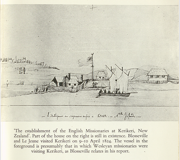
Round a pretty basin, from which the river runs toward the sea after receiving the tribute of several streams, stand the houses of the missionaries who by Mr Marsden's choice established their chief station near Shongi's village. 18 There are six, made of wood and whitewashed; the Minister's is larger and more elegant than the others. 19 They are all surrounded by a wall eight feet high of strong planks, the gates of which, continuously shut by strong locks, reveal the watchfulness of thieves and the curious. Although the outlook is limited on all sides, the situation is pleasant because of the nearness of the water, the depth of which secures the great advantage of making it possible for ships of 150 tons to come up close. On a hill which overlooks the settlement Shongi's hippah is built; it comprises some sixty huts and its position did not strike us as very strong. The chief is accommodated as poorly as his people for in this respect perfect equality is observed in
[Image of page 114]
New Zealand. A house in European style has however been started for him, but the natives refuse to work on it and he himself seems to be little concerned with changing his residence.
The plantations near the houses are fenced, but the fields that have been cleared on the sides of the hills to test the goodness of the soil are not protected by any barricade; these experiments repeated in many places seem to me to prove that the fertility is nowhere notable, but all types of grain are cultivated with fair success. The fruit-trees have not yet had time to succeed; a vine stalk brought from Port Jackson which grew the first year was eaten by a goat and another attempt has not been made. The livestock has acclimatised well and has multiplied; I saw a fine herd of cows, some goats, a horse.
On climbing the surrounding hills from which half the Bay of Islands is seen, the eye discovers toward the interior over a very extensive radius only two small clusters of trees named Pouriri 20 and Kaikatea 21 and the wooded mountains of Wangaroa 22 and Pouke noui (big mountain) 23 show up only at the limits of the horizon. Ferns, the roots of which the natives eat cooked and beaten, alone cover the surface of the ground and there is no indication leading one to think that former forests existed. The soil is well watered by streams which flow in all directions and by the Kidikidi River which, justifying its name, 24 runs from areas of rock and forms several fine cascades. That of Fanafanoua which falls 80 feet is the most notable and its effect is all the more striking because behind the screen of water which shoots out the rock forms a deep cavern, the sombre colour of which contrasts in an extraordinary way with the whiteness of the spray. 25 The natives claim that the lower basin cannot be sounded and they make a god of the rainbow which is often seen above the cascade. Farther off on an arm of the river which comes from the N E another fall of 70 feet can be seen, and a little lower down stands the village of Poukarra Karra which has 200 inhabitants; it is backed by a mountain and bounded by the river. 26 A third cascade 20 feet high is seen a short distance from the houses of the missionaries. The waters which are fairly low rise 13 feet in heavy rains and flood some places. At Kidikidi the settlement is at 9 metres, 27 the waters rise there 8' feet.
[Image of page 115]
The situation of the missionaries seemed to me most precarious. Their safety depends on the friendship of Shongi whose presence assures their protection, and to preserve it they are forced to show a submission which lowers them in the feeling of the natives, whose character disposes them to judge firmness and boldness more favourably than mildness and obedience. Despite his warlike habits the powerful Ariki, so cruel in war, seems quiet and even gentle when the thirst for glory and blood does not animate him. He is a half-recumbent tiger who begins to be weakened by European customs; now on his new expeditions the frugal nourishment which satisfied him formerly appears to him unwholesome and coarse, and in the short intervals of peace he seeks out the table of the missionaries and without proceeding to any excess he then finds English ways excellent. The various authors who have written about New Zealand are not in agreement on the extent of the power of the chiefs; I did not see Shongi exercise his authority, but he seemed to command great respect and walked usually preceded by a man with a pike. As for the customs of the natives I saw nothing which I had not already read in the Voyages of Cook, of Marion, of Nicholas and in Mr Marsden's reports. 28 It remains only to examine more deeply the aim and origin of the customs which these observers have described, and shortness of time did not allow me to take advantage of the society and knowledge of the missionaries whereby this important task should be so easy to carry out.
The practice of the manual arts, the sight of the labours and riches of agriculture, the comparison of the pleasures of civilised life with the crudity of savage manners, have not profited the inhabitants of Kidi-kidi any more than those of Rangihou, and the closer contacts we had with the former served only to give us the most unfavourable opinion of their character. The missionaries sought to excuse them by saying that there were among them a large number of visitors less used to seeing white people. However that may be we could not do any business with them and little separated us from having some vexatious arguments. They tried to take away our trade goods and the sailors had even more to complain about, for they were obliged to defend their food against these barbarous people who had surrounded them like beasts of prey. In 1821 and 1822 some boats of English ships were pillaged in front of the settlement.
I met at Kidikidi some missionaries of the Wesleyan Society established at Wangaroa. One of them, Mr White, had to return there in three days and kindly offered me a place in his boat and all possible facilities for drawing up the plan of the port, which is excellent; I was
[Image of page 116]
to stay at their settlement located on the banks of a river which flows into the harbour and make the journey by land with another missionary from Wangaroa to Kidikidi which is only 24 miles. 29 I hoped I could profit from so advantageous an offer, but unhappily this proposal, which would have given me so much satisfaction, did not gain the consent of the Captain.
At noon we said our goodbyes at Kidikidi, thanking and expressing our regrets to the missionaries, and stopped only at the island which is at the mouth of the river. We were joined there by some canoes which on learning that we had powder to give them for pigs brought us five or six -- and that was all we could procure. We went and anchored afterwards before a little hippah at the east point of Motou-Roa, but we could not get anything there, and saw that everywhere where we had been it was necessary to warn the natives several days ahead, as do the ships which stay at the Bay of Islands and which get their boats to visit the smallest villages. Passing through the small Kent Strait between Point Maricowa and Motou-Roa 30 we arrived on board as night began.
[Image of page 117]
VISIT TO PAIHIA, MATAUWHI & KORORAREKA
On 15 April I set out to visit the fine anchorage of Cororadica which is separated from Paroa by a long, narrow, mountainous peninsula, ending in Point Tapeeka 31 and a chain of rocks visible under the water and very rugged. After stopping at this point I paid a visit to the shell of the Brampton which went aground near the S E coast of the Bay and of which only the bottom parts still remain. 32 This English three-masted vessel commanded by Captain Moore touched while seeking to go out from Cororadica in contrary winds, and as this part of the Bay is the most dangerous because of the bad nature of the bottom, it had to be abandoned. I was told that the captain and crew lived for some time in huts which they built on the island of Motu-Roa while awaiting the arrival of a ship.
I did not find the shoal and breakers marked in Marion's chart, 33 but I did not have the time necessary for exploring this coast carefully.
I got back to the peninsula and crossing the Bay diagonally I arrived at Payeha, 34 where Mr Williams, head of the Mission, lives. 35 His welcome was very friendly, and he seemed to me full of zeal and particularly devoted to the natives. The hastily constructed house is located on quite a fine plain which has been named Marsden Vale, and there is going to be erected a solid building with thick walls, with all the more ease as all the materials are found on the spot. The natives seemed to me very numerous and were not troublesome, but nevertheless Mr Williams is forced to barricade himself like his associates of Ranghihou and Kidikidi.
At the head of the Bay two fine rivers discharge, those of Wai tangi and Cowa-Cowa, 36 the first to the west and the second to the east of Payéha. That of Cowa-Cowa, the larger of the two, is navigable for small vessels for a good distance from its mouth. It is by this that the fine building timbers in the interior are brought down; bought cheaply they are loaded for Port Jackson in English ships.
North of Payéha is the cove of Matowhe 37 at the head of which Mr Kendall lives. I was very sorry not to find him at home. I expected to find him better established than his associates, but I saw several workmen engaged in the construction of a new house. Mr Kendall has
[Image of page 118]
behaved with more tolerance and talent than the other missionaries. He has respected the opinion of the natives without showing distaste for their customs, and he owes to this conciliatory behaviour the consideration and freedom which he enjoys. He is not obliged to be on his guard and neither walls nor palisade are seen round his dwelling. The bay of Matowhe is semi-circular and can hold small coasting vessels. The country seems well populated although the inhabitants are at the war with Pomarre.
Sailing along the coast toward the west I passed in front of the fine, sandy cove which properly bears the name of Cororadica, at the head of which several huts and a small hippah are seen. It is in front of this cove that the ships anchor in six fathoms sandy bottom in full safety. I again rounded Point Tapeeka and soon arrived at Manawa.