CHARLES HEAPHY (1820-81)
[Image of page 186]
CHARLES HEAPHY
(1820-81)
CHARLES HEAPHY was nearly twenty years old when, in 1839, he came to New Zealand in the Tory with Colonel Wakefield, who was to select and buy land for the New Zealand Company's first and principal settlement, Wellington. Heaphy came of a painting family, and he had studied painting and map-drawing. He was official artist and draughtsman to the Company for three years, and his lithographed watercolours, at once precise and stylized, must have helped the Company authorities and the public towards an awareness of New Zealand scenery and settlement. In 1841 he went to England as courier to the Company directors, and while there wrote A Narrative of a Residence in Various Parts of New Zealand, an optimistic but informative account of the country's geography, native people, and the various settlements, with a noticeable Company bias. Returning to Nelson early in 1843 he tried farming at Motueka for a year, and in the next four did various explorations and pieces of survey work for the Company in Nelson. His accounts of his explorations were published in the Nelson Examiner and some appeared in the New Zealand Journal, the Company's paper. The longest two are republished here, from the Nelson Examiner.
Though Heaphy continued to travel during thirty-five strenuous years, he did not publish accounts of any more journeys. In 1852 he joined the Survey department at Auckland, rising from draughtsman to chief surveyor. He had a few months as commissioner of the Coromandel gold-field (for which he long cherished expensive hopes), a year's soldiering in the Maori wars, two years in Parliament, and finished up as a Native Reserves commissioner and judge of the Native Land Court--high-sounding responsible offices with the meagre salaries of a young, struggling colony.
The peak of his public career was his Victoria Cross, gained in 1867 by bravery under fire in 1863 and patient solicitation afterwards. It was the first time this award was made to a colonial soldier not a member of the British regular forces, and persuasion was necessary. As New Zealand's first V. C., Heaphy is still remembered slightly. But in the last decade or so his paintings have won fresh acclaim. A few have been reproduced anew, and again appear on house walls. Only those of his early years in New Zealand are well known, and it is not clear how much painting he did afterwards.
[Inserted unpaginated illustration]
[Image of page 187]
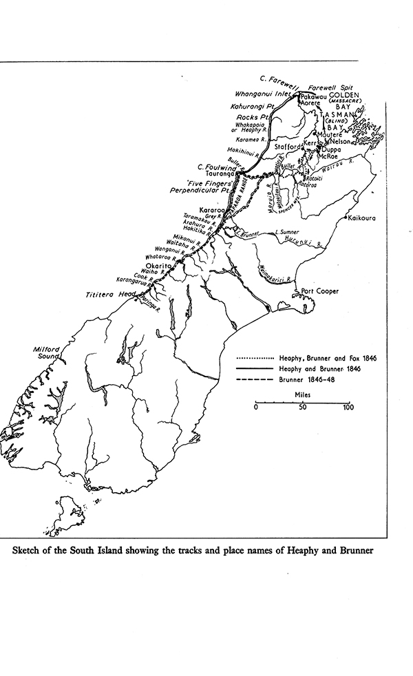
Expedition to the South-west of Nelson
In 1846, however, when, with Thomas Brunner, who was to make the greatest single journey in New Zealand, and William Fox, who was to win the successes of money, knighthood, and premiership, Charles Heaphy set out for the steep bush hills of south-west Nelson, the years ahead were as unknown as all that lay beyond those hills. No doubt Heaphy was as hopeful of the future as he was of finding the large level lands, inviting settlement, that Nelson so badly needed. For he was a lively young man, anxious to make good stories of good adventures and good pieces of exploration.
The first trip given here, from Nelson to Rotoroa Lake and the middle part of the Buller River, in February 1846, with Fox, Brunner, and the Maori Kehu, was evidently something of a picnic. Its account, written with exuberance at times almost awkward, was published in the Nelson Examiner, 7 and 14 March 1846.
The second journey, with Brunner, Kehu, and another Maori, from Massacre (Golden) Bay, round the west coast as far as Arahura and back, between March and August 1846, was a much longer and sterner affair. Heaphy reported it, with only occasional flippancy, in the Nelson Examiner, 5 September-17 October 1846. It is hard to disagree with Fox, then the New Zealand Company's agent at Nelson, who wrote of it to Colonel Wakefield, the Principal Agent, 'I think Messrs. Brunner and Heaphy are entitled to the credit of having accomplished the most arduous expedition which has yet been undertaken in New Zealand, and to much praise both for the enterprise which dictated it, and the courage and perseverance with which they carried it through.' 1 He added that he thought it a proper memorial to their exertions to affix Heaphy's name to the Whakapoai River (where it has remained) and Brunner's to the Arahura; but here the Maori name, so famous as that of the source of greenstone, has rightly persisted, though Brunner's name is now perpetuated by a lake, a town, and a mountain range. Certainly it showed enterprise, almost impatience, to set off for the west coast in autumn, and perseverance is not too large a word for the quality that kept them pushing southwards past their first objective, the mouth of the Buller. Probably they simply felt that having come so far they might as well go a bit farther and trust to luck. The abiding wonder is that Brunner, after such experience of hunger and weariness, could tackle the job once more a few months later. One can only remember that polar explorers have gone back again and again to their icy tasks.
It seems right that this journey should appear here beside Brunner's more famous one. There is some similarity, but it is not repetition; and Brunner would not have described the storm at
[Image of page 188]
Cape Farewell, nor sung the praises of the weka. Heaphy's geographical descriptions are clear, his remarks on Maori history on the coast have been of lasting interest, and as the New Zealand Pilot (1856) records, from the map made by Brunner and Heaphy a great deal of coast-line detail between Bold Head and Cape Farewell (180 miles) was adopted in the survey of H. M. S. Acheron in 1851, which was the most reliable plan of the coastal area for a long time.
Some sixteen years later Heaphy published a much shorter account of this journey as 'A Visit to the Greenstone Country' in Chapman's New Zealand Monthly Magazine, of October and November 1862. Here there is less verve and gusto, and in proportion more of packs, cliff-climbing, food-contriving, and weariness, as well as more about greenstone. The main supplementary details have been added here as footnotes.
Account of an Exploring Expedition to the South-west of Nelson
In consequence of it having been reported by the natives who returned from the interior last winter, that an extensive and available valley existed upon the river flowing from the large lake, 2 and that it was accessible from the Nelson district, I determined, in the early part of the summer, to make an excursion as soon as the dry season might be expected, in order to ascertain the nature of the country to the south-west beyond that which had been before explored, and to find, if possible, a practical route to the West Coast in that direction.
The same objects had likewise determined Mr. Fox and Mr. Brunner to undertake an expedition to explore towards the same point; and as the route of both parties for the first fifty miles must be the same, we agreed to proceed together to the Rotuiti Lake, 3 where we intended to make a depot of provisions, which would enable us to penetrate the farther country to a much greater distance than had been attained on former expeditions.
[Image of page 189]
Expedition to the South-west of Nelson
The party, consisting of Mr. Fox, Mr. Brunner, and myself, with E Kehu, 4 a native who had last year visited the large lake and adjacent country, and who had been engaged by Mr. Fox as guide, left Nelson on the 2nd of February, and arrived on the 4th at the edge of the great wood in Munga Tawai Valley, 5 to which point our provisions had been carried by two horses, furnished by Mr. Fox for the purpose.
As the distance which we attained exceeded that of any previous expedition in New Zealand, in which, travelling through an uninhabited country, the party had to depend entirely upon its own resources, it may not be irrelevant to mention the manner in which we provisioned ourselves for the trip:-- 2 cwt. of flour, with a sufficiency of bread for immediate purposes, promised sustenance for four persons for at least a month; 24 lbs. of sugar, with tea and coffee in proportion, and about 20 lbs. of ham, constituted the creature comforts, to the mention of which may be added that of half a bottle of whiskey, taken, of course, for medicinal purposes. A sufficiency of large shot, for water-fowl, had been left on a former excursion at the Rotuiti Lake; and with 2 lbs. of powder and a double-barrelled gun our sporting equipment was complete. Dangling to the load of one of the party was a large tin saucepan, which had seen some previous service, while another carried an axe, and a third a small tent for the shelter of the baggage. Each had with him a blanket and a few necessary articles of clothing; and distributed amongst the party there was fortunately that happy versatility of talent which enabled it to boast of a 'good plain cook', a first-rate tailor, two glee singers, and a dispensing physician.
Thus excellently equipped, we divided the whole equally amongst the four, and on the 5th, the horses being sent back to the Waimea, we started into the 'big wood'; each having a load of 75 lbs., without a prospect of its materially diminishing for four or five days.
The appearance of one of the party, with his immense burden, forcibly reminded one of a grotesque Atlas; while another, with his small body and topping load, suggested the idea of an overgrown and peripatetic mushroom; any allusion to amateur ticket porters
[Image of page 190]
would at the time have been considered personal, and met with adequate resentment.
The travelling in the 'big wood' is of the most laborious kind to a person heavily laden, as, although almost free from underbrush, the ground is covered with wet moss, into which the leg sinks occasionally to the knee, and the path is frequently impeded by dead timber and thorny brambles, upon which but few blessings are evoked by the traveller. After walking about three hours, and getting over as many miles, we were forced to encamp by rain, and remain during the rest of the day under the shelter of a blanket.
6th. Fair weather. Proceeded along the usual track towards the Wairau Pass. Derived considerable amusement from contemplating the helpless situation of any unfortunate individual who, having lost his erect posture, and being wholly unable to divest himself of his load, which was carried before and behind, could no more recover his perpendicular without assistance than a dog could disencumber itself of a stone hanging round his neck. A decided disinclination manifested to remaining any considerable distance behind.
In the course of the day passed the round mountain and the Wairau opening, 6 and, having travelled about eight miles, encamped, still in the wood.
7th. After continuing on for three miles in a S. S. E. direction, over heavy mosses, reached the open space before the Rotuiti Lake, and dined: after making sketches, proceeded on to the lake and encamped: distance, six miles.
The water in the lake was lower than on either of my previous visits, giving indication of an easy fording of the river, which had always before been an obstacle to exploring to the southward. We found the shot which I had buried last year; 7 and the number of birds which were about promised more use for it than we had found when I had left it behind on that occasion of visiting Lake Arthur. 8
8th. Proceeded down the grass valley about three miles, and found that the Aglionby, 9 as we denominated the river which flows from the lake, would admit of our crossing, its waters being unusually low: its rapid current and rocky bed, however, rendered it necessary
[Image of page 191]
Expedition to the South-west of Nelson
for us to examine several of the rapids before we could determine at which to cross, and the fording, though accomplished in safety, was not unattended with considerable risk.
From the ford we proceeded about a mile further down the valley, and encamped in a manuka grove near the river side.
9th. It became evident that the native who was with us intended penetrating the wooded country to the south of the grass valley by going up the stream which flows into the Aglionby at the termination of the plain, and which in a former expedition I had named the Howard. This was precisely the route I had intended to take in order to reach the Roturoa lake, and which I have no doubt we should have found without his guidance. The more distant valleys of the Tiraumea and Matukituki we should not so easily have reached. Encamped on manuka hill above the Puawini or Howard, which we reached after a walk of seven miles along the grass valley, on a course of W. N. W.
At the place where we halted were the remains of several bark huts which had been built by former natives from Blind Bay 10 during the inland excursions they had been in the habit of making after the now nearly extinct birds, the kiwi and kakapo. The tribe of Ngatitumatakokiri, to which those people belonged, was the most powerful on the north end of the Middle Island; and was located from the Pelorus river to the Motuaka, 11 Massacre Bay, 12 and the western coast, the principal pas being in the Waimea, 13 on the sandflat near the snapper-fishing ground at Wakatu, 14 where the trenches are still observable, at the Moutere, and at Kaiteriteri. From these several places the inhabitants were driven inland by the Taranaki tribes, assisted by Rauparaha; and at the termination of the war only three men remained of the tribe; they being E Kehu, our guide, Pikiwati, 15 who accompanied the late Mr. Cotterell 16 on his expeditions, and another, a slave at Motuaka.
The cultivations of the natives of this tribe were very few, as they
[Image of page 192]
had not obtained the potato before their dispersion. Dissimilar, in consequence of this, to the generality of the natives of the Middle Island, they were well acquainted with the interior of the country, where, in fact, half their time was passed in the search for birds and eels. E Kehu, our guide, is thus a perfect bushman, and is of very great service on an expedition; he has none of the sluggishness of disposition so common to the Maori, but is active and energetic, displaying far more of the characteristics of the Indian savage than are to be seen in the usual lazy inhabitants of a pa; 17 thoroughly acquainted with the 'bush', he appears to have an instinctive sense, beyond our comprehension, which enables him to find his way through the forest when neither sun nor distant object is visible, amidst gullies, brakes, and ravines in confused disorder, still onward he goes, following the same bearing, or diverging from it but so much as is necessary for the avoidance of impediments, until at length he points out to you the notch in some tree or the foot-print in the moss, which assures you that he has fallen upon a track, although one which he had not been previously acquainted with. A good shot, one who takes care never to miss his bird, a capital manager of a canoe, a sure snarer of wild-fowl, and a superb fellow at a ford, is that same E Kehu; and he is worth his weight in tobacco!
10th. We this morning commenced our exploration, having been until now upon a known route. At our last night's encampment we left thirty-five pounds of flour, with other provisions, for our return, and for the first time had our loads materially lightened. To outwit his old enemies, the rats, E Kehu buried the provisions, nicely lining the hole with bark, and covering the place over with ashes; a proceeding which we certainly should not have decided upon for security against burrowing animals, but which he knew was effective.
We proceeded up the bed and shingle banks of the Howard, taking its right branch, and travelling among some highly picturesque grass and manuka ridges on a course to the S. S. W. for the Roturoa lake, between which and our dining place our guide informed us was a very high hill, which we must ascend that afternoon or the next morning, and the clambering of which would cause us to be matemoi, or 'kilt' with the fatigue of carrying such loads as we still had. The
[Image of page 193]
Expedition to the South-west of Nelson
better to make us understand his meaning, and for the purpose of illustration, he would, in mimicry of one of us, pretend to take a few steps up a steep acclivity, then suddenly stop to take breath, and supporting himself with his hands on his knees in a stooping attitude, would look with most rueful countenance upward, gasp a little, make a desperate rush onward for a few steps, and fall as if exhausted, saying in conclusion that the mountain was 'no good!' 'too much!'
With this pleasant prospect before us we left the stream at about three miles from our last encampment, having made an early dinner in consequence of being assured that we should meet with no water on the mountain, and commenced the ascent of the wooded mountain to our right, still keeping much the same bearing of S. S. W. The forest was of black birch, 18 almost the only timber in these high elevations, nearly devoid of underbrush, and the ascent steep only in places occasionally, but still long and wearisome, still upward and upward! But this was not E Kehu's 'big hill', only a little one in comparison to it. 'By-and-by, you see', was the consoling answer to all our interrogatives as to when the ascent of the main ridge was to be commenced, until at length, when we appeared to have reached the elevation of the highest hills around, our guide told us to halt; he had circumvented the 'big hill', and we would have no farther to ascend. He had, in fact, found a new ridge by which to gain the summit of the mountain-range, and, by heading a deep ravine, had avoided the necessity of descending into the hollow and reascending its opposite side. The distance travelled this day from the grass plains was about eight miles, and the path one along which pack mules might be taken without much difficulty.
11th. After walking about a mile this morning we perceived that the greatest elevation had been attained; and the native, pointing downwards, showed us the lake of the Roturoa, which appeared indistinctly through the foliage, far beneath us. We hurried down the steep ridge to the lake, occasionally catching glances of various parts of the long expanse of water through the birch forest as we descended.
Similar to the Rotuiti, the hills at the large lake descend steeply to the water's edge on both its sides, leaving but occasional shingle beaches along its margin.
The lake appeared about twelve miles long, with an average
[Image of page 194]
breadth of one mile. The point at which we had come upon it was about a mile and a half from its north-western extremity, whence flows the river Gowan to its junction with the Buller, 19 or large western river, which descends through the Devil's Grip 20 and grass valley from the Rotuiti lake. After receiving the waters of the Gowan, the large river keeps a mean course of W. S. W., and having been augmented by the waters of the Tiraumea, Matiri, and Otawpawa, 21must meet the sea at the south of Cape Foulweather. 22
Just at the spot at which we had come upon the lake, and under some bushes, was a small canoe, which had been constructed by the natives when at the Roturoa last year. It was speedily launched, and, with ourselves and our packs, was so loaded as to render it doubtful whether we could cross the lake in it without its swamping. Away, however, we paddled, being obliged to observe the greatest nicety of balance to prevent oversetting; for the canoe being a tiwai, or one without top-sides, took in the slight ripple to windward; and as we looked down and caught sight of the rocky bottom of the lake, some forty feet below, which we could see through the transparent water, thoughts arose concerning the impropriety, not to say inconvenience, of leaving our bones in such a locality.
Certainly it was a new method of exploring, and we enjoyed the ease of it exceedingly. As we left the shore the whole expanse of the lake became visible, with its densely wooded shores, and the high snowy mountain range at its head, in its wild grandeur, closing the view. Grebes and divers, with other water-birds, were floating about on the surface, nor did the instability of our shallop deter us from getting a shot at them. Then away would rattle a flock of wild-fowl, their noise being the next moment followed by the various echoes of the report reflected back from the hills.
The native now allowed the canoe to glide down with the waters of the Gowan where they left the lake, and we passed rapidly beneath a handsome white-pine forest on the river-bank; immediately after which the canoe was put in towards the northern bank, and we landed on a grassy opening of about thirty acres, surrounded by black birch wood and manuka. Here the natives had formerly
[Image of page 195]
Expedition to the South-west of Nelson
built a house, and endeavoured to grow some potatoes on a small patch of cleared ground, where, however, the rats soon ate the seed. It was one of their favourite eel-fishing stations, and we had every prospect of an abundance of excellent provisions from the lake and river, during our stay at the Roturoa.
We encamped on the immediate edge of the river; and as soon as dark two of the party, with E Kehu, took the canoe to the opposite side of the river, where, mooring it to a flax bush, they commenced fishing, or, more properly, endeavouring to fish, for between the two they found a wide difference. The Maori watched the eels at the bottom, and putting the bait in their way, had them the next moment in the canoe, splashing the more unfortunate sportsmen who still had nothing but nibbles. After supper, when we had relinquished the sport, he re-crossed the river, and to dispel all feelings of lonesomeness, commenced chanting his Wesleyan missionary service, mixing with the translated version of the ritual special incantations to the taipo 23 of the lake and river for propitious weather and easy fords, together with requests to the eels to bite quickly, and not keep him longer in the cold. Then, as he caught one which would not die quick enough to please him, would he introduce some decidedly uncomplimentary language which he had learned at a whaling station, and again subside into the recitation of his Wesleyan catechism and hymn-book, bringing in our various names in the versification. He did not leave off until long after we were asleep; and in the morning when we awoke, four fine eels were roasting for our breakfast, and another four were hanging from an adjacent tree.
12th. Having determined to spend a day at the Roturoa, we commenced equipping our canoe for the intended trip along the lake. Three paddles were quickly cut out of a tree, and we started for a day's pleasuring on the 'large lake', or, as we named it, Lake Howick. Forcing the canoe briskly against the strong current of the river, we were soon past its influence and on the still water of the lake. Landing the native on a fern-hill, near the Gowan, for the purpose of shooting pigeons, we proceeded in the canoe along the southern side of the Howick, paddling close to the overhanging forest of birch and rimu which covered the adjacent hill-sides and reflected its beautiful foliage in the still lake. The motion of a canoe is not unsuitable to the proper enjoyment of such a scene, nor
[Image of page 196]
is the labour of paddling such as to cause fatigue. Occasionally would we dash along to the time of some animating chorus, and then, withdrawing our paddles, suffer the canoe to glide silently past a point beyond which we should obtain a new and more extended view of the lake. At other times we would steer out into the middle of the lake, endeavouring to near a grebe, or seeking for a fresh point of view for sketching the surrounding shores, discussing the while the practicability of ascending at some future time the great chain of the 'Southern Alps', 24 which tower[s] over the eastern end of the Howick, and divides it from the Rotuiti and Port Cooper25 countries.
At a small beach, about six miles from our morning's encampment, we landed for the purpose of cooking our dinner, which consisted of a pigeon and some damper. Discussed the probability of the Howick becoming the future resort of East Indian diseased-liver invalids; of the propriety of having pleasure-boats on the lake, with a tontine 26 hotel at the Gowan, and mules for excursions to the surrounding mountains and points of view. Spirit of Picnics, here should thy temple be.
Before our dinner was well over the heavy clouds gathering over the lower end of the lake warned us to hasten our return; and before we had paddled a mile on our way back, the wind had increased to such a degree that, with our heavily laden canoe, the 'sea' which arose added neither to our pleasure nor safety. We, however, crept along close in shore, putting her bow on whenever the waves were threatening, and at length reached our new encampment, which we had formed on the southern shore, in order to be ready to proceed at once on our way to the Tiraumea on the next morning. On our way back we landed for E Kehu, whom we had left on a fern-hill to shoot pigeons, and who had killed six and a woodhen.
In the course of a day and a half we obtained at the Roturoa, without any trouble, 6 pigeons, 4 blue ducks, 10 eels, and 4 wekas or woodhens, the last being snared by the native. The method of catching these birds is singular and amusing. The native, when in a locality which he thinks likely to be frequented by woodhens, imi-
[Image of page 197]
Expedition to the South-west of Nelson
tates, with a whistle made of a flax-leaf, the cry of the bird, which somewhat resembles the call of a partridge. If one be within hearing it will answer, or more generally several will respond to the cry, and the native, listening for a moment attentively, informs you of their number and position. Breakfast or dinner may then be cooked and disposed of, the wekas, saving the trouble, being as good as caught, and forming an exception to the rule contained in the old proverb of 'a bird in the hand', &c. When at leisure, the Maori provides himself with two slight sticks or canes, of the lengths of about four and six feet. To the end of the shorter he attaches a bunch of feathers, or even leaves, and to the longer a small running noose of flax, and with these proceeds in the direction whence the sound came. When he considers himself near enough he stops, and crouching down amongst the underwood, but without caring to be concealed, imitates the more familiar call of the bird by a peculiar grunting sound made in the throat. In a short time the woodhen appears, and the native rustles the feathers at the end of his stick, making a chirping noise in unison, and the weka, mistaking the moving object for a bird, is led by the pugnacity of its disposition to attack it, in advancing to do which the noose is quietly put over its head, and with a jerk upward it is caught alive. An amusement with which were the editor of Punch acquainted, he would not fail to recommend for aristocratical diversion in the royal preserves and poultry-yards.
13th. Laundry work disposed of; fine 'drying weather'. Proceeded from our encampment on the Roturoa for about three miles in a S. S. W. direction, through a pass towards the Tiraumea valley, which was the next locality to be visited, when we were obliged to encamp by a change in the weather. Put up a blanket house, which we subsequently considerably enlarged and improved by adding to it walls and back of bark stripped from the surrounding birch trees. Amused ourselves with the pursuit of comfort under difficulties.
14th. Fine. After ascending slightly for about a mile, found the water flowing to the southward, and proceeded down a ravine to the S. W., walking in the bed of the stream or through tangled underbrush for about six miles, at which distance we emerged upon a grassy valley of inconsiderable extent. Walked on through deep swamp-grass and in the river-bed for two miles more and encamped; the principal valley of the Tiraumea being about two miles and a half to the southward, and a high, bare-topped mountain, called by
[Image of page 198]
the natives Tahuatao, 27 visible through an opening due north. From this mountain the Rotuiti and Nelson countries can be seen, and it immediately overlooks the course of the Buller, or 'large western river', through the Devil's Grip and its continuous gorges.
15th. Walked two miles and a half down the bed of the stream to the open part of the Tiraumea. This valley, or rather series of valleys, was the first open or available country which we had seen since leaving the Rotuiti plain; the intervening country being, in the more elevated situations, covered with black birch forest, and lower down, as on the shores of the Roturoa, with that wood, manuka, and the various pines; the whole extent being of such a hilly nature as to render it unfit for cultivation.
The principal valley of the Tiraumea is covered with grass for about six miles above the confluence of the three streams which form the river of that name; 28 beyond that distance it becomes wooded, and continues winding between the hills in a direction S. E., towards the Otapawa valley of the Matukituki, 29 with which it probably communicates. The other valleys, which diverge to the east and north, are inconsiderable in extent, but uniting as they do at a common point, form a pretty grass flat of capital pasturage ground, of about 4,000 acres, with some good bush land exclusive. The sides of the valley display similar terraces to those in the Motupika 30 and Rotuiti valleys, and which appear to have been formed by the subsidence of former lakes, the waters of which have found an outlet by the gorges of the Matukituki.
16th. The Tiraumea river, flowing to the west, enters a narrow wooded valley about two miles below the junction of the minor valleys on the grass flat. Our route lay down the rocky bed of the stream, which had to be crossed every 200 or 300 yards, the depth of the water at the fords being from two to four feet, with a rapid current. Great quantities of blue ducks, apparently a species of shoveller, are to be met with on this stream, and would afford
[Image of page 199]
Expedition to the South-west of Nelson
excellent sport to retrieving water-spaniels, as some of the party can testify from practical experience.
In the afternoon passed the Mai, a very pretty waterfall, formed by a tributary stream from the southward falling into the Tiraumea over two ledges or rock steps from out a beautiful wooded glen. Up this stream the bush natives used to go for the kakapo, now nearly or quite extinct. This bird, of which no perfect remains are extant, appears to have been a ground parrot of a larger size than the kaka, and with beautiful green and white plumage. It was formerly to be met with abundantly in this district, as also in other parts of the island, and the natives attribute its extinction to the wild dogs. The European rat, which has spread over the whole of the country, in my opinion is more likely to have been the cause, destroying as it would the eggs and young in the lowly situated nests of the kakapo and kiwi, and, in all probability, of the moa also.
Slept on a sandy beach on the northern bank of the Tiraumea. Distance, six miles.
17th. Followed the river down in a general westerly course, the stream becoming considerably increased by the accession of tributaries and the fording more difficult. At five miles and a half came upon its junction with the River Buller, which flows down from the lakes, receiving the waters of the Gowan and the river formerly denominated the Fox. 31 About the lower part of the Tiraumea, between the bends of the river and the mountain, are some good flats of forest land, containing each an average of perhaps 50 acres, the soil undoubtedly good, and the timber not what is usually called heavy. It must be included, however, in the Matukituki country, and the valley, with the upper or grass valleys, does not naturally belong to the Nelson district.
The appearance of the River Buller, at the point at which we came upon it, is singular and remarkable. It flows through a wooded valley of about half a mile in width, down the bottom of which it has hollowed its course, amid high and uncouthly-shapen masses and piles of rock, divided as if by some earthquake force, and worn smooth by the mighty and ceaseless action of the river. Twenty miles above this spot the rapidity of the current is such that to ford it would be not only impossible, but either man or other animal that might venture within its influence would be immediately
[Image of page 200]
dashed to atoms; while here in its deep channel the river slowly moves along, a dark mass of water sixty feet from the bottom to the surface.
Encamped among the rocks about half a mile below the junction of the Tiraumea, or the Mangles, as we named it, with the Buller; the opening of the Matukituki appearing about a quarter of a mile lower down the course of the river.
18th. Below our encampment about a quarter of a mile the gorge terminated, and the valley of the Matukituki commenced in an expanse of open manuka country, with pine forests and fern flats on either side of the Buller; several wooded valleys appear to join the main opening a mile or two down the plain. The scenery exceedingly picturesque.
The 'big river' was now to be crossed: from the wooded terrace above, it appeared but a couple of feet deep, and its fording seemed easily practicable, but from its beach the appearance of the large body of water which rushed down became more formidable, and each instinctively hesitated before advancing into the stream. For about thirty yards from either shore the water glides smoothly along, with a current one might undoubtedly bear up against; but in the centre it rushed with impetuosity in a deep, hollow wave to its greater velocity below the ford, where it became a race crested with a high and broken ripple.
The native looked at the river, made one of his comical grimaces, and entered the stream, the depth of which now became apparent, and ere he had reached the centre of the river the water was up to his waist. One or two of the party now ran down the side of the river, in order to be able to afford assistance should he be carried down; but with once or twice staggering when exposed to the greatest pressure, and a spring downward with the current as he neared the further bank, he reached the opposite side in safety, not forgetting to evince his contempt for the river and exultation at having crossed, in a series of grotesque gesticulations and vehement abuse of the river and all its tributaries.
Mr. Fox now followed into the stream, and attained its centre without much difficulty, but the pole which he used bent under him while bearing against the heaviest rush, and it was a matter of critical uncertainty as to whether he would attain the bank which he was approaching; a few steps more and he would be past the worst of the current, when he appeared for an instant to totter, and the
[Image of page 201]
Expedition to the South-west of Nelson
next moment was swept down the race entangled with his load. Fortunately the river was deep, or the consequences would have been fatal. 32 Recovering a swimming position, he swam to the further shore, and was in a short time across, which, however, were not the remaining two of the party, whose spirits were not at all elevated by the fortune of those who had gone before them. Mr. Brunner determined to follow down the river to a better ford, where the water became more expanded upon the plain, and I swam over above the ford, where the current was less rapid.
During the remainder of the day proceeding down the open valley, crossing the river three times, at long but fair fords, at one of which we were found by Mr. Brunner from the south side. Slept in a totara wood on the left bank.
19th. Proceeded down the Matukituki, or Aglionby valley, to near the point at which it again narrowed to a gorge, and flowed to the westward among high mountains, which we were not at such a distance from the settlement eastward to traverse, more especially from the worn state of our shoes, which, with so much river walking, were in a very precarious condition. At this point, I believe we must have been about twenty miles from the west coast, and from the distance travelled to the south-west, it appears that we must have been even with the embouchure of the 'Rapid River' of Cook, and which is most probably the Buller. The level land reported by Toms, the sealer, 33 is in this latitude, and the river which he proceeded up for three miles is perhaps the same as the one we had followed from the lake.
20th. Returning along the course of the Matukituki, crossing the main river twice.
21st. Returning up the Tiraumea, and during the 22nd, by the upper valley of the Tiraumea.
23rd. Continuing up the bed of the Tiraumea, being our eleventh day of river wading.
24th and 25th. Between the Tiraumea and the Rotuiti valley nothing of importance occurred, except the finding of half a bottle of whiskey, in good order, at our depot at the latter place, and drinking the same. The flour and other provisions which we had buried, we found in excellent order; and although we had all the time had a
[Image of page 202]
plentiful sufficiency of provisions, we now had actually more than we could consume on our way to Nelson.
26th. Crossed the Rotuiti river. 34
27th. Were guided by the native along his old track through the big wood to the Motupika valley, avoiding the Mungatawai valley at the Wairau pass; the new track saving a distance of ten miles in the journey.
28th. Down the Motupika to Mr. Stafford's sheep station 35 in the Motuaka valley, where we were most kindly entertained by Mr. Frazer.
March 1st. Walked into Nelson.
The Matukituki or Aglionby district, is formed by the junction of two considerable valleys with that of the Buller, at a point where the gorge of that river terminates and its waters expand in a fine fern and pine covered valley, which in five or six miles again becomes a gorge, and winds with the river flowing down it to the western coast.
The main opening or that on the immediate banks of the Buller is about two miles wide, and consists of fern flats, manuka scrubs, and pine forests, in which the totara and kahikatea seem to predominate. Midway between the two gorges of the Buller, the Otapawa valley joins it from the south-east, and almost opposite is the junction of the Matiri from the north: both wooded valleys of considerable extent.
The Otapawa appears to contain a strip of land of about a mile in width between the hills, and which appears to extend for about twelve miles. The valley, however, at that distance, apparently does not close in, but seems to continue to the foot of a high snowy range some twenty miles off to the S. E. In a like manner the opposite valley of the Matiri seems, in its lower portion, to average three-quarters of a mile in breadth, with a length of eight miles, but without any hills in its upper portion obscuring a view of the Warepapa range at the back of the Motuaka.
The close gorges of the Buller, both above and below the Matukituki, afford no view of distant mountains along their course, although the one descends from the Rotuiti plain, and the other, we have
[Image of page 203]
Expedition to the South-west of Nelson
good reason to believe, expands upon the coast into a large and level country reported to exist by several authorities. The future examination of the two valleys of the Otapawa and Matiri cannot, therefore, be deemed unimportant.
From the irregular shape of the Matukituki, as also from our imperfect exploration, it is difficult to form an estimate of the quantity of available land which it may comprise: without the Tiraumea and the gorges, 14,000 acres would not, I believe, be in excess of the quantity, and all that apparently excellent land, neither subject to floods nor in the least too steep for cultivation.
The Aglionby country, or Matukituki, being a wooded and not a pasturage country, is not at present available in any way for settlement. It is situated at too great a distance from the present district of Nelson to allow of its future produce being conveyed with profit to any but harbours on the western coast of the island; but should the country to the southward of Cape Foulweather be of the superior description which is reported, it will undoubtedly become an important and valuable inland district for some settlement which may hereafter be established in that direction, between which and Nelson will exist such a quantity of valuable grazing land as to cause the communication to be highly important, and render the route easily practicable.
Notes of an Expedition to Kawatiri and Araura, on the Western Coast of the Middle Island
Having, in an expedition performed during the last summer, traced the Buller, or Western River, from its sources at the Lakes, a considerable way to the south-west, and found a fine though at present unavailable district on its banks, it became especially a matter of interest to ascertain the position on the coast of its embouchure, and to know whether the reports of the natives respecting a level country, which they compared to Taranaki, were accurate.
This part of New Zealand had never been visited by white men, with the exception of some of the off-shore reefs, which were formerly frequented by sealers, amongst whom was Thoms, the master
[Image of page 204]
of the Three Brothers, who anchored near the Three Steeples, or Black Reef, 36 about two years since and obtained 150 seal-skins; reporting on his return the existence of a large river, with a considerable tract of level land on its banks, in the vicinity of that place.
The coast, that generally first made by vessels from England, was, until lately, deemed too steep to admit of being explored otherwise than by sea; and though the Ngakau 37 natives from Otako 38 were known to visit some parts of it, in order to obtain greenstone, it was not generally supposed to be inhabited by any natives communicating with the Nelson country.
Thoms, the sealer, however, reported having seen in the sand the footprint of a native, and having found some writing directing a person to follow the writer to Cape Farewell. This first drew my attention to the subject of the possibility of proceeding by land; and from subsequent inquiries made by Mr. Fox, Mr. Brunner, and myself, we ascertained that some of the Ngatirarua 39 tribe were settled at Araura, 40 beyond the Kawatiri, or mouth of the Buller, and that they occasionally traversed the coast intervening between those places and Wanganui, 41 the coal harbour near Cape Farewell. E Kehu, 42 the native who was with us at Lake Roturoa, had been at Araura when a child, but did not remember the way thither. He, however, reported the route as practicable, and as taking a period of four or five weeks to traverse in the summer season.
With the intention, therefore, of reaching the mouth of the Buller, and perhaps of visiting the settlement of Araura, we left Nelson on the 17th of March; the party consisting of Mr. Brunner and myself and E Kehu.
On the 20th we arrived at Hauriri, 43 in Massacre Bay, at which place we were detained by unfavourable weather during the two following days.
23rd. Fine weather. Started across the Hauriri river and adjacent mudflats, on our way to Pakawau, whence there is a path to Wanga-
[Image of page 205]
Expedition to Kawatiri and Araura
nui on the west coast. Our loads, composed of 35 lb. of flour each, with tea, sugar, pearl barley, powder, shot, instruments, books, boots, and a couple of blankets, amounted to about 80 lb. each. The weather changing into light rain, and our loads being exceedingly fatiguing, we halted at the Tomatea pa. Distance 5 miles.
24th. Proceeded to Pakawau pa, and were obliged to halt there in consequence of bad weather. Distance 3 miles.
25th. Detained by bad weather.
26th. Our loads being heavier than we could conveniently carry over the rocks in the first portion of the journey, and learning that there were many rivers which we should have difficulty in crossing without acquaintance with the fords, we engaged a native, slave to the chief James Cook, to proceed with us to the Kawatiri. This man was of the Ngaitau, or Southern tribe, and had been to Araura on a former excursion. The weather still preventing our proceeding through the wood to Wanganui, I walked to Cape Farewell and the long sandspit, which commences about 7 miles to the north of Pakawau.
The flats off Taupata Point, in the corner of the bay, are strewn with the bones of the grampus, or black-fish of the whalers, which in the month of April frequent in great numbers this coast, in search of the molluscae, their food, and occasionally become entangled among the shoals, remaining dry at low water upon the banks.
The sandspit projects from about half a mile to the south of Cape Farewell, and continues in an easterly direction for about 10 miles, with an average breadth of a third of a mile: at low water, however, the distance is about 2 miles from the inner bay to the breakers on the Straits side. The spit here consists of an accumulation of steep sand-hills, to the height of perhaps 70 feet, being divided by valleys hollowed out by the wind into the most eccentric windings. The natives are said to haul their canoes across this spit. To do so, however, would cause more trouble than the passage round the point.
Cape Farewell is composed of a ridge of secondary sandstone and conglomerate, containing streaks of lignite and pitch or bitumen, and is a rock similar to that through which the Western River, or Buller, flows in its passage from the Lakes. The cape is about 200 feet high, with lower precipitous sides towards the sea: the detritus which has been swept from its face by the action of the sea, appears to have been drifted by the flood tide and prevailing south-west wind round towards the entrance of Massacre Bay, where, under the lee
[Image of page 206]
of the cape, it has accumulated in quiet. The spit, however, is too large to have been formed by the destruction of this ridge alone, and it is very probable that much of the earth is from the slips and falls of cliff along the steep coast by Rocky Point, 44and which, being prevented from accumulating on a coast so much exposed to the swell from the westward, which rolls uninterruptedly from Van Diemen's Land, and being also impelled gradually by the flood tide, at length passes the cape and is deposited upon the bank formed of the detritus of the cape. This supposition is confirmed by the circumstances of the successive changes in height of the sand-hills towards the extremity of the spit, and the increased paucity of vegetation. I imagine, therefore, that the length of the bank is still increasing.
As I stood upon the cape, a furious squall of rain and hail was driving past. The spray from the broken water below was occasionally whirled by the eddying of the gust up to where I was standing. The mist obscured the view for more than a quarter of a mile around, while the noise of the dash of the breakers on the cliff below roared away in concert with the thunder. And the storm for the time seemed universal.
27th. The weather having changed, we started at length for Wanganui, on the western coast. The path leads across the mudflat at the back of the pa, and then enters the forest, through which it continues in a westerly direction for three miles, crossing occasionally two small streams, flowing in opposite directions, that leading to the west exposing coal in its bed. The valley is level, and a road could be made through it without difficulty.
On reaching the north end of Wanganui harbour, we halted to dine, and in the afternoon crossed the mudflats to some huts which the natives had recently built near some flax-swamps, to facilitate the gathering of the leaves of that plant, which all are now engaged in scraping for the Nelson market. Distance walked about 5 miles.
The Wanganui is a large salt-water inlet from the west coast, its entrance being about 10 miles south of Cape Farewell. The channel for ships is but small in comparison to the extent of mudflat exposed at low water. Vessels of about 80 tons can cross the bar, and four or five schooners and cutters have been in, among which was the Jewess which procured here a cargo of coal. The bay extends from N. E. to S. W., and is about eight miles long, with a breadth varying from half a mile to two miles. The hills nearly all round it are too
[Image of page 207]
Expedition to Kawatiri and Araura
steep for cultivation otherwise than in the native manner; and, with the exception of a flax valley of about 2,000 acres, at the southern extremity, there is no land valuable to Europeans.
Here are about twenty natives who, with the exception of one family, are certainly the most extortionate I ever met with. They consider the traveller a fit subject for plunder, and leave no method untried, either by cajolery or bullying, of obtaining what money or property he may have with him. The striking contrast of character in this particular between these natives and those of Massacre Bay, may be ascribed to the former having so little intercourse with Europeans, the ruggedness of the path preventing them from carrying their produce to market, and the coast being too much exposed for the safe passage of canoes.
The coal is most conspicuous on two small islands at the southern extremity of the bay. At the bases of these, and at several adjacent points, it crops out from the red sandstone and conglomerate rock in seams from eighteen inches in breadth downwards. It is a smooth and appears to be a good coal, and may be obtained easily and in abundance.
Between Wanganui and Cape Farewell, but I do not know the spot, is found the pakaki, 45 or pitch, which the natives are fond of chewing, and which is sent by them to all parts of New Zealand. It is a hard, compact, and shining bitumen, and is very free from extraneous matter. I believe it exudes from a coal strata, and, if in a convenient place for working, will probably become a profitable article of export.
The geological formation of the country is of secondary red sandstone, and gravelly conglomerate, with here and there a ridge of indurated white quartzose sand. The strata are everywhere horizontal or nearly so, and no traces of displacement are to be seen: the surface is nevertheless rugged and abrupt, and evinces the action of abrasion by powerful currents of water.
28th. A young native, called the Duke of York, who with his family, form exceptions to the distinguishing characteristic of the natives here, offered to take us down the harbour in his canoe, and as it would save a long and tedious walk, we engaged his services, and proceeded from Owenga down the northern arm of the harbour, and past its entrance to a small bay, in which was a station of Eneho, 46
[Image of page 208]
a chief whom we had been warned against at Massacre Bay, having been told that he would endeavour to obtain from us all that we carried. The old fellow received us running up and down at the water's edge and flourishing his tomahawk, without any apparent purpose other than to appear a person of some consequence, and perhaps in some degree to intimidate us. On hearing that we were going to Kawatiri, he at once began to bluster, and declared that we should not go a step further, but stay until he chose that we should return. We had no right he said, to undertake the journey without his permission. He was chief of Wanganui, and the whole of the coast beyond was his, and he must have much money before he would allow us to proceed. There being besides himself but one other man and a few women at the place, we began to doubt as to whether he could stop us, and would have put the question to a trial of strength had not a canoe, with three men in it, shot round an adjacent point, who, landing, formed a majority against us. The fellows who now joined the party had about the most sinister looking countenances I have ever seen; nor, from their behaviour, did it appear that their looks belied their dispositions. The most noisy of these was no sooner on shore than he declared that we should go back to Pakawau, and his declaration was seconded by an old fellow with long white hair and a hypocritical countenance, who, from his similarity in appearance, would have passed for a remarkably fine chimpanzee in the Zoological Gardens. This was Ti Rangituatai, who, our natives informed us, was a terrible fellow, having talked three prisoners to death! He said nothing to us, but quietly incited the stormy Eneho to further blustering. Believing that extortion was their only aim, we got up with the intention of proceeding to our canoe, our natives being still willing to take us on in it, when Eneho and another laid hold of them, threatening at the same time to put us all in the water. Money, they said, they must have, or we should go back to Pakawau, and they would take our natives to work on their plantations for them during the winter. Knowing that by acceding to their demands, we should but further excite their avarice, we told them that we would wait there until they would let us proceed; that the idea of returning was ridiculous; and that, could
[Image of page 209]
Expedition to Kawatiri and Araura
we not go on foot, we should ere long visit the coast in vessels, which he could not detain. We then commenced making ourselves comfortable in his houses.
Finding that bullying would procure him nothing, Eneho tried another plan. He would go, he said, to Kawatiri with us, but he must have bags of money for so doing, and we should start in three days, on the Monday. This, however, was useless, serving only to convince us that he despaired of attaining his object. We knew that there was a scarcity of tobacco among the natives, and offering him four sticks in payment for some potatoes, the old fellow waded after us to the canoe, in which he seated himself, while the bag was being opened, appearing completely abstracted by the prospect of obtaining some of the 'weed'. Of this we profited, and dragging the canoe hastily over some shallow water, had him afloat and away from the other natives in a minute or two. The sight of the tobacco pacified him, and we paddled briskly away for the southern arm of the bay, nor landed until there were two miles of water between us and the chimpanzee and his party.
Walked two miles farther along the flats of the southern arm to its termination, and then ascended the hills which divided us from the coast, by a rough path leading along some precipitous limestone cliffs. This at a distance of two miles brought us to the coast, at a stream called Te Apu, 47 where we encamped. Distance thirteen miles.
March 29th and 30th. Detained by heavy rain with gales from the N. W. A tremendous surf rolling in on the beach.
31st. The weather clearing up, we started before sunrise, and were at length fairly on our expedition; and, notwithstanding all our delays, had as much provisions remaining as are usually carried by parties on first starting, namely, 60 lbs. each. In capital spirits and condition, we proceeded along the beaches towards Rocky Point, our natives indulging in rather uncomplimentary language respecting Eneho, who had threatened to prevent their journey by detaining them at Wanganui to work on his plantation. Etau, the native whom we had engaged at Wanganui, was the perfect reverse to Ekehu, or Jackey; being sulky, indolent, and self-willed, with one of the ugliest untattooed faces conceivable. His intellect was not of the highest order, and he wanted an eye; he, however, possessed two excellent qualities for bush work--he could carry a tremendous load, and was
[Image of page 210]
an unfailing snarer of woodhens. Ekehu had every reason to suppose him to be the man who killed his father: a friendship consequently commenced, and they became merry at the idea of journeying to Kawatiri together.
From Te Apu southward the country is composed of moderately high hills, wooded with rata and nikau, or cabbage palm, 48 down to the high water mark; and the coast, with a general bearing of S. W. by compass, consists of small sandy beaches between rocky points, with here and there a low cliff. Along it, at intervals, we met with the remains of small pas, a provision-stage or portion of stockade showing itself from amongst the bush which had overgrown the former plantation. The natives had given up the country, in order to locate themselves nearer to the greenstone streams to the south.
Passing the Paturau and several other small streams, we halted at 8 miles to wait for the ebb tide and to dine. In the afternoon walked 4 miles further, passing the Outura tide creek, and encamped in an old potato ground of Eneho's, being the only cultivation between Wanganui and the Kararoa in the Araura country, from which place it is distant 148 miles.
April 1st and 2d. Detained by rain.
3d. Fine weather. Proceeded along sandy beaches, passing some old potato and taro grounds, over which the bush was rapidly growing; crossed the Tenaweka 49 and Raukaua 50 streams, both much flooded, and at three miles and a-half arrived at the Awaruatu 51 tide harbour, where we had to wait during the remainder of the day for the freshet to subside. The Awaruatu is a pretty basin of water behind the beach. It is about half a mile in diameter, with wood to the water's edge, and much resembles an inland lake. Cutters or small schooners might enter it at high water in fair weather, and by native report we learn that the Harriet (Barrett's 52 cutter) anchored here when on a sealing voyage about ten years since.
4th. Rainy morning. After trying to cross the creek in several places, Etau reported it impracticable, and we set to work making a flax-stalk raft to cross upon. This was nearly completed by low
[Image of page 211]
Expedition to Kawatiri and Araura
water, at which time, however, the natives, renewing their attempts to find a ford, discovered one which they deemed practicable, although long and deep; we therefore abandoned our raft, and, carrying our loads on our heads, entered the water. The ford was about 200 yards across, and the water was up to our throats the whole way. It took two trips to get everything over safely and dry.
From the Awaruatu we walked a mile onward, and, the rain still falling, were obliged to encamp. An overhanging cliff afforded us shelter, and we proceeded to make ourselves comfortable.
5th. Hard rain. Our cave not being sufficiently roomy, we built a house of nikau leaves, 53 and collected a large pile of drift-wood for a fire in front of it. 'Wet through' during the whole of the morning, but dry by night.
6th. Rain and thick weather. In consequence of the great delays which we had experienced, and the consequent diminution of our provisions, we determined for the future to consume during stoppages only such food as we could procure in the bush or on the coast. At low water, therefore, we accompanied the natives on to the reefs, in search of such shell fish as might be deemed by them eatable, and shortly returned with a chub, speared in a hole, several mutton fish, 54 and some sea urchins, 55 and dining off the same had a curious but satisfactory meal.
The mutton fish, or pawa, although resembling india rubber in toughness and colour, is very excellent and substantial food for explorers, both European and native; and when it can be obtained, which is only at low water, spring tides, is much prized by those gentlemen. The sea urchin tastes like spider crab, and, though very palatable, would be much improved by vinegar and condiments. But the sea anemone is the most recherche. Half animal, half vegetable, as we unscientific people must describe a zoophyte, it is the most extraordinary food that ever afforded nutriment to the human body, and must be eaten to be comprehended. Suffice it to say that in its capture it must be jerked quickly from its holding on the rock, or it contracts itself into a small lump and nearly disappears in the
[Image of page 212]
crevice from which it grows. In cooking it, care should be taken to keep it apart from other victuals, and in eating it the eyes should be kept closely shut. It has a decidedly suspicious appearance, and is not a favourite food of Scotch terrier dogs. 56
The rain still falling, in the afternoon I returned, accompanied by Ekehu, to the plantations at Raukaua, swimming the Awaruatu with our clothes on our heads. We obtained a large basket of potatoes and another of taro, which we towed across the creek after us on a raft of flax-stalks.
7th. Strong S. W. gale with rain. In the afternoon went round Ngateka Point, 57 a sandy projection on the coast, where is the remarkable white landslip which has so often been described as at Rocky Point, but from which it is 11 miles distant. About a mile beyond Ngateka we encamped at the side of the Kaurangi 58 stream, which, from the continued rains, was much flooded. Distance 2 miles and a half.
8th and 9th. Detained by rain at encampment. At night the gale caused the water to rise so high as to break within a few feet of our huts, and to debar all passage along the beach; above us was a perpendicular cliff, and in front a swollen river, causing our situation to be at once unpleasant and exciting.
At the Kaurangi the geological formation of the country changes, and a coarse red granitoid appears in place of the fossiliferous clay and limestone rocks which prevail from the coal strata at Wanganui to this place. With this change in the formation, the character of the coast also alters, and precipitous cliffs, with rugged off-shore rocks, succeed to the sandy beaches and low hills of the Taitap 59 country. Here, therefore the difficulties of the path commence.
10th. Gale abated, and about noon the weather cleared up. Proceeded about 200 yards along the rocks under the cliff, and then ascended the face of the hill by an exceedingly steep track, the kiekie and vines, however, affording good holding. Along the summit of the hill we continued for about a mile, through rata bush and manuka, and then descended to the rocks by the course of a water-
[Image of page 213]
Expedition to Kawatiri and Araura
fall, the way being both difficult and dangerous. Continued on by the rocks below, which remain dry at low water, but are nevertheless exceedingly difficult to get over, being craggy and intersected by deep fissures, which can only be passed on the recedence of the wave. Encamped at a small sandy beach, where there was not sufficient horizontal ground for us to lie at length upon. Distance 3 miles.
11th. Rainy morning. At low water continued along the rocks to Otokoroiti Point, 60 and thence round several steep projections to Tauparikaka. When at Wanganui, Eneho, on finding that he could not detain us, consoled himself with the idea that we should never reach Kawatiri, as any white man could not fail to be 'expended' on the coast which lay near Rocky Point, and the old rascal and his companions grinned when he mentioned Tauparikaka cliff as the utmost possible limit of our journeying. Against this projection the waves broke on the perpendicular face of the rock, so as completely to prevent its being passed below, while inshore the mountain rose steeply and high, presenting in that direction as impassable a barrier. About 80 feet above the sea, however, where the point jutted from the mountain, was a place which seemed as if it might afford footing along the summit; to this we ascended by a difficult rocky way, through kraka 61 bushes and among large fragments of granite. On the other side the appearance of the way was appalling, and we certainly for a time deemed the descent impracticable without a ladder. The sight of a rotten native-made rope which dangled over the precipice made us perhaps imagine the descent to be more critical than it in reality was. At length, after looking down several times, we perceived a ledge and some holes in the face of the rock which might enable us to descend, and we summoned up sufficient courage to make the attempt. The worst part of the way was round an overhanging rock, where it was necessary to lean over backwards in order to get from one ledge to the other. Below this the way was less dangerous, but great care was yet necessary to avoid slipping from the slanting rock into the tide beneath.
Tauparikaka passed, we continued our progress over some less precipitous but nevertheless difficult points, to the small sandy bay of Te Moutere, and encamped. Distance 3 miles.
The hills which we passed this day were of the same character as those passed on the 10th, viz., high, and densely wooded with rata
[Image of page 214]
and palm, and descending steeply to the water, all perfectly worthless for cultivation. The streams are insignificant, and appear to drain the country from only a few miles inland.
12th and 13th. Detained by rain. A hard S. E. gale sending in a most magnificent roll and surf, which broke only a few yards from our huts, and flew over the rocks which we had traversed on the 11th, rendering them quite impassable.
14th. Rainy. Started at daylight, to round an adjacent rocky point at low water; walked about a quarter of a mile, and encamped in consequence of the unfavourable weather.
The path we pursued this morning led by some dangerous hollows, into which the waves rushed even at low water, and to pass which required coolness and alacrity. The point crossed is of difficult ascent on its northern face, where the way leads alternately along ledges on the side of the rock and ridges on its summit, where it is necessary to depend chiefly on the hold, as the footing is insecure. A slip or false step on any part of the ascent could not fail to be attended by fatal consequences. The descent is by the side of a wooded hill, and, though steep, is safe.
15th. At daybreak started and went round three difficult points of generally a similar character to those passed on the previous day. After about five hours' walking the way became rather less difficult, and a small sandy beach occasionally intervened between the points. The large fragments of granite, too, along which we had to spring, gave place to boulder stones, and by dinner time Etau, the native, informed us that the bad rocks were passed, and that, with the exception of a few points which would be passed in the afternoon, all was easy walking to Otahu, 62 some 60 miles distant.
In the afternoon we passed another point, the rounding of which was difficult on account of the depth of water which had to be gone through, and the surf which rolled in against one while passing it. Boulder beaches, with points of sharp rock, continue on to Te wai Maori, a small stream where we encamped. Distance, 10 miles.
April 16th. This morning the first hour's walk brought us to Toropuhi, 63 formerly a sealing reef and station. It has not been visited during the last nine or ten years, in consequence of it being
[Image of page 215]
Expedition to Kawatiri and Araura
believed that the pursuit could no longer be carried on with profit on account of the scarcity of seals. Be this the case or otherwise, we observed some four or five of these animals tumbling about on an adjacent reef within an easy rifle shot, nor did they appear intimidated at our appearance or upon our shouting.
About fifteen years ago a sealing-boat was stove at this place, and the crew, with the exception of two, perished. These, however, after a short time were killed by the slaves of Eneho, of Wanganui, who was here at the time collecting the kraka nut. The murder, they say, was committed in revenge for the loss of a child of Eneho's, who went to sea in the vessel to which the boat belonged, then lying at Taitap, and which sailing to the southward, never returned to that coast.
From Toropuhi, two miles' walking brought us to Taura te Weka, or Rocky Point, the most western projection of land north of Cape Foulwind, and from which the coast is perceptible, stretching away in a long bay to the last-named point, some 70 or 80 miles distant.
Rocky Point is something similar in appearance and height to Tauparikaka, like it jutting from a steep mountain, but is not so dangerous in crossing. Its ascent, however, is difficult, but some flax bushes afford a good holding. From the summit three pinnacled and isolated rocks are seen, about half a mile distant, bearing from it to the S. W., and from which it undoubtedly owes its name. On these we also observed some seals.
From Rocky Point we had good sand walking for three miles to Papakirua cliff, 64 a rocky point similar to those passed on the previous day. At the recedence of the wave the water was about three feet deep, and at its flow it rose some 12 or 15 feet up the rock in a sweeping breaker. Although the distance was but about 20 yards, half an hour elapsed during the passage round it, so long had we to wait before a wave presented itself which we could deem safe.
Two miles farther passed another point, 65 composed of huge fragments of granite, over which we had to climb in the dusk of the evening ere we could get to a halting place; and at length encamped after a walk of about 7 miles.
High and steep hills, covered with nikau, flax, and rata, everywhere shut in the view inland, from Kahurangi to this place. The
[Image of page 216]
soil is good where in any small ravine or gully there is any worth mentioning, but the whole country is far too mountainous for cultivation, even in the native method. The formation is all of coarse granite; that to the northward being of a red colour, with large dykes and seams of trap, and more to the southward, of a grey colour, with occasional pieces of quartz, conglomerate, and secondary rock intervening.
17th. Cold S. E. gales with showers. At half a mile beyond our encampment we ascended the hill to avoid a steep rocky projection 66 which it was impossible to go round. The way was both steep and tedious, through a tangled wood of rata and kiekie. From the summit, an elevation of about 700 feet, we looked down inland upon a beautiful wooded valley, which lies upon the banks of the Wakapoai 67 --a stream which descends from near the source of the Hauriri of Massacre Bay, and which runs into the sea at this place. A pine forest was visible a few miles up the opening, and the natives report the existence of a considerable tract of level land farther up, fit, they say, for the cultivation of wheat. Circumstances would not allow of our exploring this valley, and no estimate could be formed of the extent of available country from the coast. The Ngateapa 68 natives formerly traversed a path leading from this country to the Hauriri, in order to catch wekas, or woodhens, which abound near the source of the river. Eneho also had a potato ground near the beach, but this is long since grown over. Detained during the latter part of the day on the shingle bank of the river, waiting for the subsidence of the freshet.
18th. Crossed the Wakapoai between some limestone cliffs, about a mile from its entrance. A boat, or even a small coaster, might enter this river when the water is smooth on the bar, and with the flood tide; at low water, however, there is a nasty surf at its entrance. When Massacre Bay becomes populated, settlements will undoubtedly extend to the Wakapoai valley.
Walked about 5 miles along boulder beaches with rocky points, crossing some rapid mountain torrents, and halted for dinner. In the afternoon continued on by very sharp rocky beaches until near to Kohaihai point, a remarkable conical projection of the sandstone
[Image of page 217]
Expedition to Kawatiri and Araura
rock, which, with the limestone of Wakapoai, reposes immediately upon the granite. Distance 8 miles.
19th. Passed the point Kohaihai by going over the hill inshore of it, through a wet wood of supplejack and kiekie. After an hour's walking came down upon a stream of the same name as the point, opening out a pretty wooded glen of rata and cabbage palm. From the summit of the hill crossed a view is obtained of the long sandy beach of Karamea and the level country of the same name which lies in the hollow of the bay, and, beyond that, of the Otahu landslip, marked on the charts as 'Remarkable Fissure'.
Walked for about 6 miles along a good sand beach, to the Ho Parara 69 river, where we were detained by the tide. The hills, which from Wakapoai to Kohaihai are steep to the beach, begin about four miles northward of this river to recede from the coast, leaving a piece of level bush land about 3 miles deep from the coast to the mountains. Farther on, and in continuation of this, appeared the Karamea valley, of much greater extent.
The tide being out, we started again at dark, and forded the Ho Parara about a quarter of a mile from the sea, in about three feet water, the breadth of the river being about 150 yards. Walked about three miles farther to the Karamea river, and encamped in a drizzling rain.
20th. N. E. gale with rain. Collected materials for the construction of a raft, the river being far too deep and wide to admit of its being forded anywhere near the coast.
21st. Heavy rain; the river much flooded. Constructed a raft of flax-stalks, or korari, in length about 22 feet, and in breadth about 4 feet 6 inches. A raft of this kind is now but seldom seen. I will therefore give a description of its construction.
A sufficient quantity of the dry flower-stalk of the flax being collected, which is not done without considerable labour, it is lashed tightly into bundles, each about 10 inches in diameter and 20 or 24 feet long. Two of these bundles are then placed side by side, and are equivalent to the garboard strakes or planking next to the keel in a boat. They are left with square butts aft, and the natural bend of the stalk being taken advantage of, the bundle is formed convex in its length towards the water; the top or slender part of the stalk is placed forward, and the pointed end of the bundle becomes the head or cutwater of the craft. Two other bundles similar to the first are
[Image of page 218]
now lashed outside and slightly above them, and the four form the bottom. Projecting gunwales are now formed of two additional bundles, which are placed over and slightly outward of the last; and the inner, hollow part of the raft being filled up with the refuse stalk, with a pole placed lengthwise to give it strength, the vessel is complete. Paddles have then to be cut, and a mast with a blanket-sail may be rigged if the wind be fair.
Our raft, or moki, at the Karamea river was 22 feet in length by 5 in breadth, and could be carried by the four of us. With our weight upon it of some 700 lbs., it floated with its upper surface about an inch above the water. It was sufficiently strong to rise over a considerable swell without working loose, and might be paddled at the rate of about two miles an hour.
22d. About noon the state of the river permitted our crossing, and carrying the raft down the bank, we soon had it launched, and paddled away briskly for the opposite shore. The flax-stalk is, however, of an absorbent nature, and before we had far passed the middle of the stream, we found, by the decreasing buoyancy of the craft, that it was necessary to throw overboard the dog. This being done, and not lightening her sufficiently, I followed into the water and swam the remainder of the distance; and we all accomplished the passage of this large river safely, and with the provisions and clothes dry and in good order.
Walked a mile forward and encamped, in consequence of the tide being in on the Otumahana mudflats, 70 over which our route lay. Shot twelve pigeons and two paradise ducks; caught four flounders. Some wild dogs hovering round the place at night.
23d. Fine weather. Proceeded along the Otumahana flats at half-tide, having 3 miles of very laborious walking and wading, with some swimming. Halted at that distance, in order to dry our clothes and blankets. Shot a very fine koatuku, 71 or white heron. In the afternoon went along the Kairiki sandbeach to Wanganui, 72 a tide basin, and encamped; distance 10 miles.
At Wanganui the level country of the Karamea terminates, a steep ridge of limestone, covered with wood, running out to the coast in the three cliffs of Otahu; on the centre of which is a white landslip,
[Image of page 219]
Expedition to Kawatiri and Araura
conspicuous for many miles seaward, and constituting what is marked on the chart 'Very steep coast, remarkable fissure'.
The level country and various valleys of the Karamea, extend along the coast for about 18 miles, and have an average depth of 5 miles to the hills eastward. The whole is densely wooded with rata, rimu and white-pine. The soil appears rich, and, if the estimate of the length of the district be correct, there must be about 50,000 acres of available land.
This series of valleys partly fill up the space previously unexplored, and lying between the Takaka and Matukituki 73 valleys, and directly behind the Motueka snowy mountain from Nelson. It is to this place that the pigeons migrate on leaving the Nelson country in the latter part of the autumn, the winter on this coast being much less severe than in the middle and on the eastern part of the island.
24th. Waited for the ebb tide until near noon, and then proceeded along large masses of loose limestone round the first cliff to the small sandy beach of Tunapoho, and halted in consequence of the day being too far advanced to admit of our crossing the Otahu hill. Distance one mile and a half.
Our provisions were now expended, with the exception of 10 lbs. of flour, 2 lbs. of pork, and a few ounces of tea and sugar, which we laid up as a resource to be used only in cases of extreme want or illness. Four of us had been living for twenty-five days upon what we carried, and which had been provided for but three. By having economised it during the journey, we had still the above mentioned reserved quantity: four days had elapsed since we had eaten bread or used any flour. Dined off cabbage palm stem 74 and mussels.
25th. Rainy. Rations, half a weka each. Crossed the Tunapoho glen and stream, 75 and ascended the Otahu hill in order to avoid a deep chasm in the beach. The hill is about 1,100 feet in height, and the ascent is by a watercourse, over slippery clay and limestone. The way continues along the summit for about a mile, and then descends the face of the hill by the landslip before mentioned, being the most laborious and one of the most dangerous portions of the route between Cape Farewell and Kawatiri. Continued along the beach
[Image of page 220]
(here consisting of large masses of limestone which have fallen from the hill) to Pukuokongahu point, 76 about half a mile beyond which place we encamped, having the long level point of Cape Foulwind in view ahead of us, and apparently about three days' journey distant.
26th. Breakfasted off sea anemone and miko. At ebb tide walked for four miles along sandy beaches, between rocky points, to the projection of Mokinui point, about half a mile beyond which is the large river 77 of the same name. Descending the point we obtained a view of the wooded country of the Kawatiri, stretching away in a triangular shape to its apex at Cape Foulwind, off which appeared the Three Steeples, or Black Reef, as it is termed by the sealers.
The Mokinui river was one which, according to the report of our native, we should have to raft over; but, upon reaching its banks, we found the flax-stalk so scarce, that considerable delay would have been entailed by the collection of a sufficient quantity of the materials, and Ekehu, with his usual energy, commenced an examination of the river for the discovery of a ford. Fortunately for us, it was the low water of a spring tide, and out close to the surf at the bar of the river he found a passage which he deemed practicable. Here, joining our several sticks together in place of a pole, and holding them horizontally before us, we entered the river together abreast, going at once into the deep part of the stream, where the water was breast high, with a current setting seaward that we could barely, with the greatest effort, hold up against.
It was undoubtedly the most dangerous ford which I have met with in New Zealand. A hundred yards to seaward of us were the rollers on the bar, into which any one who might miss his footing must have been swept in a moment, as was our poor dog, which only with great difficulty reached the bank. The plan, however, of using a pole in the manner described is a good one, as with it the downward pressure of the water that would otherwise be borne by one person is distributed amongst the party. Each one, too, helping to sustain the other, stumbling is in a great measure avoided, and confidence is given to the step, upon which, amongst large boulder stones, much depends. A river which one would not attempt to cross singly may be forded in this manner with comparative safety; and I cannot but here recommend the plan as worthy of the attention
[Image of page 221]
Expedition to Kawatiri and Araura
of settlers in a district in which so many valuable lives have been lost in the swollen streams. We thus crossed the Mokinui river in safety.
At the ford the stream was about two hundred yards broad, and from the body of water which swept down it was evident that the river must drain a considerable extent of country: the natives, however, know nothing of the position of its sources. At high water small coasting vessels might probably enter the Mokinui river without much danger, as there must be 14 feet water in the shallowest part of the entrance; and in consequence of the projection of the neighbouring cape, the sea, during southerly and easterly winds, is exceedingly smooth. The entrance of the river is narrowed by the sloping sides of some moderately high wooded hills, but inland there appeared some good level land, covered with pine forest and backed by a high snowy mountain range.
There is a peculiarity in the geological formation of this part of New Zealand, in the immediate conjunction of the primary rock with the secondary stratum of the carboniferous or coal-bearing system. It is first observable at Motupipi, in Massacre Bay, where no transition rock occurs between the coal-bearing strata of that place and the granite of Separation Point and Adele Island. From the coal district of Wanganui and Taitap, one comes at once upon the granite of Kaurangi, where the limestone and sandstone strata, full of estuary fossils, repose immediately upon granite; the gneiss, with the mica and other slates, which compose the transition order, being entirely wanting, as also is the old red sandstone which commences the next or sedimentary order of rocks. At Wakapoai the granite disappears, and is succeeded by a white sandstone in horizontal stratification; at Kohaihai this assumes a yellow colour, and is much inclined from its axis: at Karamea the long sand-beach is formed of its abraded particles: at Wanganui it appears again in a retroflexed stratum in conjunction with a granular limestone, giving place to granite mixed with porphyry at Pukuokongahu point; it shows gneiss for a few yards at Mokinui point, but changes to clay-rock and limestone at the rocks near the river.
On our previous excursion to the Lake district I found the formation of the interior analogous, if not quite similar to that of the coast, the clay and sand, containing thin streaks of lignite, of the Tiraumea and Buller rivers occurring next to the gneiss of Lake Howick. 78
[Image of page 222]
Encamped on the southern bank of the Mokinui river. Distance 6 miles.
At ebb tide we left our encampment, and traversed a shingle beach for three miles, passing, according to the native's testimony, the wreck of a vessel which was stranded here many years since and is sunk in the sand, the tops of which are, however, yet visible at low water. She appears to have been a barque, or three-masted vessel, and was probably a trader from Sydney, from the circumstances of the natives having possessed themselves of a number of iron pots, tin ware, &c., of which her cargo consisted. According to the native story, she had anchored near Cape Foulwind, under the lee of the point, and was driven from her anchors by a westerly gale, which arose when the crew were asleep at night. Ekehu remembers when a boy having seen the bones of many white men on the beach here, and asserts that two of the crew escaped from the wreck, and, after being a long time in the bush, reached Totaranui, near Separation Point, in Blind Bay, 79 where they were killed by the natives of his (the Ngatetumata Kokiri) tribe. 80 Pieces of English and Baltic timber, copper fastened, still strew the beach in the vicinity.
In the afternoon forded the Ngakuhau 81 river, crossing it on the shoals at its mouth in about 3 feet water, and a mile farther on passed the Mahutoria rocks, large masses of conglomerate standing on the sandflat, about a hundred yards from high water mark. Proceeded, after night-fall, along a shingly beach to Tepuru, 82 on the promontory of Cape Foulwind.
From the Mahutoria rocks the hills recede from the coast, or, more correctly, the low wooded flat projects seaward from the range of mountains, which continues in a S. W. direction to the gorge of the Buller river. The land on the flat appears of an excellent nature, but is all closely wooded with pine, rata, and low scrub. Distance 13 miles.
Just previous to our encamping, Ekehu discovered signs of the place having been recently occupied by natives, and, although the night was dark, we soon found where their fire had been amongst the driftwood, the stones being still warm. Various surmises were now ventured as to what natives they could have been. We were yet
[Image of page 223]
Expedition to Kawatiri and Araura
75 miles from the settlement of the Ngakau tribe, and it was not probable that any of those natives would be travelling in the winter. Were they bush natives? Jacky and Etau appeared to think the vicinity of such individuals rather objectionable than otherwise, and inquired in a whisper as to whether the gun was loaded, and if it would not be proper to watch during the night. This proposition, however prudent, was not agreeable, and we very soon had lighted a fire bright enough to render us conspicuous for a mile or more, and began to cook our supper.
With the exception of the glare cast by our fire on the boulders and the driftwood for a few yards around, everything was in perfect darkness, nor could we distinguish an object ten yards from where we sat. Not many minutes, however, had elapsed, before our attention was attracted by a sound as of a native treading in the loose shingle some distance from us. We listened attentively, and on the sound again occurring our dog commenced barking furiously, but as yet nothing was discernible. Our Maories now shouted to the stranger to approach, and in a moment a tall native appeared by our fire, and seemed considerably more surprised at the appearance of our party than were we at his coming. He had never before seen a white man, nor had he deemed it possible that one could have found his way from Nelson to that place.
Aperahama, 83 for by this name he introduced himself, was travelling with his son and daughter towards Nelson, in order to have them baptized by the Church missionary of that place. I may here observe that all the natives of the Araura country profess Christianity, and, according to the tribe to which they belong, call themselves either Church of England or Wesleyan sectarians, without, however, comprehending the difference between the doctrines or discipline of these bodies. Indeed, it is very doubtful whether the majority of these natives have any correct idea of the meaning of the service which they repeat, or can comprehend the books which by their industry and application they have learned to read. Their answers to questions respecting the religion which they profess were most absurd, and the manner in which they connect their new creed with their old superstitions [is] most deplorable; but it must be borne in mind that the imperfect knowledge they have acquired has been imparted to them solely by native teachers, no missionary having as yet been able to visit them.
[Image of page 224]
Aperahama, however, was an exceedingly intelligent native, and perhaps the finest specimen of the Maori that could be found in the island. He was middle-aged, handsome, and of very large stature, possessing, judging from appearances, great muscular strength. He saluted us all by stroking our faces and rubbing noses, and informed us that his hut was in the wood, about a hundred yards distant, that he had been eel fishing during the day in an adjacent pond, and was three weeks' journey from his place, Araura. Having imparted to us what he considered the news from the southward, he left us, having first invited us to breakfast with him, when he would give us, he said, a good meal of potatoes.
28th. Detained during the day by rain. Aperahama gave good proof of his hospitality by preparing for us a capital breakfast of potatoes and whitebait, brought dry from Araura, and which he had cooked in a native oven before daylight. Yesterday, feeling ourselves weakened by the want of vegetable food, not having tasted any bread or flour for eight days, we served out half a pint of the latter from our reserved store, with which, and some mussels, we made a pot of what we termed 'soup'.
29th. Rainy. Aperahama and family went on to the Mahutoria to obtain mussels. At noon we proceeded to the Waimungaru 84 tide creek, about two miles and a half distant, and waited for the low water in order to cross. After nightfall continued on by a shingle beach to the Wareatea 85 and Tititara 86 streams, both very much swollen, and encamped at the Oroaiti 87 river. Distance 13 miles.
30th. Rain. Went on before breakfast to the Kawatiri river, about a mile and a half from Oroaiti, and encamped in consequence of the impossibility of crossing this river during the flood that was sweeping down it.
This river is the same as that named the Buller, which flows from the Rotoiti and Rotorua lakes, through the Devil's Grip 88 and the Matukituki plain. It is here a very large stream, equalling in breadth the widest part of Nelson Haven, and exceeding that of the Wanganui river on the Northern Island. It appears to flow through a narrow mountain gorge, probably a continuation of that which it enters at the Matukituki; but, from the latitude of its embouchure
[Image of page 225]
Expedition to Kawatiri and Araura
at this place, it is evident that it winds considerably to the northward 89 in its course from that plain. Two slave natives left the Motueka about two years since, and, descending this river, reached the coast and Araura, where they remain at present.
The triangular flat of wooded land at the mouth of this river reaches its apex at Cape Foulwind, and contains probably about 180 miles of available land, of good soil, but covered with dense forest, that near the coast being of rata and low bush, similar to the wood in the lower portion of the Hutt valley; and the inner portion of totara, kahikatea, and miro, in large woods. The river appears deep enough to admit of the entrance of coasting vessels, but it would be necessary to wait for smooth water, the defect which attends all bar harbours. Cape Foulwind and the Three Steeples, however, afford shelter from the southerly winds. The entrance of the Kawatiri bears E. N. E. by compass from the outermost rock of the Steeples, and is distant from it seven miles. From the breadth of the river, the entrance must be easily discernible from sea.
We had now, in reaching the Kawatiri river, accomplished the object of our expedition; but, from a wish to ascertain the nature of the coast farther to the southward, and, if possible, to cross over to Port Cooper, 90 which we had been told we might do from Araura, we determined to cross the Kawatiri and continue on. We were perhaps stimulated by the idea of obtaining a supply of provisions at the southern settlement for our return; but, whatever we might procure, we knew we could not carry it farther back with us than this place, and how to return thence to Nelson was the question. However, we kept on.
May 1st. Our natives set to work to patch up an old canoe, or rather the piece of one, which they found on the river-bank. One end of it was entirely wanting, but they filled up the cavity with flax-stalks and leaves, dabbing earth over their patchwork. The craft, with this improvement, looked far from being seaworthy, but they said it would be safe in smooth water.
At flood tide the high water on the bar keeping the stream back, diminished its velocity considerably, and Etau ventured across with some of the baggage, the canoe not being sufficient for the support
[Image of page 226]
of any weight beside. By dint of vigorous paddling he reached the opposite side in safety, and deposited the bundles. In order to fetch back again to the point from which he started, he paddled a considerable distance up the stream, occasionally making progress, and at other times barely stemming the current. After about half an hour's labour in endeavouring to gain an offing, he at length put the canoe stem on for the north side, and paddled as strongly as he was able. We certainly thought that he would come over safely, but the current was more against him in returning than in going, in consequence of its set from a reach above us; and notwithstanding all his exertions he was carried down to the mouth of the river, where a heavy swell was breaking on the beach. We ran down into the surf and seized the head of the canoe while yet several yards from the shore; and were but just in time, for, as we held it against the current, a breaker rolled into the stern and filled it, washing Etau and his paddle heels over head out of it--a narrow escape for a native who could not swim a stroke.
Towards the afternoon, the gale having moderated, and the swell in some degree subsided, Ekehu proceeded across with the remainder of the baggage. He paddled more strongly than Etau, and, managing his canoe better, went and returned safely. This gave them confidence, and Etau started again with myself lying in the bottom of the canoe. Allowing more distance for the sweep of the canoe, we crossed easily, and, finally, Mr. Brunner and Ekehu came over, and the Kawatiri river, which had caused us so much anxiety, was behind us.
On the southern bank of this river the Araura natives have a few rods of land planted with potatoes, for seed for a larger plantation; their object being to obtain a title to the Kawatiri district by occupation, and they hope to sell such title on the place being required for settlement, which they have in some way become convinced will shortly be the case.
2d. Resting at Kawatiri. The sea occasioned by the gale of the 30th ultimo had subsided, and the bar of the river was smooth enough to allow of the passage of a boat in the channel.
3d. Walked on to Homahu Point, which projects towards the Three Steeples rocks, and of which the reef is evidently but the partly submerged continuation. About 2 miles from the Kawatiri we passed a forest of pine trees, some fallen and others yet erect, though dead, standing upon the sand beach between high and low
[Image of page 227]
Expedition to Kawatiri and Araura
water mark. The land is so low and level here that each high tide appears to sweep away a portion of the bank, and prostrate the trees with which it is covered. At Homahu the land becomes higher, and approaches the shore in a cliff of about 30 feet in height, of hardening sand rock, streaked with a stratum of granitic boulder stones, the level of the former beach.
The sea washing against the cliffs of Homahu point, we were obliged to take to the bush, and after walking through it upon the summit of the cliffs for about a mile, descended again by a native-made ladder and a steep track to the beach, where a small sandy beach of some fifty yards in length presented itself. How to proceed beyond this appeared questionable, for the cliffs were too steep to admit of being again ascended, and jutted out to seaward without any beach extending from them. We walked to the farther end of the sand, and there perceived a cavern, which might lead under the point. The waves rolled into it, breaking against each projection on its sides, and the noise resounding from the vaulted roof caused the passage to appear anything but desirable. However, having waited for a lower wave than usual, we ran into the cavern, splashing away with the water up to our knees, and without seeing its floor. Upon reaching its seaward entrance, we saw a ledge of rock leading towards a sandy beach behind the point, and we had just time to perch ourselves upon this when a high wave rolled in and filled up the cave we traversed. At its recedence we reached the sand.
From the sand beach, which was but a few hundred yards in length, the way led over some huge masses of granitic rock, which for about two miles again line the coast. At the cape, where this rockway terminates, a point has to be ascended, and from it a view is obtained of the coast as far as Araura, some 90 miles distant, 91 and beyond that the long range of snowy mountains, which Cook denominated 'The Southern Alps', is seen stretching away to Cascade Point, where their peaks only showing above the sea horizon, they appear like ice islands lying off the coast. 92 Immediately below was the picturesque boat harbour of Tauranga, with its narrow, rocky entrance and semicircular white beach, wanting but a cutter or a schooner anchored in it to give interest to and complete one of the prettiest views in the world.
We arrived at this place early in the day; but having walked 11
[Image of page 228]
miles, and the adjacent rock being the resort of numerous sea-birds, we encamped, and commenced preparations for sporting. In about an hour 3 bull trout and an eel were caught in the stream, and before we 'turned in' 23 woodhens and 9 pigeons were caught by our little Scotch terrier dog.
4th. Cold S. E. wind blowing strongly during the night and early part of the morning. This was the first time that we had encamped without making a house or obtaining shelter during the trip, in which we were not disturbed by a drenching rain. The bleak Tonga, as the natives call the S. E. gale, was, however, more annoying, for, during its prevalence, to get warm is impossible, as no blankets will keep off its piercing cold, which renders sleep almost unattainable.
Having cooked the birds in a native oven of hot stones, we proceeded along a sandy beach to Okari, a small river and tide creek, where we halted for the ebb tide, intending to proceed again at low water. At ten o'clock at night we again started, in order to reach Totara, the next river, before the moon set; but on trying to ford the Okari we found it too deep to allow of our crossing; the natives, in consequence of the cold, objected to our attempting its passage at another place, and we were obliged to encamp.
The night at this time was brilliant, but by the time we were under the blankets it became overcast, and before we could erect a hut it burst in a drenching storm of rain upon us. It was now too dark to collect materials for even a blanket house, and there was no alternative but to sit it out, with our blankets over our heads, and our hats on the top of them. In this way we might have kept off much of the rain, for an hour or two, but ere long a stream of water came down the hill side from the flooded country above, and in a few moments we were surrounded by a rivulet several inches deep, which compelled us to shift our quarters.
In moving we got, with all our baggage, completely drenched, and the rain not abating in its violence, we passed the remainder of the night in about as uncomfortable a manner as it was possible for such circumstances to occasion.
5th. Heavy N. E. gale with rain. Forded the Okari creek and proceeded on by the sand beach to the Totara river, three miles distant, and finding it much flooded were obliged to encamp upon the northern bank. Notwithstanding the rain, which poured unintermittingly, we soon had a capital house built, and had raised a fire large enough to roast an -----. I will not mention what, as our provisions were not
[Image of page 229]
Expedition to Kawatiri and Araura
of that kind; but had soon a kettle of hot penguin soup, which would be a capital mess were it not so fishy. At moonlight caught 13 wekas.
6th. Still raining hard. About noon a native suddenly appeared upon the sandhill near our encampment, and on his nearer approach was recognized as Mawika, the half brother of Ekehu. He was on his way to Kawatiri, but being, like ourselves, detained by the bad weather, had encamped on the opposite side of the river, from which place he had seen our smoke. After a short stay he returned, accompanied by myself, to his hut, and in doing so we crossed the Totara stream, the current of which still ran strongly. On the south side of the river we found two other men and four boys. They were on their way to the Kawatiri, for the purpose of taking up the seed in the plantation there, storing it, and clearing some more land; intending when the plantation is sufficiently productive, to shift to that place from Araura. They gave us a pot of potatoes and some mamaku, the baked stem of the fern tree.
7th. The natives, by their chattering during the night, prevented our getting any sleep. They passed it in an incessant row of singing, chanting, and talking; one only giving over and lying down to be followed by the commencement of another. When they had exhausted the news and finished their songs, for want of other occupation they commenced anew with the recital of the morning service, not for purposes of devotion, but merely as a pastime, and perhaps, to show their proficiency. Before morning we thus heard repeated four litanies, and the whole collection of their version of the Psalms, together with three or four creeds and a marriage service. These were repeated with every variety of intonation of voice; and finally they recited the whole morning service in grotesque pronunciation and manner of delivery, which with these natives is a species of never-tiring amusement.
These desecrations of the beautiful church service, which one can scarcely sleep a night in a pa without witnessing, are to be lamented, as affording proof of the present inutility of much of the religious teaching which they receive, as also of the absence of a feeling of respect towards the subject of the services. But, remembering that they have no other books than those of prayer and some extracts from the Bible, and with every word of which they are familiar, we cannot be surprised at their making the contents a matter of diversion. It is, however, worthy of remark that these natives could read
[Image of page 230]
well and write correctly, although the instructions they have received are such only as could be obtained from their occasional visitors from Massacre Bay and Port Cooper.
Hard rain during the whole of the day. About noon 15 more natives crossed the river, and encamped near us. They were from the Araura, and were on their way to Nelson, to obtain baptism of the Wesleyan minister. From these natives we obtained potatoes enough for three meals, and the bush afforded us a plentiful supply of birds, so that for the time we were well stocked with provisions. In the evening we caught seven woodhens and four grey ducks.
8th, 9th, and 10th. Still incessant rain. Detained by the unfavourable weather and the flooded state of the river. Birds, fortunately, still plentiful, and cooking our chief amusement.
Let not those who are unacquainted with the bush imagine that explorers are not, in their way, epicures. True, they must occasionally content themselves with but a slender meal, and that may be of sowthistle or a zoophyte, and miko or fern-root they must substitute for bread; but more frequently they dine off pigeon, off grey and blue duck, off eel and crayfish, or, queen of wild fowl, woodhen. When can blue duck taste savoury as when served on the top of an oilskin cap? Or how else can an eel be cooked to equal its flavour when roasted on a supplejack? And weka, uncared for in the settlements! Catch it, as Mrs. Glass would say, at Rotoiti or Cape Foulwind; stuff it with sage and onion (for even these condiments accompany the epicurean explorer), roast it on a stick, watch it for half an hour at daybreak, spattering and hissing between you and the fire as you make the damper or pancake, while your companions are snoring under their blankets around you, and then serve it upon the saucepan lid. No dish at Very's was ever more recherche; no Christmas dinner ever gave more satisfaction.
Hail to thee, weka!--tender as chicken, gamey as pheasant, gelatinous as roaster. Elia, when he wrote his essay on sucking pig, knew not of thee. Charles Lamb had need but to have partaken of thee to have been inspired; but he, unfortunately, knew nothing of the bush. In the settlements they skin thee, and the cook is wrathful at the difficulty of plucking thee. Cast pearls before swine, but let them not desecrate thy crackling!
Observe a gourmand when he visits his poulterer at Michaelmas, notice the admiration of the epicure at the Christmas prize beef, or the alderman before his venison, and discover, if you can, the same
[Image of page 231]
Expedition to Kawatiri and Araura
interest, all-engrossing if not passionate, as is evinced by the explorer as he watches his weka, the capture of which is yet doubtful.
Go to the bush if you would enjoy the sight of Nature in her loveliest aspect, fresh and beautiful. Where, changeless and unfading, her mantle is ever the greenest and ever luxuriant. Sleep by the side of the rushing river, roaring away in its boisterousness, and dream of its passage in the morning if you would enjoy repose healthful and invigorating. Rise with the appearance of the first streak of day, replenish your fire, and, sitting in your blanket, you will know more of the luxury of rest than ever you could find elsewhere, and welcome the returning day as the friend and companion of your journeyings. Cross the high mountain, or strike into the dark and unexplored forest, if you want excitement; and for quiet pleasure, watch the waterfowl on the lake, or the flock of parrots chattering in the foliage of its margin. And should you wish to enjoy a climate unequalled, go to Kawatiri; build yourself a house six feet by four; spread your blanket on the ground; dry your clothes by degrees; get blinded by the smoke, drifting with the hail and rain into your eyes; amuse yourself for a week with eating fern-root, and--wish yourself comfortably at your coffee and toast by your own fireside in Nelson.
11th. In the afternoon of this day, after a week of incessant rain, the weather at length cleared up; but winter had now fairly set in; the hail lay unmelted around our huts; the adjacent range of mountains, bare before, was now entirely covered with snow, and a thick, cold mist hung over the forest and about the river, while the latter, still flooded, presented a bar to our progress.
12th. About three hours before daylight we broke up our encampment at Totara and crossed the river. The natives likewise at the same time proceeded on their way to Nelson. For about an hour the night continued fine, but, after walking three miles to the rocks at Waitoi, the rain again obliged us to encamp, and during the day the weather continued equally unfavourable.
13th. Ekehu, who had left us yesterday to go back to Tauranga for the purpose of bird-catching, returned with four penguins, two wekas, and a pigeon. In the evening we went round the Waitoi rocky point, climbing along its ledges rather than walking, and encamped on the Ngawaitakeri sand beach, a mile distant from Waitoi. Here the flat land of Cape Foulwind terminates, and the hills again approach the coast. Caught three penguins,
[Image of page 232]
May 14th. Rainy. Our way lay up the left bank of the Ngawaitakeri93 stream, a mountain torrent of considerable size and rapidity. Crossing it three times in about a mile and a half, we arrived at some table-land on its southern bank, and on ascending the elevation found it to be covered principally with low manuka and stunted fern and rush, the soil being evidently of a poor nature. The Tuinu, 94 as this open piece of country is called, extends along the coast for about 10 miles, with an average width from the beach to the mountains of 3 miles. It is intersected by some streams flowing through deep wooded hollows or channels, some hundred feet below the level of the open country, in one of which, Tekairi, is denuded a seam of capital coal. The whole of this piece of country appears to be a swampy moss, totally useless for agricultural purposes and not capable of affording pasture to above a hundred head of cattle. It is the only open land between Cape Farewell and Araura, and is in singular contrast with the adjacent rich country of Cape Foulwind. It lies inshore of what is marked upon the chart as 'The Five Fingers'.
After walking along this upland fern country for 12 miles, we descended to the coast, at a beach called Tekopihi, and encamped, the rain having poured unremittingly during the whole day.
15th. The 'Five Fingers' appear to be that number of pinnacled rocks standing off the rocky beaches near this place. They lie close to the beaches, distant each from the other about 1 1/2 miles, and would not from the sea be distinguished far from the coast. Walked on by bad rocky beaches and points to the Potikohua sand beach, distant 4 miles, and encamped in order to collect and bake mamaku, the stem of the fern tree, which was to constitute our provisions for the remainder of the journey to Araura.
16th. The mamaku, requiring to remain steaming for twelve hours, we did not open the oven until breakfast time this morning, when we were grievously disappointed in our fare, and learnt that twelve hours more would be necessary for the vegetable to cool and consolidate ere it would be palatable. Mamaku, when mixed with wine, sugar, and spice in a tart, might be mistaken for baked apple; at the 'Five Fingers' however, the illusion was not perfect. Detained by rain.
[Image of page 233]
Expedition to Kawatiri and Arawa
17th. Crossed the Potikohua stream, 95 a mountain torrent, running strongly, and immediately entered a remarkable cavern, Teonumatu. A large mass of conglomerate rock, about 150 feet square and 80 feet high, stands out at the edge of the beach, and through its base this cave has been hollowed, apparently by the action of the adjacent stream, at some remote period ere the coast line had been elevated by volcanic agency, the signs of which are in many places apparent. The vault is in the form of a cross, and penetrates the rock at right angles from its four sides, the eastern entrance, however, being blocked up. It is about 30 feet high, 150 feet long, from north to south, and about 50 crosswise. In it the natives have erected bed places, and stages for the purpose of drying dogfish, which in the summer time the people from Araura catch on an adjacent isolated reef.
In this cavern we left such part of our baggage as we could conveniently dispense with, together with what yet remained of our reserved provisions, 96 in order to reach Araura as quickly as possible by forced marches.
At half a mile crossed the point Potikohua, walking through a dark forest of kiekie and rata, and descended the rocks on its southern side by a single supplejack, in place of rope, made fast to a tree, and dangling over the beach below. On arriving at Pahutani sand beach, a mile farther, our natives, not relishing the exclusive vegetable diet of mamaku, insisted upon staying to procure mussels, which were to be found here at low water.
At Pahutani there is a stratum, in the secondary limestone rock, containing pure flints, which I believe are not to be found in any other part of New Zealand, presents of this stone being carried by the natives to all parts of the islands, as the material for boring the greenstone. The granite still appears in close conjunction with the carboniferous rock, and is to be seen only a few yards distant from the flint; an adjacency which would perplex the geologist in Europe.
At Tekairi the coal seam is about three feet in thickness, reposing upon secondary sandstone, and covered by a bed of coarse gravel, of comparatively recent deposit. It is denuded by the stream having undermined a bank about 15 feet in height; and much of the detached coal is to be found in the river bed below. The rocks from Cape Foulwind to Pahutani are of clayey and calcareous sandstone rock, alternating about every mile with granite.
[Image of page 234]
18th. Went on by sandy beaches and rocky points to Irimaui, by which appellation is called a long extent of huge masses of granite, which here line the coast, and along which we had to scramble for about a mile: the way being as difficult, but not so dangerous, as the Rocky Point coast.
At the termination of these rocks the perpendicular cliff of Temiko 97 rises above the beach, and, projecting out until washed by the sea, appears to debar further progress. It is 120 feet in height, and its descent was first effected by a war party, the natives composing which let down a ladder made of the rata vine98 of the forest above. There are now two stages of ladders, made of short pieces of the ropy rata, lashed together with flax, with steps at irregular distance, the whole very shaky and rotten. In order to ascend to the foot of the first ladder it is necessary to place a tree against the slippery limestone rock. Our baggage and the dog had to be hoisted up by a flax rope.
The cliff overhanging slightly, the ladders are quite perpendicular and as several of the rotten steps gave way under our feet, our position was far from being pleasant. A number of cormorants and other marine birds, too, that had their nests in the crevices of the rock were screaming and wheeling about us at the intrusion. Had any powder been remaining they would have been more welcome.
Continued along the summit of the cliff through a rata forest for three miles, and then descended to the Parorari 99 stream and sand beach; the ford of the former being difficult on account of the quicksands in its bed. A mile farther again ascended the cliff, along which, in the forest, the way led for half a mile to the descent at Punakaiki. Halted until the ebb tide, and dined.
In the afternoon we ascended the point of Punakaiki, 100 and having walked about 300 yards along the summit we obtained a view of the coast as far as Kararoa, the first village of Araura, distant from us about 14 miles. The descent of this point requires steadiness and care, as on the one hand is a deep chasm in the rock, and on the other a shelving descent to the beach, each about 80 feet deep, and the ledge dividing the two in places not more than wide enough for one's footing.
Having descended, we reached the Pakiroa or Poenamu beach, so
[Image of page 235]
Expedition to Kawatiri and Araura
called from the greenstone which is found upon it, and of which, ere we had gone many hundred yards, we picked up several pebbles, each more or less valuable in the estimation of our natives. Passed the Waiwiro 101 stream, and about a mile farther on came upon the carcasses of a number of sperm whales, of an average length of about twenty-five feet, judging from what remained of them. Walked for about three hours after nightfall, and encamped at Temangati. Distance 18 miles.
From the Tuinu moss to this place the coast is nearly all hilly to the water's edge, and quite useless for agricultural purposes; along the Pakiroa beach, however, there is a strip of level land about nine miles long and a mile deep, containing perhaps 6,000 acres, and covered with rata, bush, and flax. It appeared to be swampy; but after so much rain as had then recently fallen, it was difficult to form a just idea of its availability.
19th. Started without breakfast, and passed Maukaranui 102 rocky point, which consists of basalt, in one place approaching to the columnar form. Passed Oriti point a mile farther on, and at length came in sight of the village of Kararoa, distant another mile.
The natives here had never before seen a white man in their settlement, and they noticed our approach with no slight symptom of surprise. A woman and some children, engaged collecting mussels on the rocks, first observed us, and away they immediately scampered, as fast as their legs would carry them, to the pa to announce our coming, never casting a look behind them after they first saw us. The whole population of the village, consisting of one man, seven women, and a tail of about twenty children, now ran down to the beach, hailing us with shouts of Naumai, naumai! (Welcome, welcome!) while Etau, the ragged rascal! strutted along before us with his tomahawk in his hand, as proud as any two peacocks at having conducted the first white men to the Araura.
They met us in single file, the solitary man being shoved foremost, on the excellent principle of the 'best side towards London'. They shook our hands cordially, and evinced an inclination to the more affectionate salutation of rubbing noses, which we, evidently to their disappointment, declined. A capital breakfast, of which we were in much want, was speedily served up, consisting of potatoes and inanga, or whitebait, and without cessation during the remainder
[Image of page 236]
of the day baskets of potatoes, baked and boiled, with dogfish and other delicacies, followed each other in for our entertainment.
Kararoa is the most northern settlement in the Araura country. The plantations and the few houses which constitute the pa, are on a small flat of wooded land between the mountain and the beach, and the locality seems to possess no kind of attraction, unless the mussels on the adjoining reef have charms. The natives here are chiefly the families of the men whom we met at Totara on their way to Nelson.
20th. Rainy. Detained at Kararoa; the natives evincing their hospitality by supplying us with baskets of various cooked provisions faster than we could consume their contents, commencing before daylight and keeping up the amusement during the whole day.
21st. Rainy. Accompanied by eight natives, we proceeded at low water along the beach under conglomerate and sandstone cliffs, to the Waimatuku stream in the valley of which the recedence of the hills admits of a view being obtained a considerable distance inland; the valley, however, is but narrow. Crossing the Matangitawau point, 103 and descending its southern side by a shelving stratum of limestone, the way continues for about four miles along a shingle beach to the Mawhera 104 river and pa, where we arrived, after a walk of three hours on a bleak wintry day, cold and miserable.
In this pa were only two persons, an old man and a very old woman. They welcomed us cordially, and commenced simultaneously their tangi and cooking operations. The pa seemed to have been built for convenience in fishing in the adjacent river in the summer months, and is now deserted save by the old couple, who seem too infirm to move from it.
22d, 23d, and 24th. Detained by heavy rains and the flood in the Mawhera river.
25th. At low water crossed the river, which is as large as the Kawatiri, in a tiwai, or canoe without top sides, and proceeded along a shingle beach for 5 miles to the Paroa torrent, and thence continued on four miles to the Teramakau 105 settlement.
This pa is dissimilar to any other native village that I have seen, and more resembles a whaling station than any place which I know of. The houses are larger and higher than usual, and have doors, windows, and most of them chimneys. The village is not fenced in,
[Image of page 237]
Expedition to Kawatiri and Arawa
as usual, but stands in a low copse close to the beach. The place seems to have been built in imitation of the European settlement on the eastern coast.
We found here six men and about fifteen women, with a large proportion of children. The inmates of each house were busily engaged in making meri poenamu 106 and ear pendants of that material, for 'trade' or presents to the northward. They saw the slab with a piece of mica slate, wet, and afterwards polish it with a fine sandy limestone which they obtain in the vicinity. The hole is drilled with a stick pointed with a piece of Pahutani flint. The process does not appear so tedious as has been supposed; a month sufficing, apparently, for the completion of a meri out of the rough but appropriately shapen slab. 107
The natives here are principally of the Ngaitau or southern tribe, and located themselves at the Araura after being dispersed in the battle near Port Cooper in which Te Pehi was killed by the treachery of Rauparaha. 108 They were cut off from the main body and pursued into the interior. On reaching the western coast they located themselves in this place, where they imagined they would be safe from molestation, and could work the greenstone, which is brought down the Araura river and found in its bed after floods.
Old Eneho, of Wanganui, however, hearing of their location, proceeded down the coast and again defeated them, killing many at Karamea. They at length found that fighting was unprofitable, and that the greenstone working was more to their taste, and several men of Eneho's party settled at the Araura with the subject natives, and are now amalgamated with the tribe. The total population is about seventy. Their supplies of axes and boiling pots they have obtained overland from Akaroa and Port Cooper, to which places some of the young men went last summer. Pigs they have been unable to intro-
[Image of page 238]
duce, nor have they the pumpkin, melon or sweet potato. At Kararoa there is a small patch of maize, reserved for seed; and also a taro ground at Mawhera. They fish in the shallow parts of the Teramakau and Mawhera rivers in the summer, catching eels, soles, and white-bait, the first of which they preserve in the fat, potted in the bladder of the seaweed termed kelp. There are no canoes large enough to proceed to sea, and the only salt-water fish they obtain are sharks, from Potikohua. In the summer they catch great quantities of kakas, pigeons and wekas. It is probably the worst off community in New Zealand, but the natives in no way seem dissatisfied with their condition. They appear more healthy generally than the natives elsewhere, and the comparative number of children is also greater. The absence of the blanket undoubtedly tends to their health and here are to be met with no cases of pulmonary disease, which is so prevalent elsewhere. The absence of tobacco may also have a sanitory influence.
They compared our appearance with the description which some of the older people gave of the sealers who had formerly occasionally touched upon the coast and we suffered by the comparison, as they concluded that the people of Nelson were evidently a different people, much smaller, and not so dark as their former visitors--probably the sealing tribe was exterminated.
During our stay amongst them they were constantly engaged in cooking and serving up one continued meal of potatoes, whitebait, eels, leeks, sprats, and taro. 109
It is much to be lamented that the philanthropists connected with this colony have not sent a vessel to Araura, or communicated with these people across the island. A missionary or Government vessel, by landing a few sheep, goats, and pigs here, with a supply of implements and utensils, would be conferring a greater benefit upon the natives, and acting in a manner conducive to more future good, than by all the expenditure and trouble which they have been at in squabbling over titles to patches of land which would never have been occupied or cultivated by their original proprietors.
26th. At Teramakau.
27th. Accompanied by Tipia, the chief of the settlement, we pro-
[Image of page 239]
Expedition to Kawatiri and Araura
ceeded to the Araura river, from which the district takes its name, walking for 11 miles along a shingle beach, on a course of S. W. W., 110 which is the general bearing of the coast from Kawatiri. During the day we crossed two small tide creeks, the Waimea and Kapiti, 111 and fording the Araura, which is a mountain torrent about 80 yards broad, we encamped on its southern bank. There we found a small plantation and three houses, which were, however, uninhabited, the owners having gone inland to catch wekas.
The Araura river is situated in south latitude 43° 112 and is about 8 miles to the north of what is marked 'Bold Head' or 'Bluff Point', on the chart. 113 To the southward the coast trends towards Cascade Point on a bearing of S. W., and the summits of a high snowy chain of mountains are the farthest land visible in that direction. The best part of the Araura district lies between Maukaranui point, near Kararoa, to the northward, and Bold Head to the southward, a distance of about 36 miles, along nearly the whole of which the coast is low and extends in a long curvilinear shingle beach. Inshore of this is a series of low hills, divided by broad hollows; and on the far distance inland, several detached snowy mountains, and the great southern chain extending as before mentioned towards Cascade Point and Milford Haven.
The low hills near the coast are about as high as the white bluffs in Blind Bay: much of their surface would be cultivable, and the whole of the intervening hollows appear available, but hill and valley are covered with a dense forest of timber of a similar nature to that about Nelson. The whole district may contain about twice the extent of available land as is comprised in the Nelson settlement.
The ridge of snowy mountains which rises at the southern side of the Wairau pass and continues past Lakes Rotuiti and Howick, and eastward of the Matukituki, appears to run thence to the westward, and to terminate at the coast in the basaltic point of Maukaranui, forming the northern boundary of the Araura district, and with its spurs separating it from the Kawatiri country. 114 Southward of this range flows the Mawhera river, up which the natives go in four days in their
[Image of page 240]
canoes to Oweka, 115 where they have a plantation; and walking for three more days takes them to the Matukituki valley; thus making the Araura, by an inland route, about fifteen days' journey from Nelson. 116
Up the course of the Mawhera river there appears a large opening, extending along forty degrees of the horizon, and stretching to the N. E. From the head of this valley there is a way over to the Kaikora fishery 117 on the eastern coast. 118 From the coast no mountains can be seen up the valley; but so low is the Araura country, that we could not attain any elevation from which to see over the undulating pine forest which everywhere closes round one.
To the southward of this valley a detached snowy mountain 119 about 18 miles from the beach rises and extends to the valley of the Teramakau river, which is in the centre of the district. This valley forms the pass 120 over to Port Cooper, and up its course no mountain is to be seen for 15 degrees of the horizon. The river may be ascended for three days in a canoe, and near its source communicates with the Tukuhakaoka lake, as yet unvisited by white men. Here there is a large canoe, in which natives travel for a day along the lake, at the eastern end of which the grass country of Port Cooper commences, and along which two or three days' journey takes them to Mr. Deans's cattle station at Putaringamutu, near Banks' Peninsula. We wished to make this journey, but nothing which we had to offer could induce the natives to accompany us until the summer, excusing themselves on the plea of the rivers being too much flooded to allow of the passage of a canoe.
To the southward of this valley the mountain chain commences, and continues as far in that direction as the view extends. Its highest peak is the mountain Te Hauraki, 121 which the natives assert is of the
[Image of page 241]
Expedition to Kawatiri and Araura
greatest elevation of any in the island. A spur from this range forms the point of Bold Head. 122
The Araura river descends from this range: in its bed, after freshets, is found the poenamu, in shingles and slabs; and the material of the meris which we saw making at the village was from this place. Greenstone 123 is also found at Wakatipo, or Milford Haven, towards Dusky Bay, where it exists in the form of a large boulder rock on the beach. Inshore from that place, on a river called Otea, is found the tangiwai, a beautiful green crystal, transparent and glassy, which also is formed into ear ornaments by the natives. It is apparently a species of axinite.
There is no harbour in the Araura country other than the shelter which might be afforded to small coasters in the Mawhera, which is a barred river, with a heavy surf at its entrance. The district apparently forms the western half of the Port Cooper country, and must be settled from that place. Should the Kawatiri become settled, there would be easy communication with its back country, the Matukituki, by the Mawhera river, and thence to Nelson and the Wairau, by the course of the Buller and the Lakes.
The journal of our homeward journey could possess but little interest to the general reader; but as a description of the manner in which we accomplished our return--along so considerable an extent of uninhabited coast, in the depth of winter, and without the requisite provisions--may in some way interest those acquainted with the bush, I will give a sketch of it.
From the Kararoa to the plantations at Kaurangi, between which places there are no cultivations or settlements, is 148 miles; in which distance occur three rivers, which must be rafted, and nineteen others which would cause detention when flooded in rainy weather; and half of which coast can only be traversed during the ebb tide or at low water.
On the evening of the 11th of June, then, we left Kararoa, with
[Image of page 242]
about 60 lbs. of potatoes each, and 12 lbs. of dried whitebait. This, with our blankets and other things, was a sufficient load for the first few days, during which the walking was tolerable, but had shortly to be much lightened, in consequence of the difficulties in the way. In the cave at Potikohua was what remained of our reserved provisions, consisting of 6 lbs. of flour, 2 lbs. of pork, and three charges of powder and lead.
On the evening of the 14th June we accomplished the descent of the Miko cliff by the ladders safely, and on the 16th reached Potikohua, where we found the provisions in good condition. Here we stayed a day for the purpose of catching fish from an adjacent reef, and in order to bake mamaku. The fishing yielded three crayfish, and a tuari or blind eel: and we proceeded next day heavily laden with mamaku in addition to our potatoes.
On the 24th, after considerable detention by unfavourable weather, arrived at Tauranga, near Cape Foulwind, where we had before obtained so good a supply of birds, and from which place we expected to be able to carry an abundance of provisions to the Kawatiri. There, however, we found the woodhens and penguins to be as scarce as they were before plentiful, the natives, whom we had met, having left behind them their dogs at this place. We, in consequence, obtained barely a sufficient supply for our immediate wants.
At Homahu point, during a detention caused by bad weather, we experienced the first unpleasant effects of the scarcity, having to make six small seed potatoes suffice for the daily provision of each person.
At Kawatiri, where we arrived on the 29th, we found that the natives had already allowed the canoe to go adrift, and that it would be necessary to construct rafts to cross the river upon. At that place flax-stalks could only be procured in small quantities, and our rafts we made chiefly of large and rude logs of totara drift wood. They were finished in the course of the morning of the following day, and were each capable of supporting two of us with our baggage and dogs. Two ruder or more ill-shapen things it would be difficult to imagine; and we much doubted if they would prove sufficiently seaworthy to carry us over this broad river, still running strongly, and into which was rolling a swell from the breakers on the bar. The materials at our disposal would not allow of the construction of more 'ship-shaped' craft.
As the tide rose the rafts floated, and at noon we started from the
[Image of page 243]
Expedition to Kawatiri and Araura
southern bank, not without some unpleasant forebodings of ill luck. From the depth of water which the logs drew, the progress of our rafts was but slow, even when urged by vigorous paddling, and, as they were set down by the current towards the breakers at the bar, our position was decidedly unenviable. The pitching, occasioned by the rollers, also tried the lashings of the rafts, as the logs worked with the motion: they, however, kept together bravely, and after twenty minutes of hard paddling we touched the northern bank of the river.
At Oroaite, the same day, we obtained a supply of fern root. In the whole extent of the coast, from Araura to Cape Farewell, there are only three places in which a patch of fern presents itself, so closely is the country covered with forest. In the evening, by torchlight, we endeavoured, but unsuccessfully, to obtain flatfish on the shoals of the last-named place.
At Tepuru, on the 2d of July, a detention, caused by unfavourable weather, reduced us to an allowance of four small potatoes each, with a handful of whitebait amongst the party, morning and evening, and we hurried on to Mahutoria as soon as the weather would permit, in order to obtain a supply of mamaku.
On the 4th, at Mahutoria, the mamaku was spoiled by the oven having been made too hot. The cooking of this edible takes about twelve hours; and rather than lose so much of the fair weather before crossing the Mokinui river, we hurried on to that place, relinquishing the promised supply of provisions.
The Mokinui river, which we arrived at on the 5th, we found too deep to admit of our fording as before; we therefore constructed a raft of kahikatea logs, upon which we crossed it in three trips. Our breakfast, that morning, had consisted of three small potatoes each, and a thrush 124 amongst the party; and upon lifting the heavy logs of the raft, to carry them to the water's edge, we had sorrowful proof of our woefully diminished strength. No occupation could, I imagine, have been so painfully laborious. 125 The quantity of our provisions would not allow of a dinner that day; and after crossing the river we proceeded over the adjacent rocky point in order to obtain
[Image of page 244]
mussels. The tide, however, was at flood, and we could procure none.
Early on the morning of this day--an hour or more before daybreak--we felt a very smart shock of an earthquake.
The next day, on our way to Pukuokongahu, we picked up two chub fish, which had been cast ashore, and off which we had an excellent dinner. They were in a doubtful state, but we at once declared them 'excellently fresh', nor at the time could the most delicate fish have tasted finer.
During three days of detention by rain at the last-named place, we baked mamaku, and lived upon that and toretore or sea anemonies, 126 making the latter into what we termed 'soup', flavoured with salt water and the wild parsley which grows among the rocks of that coast.
At Tunupoho, we obtained twenty paua or 'mutton fish', which, with some sea snails, were reserved to constitute our provisions during any delays we might experience in crossing the Karamea river. Besides the shellfish, we yet had our reserved flour untouched. 127
On the Kairiki beach, on the 11th, we found a large ling which had been cast on shore, and off which we dined with much gout. On the same evening, by walking after nightfall, we reached the Karamea.
During three days of detention by unfavourable weather at the Karamea river, we exhausted our stock of mutton fish, but were fortunate in being able to spear some flounders, and in snaring a couple of pigeons.
On the 14th, we crossed the Karamea river. The natives who had preceded us had made use of our raft, and then suffered it to go adrift; we therefore, had to put together a new one, on which we crossed the river in two trips. This river was the last which was likely to cause us any serious delay, and having effected its passage we served out from our reserved stock a pint of flour, which we cooked into 'soup' and a dumpling.
The next day, between Ho Parara and Kohaihai, we found two ling, which had been cast up by the surf: we declared them 'fresh' and they constituted a capital day's provision.
[Image of page 245]
Expedition to Kawatiri and Araura
We again cooked mamaku on the 17th, near Wakapoai, living in the meantime upon toretore, or sea anemone, and on the 18th proceeded on to that valley. Since crossing the Karamea we had found that the provisions we had been able to obtain were not of a nature to support one for any considerable time against the fatigues of the laborious coast travelling. The mamaku is a cold and watery vegetable at best, ill adapted for food in the winter, and, where anything else can be procured, hardly worth the carrying.
The toretore also is unwholesome, and is not eaten by the natives except when in extremity. Along this part of the coast, on our journey downwards, we had found an abundance of woodhens: they had, however, now gone inland, and any solitary one which remained was in such miserable condition as to be hardly worth the trouble of catching. We had in some measure depended upon a supply of these birds, and the substitution of the zoophytes made a serious alteration in our dietary.
We were now in about as low condition as it was possible to be still to retain health. Lying for three or four days together in a small hut, during heavy rains, or when waiting for the subsidence of a river, was perhaps more weakening in effect than was the absence of nutritious food, and the weight of our blankets, boots, &c., amounting to about 25 lbs. each, became a more tiring and painful load than was 50 lbs. at the commencement of our expedition. On starting early of a morning we would determine upon reaching some point a-head, perhaps six miles off, which we thought would constitute a good day's journey, but such was our state of exhaustion that, although knowing the necessity of pushing on, and having the will to do so, it would be night ere we had made more than half the distance, along the rocky and difficult beaches of which the coast here consists. Four miles a day, including stoppages for rain, was the most we could average.
19th July. Stayed at Wakapoai, during the day, in order to secure provisions, and by night had snared a hawk and twenty singing birds, chiefly kakako, 128 thrushes and robins. 129
Between this place and Rocky Point, which we crossed on the 21st, we lived on an allowance of three small potatoes each and what remained of the thrushes caught at Wakapoai. In order to get quickly over the difficult rocks of Toropuhi and Tauparikaka, and
[Image of page 246]
to obviate the necessity of halting to procure food, we had reserved 4 lbs. of flour and the 2 lbs. of pork, and we now treated ourselves to a substantial meal each day of one-sixth part of this supply. Fortunately the weather, for the first time during our trip, favoured us for a few days: we crossed Tauparikaka on the 23d. and arrived at the old potato plantations of Kaukaua 130 on the evening of the 24th, in time to dig for and cook our supper, in a torrent of rain which poured without intermission during the whole night, and in which we slept without tent or any other kind of shelter. We had been 43 days from the plantations at Kararoa to those at this place.
At Outura, on the 2d of August, after some considerable delays caused by unfavourable weather, our dogs scented a bush pig, which after a long chase they brought to bay. Our terrier was too small to hold the boar, and the Araura dogs had never before seen a pig, and were consequently useless; by aid, however, of a flax noose, a spear, and a tomahawk, we soon secured him, and had shortly about 200 lbs. of meat baking in a Maori oven of hot stones. It is almost needless to say that for the rest of the journey we had provisions in abundance.
At Wanganui, where we arrived on the 4th of August, we found a supply of flour, which had been kindly forwarded to us from Nelson by Mr. Fox and the Rev. C. L. Reay.
On the 7th. we reached Pakawau in Massacre Bay, where, the natives, being aware of the privations which we had undergone, treated us with the greatest kindness and attention; furnishing us with fresh pork, flour, tea, and sugar; and finally bringing us in their canoes to Nelson, where we arrived on the 18th of August, after an absence of exactly five months.
In conclusion, and as a summary of the contents of the journal, I shall here describe, in a condensed form, the capabilities, for purposes of settlement, of the several districts which we visited. Commencing, then, at the valley of the Wanganui, near Cape Farewell, I may repeat that it apparently contains about 2,000 acres of land, nearly level, and of a nature that would render much of it available for cultivation. It is covered with flax, rush, and low fern, and appears to be swampy. It is not worthy of the attention of the Company; 131 but, possessing the advantage of a contiguous harbour, may, ere long, be settled by squatters.
[Image of page 247]
Expedition to Kawatiri and Araura
Along the coast of the Taitapu, between Wanganui and Rocky Point, there are several small valleys, containing good land, in limited quantities, all wooded, and, from their position, unadapted for other settlement than by the natives.
From the Awaruatu, the last of these valleys, twenty-five miles of rocky beaches and points (among which are situated those of Tauparikaka and Tauratiweka, or Rocky Point) intervene between the Taitapu country and the valley of Wakapoai, which was before described as being connected with the Hauriri, or Aorere, of Massacre Bay, and which contains a considerable quantity of available wooded land. The river is accessible to small coasting craft at high water, when the sea is smooth.
Twelve miles beyond the Wakapoai is the Karamea series of valleys containing, perhaps, 50,000 acres of available wooded land, and extending along the coast line for eighteen miles. The rivers Karamea and Wanganui are both accessible to small vessels, when the tide is high and the water smooth enough to allow of the passage of their bars. This country might be settled by the spread of the future population of Massacre Bay and the Wakapoai.
At the Mokinui river, 108 miles from Cape Farewell, commences the Kawatiri country, which continues to the Tuinu, and contains about 180 square miles of apparently available wooded country, together with some miles of open moss land, fit only for the depasturage of a few cattle. Flowing through it are the Kawatiri and Mokinui rivers, both with bars, but accessible to small coasting craft. This coast country is connected by the gorge of the Buller with the Matukituki inland district, but the pass which leads to it has not yet been explored.
There is no land worthy of further description for fifteen miles along the coast to the Pakirora beach, where the Araura country commences, and continues along the coast line to Bold Head, in latitude 43°.
This district, as I have before stated, is said to be connected with the Matukituki country and the lakes, and also undoubtedly joins, by a level pass, the open grass plains of that portion of the eastern side of the island which lies inshore of Port Cooper and Banks' Peninsula.
The Mawhera river, or the Grey as we named it, is sufficiently deep for small coasters to enter with safety when the water is smooth, and which, except during a gale, is generally the case, as
[Image of page 248]
the prevalent wind there blows from the north-east and south-west, along the coast, and not upon it. There is no harbour, however, for large vessels.
Connected thus by a navigable lake with a large district of available land on the West Coast, covered with fine and valuable timber, and communicating by an inland route with the Nelson country; situate in the centre of the Middle Island, and possessing such extensive grazing districts as it is known to possess, the Port Cooper country appears to be decidedly the most appropriate locality for the next settlement which may be formed in this part of New Zealand, and undoubtedly possesses the requisites for a valuable and prosperous colony.
NOTES
p. 227, 2. In his 1862 account Heaphy here writes: 'The winter had set in--it was the 3rd of May--and the mountains within six miles of us, and far away to Cascade Point, were clothed with snow two-thirds down, and on the ground about us unmelted hail lay during the whole day. Far away to the S. S. W. the glaciers of the Southern Alps of Cook formed the most distant point, all that was not snow-covered being below the water horizon; while out beyond these, looking like a detached ice-berg, was the summit of Mount Cook, 13,300 feet high.' It seems that Mount Cook was not so named or marked on the charts until the Acheron survey in March 1851.
p. 233, 2. In the 1862 account Heaphy says they left 6 lb. of flour and 2 lb. of bacon. 'Our gun, too, was left here, with three charges of powder; for several weeks it had been used with the main spring tied in with pack-thread, it having become unrivetted. The old boots were also left as a reserve, and we walked on awkwardly over the rocks in new watertights.... Of the distance forward to the Greenstone Country we had but a vague idea, supposing it to be about 80 or 100 miles. [Actually it was far less--not much over 20 miles to the most northern village, Kararoa.] To take us this distance we had not an ounce of food unless a small scotch terrier dog might be regarded as such--it was in as lean condition as ourselves.
'Difficult descents were again unavoidable, and a peculiar description of ledge walking on the slopes of the mountain, over the surf, became necessary, but we had grown used to such clambering. Both the eye and the foot become educated to such work with daily and almost hourly practice extended over a period of months.'
p. 237, 2. In 1862 Heaphy expanded this passage. 'With pretty constant work--that is, when not talking, eating, doing nothing, and sleeping--a man will get a slab into a rough triangular shape and about an inch and a half thick in a month; and with the aid of some blocks of sharp sandy gritted limestone will work down the faces and edges of it into proper shape in six weeks more. The most difficult part of the work is to drill the hole for the thong in the handle. For this sharp pieces of flint are obtained from the Pahutani cliff, forty miles to the north, and are set in the end of a split stick, being lashed in very neatly. The stick is about fifteen or eighteen inches long, and is to become the spindle of a large teetotum drill. For the circular plate of this implement the hardened intervertebral cartilage of a whale is taken; a hole is made through, and the stick firmly and accurately fixed in it. Two strings are then attached to the upper end of the stick,
[Image of page 249]
Expedition to Kawatiri and Araura
and by pulling them, a rapid rotary motion is given to the drill. When an indentation is once made in the poenamu the work is then easy; as each flint becomes blunted it is replaced by another in the stick, until the work is done.
'Two meris were in process of formation while we stayed at Tara Makau, and one had just been finished. A native will get up at night to have a polish at a favourite meri, or take one down to the beach and work away by the surf. A piece of greenstone and some slate will be carried when travelling, and at every halt a rub will be taken at it. Poor fellows! they had no tobacco, and a grind at a piece of hard inanga seemed to be a stimulant.' Chapman's New Zealand Monthly Magazine, November 1862, p. 169.
p. 239, 4. In this and several earlier mentions of the charts--e. g. the 'remarkable fissure' at Otahu, on 19 and 23 April--it seems possible that Heaphy is referring to a small-scale chart 'The Islands of New Zealand, compiled from the voyages of Captain Cook and all the subsequent British and French Navigators' published by the Hydro-graphic Office in 1838. The West Coast of the South Island, from the Grey northward, had the benefit of a survey by d'Urville in 1827; southward the coast owes a good many misplaced or exaggerated promontories and bays to unknown sources. 'Bold Head' in 43° S. is one such exaggeration. In 1851 the Acheron placed it 16 miles south-west of the Arahura, 'a bluff point standing out from the low coast on either side, but lying in a bight or recess of the coast, it forms no very prominent object from seaward'. New Zealand Pilot 1856, p. 250.