CHAPTER II
[Image of page 28]
CHAPTER II.
TOWN OF RUSSELL----THE WAITEMATA----HARBOUR AND TOWN OF AUCKLAND---MOUNT EDEN---THE NGA TE WHATUA TRIBE--- ORAKEI--- RIVER TAMAKI ---MOUNT WELLINGTON---MANAKAO HARBOUR---WAIKATO RIVER----COROMANDEL HARBOUR---MERCURY BAY---THE RIVER THAMES---THE RIVER PIAKO ---ISLAND OF WAIHEKI---MAURANGI----MATAKANA---TUTUKAKA----RUSSELL---WANGAROA.
On the arrival of the Lieutenant-Governor at the Bay of Islands, he formed the site for a town to be called Russell, but a position more in the centre of the island, so as to hold ready communication with both coasts, was considered to be more eligible for the seat of the Government.
The Thames and Waitemata having been visited and surveyed by the Surveyor-General, the Lieutenant-Governor fixed on the shores of the latter for the site of the principal town, or capital of New Zealand.
This part of the Northern Island had been hitherto very little known or visited, either by navigators or traders, being the extreme western part of the Gulf of Houraki, on entering which,---either from the eastward, between Cape Colville and the Barrier Isles, which was Captain Cook's course, or from the northward by Point Rodney---the estuary of the River Thames is the leading and most open object, at the south-eastern extremity of the Gulf,
[Inserted picture page]
[Image of page 29]
THE WAITEMATA.
while the river and harbour of Waitemata are shut in, from both passages, by the Islands of Waiheki, Motu-Tapu, and Rangi-Toto.
The Lieutenant-Governor, in a despatch to the Secretary of State for the Colonies, states :
"After mature consideration, I have decided upon forming the seat of government upon the south shore of the Waitemata, in the district of the Thames. In the choice I have thus made, I have been influenced by a combination of circumstances: first, by its central position; secondly, by the great facility of internal water communication, by the Kaipara and its branches to the northward, and the Manakao and Waikato to the southward; thirdly, from the facility and safety of its port, and the proximity of several smaller ports abounding with the most valuable timber; and finally, by the fertility of the soil, which is stated by persons capable of appreciating it, to be available for every agricultural purpose;---the richest and most available land in the Northern island being concentrated within a radius of fifty miles."
The first English merchant-vessel that anchored in the Waitemata was the barque Platina, Captain Michael Wycherley, which arrived in the harbour on the 13th September, 1840, from England, with the house for the Governor. At that period there was not an European on the shores of the Waitemata. Three days afterwards the barque Anna Watson, Captain Stewart, arrived from the Bay of Islands with Captain W. C. Symonds, 96th Foot,
[Image of page 30]
HARBOUR OF AUCKLAND.
the Surveyor General, Harbour Master, Superintendant of Public Works, and many officers under government, to commence operations for the formation of the town.
On the 19th September, 1840, the British flag was first hoisted at Auckland by Captain William Cornwallis Symonds, the chief magistrate present.
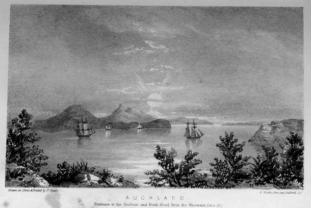
The entrance to the harbour of Auckland,---the sailing directions for which will be found, Appendix D,---is between a point of land on the northern shore called the North Head, and a particular insulated rock named the Bastion Rock, on the southern shore, about a mile distant from each other, and that is the average width of the anchorage ground up the harbour. From the Bastion Rock, eastward of the town, to another small island or rock called the Sentinel, westward of Auckland, is a distance of about five miles. The land opposite the town, on the northern shore of the Waitemata, forms a peninsula, from a large bay running in, which is quite shallow at the entrance, and the greater part dry at low water. On this peninsula is the North Head, 280 feet above the level of the sea, on which is erected a signal station, to communicate to the town the arrival of vessels in the offing.
The town of Auckland is on the southern shore of the River Waitemata, in latitude 36 deg. 51' 27" south, and longitude 174 deg. 45' 20" east.
The town is situated in the middle of the harbour, the river extending about five miles to the westward, and terminating in a large bay, the southern
[Image of page 31]
TOWN OF AUCKLAND.
side of which is very shoal, but on the northern shore there is deep water, seven fathoms, and the bay, into which two creeks or small rivers discharge themselves, runs north-westerly for many miles towards the western coast. The banks of these two rivers abound with kauri, tanikaha, and other valuable timber, and it is from hence that much building timber is with facility, in a few hours, brought down to Auckland. On the south-western extremity of this Bay is another small river, running about seven miles southerly towards Manakoa harbour, near the Northern Head. At the source of this river, as far as which boats can go at high water, there is a portage of only a mile and a half into Manakao harbour.
The commencement of the town of Auckland is situated in a valley running from a Bay called Commercial Bay into the interior. It then extends eastward and westward over undulating ground. The fort in which are the barracks, is on a promontory, perpendicular on two sides towards the sea, between Commercial and Official bays, in the centre of the town. To the eastward of the fort is Official Bay, on which most of the Government officers reside, and where are the public offices. On the summit of the valley forming Official Bay is the Government house, within an enclosure of fifteen acres. Between Government house and the fort, on the high ground, is the site for the Metropolitan Church. Beyond Official Bay is a larger
[Image of page 32]
MOUNT EDEN.
bay, named Mechanics Bay, which is exclusively appropriated to sawpits, brickyards, &c. and for the residences of the artisans in the employment of Government.
This bay, at the eastern side of which is a creek, is the boundary of the town eastward. Beyond commence the suburban lands. By the plan of the Surveyor General, the town of Auckland is to be extended as circumstances may require, to the westward of Commercial Bay.
To the southward of Auckland, within two miles, is Mount Eden, native name Maunga Wao, five hundred feet above the level of the sea. Under this mountain are the remains, the existence of which is still remembered by some of the Nga-te-Whatuas, of extensive native fortifications and of large Pas, or native villages, with entrenchments thrown up of the scoria with flanking enclosures, up the sides of the mountain. The great space occupied, proves there must have been congregated here great numbers of natives in the different villages, at some distant period, which is corroborated by those signs so well known to travellers in New Zealand; such as remains of their Maori, ovens of stones, vast quantities of Pepe shells, &c. These fortified villages or Pas, are to be found in the present day, and are numerous in the interior, on the Waikato Waipa, and the hills near the Lake Taupo, and the east coast. Two views are given as specimens in this volume. From the summit of this moun-
[Image of page 33]
MOUNT EDEN.
tain, the crater of which is 150 feet deep, there is a most beautiful extensive view, embracing on the one side, the whole of the town of Auckland, the river and northern shores of the Waitemata, the islands of Rangitoto, Motu Tapu, Hieh, and Waiheki, with the high land of Coromandel harbour and the Great Barrier Isle in the distance. On the southern side are seen the Heads and the whole of Manakao harbour, the mountains of Albert, Hobson, and Wellington, all similar to Mount Eden, and situated between the Waitemata and Manakao harbour; beyond, the plains of the rivers Thames and Piako, terminating with the high ridge of land between the right bank of the Thames and the eastern coast.
The country between the Waitemata and Manakao harbour, excepting the mountains named, is perfectly level, and the distance between six and seven miles.
By the treaty of Waitangi it will be seen that although the native chiefs ceded the sovereignty of the Islands to her Britannic Majesty, yet the Governor is obliged to purchase from the Natives any land of which it is necessary to have possession to form towns, as well as for the occupation of emigrants, and likewise that any land they choose to reserve for their own uses and cultivation shall be respected and protected by the Government.
The Waitemata district is the property of the Nga te Whatua tribe, and on the decision of the Lieutenant-Governor to fix the town of Auckland
[Image of page 34]
ORAKEI.
on the Waitemata, he purchased from these natives as much land as they chose to dispose of, which comprised the land bounded to the westward by the small river running from near Manakao into the large bay at the western extremity of the Waitemata, and to the eastward by a small creek debouching into the Waitemata, about one mile to the eastward of Mechanics Bay, and extending south nearly as far as the shores of Manakao harbour. Beyond the eastern boundary of the purchase by Government is a beautiful large bay, the native name of which is Orakei, but termed by the Surveyor-General, Hobson's Bay. From this bay there is a narrow inlet or creek, the entrance to another bay, from which diverge two small rivers, southeast and south-west, called by the natives Porewa, and Terewa. This district, including the bay and valley of Hokao adjoining Orakei, and extending south to Manakao, the Nga te Whatuas have reserved for their own occupation and cultivation, and it is the finest land and most beautiful scenery on the Waitemata. The Natives here cultivate large tracts for potatoes, maize, and melons, and from the proximity, two miles by water, to Auckland, bring fresh supplies frequently. They are likewise very serviceable to the wants of Europeans, by supplying the town with firewood at a very moderate rate.
The Nga te Whatua tribe of natives, are not very numerous. Unfortunately they have dwelt in a district, which has been the debateable and fighting ground, for many antecedent years, for the most
[Image of page 35]
THE NGA TE WHATUA TRIBE.
warlike and powerful tribes on the North Island :--- the Nga Pui from the north,--the Nga te Paoa and Nga te Hauwa from the Thames and eastern coast,---and the Waikato tribes from the westward. The Nga te Whatuas, being the allies of one party or the other, according to circumstances, were always subject, from their position, to surprise and attack from the others, and in any great general conflict their villages and property must have suffered from being the seat of war; and thus, from being formerly a numerous, powerful, influential people, the whole tribe now does not exceed two hundred and fifty fighting men. Such has been the exterminating effect of these internal native wars throughout New Zealand, that there are numerous instances of native tribes, that numbered some twenty and thirty years since, many thousands,---as the tribe of George, at Wangaroa, who captured the "Boyd," and others on the western coast,---of whom at this day not an individual exists, and the name of the tribe itself is only known as associated with the land they formerly possessed and occupied. The possessions of the Nga te Whatuas extend from Kaipara, to the southern shore of Manakao Harbour, where they have a very large ancient Pa, called Mangari, and extensive cultivated grounds, and to the eastward in the Waitemata, as far as the river Tamaki. The Nga te Whatuas are connected by marriage, with the Waikato Natives, who are now the most numerous and powerful tribe in the North Island. The chief of the Nga te Whatuas is Te Kauwau, d 2
[Image of page 36]
THE NGA TE WHATUA TRIBE.
a native very much respected for his peaceable habits, vet for his steady friendship when engaged in war. He is a very mild unassuming old man, and very desirous to gain the friendship of Europeans. His eldest son, Te Reweti, the hereditary chief, is very acute and intelligent, particularly as to the interests of his tribe, in all his transactions with Europeans. He conducts all the affairs of his father and his tribe, and possesses very great influence over them. He married a widow of a great Waikato chief, and daughter of another celebrated chief. She is a very superior native, and is always working at her needle, surrounded by her women, or else reading her Bible. The Natives who have become what they term Missionaries, in other words, converts to the Christian faith, have generally, when baptized, received a Christian and sometimes sir-name. Thus, Te Reweti is named William Davis, after the missionary of that name, and his wife is named Martha. Te Reweti has a younger brother named Hira or Peter, and an orphan cousin, Paora or Paul, who are of high birth and rank among the Natives, and are fine specimens of the present race of New Zealanders.
The site of the town of Auckland is certainly judiciously chosen for a seat of Government, and for a central depot of the various products, hereafter, from the different parts of the Northern Island. Inspection of the chart will shew what easy and extensive communication, there is coastwise for small vessels, without experiencing the danger of the open
[Image of page 37]
RIVER TAMAKI.
seas. From Auckland, eastward of the southern shore, there is, about five miles distant, the river Tamaki, which has a very wide estuary; but a spit of sand running nearly across, just at the entrance of the river, renders it difficult and hazardous for large vessels, although a brig of 200 tons burthen has entered. As soon as the entrance is passed, there is deep water for some miles. It is a beautiful river, with fine cultivable land on both sides. About five miles from the mouth of the river, on the left bank is a creek of great depth leading into a small beautiful bay, close at the foot of a high volcanic mountain, the native name of which is Mogia, but now called Wellington. Here, although quite deserted by natives, there are the same description of defences as at Mount Eden, and the remains of a most extensive Pa, with their former cultivated grounds, on which are now growing wild, in luxuriant vegetation, tares, cabbages, turnips, celery, and grass. The tares were in October, (Spring) 1840, in full blossom, four feet high, and there were some acres completely covered with them. On this spot, about nineteen years since, there was fought a most sanguinary battle, in which the whole tribe here were either slain or carried into slavery. From the information of Te Kauwau, the chief of the Nga te Whatuas, who was present, above seven thousand natives perished in the fray. The battle was between the tribes from the north, headed by Pomare, Titore, &c. &c, in conjunction with the Waikato and Nga te Whatua chiefs and tribes,
[Image of page 38]
MOUNT WELLINGTON.
against the Natives of the Tamaki and the Thames districts. From the nature of the country it is probable that Mount Eden and its defences was the position of the former party, and Mount Wellington that of the latter.
Everywhere the country bears strong evidence of much greater native population than at present exists, and in the interior these evidences and remains of warlike feuds, with always the sacred (tapu) burial spot adjacent, remind the traveller, that in all countries, either of classic renown or of the untutored savage, human passions are the same, and that time deals equally with all. Here, in this far distant and comparatively unknown region, has existed for ages the same thirst for glory,---the same desires and attempts for aggrandizement of territories,---the same defences and stratagems of war,---the same respect, reverence and honour to the tombs of the brave,---as in the most polished and civilized nations; and the traveller, while he feels surprise, cannot but also be impressed by corresponding emotions as when visiting similar spots famed in the annals of more enlightened kingdoms.
At the summit of Mount Wellington there is a very large crater, as deep as half its height, at the bottom of which the lava has been thrown up in successive layers as regular as if formed by human hands.
The river Tamaki runs up meandering above three miles beyond this bay to a creek, at the head of which there is a portage of about three quarters
[Image of page 39]
MANAKAO HARBOUR.
of a mile into Manakao harbour, at its eastern extremity. It is over this portage that the Natives drag their canoes and produce in their excursions from the Waikato river, and Manakao, to the Waitemata, Tamaki, and neighbouring ports. From Manakao harbour, which is fifteen miles long, and nearly nine miles broad, on the south-western side, there is a small river, the Awaroa, which runs towards the Waikato river, where again there is a short portage, a distance of 2,260 yards, by the measurement of Captain W. C. Symonds, Deputy Surveyor General of New Zealand, over which the Natives transport their canoes. The Waikato river is navigable for small craft, drawing not more than eight feet water, one hundred miles into the interior, and then separates itself into two branches, east and west, the latter, the Waipa, which is also navigable for boats, runs through fertile plains into the valley of the Waihou, or Thames, the central and richest district of the Northern Island, and sheltered from the south-westerly gales by a high ridge of mountains along the western coast. Therefore it is evident with what facility, communication, and conveyance of produce and supplies of merchandize, can be accomplished between Auckland and the interior on the western coast.
Continuing from the Tamaki eastward, along the southern shore of the Waitemata, there is a river called Wairoa, running several miles up the country, parallel to the course of the Tamaki.
Still further eastward, about forty-five miles from
[Image of page 40]
COROMANDEL HARBOUR.
Auckland, is the frith of the Waihou, or Thames river, on the eastern side of which is Coromandel Harbour.
Coromandel Harbour has good anchorage, but not sufficient depth of water throughout the sheltered part of it for many large vessels, as the eastern side shoals off very much, and the only safe place for vessels of any great draught of water is on the western side under the land. The entrance to the harbour is two miles wide, with deep water close to both shores, particularly the northern. In that part within the harbour which is open to its mouth, when the wind is south-west, and blows hard, there sets in a heavy rolling sea, rendering it unsafe for vessels to run the risk of dragging their anchors so close to a shallow lee shore. Here there are some Englishmen established in the beautiful small bays around the harbour, and there are also settlements of cultivated tracts of the Natives, who are numerous, and belong to the Nga te Poa tribes of the Thames district. The principal chief at Coromandel harbour is a very old man named Te Horeta; he remembers Captain Cook when he visited Mercury Bay, and is not a little proud of his acquaintance.
From Coromandel Harbour to Mercury Bay, on the eastern coast, is a distance of about sixteen miles overland. It is at this latter place that H. M. S. Buffalo was wrecked in a most tremendous gale from the north-east in August, 1840; but from the skill and judgment of Captain Wood in running her direct on to the beach with the flood tide, the
[Image of page 41]
THE RIVER THAMES.
crew and stores were saved. In Mercury Bay there is safe anchorage in certain parts, such as Cook's Bay, where Captain Cook anchored, and likewise at the mouth of the river at the south-western extremity of the harbour, where there is four and five fathoms water close to the shore, and sheltered from all winds. But the entrance to the harbour is exposed to the north-east, and there are rocks at the mouth which render it only safe to enter with certain winds.
It is in the forests on the mountains, between Coromandel Harbour and Mercury Bay, that the finest and largest kauri trees are found, and it is for the supplies of spars that vessels visit these two harbours.
The frith of the Thames, to the southward of Coromandel harbour, is not navigable for large vessels, as there are sand banks, and very shallow water at the southern part, where the rivers Thames and Piako discharge themselves: but for small craft there is sufficient water, with a rise and fall of tide of ten feet. The entrance to the former river is at the south-eastern extremity of the frith. There are two fathoms water at the mouth at low tide, and the tide runs up nearly fifty miles, rendering the river, for that distance, navigable for large boats or barges, and if it were cleared from some large trees or snags, it might be navigated by such craft as far as the falls near Mata Mata, which is, by the river's course, above one hundred miles from the entrance. Small boats and canoes can go up nearly to the source of the river, which is in a high mountain, called 'Horu
[Image of page 42]
THE RIVER PIAKO.
Horu,' near to 'Roto Ma,' one of the lakes of Roto Rua. The Thames, from it source, runs a little to the westward of north, but winding in its course to the frith. Below Mata Mata it receives three smaller rivers, which have their source in the chain of mountains running from Cape Colville to the Bay of Plenty, which forms the eastern boundary of the valley of the Thames, and which shelters it from the eastern coast. These rivers are the Wai Riri, the Ohenemuka, or sacred river, and the Hekatia.
The Wai Riri has its source on the table land above the hills on the right bank of the Thames, and discharges itself into that river near Mata Mata. This river is celebrated for its magnificent waterfall, which gives the name to the river "Wai Riri," or "Foaming Water,"---nearly one thousand feet in perpendicular height, and which can be seen in the valley westward above twenty miles distant. The Ohenemuka runs from its source through a most beautiful valley, with hills skirting its banks, abounding with Kauri. The Hekatia is a smaller river that discharges itself into the Thames, above twenty miles from the frith.
About ten miles distant from the mouth of the Thames, at the south-western extremity of the frith, is the entrance to the river Piako, at a little distance from which it divides itself into three branches. The small river on the left bank, has its source in a ridge of hills which bound the valley on the westward, and separate it from the plains of the Waikato and Waipa. The source of the Piako,
[Image of page 43]
ISLAND OF WAIHEKI.
is in the Maakawa Hills, not far distant from the course of the Waikato river. The entrance to the Piako is very shallow at low ebb tide, but with the flood, the rise of which is ten feet, large boats can enter, and go many miles up the three rivers, but it is not accessible for such a distance as the Thames.
This valley or district of the Thames and Piako, which may be computed to comprise above two thousand square miles, contains more alluvial soil, and is more available and adapted for grazing and agriculture, than any other part of the North Island.
Returning from the frith of the Thames to the Waitemata, between Coromandel Harbour and Auckland, there is the beautiful island of Waiheki, with numerous sheltered bays and small harbours. It is about fifteen miles long, and from four to eight miles broad. This island abounds in Kauri timber, and there are beautiful romantic spots for cultivation. Between Waiheki and the North Head, are two islands, Motu Tapu and Rangitoto, and two smaller, between the former and the main land, called Hieh and Motu Koreho.
The island of Rangitoto has been a volcano, and is remarkable for the height, nearly 1000 feet, of its peak. It is a mass of volcanic scoria, interpersed with thick low woods.
The communication, as above described, by the rivers and shores to the eastward, to the valleys of the Thames and Piako, and to the interior on the western coast are not the only advantages peculiar to Auckland.
[Image of page 44]
TUTUKAKA---RUSSELL.
The distance from Auckland to Point Rodney is forty miles; and to Cape Colville, forty-five miles.
From the North Head of the harbour of Waitemata, there is the whole eastern coast up to the North Cape, a distance of above 150 miles, which includes numerous harbours and districts, peculiarly adapted to support a lucrative coasting trade.
First to the northward, fifteen miles distant from Auckland, are the harbours and bay of Maurangi, with deep water three miles up the river for any vessels. Matakana is the next harbour. Still further northward is Wangari, surveyed by H. M. S. Buffalo, in 1834. It is close under Bream Head, which protects it from the north and north-east.
Then follows Tutukaka, a safe harbour for small vessels, and where there are already settlers profitably engaged in the timber and coasting trade.
Wangamuma is a small harbour between Tutukaka and Wangarura, which is an excellent harbour and district, and where H. M. S. Buffalo took in a large cargo of spars.
Then succeeds the Bay of Islands, a fine capacious harbour, affording shelter in all weathers to any number of ships. It is now so well known and has been so often described, that any observations here would be superfluous, excepting that the Government town of Russell is situated at the southern extremity of the harbour in latitude 35 deg. 12' south, and longitude 174 deg. 12' east. Towards the North Cape, distant from the Bay of Islands twenty-five miles, is the harbour of Wangaroa, ad-
[Image of page 45]
WANGAROA.
jacent to the fertile, beautiful districts of Mongonui and Kaitaia.
Wangaroa is one of the most beautiful and capacious harbours in New Zealand. Any number of vessels of any tonnage are certain and secure of good anchorage with from six to twelve fathoms water, and completely protected from the sea and every wind. The shores are bold and ships can anchor within a short distance from them. The entrance to the harbour is narrow but its exact position is known by one of the Islands of the Cavalles at the northern end of the group, about three miles distant from the mouth of the harbour.