CHAPTER XVIII: Ngawhas, and Puias; boiling springs, solfataras and fumaroles.
[Image of page 389]
CHAPTER XVIII.
Ngawhas, and Puias; boiling springs, solfataras and fumaroles.
The country between lake Taupo and the East Coast. -- Analogy between the hot springs in New Zealand and Iceland. -- Departure from Taupo. -- The Karapiti fumarole. -- Orakeikorako on the Waikato, and its geysers. -- The Pairoa range and its fumaroles. -- The boiling springs on the Waikiti. -- Tropical ferns. -- Rotokakahi. -- Arrival at lake Tarawera. -- Mr. and Mrs. Spencer. -- The Tarawera mountain. -- The warm lake Rotomahana and its boiling springs. -- Rotomakariri, the cold lake. --Rotorua. -- The obliging chief Pini te korekore. -- Ohinemutu and its warm baths. -- The geysers of Whakarewarewa. -- The solfataras Tikitere and Ruahine. -- Lake Rotoiti. -- Origin of the hot springs.
Appendix. Chemical analysis of the water and sediments of some hot springs.
From the table-land, upon which, on the North-shore of Lake Taupo the picturesque Tauhara volcano arises, there extends in a northeasterly direction with a gentle slope towards the Bay of Plenty the Kaingaroa 1 plain, an extensive plain, fifteen miles wide and channelled by numerous valleys. Vast quantities of pumicestone cover the almost tree-less plain, the scanty soil of which produces only a meagre growth of grass and low shrubs. It appears, as though in olden times a powerful stream had taken its course over the plain to the sea. On the East-side the plain is bordered by the Te Waiti range striking in the direction of the East Cape; on the West-side by a volcanic table-land cut up and broken by faults and dislocations into a thousand hills and mountains, which
[Image of page 390]
separate the sterile pumicestone plain from the wood-clad Patetere plateau.
The Waikato, after leaving Lake Taupo, shapes its course North-East for a distance of fifteen to twenty miles, flowing through a broad, terraced valley on the boundary of the Kaingaroa plain. It is not until after the junction of the Pueto river, below the Pah Tetakapo, that the river turns in a keen bend toward Northwest, and enters the mountainous region at Mount Whakapapataringa. In a deep gorge with numerous rapids the river breaks through the mountains, emerging again near Maungatautari into the broad plain of the middle Waikato-basin.
Along the whole distance from Lake Taupo to Maungatautari the river is innavigable on account of its numerous rapids. The land on both sides consists of trachytic tuff, of pumicestone and of partly vitreous, partly crystalline rhyolithic lavas, the flow and extent of which is to be traced to the volcanic centre of the Tongariro and Ruapahu mountains. While the deep terraced valleys are the result of a long continued erosion by water, we see, on the other hand, the effects of the volcanic fire displayed in an immense number of hot springs, in which the country abounds. If we suppose two parallel lines to be drawn from Lake Taupo, touching its East- and West-shores and extending in a N.E. direction as far as the Bay of Plenty, then these two lines, including the range of hills and mountains situated between the Kaingaroa plain and the wooded Patetere plateau, border likewise the space, upon which from more than thousand places hot vapours arise, calling forth all those phenomena of boiling springs, fumaroles, mud-volcanoes and solfataras, for which the North Island of New Zealand, and especially the "Lake District," are so remarkable. The southernmost point of this wonderful zone of hot springs, which by far exceeds all others in the world in variety and extent, is the Tongariro volcano with its solfataras and the northern end is marked by the ever steaming Island of Whakari in the Bay of Plenty, a distance of 120 seamiles. 2
[Image of page 391]
The phenomena are similar to those upon Iceland, and as the Icelanders distinguish their hot springs as Hverjar, Namur, and Laugar, so also the Maoris make a similar distinction, although so not quite marked, between Puia, Ngawha and Waiariki. The Hverjar upon Iceland are either permanent fountains, whose boiling water is continually in a state of ebullition; or intermittent ones, whose water shows a vehement ebullition only at certain periods, when it reaches the boiling point, while during the intervals it is in a state of calm repose, its temperature often falling
[Image of page 392]
considerably. To the Hverjar belong, for example, the celebrated springs of Haukadal, the great Geyser and the Strokkur, and with those the Puias of Now Zealand correspond. The word Puia is especially used in the Taupo country, to designate the intermittent, geyser-like fountains of Tokanu, of Orakeikorako on the Waikato and of Whakarewarewa 3 on Lake Rotorua. Puia has moreover the more general meaning of crater or volcano, and is applied to active as well as extinct volcanoes. Namur upon Iceland are the non-intermittent springs, such as the solfataras of Krisuvik and Reykjahlid, having no periodical eruptions; and the same are in New Zealand the Ngawhas, a term especially used for non-intermittent springs, for the solfataras and sulphurous hot springs on the Rotomahana, Rotorua, and Rotoiti. Finally the springs suited to bathing-purposes, the water of which never reaches the boiling-point, and all naturally warm baths are called Waiariki, corresponding to the Laugar of Iceland. 4
A visit to the Puias, Ngawhas, and Waiarikis was the main object of my journey from Lake Taupo to the East Coast. I had the choice of two routes; either the direct route on the right bank of the Waikato across the Kaingaroa plain to lake Rotomahana (two or three days journey); or the road along the left bank via Oruanui to Orakeikorako, and after here passing the Waikato, along the Pairoa range to lake Tarawera, three or four days journey. Dieffenbach in 1841 had taken the former route; 5 I therefore, chose
[Image of page 393]
the latter, and the more so, because according to the statements of the natives, a great many interesting points could be visited on this route.
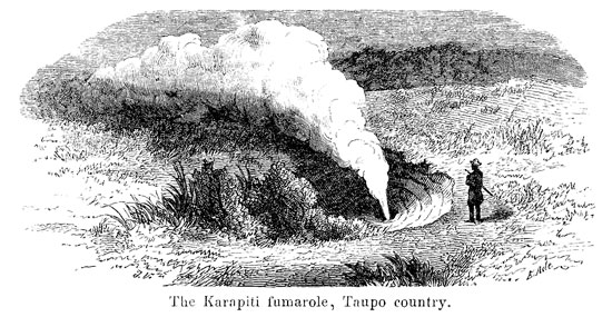
April 22. -- The mountains had wept tears on the day of our arrival on Lake Taupo, and to-day they wept again at our departure. Lest we should feel too sorry at parting, Tongariro and Ruapahu were wrapped in clouds, so that we were unable to see them. In the dreariest weather we wandered over the pumicestone terraces on the left bank of the Waikato, through a very broken and treeless country, looking waste and dreary in its scanty garb of grass and fern and with its dry water-courses. Soon, however, our attention was again engrossed. About two miles from Tapuaiharuru we entered the Otumaheke valley. A rivulet of warm water (71 deg. F.) flows through it, and on its left bank, a little off the road, a colossal column of steam whirls high up in the air. It was only with great caution that we could approach the place, from which the steam issued, because around there the bottom of the valley is literally perforated and furrowed by fissures and crevices, from which hot steam streams forth; whilst in the numerous pot-shaped holes about, a gray clay-coloured mud, or turbid milky water can be seen boiling. Besides, the whole ground is heated to a considerable extent, and boiled perfectly soft into an ferruginous clayey mass, from which small mud-cones protrude. The steam and mud-holes seem here continually to shift their positions. The Lycopodium cernuum found everywhere in hot climates and around hot springs has settled down also here in luxuriant growth. We safely reached the place, where with immense force, and amid loud hissing and booming the steam is streaming out of a circular hole in the loose masses of pumicestone at the foot of the hill. It is high-pressure steam, without a trace of any other gas, and bursts out through a small aperture in the depth of the circular hole in a somewhat slanting direction, with a sound like letting-off the steam from a huge boiler, and with such force, that branches of trees and fern-bushes, which we flung into the jet of steam over the hole, were tossed into the air, twenty or thirty feet high. The natives call this
[Image of page 394]
steam-spring, the column of which is seen already from the East-shore of Lake Taupo, at a distance of 12 to 15 miles, Karapiti (encompassed, circular).
After another mile we came to a second valley with its direction towards the Waikato. A little distance off the road, on the right side of the valley, there was likewise steam ascending from numerous places. The ground about these places appeared of a reddish color. No doubt this locality and the one previously referred to are those that Dieffenbach visited in May 1841, on his journey from Otawhao to Lake Taupo, and of which he has given us a description in his "Travels etc. Vol.I. p.327-329." Yet, various changes must have taken place since that time, as Dieffenbach at the first named locality does not at all mention the large Karapiti-fumarole, but speaks of a powerful fountain, the water of which was thrown out to a height of 8 to 10 feet and was heated above the boiling-point. Perhaps the fountain has changed to a steam-spring, in a similar way as the "roaring geyser" in Iceland, -- not to be confounded with the great geyser -- which in former times had periodical eruptions of water, now emits only steam.
At two p.m. we reached the native village Oruanui, at the foot of a wood-clad hill of the same name, and as we found here commodious shelter in a house specially built by a native for travelling Europeans, we determined upon remaining to wait for better weather.
[Image of page 395]
April 23. -- Heavy storms and showers of rain had continued all night; but when in the morning the rain ceased and even the sun was pooping through the cloud-banks, we set out again. It was for the first time, since we had left Pukawa, that we again entered the bush. The rain, however, commenced anew, and. by marching onward with all possible speed and without the least delay, we strove to reach as soon as possible the Pah Orakeikorako ou the Waikato, a distance of ten miles from Oruanui. We passed the Orakanui valley, climbed a wooded range of hills, and on arriving upon the open height of Tehapua, we had an interesting-glance, through smaller side-valleys, at the Waikato valley far below, from which heavy clouds of steam were ascending, the harbingers of a new region of hot springs, the Puias of Orakeikorako. We reached the Pah about noon. It is situated upon an elevation on the left bank of the Waikato, about 200 feet above the river, and had been lately fortified anew on account of impending hostilities between the tribes of the Taupo and some others dwelling more North. The terraces on the descent facing the Waikato had been dug anew; but instead of the palisades of stanch beams, as in olden times, there was only a scanty miserable hedge-fence put up, which, although double and triple, could be almost overthrown with the mere hand. A ridiculous fort, indeed, about which, however, the Maoris of the vicinity made much ado. In the middle of the Pah I had my tent pitched; but a heavy shower of rain inundating the whole ground, I was obliged to seek shelter in the hut of the chief Hori from the terrible tempest, which now burst forth in all its fury. It was the first violent storm with electric discharges since our departure from Auckland, and I was compelled to await in quiet resignation the coming morn, in order to visit the Puias at the foot of the Pah. Hori informed me, that a fortnight ago three faint shocks of an earthquake were distinctly felt here.
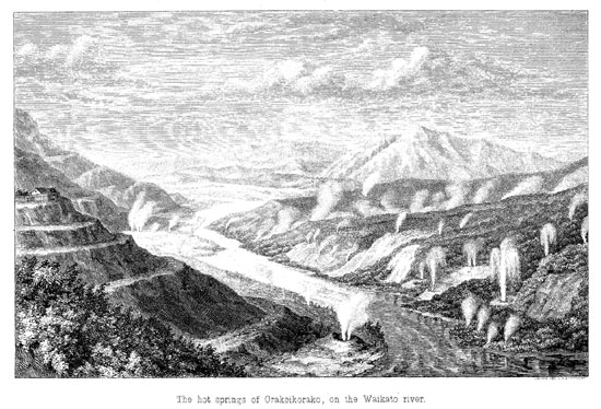
April 24. -- The tempest had abated during the night. In the morning a dense fog lay upon the Waikato; but it soon vanished; the sun shone brightly into the valley, and now -- what a sight! In swift course, forming rapids after rapids, the Waikato was plunging
[Image of page 396]
through a deep valley between steep-rising mountains; its floods, whirling and foaming round two small rocky islands in the middle of the river, were dashing with a loud uproar through the defile of the valley. Along its banks white clouds of steam were ascending from hot cascades falling into the river, and from basins full of boiling water, shut in by a white mass of stone. Yonder a steaming fountain was rising and falling; now, there sprung from another place a second fountain; this also ceased in its turn; then two commenced playing simultaneously, one quite low at the river-bank, the other opposite upon a terrace; and thus the play continued with endless changes, as though experiments were being made with grand waterworks, to see whether the fountains were all in perfect order, and whether the water-falls had a sufficient supply. I began to count the places, where a boiling water-basin was visible, or where a cloud of steam indicated the existence of such. I counted 70 points, without however being able to survey the whole region; and among them there were numerous, intermittent, geyser-like fountains with periodical water eruptions. The sketch which I drew on the very spot, can be but a faint illustration of the grandeur and peculiarity of the natural scenery at Orakeikorako.
The region of springs extends along the Waikato a distance of about a mile on both banks, from the foot of the steep Whakapapataringa mountain South, as far as the foot of the wood-clad Mount Tutukau North. The larger portion of the springs is situated upon the right bank; it is, however, difficult of access, since the rapid river cannot be passed close by the springs themselves, but only far above or below; and then it would be necessary to climb along the steep-sloping river-banks covered with dense undergrowth, where the traveller upon a soil totally softened by hot vapours would be every moment in danger of sinking into boiling mud. I was obliged to content myself with a closer inspection of the springs situated on the left river-bank just below the village.
The most remarkable springs of the whole region are comprised within a large whitish mass of silicious deposit, 120 yards long, and of equal breadth, by the natives called Papa Kohatu, the flat
[Inserted page]
[Image of page 397]
stone, which with a gentle inclination from the foot of the Tutukau-mountain extends into the Waikato. Close by the river bank lies, first of all, the Puia Te-mimi-a-Homaiterangi. 6 The manner, in which we practically experienced the intermittent properties of this fountain, proves sufficiently, how much caution is necessary in approaching such springs for the first time and without expert guides. My travelling companions wished to enjoy the luxury of a river bath early in the morning, and had just deposited their clothes, when suddenly they heard violent detonations, and saw the water madly boiling up in a basin close by. They started back afright, but only just in time to escape a shower-bath of boiling water; for now amid hissing and roaring a steaming water-column was being ejected from the basin in a slanting direction, and to the height of about 20 feet. By the time I had heard of the treacherous geyser, and arrived at the place, every thing had long subsided again into quiet repose, and in the pot-like basin four to five feet wide I only saw water as clear as crystal gently bubbling up. It showed a temperature of 202 deg. F., proved a perfectly neutral reagent, and tasted like weak broth. The first water-eruption, which I observed with my own eyes, took place at 11h 20' a. m. The basin, a short time previous to the eruption, was full to the brim. Amid a distinctly audible, murmuring noise in the depth of the basin the water came more and more into violent ebullition, and then was suddenly expelled with great force at an angle of 70 degrees in the direction of S.S.E, to a height of 20 to 30 feet. Together with the water huge volumes of steam burst forth from the basin with a loud hissing sound, partly veiling the spout of water. This lasted one and a-half minutes, then the expelling force decreased, the water rose only two or three feet high, and after two minutes the play of water ceased entirely amid a low, gurgling noise. On now stepping up to the basin I found it empty, and was able to look down to a depth of eight feet, into a funnel-shaped, gradually contracting aperture, from which steam escaped with a hissing noise. Gradually the water rose again; after the lapse of ten minutes the
[Image of page 398]
basin was full again, and at 1h 36' p.m. the second eruption took place; at 3h 40' p.m. the third, which I had occasion to observe. Consequently the eruptions seem to occur about every two hours. The sediment of this, like of all surrounding springs, is silicious; the recent sediment is soft as gelatine, gradually hardening into a triturable mass, sandy to the touch, and finally forming by the layers deposited one above the other a solid mass of rock of a very variable description at different places both as to colour and structure. Here it is a radiated fibrous or stalky mass of light-brown color; there a chalcedony hard as steel, or a gray flint; at other places the deposit is white with glossy, conchoidal fracture like milk-opal, or with earthy fracture like magnesite. A second Puia, about 30 yards distant from the geyser, is called Orakeikorako. The name is said to have reference to the transparent, shining water. It is an elliptical basin of eight feet length and depth, by six breadth, half-filled with gently bubbling water clear as crystal. The main spring, however, to which the Papa Kohatu chiefly owes is origin, is close by the foot of the sloping hills. It is a powerful fountain continually bubbling up to a height of two to three feet, the water of which showed a temperature of 209 deg. F., and had a distinctly noticeable smell of sulphuretted hydrogen. The chief accompanying me told me, that for two years after the earthquake of Wellington, in 1848, this fountain was a geyser spouting to a height of 100 feet (no doubt somewhat exaggerated), and throwing up with powerful force even large stones as fast as they were flung in. Three smaller basins close by, which in former times were probably likewise independent springs, are now filled by the discharge of the fountain, and form excellent natural bathing tubs. The water flows from one basin into the other, so that there is a triple choice of temperature. In the first basin I found 116 deg. F., in the second 110 deg. F., and in the third 96 deg. F. The latter, at a depth of 3 to 5 feet has exactly the dimensions of a large bathing-tub; its basin is formed of snow-white silicious deposit, resembling the purest marble, and its crystalline water looked so inviting, that I could not resist taking a bath in it. To these
[Image of page 399]
springs, moreover, considerable medicinal virtues are ascribed. At Orakeikorako we met an Irishman, belonging to Port Napier, who told us, that he had been conveyed thither perfectly lame with the gout, and that after a short use of those baths he was entirely restored.
On both sides of the Papa Kohatu, up and down the river, there are, concealed in the copse of the river-banks numerous boiling mud-pools, which can be approached only with the utmost caution, because the softened soil, unprotected by a sheet of silicious deposit, gives way most readily. The largest of these mud-basins I saw a few hundred yards down the river. It has an elliptical form, is 14 feet in length, 6 to 8 feet wide and equally deep. There was boiling in it a mass of mud dyed intensively red by oxide of iron; clammy bubbles of mud rose, burst, exhaling a sulphurous stench, and relapsed -- a truly infernal sight. Woe unto him, who here misses a single step! The very thought of it made me shudder; and yet, such fearful accidents have frequently occurred here both to children and adults.
On the opposite river-bank lies the Puia Tuhi-tarata. The discharge from a basin full of sky-blue shining water forms a steaming cascade over strata of silicious deposits shelving off in terraces towards the river and varying in the gaudiest colors, white, red, and yellow. The same scene recurs five or six times up the river; and intermediate there are points exhibiting periodical eruptions, on some places every five minutes, at others every ten minutes. 7 But wherever bare, reddish patches occur along the river-terrace, there steam can be seen ascending; the same is the case at countless places in a side-valley intersecting the river-terrace. But impossible as it is to see every thing here, it is yet more impossible to describe every thing. Orakeikorako with its hot springs would prove an inexhaustible field for years of observation.
April 25. -- Accompanied by Captain Hay I ascended the summit of the Tutukau mountain, rising North of Orakeikorako to
[Image of page 400]
the height of 2100 feet. The summit is mostly wooded; nevertheless we found some points, from which we had a good view North and South. On the height above and in the midst of the woods we found potatoe-fields and native huts. It is an old Maori custom dating from the times of war, to establish at remote and less accessible points, usually in large forests, stations and plantings, upon which the people might fall back in case of need. So there are also travelling-stations, lying off the road upon hidden paths and known only to the tribe which has established them.
About noon we set out from Orakeikorako. Te Hori conducted us across the river in quiet water at a passage below the rapids, giving us a proof of his admirable dexterity, as he had first to steer the canoe from a place farther up the river through the eddying and foaming rapids. We stood on the bank and shouted a loud enthusiastic bravo to the bold chief as he dashed in the little craft through the frightfully eddying floods.
Through a small side-valley, called Rotoparu, we ascended the right bank of the Waikato, crossed a fern hill and came into the Rotoreka valley, a dreary and swampy plain with here and there an isolated Ti tree. Towards the West the valley is bordered by low, wood-less hills; towards the East, a high rocky bluff ascends almost vertical, extending in the direction of N. 24 deg. E., in a straight line. Above the steep precipice numerous rugged cliffs tower up, and in the middle of the rocky wall a high, wooded peak Pairoa (or Paeroa) projects towards the West. After this prominent peak I have called the whole extent of the bluff the Pairoa range; and it is easily to be seen, that along this range an immense dislocation took place, that the almost perpendicular western side of the range is caused by a "fault" corresponding to a deep fissure in the earth-crust, and that the low-lands between the Pairoa range East and the Patetere-plateau West were produced by a breaking or sinking of a large part of the volcanic table-land. In a most remarkable manner the fissures, and the lines of dislocation are also indicated by the numerous hot springs issuing along the Pairoa range, at the foot of the precipice, on its slopes, and even above
[Image of page 401]
on the heights. In warm, dry weather the steam-clouds are less visible; yet the red patches on the sides, devoid of every trace of vegetation, point out from afar the places, from which sulphuric acid, sulphuretted hydrogen, sulphur and steam are continually escaping, producing fumaroles, hot springs, boiling mud-pools and solfataras. On the one end of this remarkable break in the table-land, which can be traced to a distance of 18 miles, Orakeikorako is situated, and on the other end the famous Rotomahana, the marvels of which far surpass every thing else occurring upon New Zealand in the shape of hot springs. Upon the western fissure, parallel to the Pairoa fissure, are the hot springs and solfataras of Waimahana, Rotorua and Rotoiti; and at the North-East side of the break are the lakes Tarawera, Roto Kakahi, Okataina, Okareka etc.
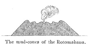
At three p.m. we encamped close at the foot of the Pairoa peak amid a dense growth of Manuka. It was a dismal neighbourhood; for close by our camping-ground lay a terrific basin about 30 feet in diameter, in which a bluish-gray clay-pap was boiling. By the side of this mud-basin, concealed among the bushes, arose a flat mud-cone about 10 feet high, with a regular crater on the top. A heavy cloud of steam, which, accompanied by a slight detonation, suddenly escaped from the crater, attracted our attention. Carefully sounding the ground with our sticks, we approached the mud-crater, and saw a deep, funnel-shaped hole, in which a thick boiling mass of mud rose higher and higher, heaving up in large bursting bubbles. As the mud rose quite close to the brim, we receded a short distance, and then observed a second eruption, during which again steam escaped with a hissing sound, while the mud discharged itself over the margin of the basin. Quite a number of such mud-volcanoes extend on the steaming slopes of the Pairoa peak, playing in the gayest colours of red, white and yellow, while at the top of the mountain a powerful column of steam is seen to ascend, which, as the natives told me, belongs to the great fountain Te Kopiha. I am of the opinion, that this whole portion of the mountain up to the Te Kopiha fountain, -- being, as it seems, thoroughly decomposed by hot vapours, -- will some day cause a
[Image of page 402]
sudden catastrophe by falling in, and covering the Rotoreka-plain with a flood of hot mud.
Our route continued across the marshy plain at the foot of the Pairoa-range. Anxious to reach a convenient place for camping, we marched on till after night fall; but we had after all to be content with a place, where no firewood was to be had. We had arrived at the Waikite creek, where numerous deep pools with boiling water are scattered right and left, close by the road-side, and the natives deemed it a dangerous risk to pass there in the dark. The Maoris with timely foresight had provided themselves with tent-poles from the Manuka-shrubs on the Pairoa, and thus we camped in the immediate vicinity of the hot springs, the seething noise of which I had all night in my ears.
April 20. -- The Waikite springs are real boiling wells. In well-shaped, circular holes, six, eight or ten feet wide and equally deep, partly clear, partly turbid water of a milky colour is boiling; in some of them also mere mud. None of them are full to the brim; nor are there any silicious incrustations to be seen. It is in consequence of this peculiarity, that plants can settle and spread upon the inside of the holes, and that the vegetation in them sometimes reaches a depth of four feet. Whatever grows there, grows in a uniformly warm steam-atmosphere. The plants were ferns of luxuriant growth; but forms such as we had as yet observed nowhere else. We were therefore very desirous of gathering them, although the job was not entirely without danger. The most successful method for accomplishing our object was that one of us laid himself flat upon the ground, and, while the others were holding him fast by the legs, gradually pushed the upper part of his body so far over the margin of the hole, that he could reach far enough down with one arm. Our delight on first seeing the beautiful ferns was fully justified; for the result proved they were species, 8 which are usually found only in tropical countries, and singularly occur here, in the interior of the island, isolated at a place, where by means of hot springs the proportions of moisture and temperature
[Image of page 403]
peculiar to the torrid zone are produced. The first seeds of those ferns, however, must have been wafted thither by atmospheric currents from the tropical regions of Australia or America, or from the tropical islands of the South-sea. On both sides of the Waikite there are no doubt upward of 20 boiling wells to be counted; their discharges flow into the creek, the temperature of which is consequently considerably raised.
At the Waikite we left the Pairoa line, and following a small valley we ascended in a northerly direction the Whaihorapa-Plateau. We passed two grassy plains, which like drained lakes form basins in the plateau. The first plain bearing the name of Waihorapa, was especially remarkable for a large, at some places widely gaping rent of the ground, which could be traced for a whole mile, in the direction of N. 24 deg. E., consequently parallel with the Pairoa-fissure; moreover for numerous funnel-shaped holes, 20 to 80 feet deep, reminding us of the funnel-shaped holes in the soil of Calabria. Those phenomena are no doubt produced by earthquakes, by which the country is said to be very frequently visited.
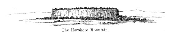
Upon an open height we had a clear view of the Horohoro Mountain six miles to the West, which acts a prominent part in the Maori-traditions. It is one of the most striking table-mountains of the country, rising isolated from the plain with vertical sides, a remaining fragment of the formerly unbroken table-land. Thence our road lay through bush for a short distance, and descending: through a dry valley we came to the charming shores of the Roto-Kakahi (muscle-lake).
Thus we had reached the first lake of the Lake District, so famous for its numerous lakes and the beauty of its landscape. like a miniature-picture of the magnificent Alpine lakes of Upper Italy, the little lake with the picturesque island Motutawa in the
[Image of page 404]
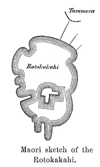
middle, lies hidden among the mountains. At Teriria, a catholic village on the South-side of the lake, we halted to rest for an hour. From the natives, who received us with a most cordial welcome,
I inquired the names of the most note-worthy points on the lake. Their zeal to serve me was so great, that, as a whole crowd were speaking at the same time, there was no possible chance to understand any thing at all, until one of them hit upon the excellent plan of tracing with his knife, after his own fashion, the outlines of the lake upon the sand, and thus to fix the various points of it. Although these outlines did hardly correspond with the real shape of the lake, such as it resulted from my own subsequent observations; yet the primitive sketch at the hands of a man, who had perhaps never in all his life seen a map, appeared to me noteworthy enough to copy and present it here.
My travelling companions crossed in a canoe over to the N.E. end of the lake, I myself climbing along the eastern shore, -- where a path is cut on the steep mountain-side, -- for the purpose of making surveys of the various points of the lake. At the other end of the lake, I was not a little surprised at striking a broad carriage-road. It was the first indication of the proximity of the Tarawera Mission station. The road led to a mill; the Wairoa river, an outlet of the Rotokakahi, which drives the mill, was well bridged over; then I came to a settlement, Hereaupaki, laid out in European style, and not far from it, on the left, above at the edge of the bush, lay the hospitable dwelling of the Rev. Mr. Spencer, the central point, from which emanate all the civilizing influences, the cheering proofs of which are met everywhere in the neighbourhood. We had been expected for a long time, and Mrs. Spencer, in the absence of her worthy husband, welcomed us most heartily. We met our photographer, Mr. Hamel, here again in the best state of health.
[Image of page 405]
April 27. -- Mr. Spencer's residence, Temu, situated between the lakes Rotokakahi and Tarawera, at the edge of the bush upon an eminence about 500 feet above the level of the Tarawera, 9 is certainly, to every visitor of that country, a place not easily to be forgotten on account of both the amiable hospitality found there, and the exquisite beauty of its site. I too, spent here several days, which I number among the most pleasant during my travels.
It was on a delightful morning, when from the garden adjoining the house my eyes roved for the first time over the smooth deep-blue mirror of the Tarawera lake; resplendent in the radiant sun-light, the landscape appeared to me perhaps doubly beautiful. The scenery of Tarawera lake surpasses in wilderness and grandeur that of any of the lakes in the lake district. The word signifies burnt cliffs. Its general form, exclusive of its deep side-coves, is that of a rhombus, with its main diagonal running from West to East. In this direction it is seven miles long, having a breadth of about 5 miles. The lake is probably very deep; for its shores are mostly rugged, rocky bluffs, shaded by Pohutukaua trees. The chief ornament of the adjoining landscape is the Tarawera-mountain 10 with its crown of rocks, divided into three parts by deep ravines; it rises on the south-eastern side of the lake to a height of at least 2000 feet above the level off the sea. It is an imposing table-mountain, consisting of obsidian and other rhyolitic rocks; and it is not to be wondered at, that its dark ravines and vertical sides have given rise to many an odd story in vogue among the Maoris. Among others, a huge monster, 24 feet long, resembling a crocodile, is said to haunt the clefts between the rocks, devouring every one who dares to scale the mountain. The Rev. Mr. Chapman, a well-known missionary of Maketu, once, despite all
[Image of page 406]
remonstrations of the Maoris, ascended the mysterious mountain. After searching for a long time he found a small lizard scarcely span-long, which he took with him to show to the Maoris, and to convince them, what kind of crocodiles really live there. An aged chief on seeing the lizard made the funny remark, that, if that huge monster was no longer seen, it must have been eaten up by cats.
The outlet of lake Tarawera is on the Eastside; it is the Tarawera river or Awa o te Atua, running along the northern foot of the Putauaki mountain (Mount Edgumbe) and emptying into the sea near Matata on the Bay of Plenty. Besides numerous smaller tributaries it receives the discharges of five small lakes; from South-East the joint discharge of the Rotomahana and Rotomakariri (the warm and cold lakes); from North-West the waters of the Okataina and Okareka lakes, 11 and from the West the Wairoa river, which, flowing from the Rotokakahi, at a short distance from the missionary station forms a picturesque waterfall 80 feet high, and empties into the lake through a narrow gorge of rocks. At the shore of the lake there are various Maori settlements, the original names of which, similar to the Taupo settlements, were changed into biblical appellations, such as Ruakeria into Kariri (Galilee), Te Ariki into Piripai (Philippi). A large portion of the land about the lake is still densely wooded; the cultivated portions, on the other hand are said to be very fertile. The principal rock found in the Tarawera country is a finely granulated rhyolite containing black mica, which makes an excellent building-stone and looks very much like finely granulated granite. With the banks of crystalline
[Image of page 407]
structure, however, alternate banks of a hyaline texture, in which the mass assumes more or less the character of obsidian.
On the 28th April I started to the Rotomahana, -- by land, because the gale blowing from South-West was too heavy, to cross the boisterous Tarawera in the small canoes. The distance is ten miles. The road loads over the heights on the South-shore of lake Tarawera. It is a much frequented foot-path, but very tiresome, because the traveller has continually to climb up and down over the broken ground. On the road we had a view of the regular volcanic cone Patauaki (Mount Edgumbe, 2575 feet high), a distance of about twenty miles to the North-East. The saddle-shaped excavation on the top indicates distinctly the existence of a crater, which, however, is extinct. At four p.m. we reached the northern shores of the far-famed Rotomahana (warm lake).
I do not think, that the impression the traveller receives at first sight of the small, dirty-green lake, -- with its marshy shores, and the desolate and dreary-looking, treeless hills about it, covered only with a dwarfish copse of fern -- corresponds in any degree with his previous expectations conceived from hearing so much about the marvels of this lake. So it was at least with us. The lake lacks all and every beauty of landscape scenery; that which makes it the most remarkable of all New Zealand lakes, -- indeed we may well say, one of the most wonderful points of the world -- must be observed quite closely, it being mostly hidden from the eyes of the traveller on his first approach. It is only by the steam clouds ascending everywhere, that he is led to suspect something worth seeing.
We found natives there with a canoe, as Mr. Spencer with friendly care had sent already a week ago provisions to the lake, supposing that we would travel directly from Taupo to the Rotomahana. In the canoe we crossed over to a small island in the lake, called Puai, and recommended to us by the natives as the best dwelling place during the time of our stay about the lake.
Puai is a rocky cliff in the lake, 12 feet high, 250 feet long, and about 100 feet wide. Manuka, grass and fern grow upon it, and for occasional visitors of the lake small raupo-huts have been
[Image of page 408]
erected, in which we made ourselves at home as well as circumstances would admit. I believe, however, that if we had not known that others before us had lived for weeks at that place, we should hardly have been induced to spend a single night there after a close examination of the spot. It is almost the same as living in an active crater. Round about there is a continual seething and hissing and roaring and boiling, and the whole ground is warm. In the first night, the ground upon which I was lying, grew gradually so warm from below, despite the thick underlayer of ferns and despite the woollen blankets, that composed my bed, that I started from my couch unable to bear it any longer. To examine the temperature, I formed with my stick a hole into the soft clay soil, and placed the thermometer into the aperture. It rose at once to boiling-point; on taking it out again, hot steam came hissing out, so that I hastened to stop the hole up again. In reality the island Puai is nothing but a torn and fissured rock, which, boiled entirely soft in the warm lake, threatens every moment to fall to pieces. Hot water bubbles up all around partly above partly below the surface of the lake. On the South-side of the island is a boiling mud-pool; blocks of silicious deposit, scattered about, point to large hot springs existing in former times, and even now-a-days hot steam escapes from numerous fissures. No fire is required here for cooking; wherever we dug but a little into the ground, or cleared the existing crevices of the crusts formed on them, there we could cook our potatoes and meat by steam. In some places the crevices are covered with sulphurous crusts and a strong smell of sulphurous acid was observed; in other places I found under cakes of silicious deposit films of fibrous alum. East of Puai and separated from it by a channel only 40 feet wide, is a second island Pukura (red lump). It is of the same description as Puai, smaller in circumference, but higher by several feet, and has likewise several huts, which some of my Maoris chose for their dwelling place. On these islands we had our headquarters during two days, and from them we undertook our excursions round the lake.
I will give a brief account of my observations, describing the
[Image of page 409]
principal springs more in detail with a view of furnishing a guide to the numerous visitors of the lake. 12
The Rotomahana is one of the smallest lakes of the lake district, not even quite a mile long from South to North, and only a quarter of a mile wide. According to my measurement it is 1088 feet above the level of the sea. Its form is very irregular, on the Southside, where the shore is formed by swamps, three small creeks are meandering and discharging themselves into the lake, the Haumi from Southwest the Hangapoua from Southeast, the middle creek without a name. In many places of those swamps warm water streams forth; hot mud-pools are also visible here and there; and from the projecting points muddy shallows covered with swamp-grass extend almost as far as the middle of the lake. At its Northend the lake grows narrow, and where the Kaiwaka creek flows out, there are again on both sides nothing but grass-swamps and shallows. Only in the middle the water is deeper; and the shores East and West are high and rocky. It justly bears the name of "warm lake." The quantity of boiling water issuing from the ground both on the shores and at the bottom of the lake, is truly astonishing. Of course, the whole lake is heated by it. But on making attempts to ascertain the temperature of the water, it is soon found to be very different in various places. Where the rising of gas-bubbles indicates a hot spring at the bottom of the lake, the thermometer will be often seen to rise to 90 or 100 deg. F. Near the mouth of the cold creeks, the water of which showed a temperature of 50 to 52 deg. F., the temperature is found to be only 60 to 70 deg. F.; but in the middle of the lake and near its outlet 80 deg. F, may be considered as the mean temperature of the lake. In bathing and swimming through the lake, the change of temperature is very easily felt; but care must be taken not to come too close to any of the hot springs. The water
[Image of page 410]
is muddy-turbid, and of a smutty-green color; neither fish, nor mussel-shells live in it. On the other hand the lake is a favourite haunt of countless water- and swamp-fowls. Various kinds of ducks, water-hens, the magnificent Pukeko (Porphyrio melanotus), and the graceful oyster-catcher Torea (Haematopus picatus) enliven the surface of the water. These birds have their, brooding-places on the warm shores, while they have to seek their food in the neighbouring cold lakes. In certain seasons of the year the natives institute regular hunts; at other times, however, they refuse every body, even Europeans, the pleasure of shooting, declaring the birds tapu. In former years, natives are said to have constantly dwelled about the lake; but of late, they seem to shun more and more this dismal laboratory of subterraneous forces, where rocks are dissolved in water, and rocks again are solidified from the water; and consequently the shores of the lake are usually uninhabited. Numerous observations lead to the conclusion, that constant changes are going on at the Rotomahana, that some springs go dry; others rise; and especially the earthquakes, which are felt here from time to time, seem to exercise such a changing influence. The main interest is attached to the Eastshore. There are the principal springs, to which the lake owes its fame, and I will now describe the principal springs in their succession from North to South on the East-shore of the lake, such as they are found by the side of the road, generally taken during a short visit to the lake.
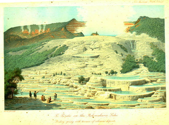
First of all is Te Tarata 13 at the N.E. end of the lake with its terraced marble steps projecting into the lake, the most marvellous of the Rotomahana marvels. About 80 feet above the lake on the fern-clad slope of a hill, from which in various places hot vapors are escaping, there lies the immense boiling cauldron in a crater-like excavation with steep, reddish sides 30 to 40 feet high, and open only on the lake-side towards West. The basin of the spring is about 80 feet long and 60 wide, and filled to the brim with
[Inserted page]
[Image of page 411]
perfectly clear, transparent water, which in the snow-white incrustated basin appears of a beautiful blue, like the blue turquoise. At the margin of the basin I found a temperature of 183 deg. F., but in the middle, where the water is in a constant state of ebullition to the height of several feet, it probably reaches the boiling-point. Immense clouds of steam, reflecting the beautiful blue of the basin, curl up, generally obstructing the view of the whole surface of water; but the noise of boiling and seething is always distinctly audible. Akutina (Augustus), the native who served me as guide, asserted that. sometimes the whole mass of water is suddenly thrown out with an immense force, and that then the empty basin is open to the view to a depth of 30 feet, but that it fills again very quickly. Such eruptions are said to occur only during violent easterly gales. The confirmation of this statement would be of great interest. If it be true, then the Tetarata spring is a geyser playing at long intervals, the eruptions of which equal perhaps in grandeur the famous eruptions of the great Geyser upon Iceland. The Tetarata-basin is larger than the Geyser-basin, 14 the mass of water thrown out, therefore, must be immense. The reaction of the water is neutral; it has a slight salty, but by no means unpleasant taste, and possesses in a high degree petrifying, or rather incrustating qualities. The deposit of the water is like that of the Iceland springs, silicious, not calcareous, and the silicious deposits and incrustations of the constantly overflowing water have formed on the slope of the hill a system of terraces, which, as white as if cut from marble, present an aspect, which no description or illustration is able to represent. It has the appearance of a cataract plunging over natural shelves, which as it falls is suddenly turned into stone. I had these terraces, which are truly unparalleled in their kind, photographed and drawn from various points of view, and the annexed
[Image of page 412]
colour-print is a copy of those views, as true to nature as possible. In order to receive the full impression of that marvellous freak of nature, it is necessary to have climbed those steps, and to have studied the details of its structure.
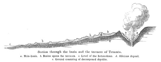
The silicious deposits cover an area of about three acres of land. For the formation of those terraces, such as we see them to-day, doubtless thousands of years were required. Forbes, judging by the thickness of the silicious deposits on the great Geyser of Iceland, which he estimates at 762 inches, and by the observation, that an object exposed to the discharge of the geyser-water for the space of 24 hours, is covered with a sheet of paper-thickness, has calculated the approximate age of the great Geyser at 1036 years. Similar calculations might be made also with regard to the Tetarata fountain, by examining the thickness of the silicious incrustations.
The flat-spreading foot of the terraces extends far into the lake. There the terraces commence with low shelves containing shallow water-basins. The farther up, the higher grow the terraces; two, three, some also four and six feet high. They are formed by a number of semicircular stages, of which, however, not two are of the same height. Each of these stages has a small raised margin, from which slender stalactites are hanging down upon the lower stage; and encircles on its platform one or more basins, resplendent with the most beautiful blue water. These small water-
[Image of page 413]
basins represent as many natural bathings-basins, which the most refined luxury could not have prepared in a more splendid and commodious style. The basins can be chosen shallow or deep, large or small, and of every variety of temperature, as the basins upon the higher stages, nearer to the main-basin, contain warmer water than those upon the lower ones. Some of the basins are so large and so deep, that one can easily swim about in them. In ascending the steps, it is, of course, necessary to wade in the tepid water, which spreads beside the lower basins upon the platform of the stages, but rarely reaching above the ankle. During violent water-eruptions from the main-basin, steaming cascades may occur; at ordinary times, but very little water ripples over the terraces; and only the principal discharge on the Southside forms a hot steaming fall. After reaching the highest terrace, there is a extensive platform with a number of basins, 5 to 6 feet deep, their water showing a temperature of 90 to 110 deg. F. In the middle of this platform, there arises, close to the brink of the main-basin, a kind of rock-island about 12 feet high, decked with Manuka, mosses, lycopodium and fern. It may be visited without danger, and from it the curious traveller has a fair and full view into the blue, boiling and steaming cauldron. Such is the famous Tetarata. The pure white of the silicious deposit in contrast with the blue of the water, with the green of the surrounding vegetation, and with the intensive red of the bare earth-walls of the water-crater, the whirling clouds of steam, -- all together presents a scene unequalled in its kind. The scientific collector, on the other hand, has ample opportunity of filling whole baskets with the most beautiful specimens of the tenderest stalactites, of incrustated branches, leaves etc.; for whatever lies upon the terraces, becomes incrustated in a very short time.
From the foot of Tetarata fountain a path leads on the slope of the hill to the great Ngahapu (alias Ohapu). This fountain, shut up in by a thicket of shrubs, lies close by the margin of the shore, about 10 feet above the level of the lake. The colossal column of steam continually ascending from it betrays its locality
[Image of page 414]
from afar. The basin is oval, 40 feet long, 30 feet wide; the water in it clear and transparent, but nearly always in a terrific state of ebullition; it is but for some short moments, that the basin relapses into a calm repose; then it boils up madly anew, now more on this side, now on that, raising its foaming crest; the water is thrown up to a height of 8 to 10 feet and a terrific surf of boiling hot waves lashes the walls of the basin with wild uproar, so that the observer stricken with awe shrinks back from the scene. But the elevated margin of silicious deposit prevents the free overflow of the water. The natives constructed an artificial outlet, conducting1 the water to several bathing-basins. The thermometer rose in the hot spring to 210 deg. F.; the water having a slight reddening effect on blue litmus-paper. The silicious deposits of the fountain have a smutty brown colour, and in the rear on the hill-side, where steam is rising from crevices and fissures, there also sulphur-crusts are found. The little Nga. hapu, a basin in which turbid, muddy water is bubbling, lies farther up on the hill; but it is difficult of access.
Nearest to the great Ngahapu, more to the South, and close to the shore is Te Takapo, an incrustated basin, 10 feet long and 8 feet wide, with clear, gently boiling water of 206 deg. F. Sometimes this fountain is said to rise in a jet 30 to 40 feet high. The numerous smaller springs, bubbling mud-pools, and tabular, lightly incrustated holes along the shore between Tetarata and Tetakapo bear no special names. Near Tetakapo there are some deserted huts, and a few yards farther there is a ravine, called Waikana-panapa (the coruscating water), extending in a N.E. direction for a short quarter of a mile, in the background of which lies the Rotopunamu (green lake). The entrance to the ravine is overgrown with thicket, and rather difficult; it also requires considerable caution, because very suspicious places have to be passed, where the traveller is in danger of being swallowed up in heated mud. The inside of the ravine has the appearance of a volcanic crater. The bare walls, utterly destitute of vegetation, are terribly fissured and torn; odd-looking, rocky serratures threat-
[Image of page 415]
ening every moment to break loose, loom up, like dismal spectres, from red, white and blue fumarole-clay, -- evidently the last remains of the decomposed rooks. The bottom of the ravine is formed by fine mud, and thick, burst and broken plates of silicious deposit lie scattered about, like cakes of floating ice after a thaw. Here there a big cauldron of mud is simmering, there a deep basin full of water is boiling, next to this lies a terrible hole emitting hissing jets of steam, and farther-on small mud-cones are seen, from two to five feet high, vomiting forth, volcano-like, from their craters hot mud with a deadened rumbling, and imitating on a small scale the play of Large fire-volcanoes. Quite in the background, perhaps, 100 feet above the level of the Rotomahana, lies the green lake. It was a dirtyish-green water-basin, 40 feet in diameter; the reaction of the water was acid; its temperature 63 deg. F. The basin
was surrounded by a flat, and partly broken shell of silicious deposit, and seemed to me to belong to an extinct fountain.
Towards South, at the mouth of the ravine, there lies quite picturesque between rocks and bushes, about 40 feet above the level of the Rotomahana, the fountain Ruakiwi (Kiwi-hole), a basin 16 feet long and 12 feet wide, with clear water of 210 deg. F., which is in a constant state of gentle ebullition. The stony deposit, -- lacking, however, the beauty of the Tetarata terraces, -- extends as far down as the lake, at the shore of which there is another smaller fountain, Te Kapiti.
From the Waikanapanapa valley, opposite to the two islands Pukura and Puai, the shores of the lake become steep and rocky; hot springs gush out from below, under the surface of the lake, while above on the side of the hill the huts of the deserted settlement Ngawhana (or Ohana) lie scattered by the side of the spring bearing the same name. Here the natives, probably for bathing-purposes, have constructed square-basins of sinter plates and connected them by gutters with the springs on the hill-side. The flat
[Image of page 416]
stones, which are laid across hot places, are said to have served for the drying and roasting of Tawa-berries (of Laurus tawa). To the Ngawhana group belong several hot springs, which have all a share, more or less, in the silicious deposits covering the slope of the hill. Ngawhana itself is a quiet, hot water-basin without any special pecularities. Farther up, about 100 feet above the lake, is the Koingo (the sighing), 15 an intermittent fountain, from which discharges of water take place three or four times a day, alternating, as the natives say, with those of the neighbouring Whatapoho. The basin of that fountain, 9 feet long and 5 feet wide, is encompassed by a crust of silicious deposit. When I stopped up to the margin of the basin, the water was quiet and but slightly steaming. It was so low, that no discharge took place through the gutter laid by the natives. Suddenly, however, it commenced to stir again; the water rose, soon the whole basin was filled to the brim, and finally boiled over in a surf bubbling up to a height of 3 or 4 feet. This lasted about ten minutes; then the fountain began to subside again; a low rumbling was heard, as if the water were receding through a small tube, and the water in the basin stood again low and quiet as before. In this state it had a temperature of 202 deg. F.
A few yards apart there is a fountain-basin about 16 feet deep, contracting like a funnel as it descends; this, years ago, is said to have been an intermittent geyser, but at the time of my visit it was entirely empty. Not far from it is the Whatapoho, one of the most remarkable points on the lake, part fountain, part solfatara, and part fumarole, or rather all three in one. From a deep, shaft-like aperture between brittle, ash-coloured rocks there streams, as from a steam-boiler, hot steam and sulphurous gas with a dismal, moaning sound. It being too dangerous to approach it quite closely, there is no chance of looking down into the depths of the shaft; but it may be easily seen, how the steam-jet is occasionally also throwing out spouts of water. The vegetation is withered
[Image of page 417]
away all around, sulphur-crusts and silicious deposits cover the ground and the crevices of the rocks. Sometimes the Watapoho is said to throw out a boiling water-column to a considerable height.
The springs hitherto mentioned are only the principal springs on the Eastside of the Rotomahana; they all lie on the slope of a hill -- rising about 200 feet about the level of the lake, overgrown with fern and Manuka -- which steams on more than a hundred other places, and the rhyolithic rocks of which are totally decomposed by the hot vapours into a more or less ferruginous mass of clay, from which all traces of the original structure of the rock have been effaced. South of the steaming hill the shores are flat. Here, on the Southeast side of the lake lies the Wakaehu (water in motion), and a number of boiling springs bubbling forth from the sand and mud of the shore, partly with clear and partly with muddy water. There are also three lagoons in those flats: Rangipakaru, Te Ruahoata 16 and Wairake; and in the rear, there rises an isolated hill, Te Rangipakaru (broken sky), on the Westside of which, from a crater-shaped excavation, a powerful solfatara steams forth, depositing great quantities of sulphur. The Southside of the lake does not present a single spring of any noteworthy size.
On the West-shore, the great terrace-fountain Otukapuarangi 17 is a side-piece to Tetarata. The terraces extend as far as the lake, and the ascent is made, as it were, by artificial marble-steps, decked on both sides with Manuka, Manuwai, and Tumingi bushes. The terraces, although not so grand as at the Tetarata, are, on the other hand, neater and finer as to their structure. Besides, a light pink hue imparts an intrinsic charm to the marvellous structure. The platform is at a height of about 60 feet above the lake; it is 100 yards long, and equally broad. It contains neat basins three or four feet deep, full of transparent, sky-blue water of 90 to 110 deg. F. In
[Image of page 418]
the background, shut in by half naked walls tinged with various colours, red, white, and yellow, lies the large spring-basin, a great cauldron 40 to 50 feet in diameter, and probably very deep. The water is usually quiet, shining blue, merely steaming, but not boiling, and has a temperature of 179 deg. F.; the ascending vapours smell of sulphurous acid. Round about the basin a light tincture of sulphur is also noticed, and here and there on the side-walls of the crater thick crusts of sulphur have been deposited. At the northern foot of the terraces is the great solfatara Te Whakataratara, 18 a crater-shaped hole, open towards the lake and full of hot, yellowish-white, muddy water, of a strong acid reaction, -- a real sulphur-lake, from which a hot, muddy stream flows into the Rotomahana. In the crevices of the walls enclosing the sulphur-lake very fine sulphur-crystals are to be found.
A little beyond the lake, in a small side-valley, lies the Atetuhi; and in the marshy flats, at the N.W. end of the lake, the Te-Waiti fountain. Also at the outlet of the Rotomahana towards lake Tarawera, on both sides of the Kaiwaka river, there are still numerous Ngawhas observed, which have special appellations such as Te aka manuka, Te mamaku, Te poroporo, Tamariwi, Makrowa, Te karaka etc., which, however, I had no opportunity of examining more closely.
Altogether about 25 large Ngawhas may be counted on the Rotomahana; the number of smaller springs, coming to light at innumerable places upon an area, occupying about two square-miles, I do not even dare to estimate. As those hot springs according to the experience of the natives have proved very effective in the curing of chronic cutaneous diseases and rheumatic pains, I have no doubt, that, at no very distant period, this remarkable lake will become the centre of attraction not only for tourists of all nations, but also a place of resort for invalids from all parts of the world. Moreover the Rotomahana has been repeatedly used as a climatic place of cure. Mrs. Spencer told me, that some years ago she took fifteen Maori children, affected with the whooping-cough, to
[Image of page 419]
the Island Puai, and that in its uniformly warm temperature they all recovered in a very short time. I regret to say that my stay upon the island was too short, and I was too much engaged in other observations, to find time for making comparative thermo-metrical observations. 19
Before leaving lake Rotomahana,, the warm lake, however, I must also make mention of the Rotomakariri, or the cold lake, situated East of the Rotomahana at the foot the Tarawera moun-
tain. It is smaller than the Rotomahana and shows very remarkable circular coves reminding me of the circular tuff-crater basins in the vicinity of Auckland. However, having seen the lake only from the heights above the Rotomahana, I am not able to say, how that phenomenon is to be explained. East of the Rotomakariri, there is another little water-basin, surrounded by swamps, and the joint outlet of both is the Awaporohoe, which unites with the Kaiwaka river between the Rotomahana and Tarawera. A third, much larger lake, about three miles long and one mile wide, by the natives called Rere-whaka-Aitu, is said to lie in the Kaingaroa plain about five miles East of Rotomahana; a lake, of which as
[Image of page 420]
yet no mention has been made in any account of travels, or on any map.
Our return-trip to Temu, on the 30. April, we made by water. The Kaiwaka, 20 the outlet of the Rotomahana, is the water-route into lake Tarawera. It empties into the South-East cove of the lake, called Te Ariki, which is very picturesquely surrounded by steep, rocky shores. Near the Pah Maura on a peninsula stretching far into the lake, the river turns into the great lake, and after a passage of one and a half hours we reached the lauding at Temu, at the mouth of the Wairoa river. On our return we had the pleasure of becoming acquainted with Mr. Spencer, an American by birth; and the constant heavy rain preventing our departure, we spent two more days with that amiable, hospitable family. This delay was quite welcome to me, because by it I found time to finish the topographical sketches, deriving great benefits for my purpose from the excellent local knowledge of Mr. Spencer. My botanical collections were considerably increased by the kind contributions of the amiable daughter of the house.
On the 3. May we took leave, and set out to lake Rotorua, the second in size in the lake-district. Our intention to shorten the distance by passing across the Rotokakahi to the West-cove of that lake, we were obliged to renounce on account of the boisterous West-wind which churned the little lake into madness; we took the road by lake Tikitapu, a small, deep-blue lake of triangular shape, and about one mile long, picturesquely situated between steep, partly wooded heights. It is separated from the Rotokakahi only by a narrow range of hills, probably keeping up the connection with the same by means of a subterraneous water-course. On the North-side of the lake we came into bush for a short distance, then over fern-hills and through small, grass-covered valleys running in various directions, into the Waipa plain; thence we had to ascend a low, woodless range, and the picturesque Rotorua with the hot springs
[Inserted page]
[Image of page 421]
of Whakarewarewa in front, lay spread before our eyes. Here I made halt for the purpose of making observations for the map, and committing the beautiful scenery to paper. The height bears the name of Te whaka-he kinga-whaka, and for the benefit of the lovers of interesting specimens of volcanic rocks I add, that the rocks along the road consist of obsidian, containing numerous, lavender-blue spherolites. This kind of rock is found over a large portion of the lake-district (the Ngongotaha mountain near the Rotorua also consists of it); but at the place above mentioned it is easy to knock off good specimens.
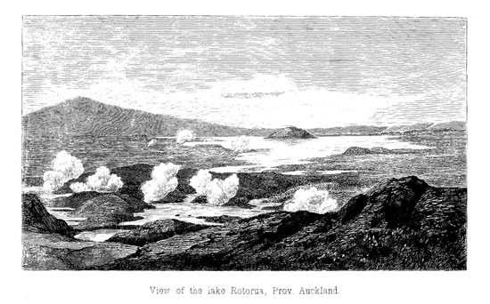
Rotorua means hole-lake or a lake lying in a circular excavation. With the exception of the southern bight, called Te arikiroa, it has an almost circular form with a diameter of about six miles and a circumference of twenty miles. Almost in the precise centre of the lake the island Mokoia is situated, formed by a conical hill rising about 400 feet above the level of the lake and with a Pah on its top. The circular form of the lake, the island in the middle, the white steam-clouds ascending along the shores, all this might easily induce the observer to take the Rotorua to have formerly been a volcanic crater, while in reality this lake, like all the other lakes of the lake-district, was produced by the sinking of parts of the ground upon the volcanic table-land. The depth of the lake is comparatively but small, perhaps at no place more than 5 fathoms; it has numerous shallow sand-banks, and the shores also, with the exception of the North-side, are sandy and flat. It is 1043 feet above the level of the sea, consequently of the same height with the Tarawera lake. On the Southwest-side, the wood-clad Ngongotaha mountain towers up to a height of 2282 feet. This is the highest point of the range of hills encircling the lake. Among the numerous tributaries, the Puarenga river emptying into the lake on the Southeast-side near Whakarewarewa, is probably the most considerable. On the North-side the Ohau Creek forms the outlet of the lake to the Rotoiti, thus connecting the two lakes separated only by a low and narrow isthmus.
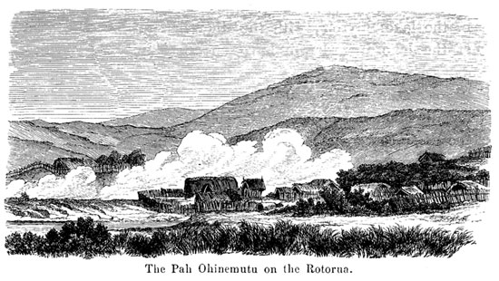
The principal native settlement is Ohinemutu, situated at the
[Image of page 422]
northwestern extremity of the lake; it is a famous old Maori Pah; famous for its inhabitants, and famous for its warm baths. At a distance of three miles from the village, my Maoris had kindled a big fire upon the height, the smoke of which, according to Maori custom, announced our coming to the inhabitants of the Pah, the chief of which had previously invited me by letter to pay him a visit. We hastened past the hot springs of Wakarewarewa, and made straight-way for the Pah. Pini te korekore, the gallant chief of Ohinemutu, accompanied by his special friends, came forth to meet me with due solemnity. He was dressed in a fine European suit, had a cloak wrapped about him, a straw-hat upon his head, and carried a white flag in his hand with the inscription in blue letters: "Sancta Maria, ora pro nobis." After we had approached each other within about 20 yards, he stopped. Bowing very low, and taking off his hat, he shouted to me with a loud voice the usual salutation: "haeremai" (come). I went, shook hands with the chief, exchanging some complimentary words, and then was conducted into the Pah. I found the tent pitched, the meal ready; for such is Maori custom. When they see from afar friends or strangers coming, the women of the village commence at once peeling potatoes, and by the time the ceremony of salutation, accompanied by the usual Tangi (cries of lamentation), is over, the dinner is ready.
Pini te korekore upon better acquaintance became extremely talkative. He had heard of the solemn reception, which the Roman Catholic Bishop Pompallier -- his master -- had been honoured with on the occasion of his visit on board the Novara in Auckland, and was very anxious to have me relate to my friends that he -- a pupil of the Roman-catholic mission school -- had come to meet me with the catholic banner. He was about thirty years of age, had only the lower part of his face tattooed, and had, both in his exterior appearance and manners, adopted a great many of the peculiarities of his French masters. Till late in the evening he continued telling me of the country and its inhabitants, and of the murderous wars and bloody fights, that were fought here.
[Image of page 423]
May 4. -- At breakfast-time, Pini te korekore again made his appearance in my tent, requesting with a solemn air my presence at a most peculiar ceremony. Round about in a circle sat the men of the village. In the middle was a fat pig tied to a post; by the side of it stood six baskets full of potatoes and kumaras, and a heavy sack of flour lay across them. The chief stepped forth into the circle, addressed some kind words to the assembled audience, and by his touching with a rod the pig, the potatoes and the sack of flour, at the same time pronouncing my name "Te Rata Hokiteta," they were dedicated to me and my companions, according to Maori custom, as a present offered in his own and his people's name. Captain Hay in the Maori language returned in my name our sincerest thanks for the hospitable gift.
After breakfast I ascended the Ngongotaha mountain and on arriving at the top I was greatly rejoiced to have an extensive view in all directions reaching to the shores of the Bay of Plenty, and as far as the volcanic island Whakari (White Island), which was seen emitting immense clouds of white steam. The afternoon was devoted to the inspection of the Pah and the examination of the hot springs.
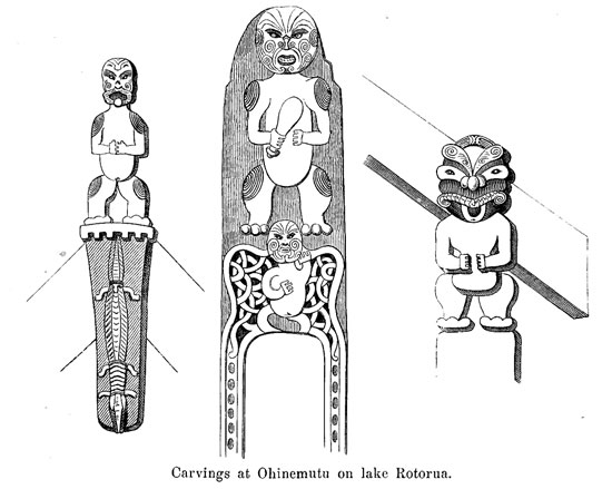
Ohinemutu still bears to some degree the features of an old Maori Pah. The dwellings of the chiefs are surrounded with enclosures of pole-fences; and the Whares and Wharepunis, some of them exhibiting very fine specimens of the Maori order of architecture, are ornamented with grotesque wood-carvings. The annexed wood-cut is intended as an illustration of some of them. The gable-figure with the lizard having six feet and two heads, is very remarkable; at no other place in New Zealand have I seen a similar representation. The human figures are no idols, but are intended to represent departed sires of the present generation. The huts of the village are scattered over a considerable area on both sides of the Ruapeka Bay and on the slope of the hill Puke Roa arising to about 150 feet above the lake. Ohinemutu has a protestant and a catholic church. The place is noted far and near for its hot springs and for its excellent warm baths (Waiariki).
[Image of page 424]
Ruapeka Bay forms the centre of the hot springs. There it seethes and bubbles and steams from hundred places. The principal spring is the Great Waikite at the South-side of the bay. The basin of the fountain communicates with the lake, and it is to the immense quantities of hot water issued forth here, that the whole bay becomes warm and forms an excellent bathing-place. By approaching the fountain more or less, any degree of temperature may be chosen. The water of the fountain is perfectly clear. For some short moments all is quiet in the large basin, only white steam-clouds ascending from it; then a powerful ebullition succeeds in raising the water to a height of four to six feet, sometimes even to ten and twelve feet. Little Waikite, a few yards above, forms a basin four to five feet wide, in which the water rises about every five minutes several feet high, sinking down again during the intervals to a depth of six to seven feet. The temperature I found to be 201 deg. F. In going about between the countless pools of boiling sputtering mud and water, the greatest care has to be taken.
[Image of page 425]
Whoever has once involuntarily bathed his feet in steaming water or boiling mud, will certainly remember it all his life. That even more serious accidents are of no rare occurrence, is proved by several monuments in the shape of figures carved of wood, which are posted in those places where persons have met with an untimely death.
From the Ruapeka Bay the hot springs continue in a southwestern direction on the foot of the Pukeroa, along the Utuhina Creek as far as the small settlement Tarewa. In this direction there are moreover two small warm ponds, Kuirau and Timara, fed by hot springs, both favorite bathing-places of the natives. Also on the South- and East-sides of the Pukeroa steam is seen to ascend
from various places. Tabular blocks of silicious deposit, two to three feet thick, of a mass resembling milk-opal, lie scattered about over the slope and the base of the hill, indicating, that the activity of the springs in former periods especially on the East-side of the hill was still far more extensive than now, or that the springs change their place from time to time. The natives have special springs for bathing, for cooking and also for washing. On places, where only hot vapour escapes from the ground, they have established vapour-baths, and upon heated ground they have warm houses for the winter season, of which it is said, that no vermin of any
[Image of page 426]
kind is able to exist in them. The whole atmosphere in and about Ohinemutu is so constantly impregnated with watery vapours and sulphurous gases as to make them plainly perceptible to the sense of smell. This, however, seems only to improve the physical condition of the inhabitants; for they are known to be an extraordinarily robust set of Maoris. Haupapa, a renowned chief of Ohinemutu, who was absent at the time of my visit, but whom I happened to meet at Maketu, is a giant in height and a Hercules in strength.
May 5. With three hearty cheers we took leave of the kind and hospitable people of Ohinemutu. The gallant Te Pini, in a large war-canoe, took one half of my company to the Island Mokoia 21 and thence to Te Ngae, a former Mission station on the Northeast-side of the lake; myself, with the other half on foot went the circuit of the lake in order to have an opportunity for farther observations.
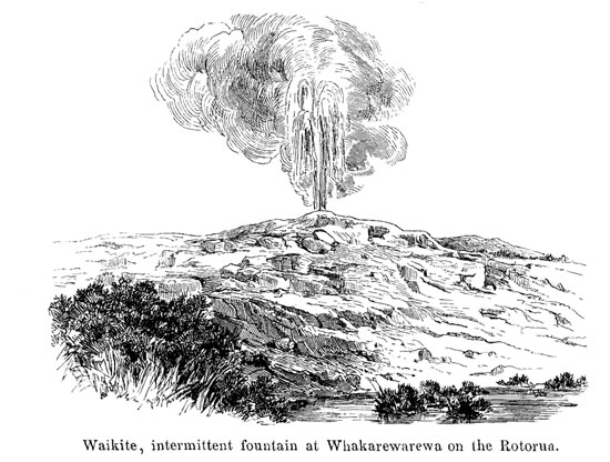
Two and a half miles distant from Ohinemutu in a southeasterly direction is the native settlement Whakarewarewa. Lying at some distance off the direct road from Ohinemutu to Lake Tarawera, it is generally skipped over by tourists, but the springs here exceed those of Ohinemutu in variety and extent. The principal springs are on the right bank of the Puarenga Creek. Seven or eight of them are periodical geysers, having, however, their own, as yet unexplored caprices, as they are not always obliging enough to satisfy the curiosity of visiting travellers. It is said to happen
[Image of page 427]
now and then, that they play all together; the natives assert, that such is generally the case during heavy easterly gales. I was not fortunate enough myself, to witness such a grand spectacle, but had to content myself with observing a small eruption of one of them, the Waikite. It issues from the top of a flat silicious cone,
measuring 100 feet in diameter and 15 feet high, which rising between green manuka and fern-bushes, presents an extremely picturesque sight. The cone consists of white silicious deposit; it has numerous fissures and crevices, which are all incrustated with neat sulphur-crystals; the hot vapours, however, issuing from those fissures, smell neither of sulphurous acid, nor of sulphuretted hydrogen, but merely of sublimated sulphur. At intervals of about eight minutes the Waikite throw out a column of water two or three feet thick to a height of six to eight feet. But in January and February, Mr. Spencer told me, it shows itself in its full glory, spouting to a height of 30 to 35 feet. A little S.E. of the Waikite is the Pohutu. 22 Its basin is 12 feet wide; the masses of sili-
[Image of page 428]
cious deposit surrounding it are very extensive, and piled up to a height of more than 20 feet, fissured and broken by numerous cracks; the sulphur-deposits are here still more distinct than on the Waikite. Parikohuru and Paratiatia are the names of the springs, supplying the large bathing-basins of 50 and more feet diameter, in which the natives, men and women promiscuously, bathe for hours, all cosily smoking their pipes and chatting together. The range of hot springs extends from Whakarewarewa along the course of the Puarenga river, a distance of one and a-half miles, to Tearikiroa Bay on lake Rotorua. The number of smaller springs, of boiling mud-basins, of mud-cones and solfataras, which are scattered over this extensive area, must be counted by hundreds and I will make special mention of only two points more. Near the peninsula Motutara on the West-side of Arikiroa Bay, there is a basin, 16 feet long and 6 feet wide, by the natives called Oruawhata, full of hot water with a temperature of 185 deg. F. and a neutral reaction; close by, a cold waterbasin of 55 deg. F., 80 feet long and 14 feet wide, contains yellowish-white water, acidulated with sulphurous acid, and of a strong acid reaction. The Arikiroa Bay also has yellowish-white water of an acid reaction; numerous sulphur-crusts, the yellow hue of which upon the white sand-beach of the shore is visible at a great distance, and a strong smell of sulphuretted hydrogen indicate from afar the solfataras on the shores and at the bottom of said bay. All these phenomena, however, cease after passing the mouth of the Puarenga Creek, and along the flat East-shore of the lake as far as Te Ngae there are no more hot springs to be met with. Two small lakes are situated on this side, the Rotokawa, a muddy basin in the immediate vicinity of lake Rotoma; and a little farther off between the wooded hills on the Northeast-side the Rotokawau of the size of lake Tikitapu.
Te Ngae, formerly the residence of the Rev. Mr. Chapman, who has of late settled at Maketu, we found deserted. The grounds around the old Mission house are planted with a great variety of fruit trees, and next to it there is a small settlement Waiohewa with a mill, turned by the Te Ngae Creek. The shores of the
[Image of page 429]
lake near Ngae are formed by vertical sandstone and pumicestone crags, 20 or 30 feet high, which are more and more under-washed by the heavy surf raised by West- and South-West winds. I came just in time, to see Te Pini's canoe, with my travelling-companions on board, bravely struggling through the waves of the lake lashed by the howling gale, and landing at length in safety.
After one hour's repose and after a repeated solemn farewell to Te Pini we set out from Waiohewa, taking a Northeast course along a marshy valley, for the purpose of visiting the great Ngawhas or solfataras situated upon the Pumicestone-plateau between the lakes Rotorua and Rotoiti. They are a peculiar group for themselves. Comparable to hideous carbuncles on the surface of a body, those solfataras -- holes, rotten more or less deeply into the ground, surrounded with yellowish-white crusts, and diffusing an offensive odour -- lie bedded among the green fern-lands. Their list opens with Tikitere, not merely a single pool of sulphur, but a whole valley of solfataras, bubbling mud-pools and hot springs. In the middle is a water-basin, 50 to 60 feet in diameter, called Huritini; it seethes and boils and bubbles in all corners, the turbid and muddy water sometimes rising to a height of 12 to 15 feet. Pumicestone-sand cemented with silicious deposits, sulphur-crusts and black mud form a very suspicious soil around, which can only be stepped upon with the greatest caution. The atmosphere is impregnated with sulphuretted hydrogen and sulphurous acid; dense clouds of steam whirling up from the dismal haunt. North of Tikitere are the solfataras Karapo, Te Korokoro, Te Waikari and Te Terata; next, Harakeke-ngunguru, Tihipapa and Papakiore; and finally Ruahine.
Ruahine (from rua, hole, and hine, wife) has the appearance of an active crater. The crater-shaped basin lies on a declivity sloping towards lake Rotoiti; at its bottom black mud may be seen boiling, which by the rising and bursting steam-bubbles is sputtered up into the air to a height of several feet. The column of steam ascending here is designated by the natives Te Wata-Kai-a-Punakirangi, meaning the place where the meal is hung up for Puna-
[Image of page 430]
kirangi. Yellow masses of sulphur are sticking to the many-coloured clay-soil. Black, muddy water flows out of the mud-basin; the valley in front of the basin is covered with sulphur and sinter-crusts, emitting steam from more than hundred perforations. Here also great care is to be taken by the traveller, lest he breaks through into boiling mud. The apertures emitting pure steam the natives use for cooking.
Towards evening we reached the southern shore of lake Rotoiti, and pitched our tents near the Maori village Pukeko at the peninsula Te mihinga-a-terangi-tapu.
May 6. -- Rotoiti or the "little lake," is of a very irregular shape, from West to East about six or seven miles long, and only from one to two miles wide. As regards the character of its scenery it is decidedly one of the most beautiful lakes. Picturesque promontories and peninsulas jutting far into the lake separate the various branches and inlets from each other. On the West-side it is separated from the Rotorua only by a narrow isthmus scarcely half a mile broad, upon which the Pah Morea stands. The Ohua Creek flowing from the Rotorua into the Rotoiti, connects the two lakes. From the northwestern end of the Rotoiti issues the Okere river, which flows into the sea near Maketu on the East-coast. As towards
[Image of page 431]
West from the Rotorua, so the Rotoiti is towards East separated by a low narrow isthmus from the Rotoehu or Roto-ihu (nose-lake). The Rotoehu is said to be three miles long and one and a half miles wide. Its outlet, the Waihi Creek, does not come to light until after a subterraneous course at some distance from the lake. North-East from Rotoehu there is moreover the small lake Rotoma (white lake), so called from its white sandy beach; it is about one mile long, and the last of the lakes in the lake-district, which I have to enumerate. The last hot springs, exclusive of the island Motu Hora and the island-volcanoe Whakari 23 in the Bay of Plenty, are said to be found on the shores of the Rotoehu.
The Fauna of all those lakes is identical with that of lake Taupo. They all are likewise characterized by their total lack of eels.
Having thus given a description of the principal ones of the Thousands of Puias and Ngawhas on the North Island, I will now say few words about general features and about the origin of the springs. We can distinguish three parallel lines of springs, striking in the direction of N. 36 deg. E. One line connects the two volcanoes Tongariro and Whakari. On this line are situated the hot springs of Lake Taupo, the fumaroles of the Kakaramea mountain and the hot springs round Rotomahana. The second line is the line of the Puias of Orakeikorako and of the Pairoa-range; and to the third line belong the hot springs of the Rotorua and the solfataras of the Rotoiti. The chemical and mechanical processes, as
[Image of page 432]
exhibited by the New Zealand hot springs are throughout similar to those of the hot springs upon Iceland. The interesting results, to which the investigations of Krug von Nidda, Sartorius von Waltershausen, von Bunsen and others have led upon Iceland, may therefore be mostly applied also to New Zealand. As to the mechanical processes, the intermittent springs, or those which at certain periods display an increased state of ebullition, -- raised sometimes to regular, geyser-like water eruptions, -- may be distinguished from the permanent springs, the surface of which is in a state of constant repose, or in a uniform state of ebullition. The former may, as I have explained in the beginning of this chapter, be designated as Puias, the latter as Ngawhas. With this distinction corresponds moreover the chemical difference of alkaline and acid springs.
Both kinds of springs owe their origin to the water, permeating the surface and sinking through fissures into the bowels of the earth, where it becomes heated by the still existing volcanic fires. High-pressure steam is thus generated, which accompanied by volcanic gases, such as muriatic acid, sulphurous acid, sulphuretted hydrogen and carbonic acid, rises again towards the colder surface and is there condensed into hot water. The overheated steam however, and the gases decompose the rook beneath, dissolve certain ingredients, and deposit them again on the surface. According to Bunsen's ingenious observations, a chronological succession takes place in the cooperation of the gases. The sulphurous acid acts first. It must be generated there, where rising sulphur-vapour comes into contact with glowing masses of rock. Wherever vapours of sulphurous acid are constantly formed, there acid springs or solfataras arise. Incrustations of alum are very common in such places, arising from the action of sulphuric acid on the alumina and alkali of the lavas; another produce of the decomposition of the lavas is gypsum (or sulphate of lime), the residuum being a more or less ferruginous fumarole - clay, the material of the mudpools. To the sulphurous acid comes sulphuretted hydrogen produced by the action of steam upon sulphides, and by the mutual
[Image of page 433]
decomposition of the sulphuretted hydrogen and the sulphurous acid sulphur is formed, which in all solfataras forms the characteristic precipitate, while the deposition of silicious incrustations is either entirely wanting or quite inconsiderable, and a smell of sulphuretted hydrogen is but rarely noticed. These acid springs have no periodical outburst of water.
In course of time, however, the source of sulphurous acid becomes exhausted, and sulphuretted hydrogen alone remains active. The acid reaction of the soil disappears, yielding to an alkaline reaction by the formation of sulphides. At the same time the action of carbonic acid begins upon the rocks, and the alkaline bicarbonates thus produced dissolve the silica, which, on the evaporation of the water, deposits in the form of opal or quartz or silicious earth, and thus the shell of the springs is formed, upon the structure of which the periodicity of the outbursts depends. Prof. Bunsen -- rejecting the antiquated theory of Mackenzie, based upon the existence of subterraneous chambers, from which the water from time to time is pressed up through the vapours accumulating on its surface, according to the principle of the Heron-fountain -- has proved, in the case of the great Geyser, that the periodical eruptions or explosions essentially depend upon the existence of a frame of silicious deposits with a deep, flue-shaped tube, and upon the sudden development of larger masses of steam from the overheated water in the lower portions of the tube. The deposition of silica in quantities sufficient for the formation of this spring-apparatus in the course of years, takes place only in the alkaline springs. Their water is either entirely neutral or has a slightly alkaline reaction. Silica, chloride of sodium, carbonates and sulphates are the chief-ingredients dissolved in it. In the place of sulphurous acid, the odour of sulphuretted hydrogen is sometimes observed in those springs.,
The rocks, from which the silicious hot springs of New Zealand derive their silica, are rhyolites and rhyolithic tuffs containing seventy and more percent of silica; while we know that in Iceland palagonite and palagonitic tuffs with fifty percent of silica are
[Image of page 434]
considered as the material acted upon and lixiviated by the hot water. By the gradual cooling of the volcanic rocks under the surface of the earth in the course of centuries the hot springs also will gradually disappear. For they too are but a transient phenomenon in the eternal change of everything created.
Appendix
Appendix.
Chemical composition of the water and the silicious deposits of some of the hot springs; the analyses executed in the laboratory of Professor Dr. v. Fehling at Stuttgart.
1. Water.
No. 1. Te Puia-nui, near Tokanu on lake Taupo; reaction alkaline; analyzed by Dr. Kielmaier.
No. 2. Tetarata on the Rotomahana; reaction neutral; analyzed by Mr. Melchior.
No. 3. Ruakiwi on the Rotomahana; reaction neutral-; analyzed by Mr. Melchior.
No. 4. Rotopunamu on the Rotomahana; reaction neutral; analyzed by Dr. Kielmaier.
In 1000 parts of the waters there were contained, of:
|
|
in No. 1.
|
2.
|
3.
|
4.
|
| Silica
|
0.210
|
0.164
|
0. 168
|
0. 231
|
| Chloride of Sodium
|
4.263
|
2.504
|
1. 992
|
1.192
|
| Total residuum
|
4.826
|
2.732
|
2.462
|
1.726
|
Owing to the small quantities of water for analysis (one bottle of each), only silica, chlorine -- computed as chloride of sodium -- and the total amount of non-volatile ingredients could be quantitatively ascertained. Qualitatively, however, the presence of magnesia, lime, sulphuric acid and traces of organic substances has also been proved.
2. Silicious deposits of hot springs on the shores of the Rotomahana, analysed by Mr. Mayer.
No. 1. Tetarata, two samples, a) an earthy powdery mass; b) solidified incrustation.
No. 2. Great Ngahapu.
No. 3. Whatapoho.
No. 4. Otukapuarangi.
[Image of page 435]
I. Pattison (Philos. Magazine 1844. p.495) and
II. Mallet (Philos. Magazine 1853. V. p.285) give the following analyses of the silicious deposits on the hot springs of Lake Taupo, without, however, specifying the localities.
|
|
I.
|
II.
|
| Silica......
|
77.35
|
94.20
|
| Alumina.....
|
9.70
|
1.58
|
| Sesquioxide of Iron.
|
3.72
|
0.17
|
| Lime......
|
1.54
|
Indie.
|
| Chloride of Sodium.
|
--
|
0.85
|
| Water......
|
7.66
|
3.06
|
|
|
|
|
|
|
99.97
|
99.86
|
| specif, grav.
|
1.968
|
2.031
|